|
NATIONAL PARK SERVICE
Atlantic and Gulf Coasts Recreation Area Survey |

|
UNDEVELOPED SEASHORE AREAS IN NEW JERSEY

|
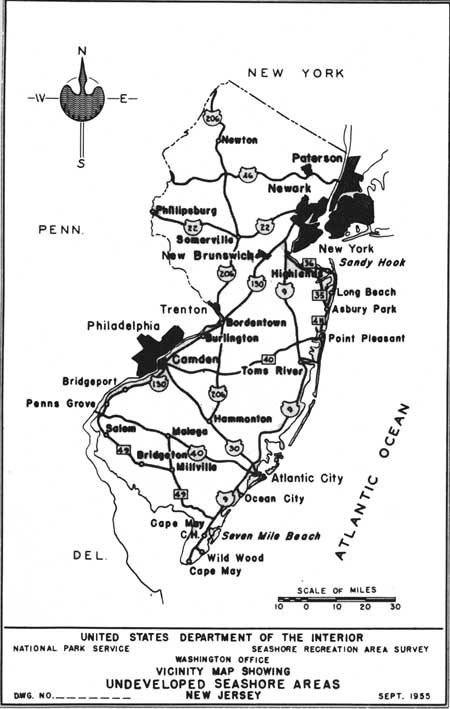
| Undeveloped Seashore Areas of New Jersey (Vicinity Map) (click on image for an enlargement in a new window) |
Little Egg Harbor Area
New Jersey
| Location: | The beaches and harbor of Brigantine Inlet in the vicinity of Beach Haven. |
| Accessibility: | By paved road to below Beach Haven; by boat to other portions. |
| Description of Area: | Considered the most valuable coastal marsh area along the Atlantic coast. It is the wintering grounds of the Atlantic brant and contains the largest colony of laughing gulls along the east coast. The beaches to the north and south of Brigantine Inlet are about five miles in length. The undeveloped portions of the beaches are washed over and unstable. A study is being made by the Corps of Engineers to determine the rate of erosion and probable cost of stabilization of this section of the seashore. |
| Present Use: | A portion of the coastal marsh area is under the administration of the Fish and Wildlife Service. The southern terminus of Long Beach is privately owned and the beach south of Brigantine Inlet is owned by the Borough of Brigantine. |
| Analysis: | The area should be preserved because of its outstanding biological values. The northern portion of this area is now under consideration for addition to the Brigantine Wildlife Refuge and is admirably suited for that purpose. |

|
| Beach Haven, Long Beach |

|
| Brigantine Inlet North |
Seven Mile Beach
New Jersey
| Location: | Portion of the barrier reef between Avalon and Stone Harbor. |
| Accessibility: | By paved road. |
| Description of Area: | There are 2-1/2 miles of undeveloped beach, from 100 to 200 feet wide. The sand is clean but dark, and the beach area slopes rather steeply into the water. The dunes are numerous and stable, and some reach 25 feet in height. The bird sanctuary within the Borough of Stone Harbor is of great scientific importance because of a heron rookery and because the biotic community is typical of plant and animal life as it existed on the strand before human habitation. |
| Present Use: | There are occasional residences and some evidence of real estate promotion. |
| Analysis: | If the communities of Avalon and Stone Harbor expand, they will encroach upon the undeveloped area which lies between them. This procedure seems inevitable. |

|
| Bird Sanctuary, Stone Harbor |

|
| Seven Mile Beach |
Sandy Hook
New Jersey
| Location: | Northern terminus of long barrier reef extending from Long Branch to north of Highlands. |
| Accessibility: | By paved roads. |
| Description of Area: | One of the best areas within the metropolitan zone of greater New York and the New Jersey cities of this vicinity. Its four types of biotic communities--beach grass, shrub, forest, and salt marsh--are as typical and as nearly natural as any in New Jersey. They contain a good variety of plant species including American holly and beach plum. There is a coast line of about 13 miles on both the Atlantic Ocean and Sandy Hook Bay. The beach is 200 to 300 feet wide and somewhat steeply sloping into the water. The sand is light-colored, clean, hard and fine. |
| Present Use: | The entire peninsula is a United States Military Reservation of great strategic importance to the defense of New York. |
| Analysis: | Its importance to the military precludes the possibility of its use for recreational purposes at the present time. Its value as a public recreation area should never be dismissed, however, and it should eventually be put to this use when circumstances permit. |
New Jersey
Conaskonk Point
A 267-acre triangular plot of land thrusting northwardly into Raritan Bay. The land is low, marshy, and subject to partial tidal inundation. The beach is narrow, about 8,000 feet long, and is littered with driftwood and other debris. There are no sand dunes or shrub or forest communities, and the water appears to carry some pollution.

|
| Beach at Conaskonk Point |
Seabright Beach
A narrow, 4,000-foot long, portion of a barrier reef extending from Sandy Hook to Long Branch. The beach area is barren of vegetation and the small amount of undeveloped land remaining is gradually being replaced by residential properties.
Long Branch Beach
An extremely small piece of land close to the city of Long Branch completely surrounded by residential developments and void of sand dunes and vegetative cover.
Manasquan
A strip of coastal shoreline, about 2,400 feet in length, south of Sea Girt and north of Manasquan. The remaining small portion of undeveloped land is being encroached upon by the two expanding communities.
Long Beach
The undeveloped southern end of Long Beach is a barrier island, about 3,000 feet long and 2,000 feet wide, and contains approximately 150 acres of land. There is some grass, but there are no trees or shrubs. A considerable portion of the beach is inundated at high tide and is unsafe for bathing because of undertow and riptides.
Absecon Inlet Beach
About 260 acres of land are contained in the 1-1/4 miles of undeveloped beach on the southern tip of Brigantine Beach. The beach is clean and wide but subject to severe erosion. Corrective measures to date have failed to stop this erosion. Tides flowing through Absecon Inlet cause the beach to be unsafe for bathing. If erosion is controlled the area will undoubtedly be developed by the Borough of Brigantine.
Corson Inlet Beaches
North and south of Corson Inlet are two undeveloped beach areas. The north beach is about 3,000 feet long and the south beach about 1,000 feet. Together the beaches comprise approximately 100 acres of land, portions of which are subject to tidal inundation. There is little vegetation on the areas. Because of currents through the inlet, the possibility of undertow and riptides exists, placing a questionable value on the usefulness of the areas for bathing purposes.

|
| Corson Inlet |
Ludlam Beach
A mile-long beach lying between Sea Isle City and Townsend Inlet which possesses some vegetation and generally stable dunes. The beach is from 200 to 300 feet wide, but dips somewhat steeply into the water. The beach is being constricted by the expanding growth of the two cities and, it can be assumed, will be absorbed by them.

|
| Ludlam Beach |
Hereford Inlet Beach
The southern end of the barrier reef that extends from Townsend Inlet to Hereford Inlet is undeveloped. The 1-mile of beach contains an excellent example of the original plant-animal community typical of the New Jersey coast. In addition, a bird sanctuary, which has been set aside by the community of Stone Harbor, is a portion of this area. The sanctuary and as much buffer area as possible should be preserved in public ownership. The lower portion of the beach is low, marshy and subject to erosion. It could serve as a community public beach area.
Two Mile Beach
There are two miles of undeveloped beach at the southern end of the barrier reef that lies between Hereford Inlet and Cape May Inlet. The beach is wide, flat and clean. Sand dunes are numerous, low and stable. The entire area has a good cover of grass and shrubs and on the southern portion there is a long, narrow grove of good sized trees. It is reported the area is being held by a development company and it is presumed that the community of Wild-Crest will expand in the direction of the beach area.

|
| Two Mile Beach, Stone Harbor |
South Cape May
This area is a portion of the coastal headland of Cape May that lies between Cape May Point and the community of Cape May. There are about 7,000 feet of shoreline along the Atlantic coast. The beach is narrow, dark-stained and littered. The dunes are low and unstable.

|
| South Cape May |
West Cape May
The area is located near the southernmost tip of New Jersey on the western, or Delaware Bay, side. It is roughly square in shape, about a mile long on each of its four sides. The beach is narrow and the sand dark but clean. The dunes are more like ridges and appear to be stable. A larger portion of the area is gently rolling, partly forested and partly farmed. The remaining portion is low and swampy, providing a favorable wildlife habitat.
| <<< Previous | <<< Contents>>> | Next >>> |
rec_area_survey/ag/nj.htm
Last Updated: 25-Jun-2007