|
NATIONAL PARK SERVICE
Atlantic and Gulf Coasts Recreation Area Survey |

|
UNDEVELOPED SEASHORE AREAS IN RHODE ISLAND AND CONNECTICUT

|
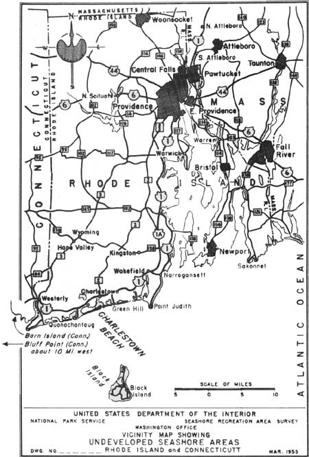
| Undeveloped Seashore Areas of Rhode Island and Connecticut (Vicinity Map) (click on image for an enlargement in a new window) |
Charlestown Beach
Rhode Island
| Location: | A barrier reef, between Quonochontaug and Green Hill, Rhode Island. |
| Accessibility: | By car, off U. S. Highway 1. |
| Description of Area: | A 5-mile barrier reef, Charlestown Beach has an average width of 400 yards and is almost barren of vegetation. The salt ponds between the beach and the mainland are biologically interesting because of the large numbers of aquatic plants and animals. The beach is mostly wide, gently sloping, and contains considerable gravel. The foreshore varies in slope, and there is evidence of undertow activity. Dunes appear intermittently and, at times, reach 20 feet in height. |
| Present Use: | Prior to the hurricanes of 1938 and 1954, it was developed and used by its many owners as a summer resort area. |
| Analysis: | The Governor of Rhode Island has requested an appropriation from the legislature (1955) for the purchase of 2 miles of beach front (at Misquamicut and East Matunuck), outside the boundaries outlined above. These areas were badly hit by the 1954 hurricanes. The State will, no doubt, enter into negotiations for the Charlestown area sometime in the future, and thus tie together in one unit the desired beach frontage. |
 
|
| Charlestown Beach |
Connecticut
Barn Island
A peninsula, about 2 miles long and over 1 mile wide, containing approximately 1,600 acres of low marshy land and wooded upland, which lies on the coast of Connecticut near the Rhode Island Connecticut line, south of Pawcatuck, Connecticut. Its shores are stony and the water is polluted. The area is under the administration of the State Game Commission. If industrial waste can be eliminated from the Pawcatuck River, a portion of the shoreline could be adapted for public recreation use.

|
| Barn Island |
Bluff Point (Mumford Point)
A peninsula, approximately 1-1/2 miles long, 1/2 mile wide, on the coast of Connecticut, 3 miles southeast of Groton, containing about 550 acres of partially wooded land and beach. It contains a fine cattail swamp and a small forest with oaks, hickory, beech, hornbeam, and hawthorn being the most prominent trees. The beach is pebbly and backed up by low, eroding rock outcroppings, and sand and boulder cliffs. It is privately owned, has little development and is easily accessible from large centers of population. The State has had this area under consideration for acquisition for some time.

|
| Bluff Point |
| <<< Previous | <<< Contents>>> | Next >>> |
rec_area_survey/ag/ri-ct.htm
Last Updated: 25-Jun-2007