|
Shoshone National Forest |
|
RECREATIONAL USE AND VALUES
No single activity of the forest has grown so rapidly in recent years as recreation. The forest is ideally adapted to recreational use because of the rough, majestic, and undeveloped character of its wilderness where most travel must be done with a horse and pack outfit. It is truly a forest with a "back country." The numerous lakes and mountain streams, the glaciers, the vast forest cover, and the abundance of fish and game are attractions that draw large numbers of people who wish to see wilderness areas unspoiled by the hand of man.
WILDERNESS AREAS.—Two wilderness areas—the North Absaroka, containing about 380,000 acres, and the South Absaroka, containing about 600,000 acres—have been set aside to insure the perpetuation of the delightful natural and virgin conditions characteristic of the back country in the Shoshone. Entirely undeveloped, except for horse trails and occasional sanitation facilities at camp sites, primeval conditions are comparable to those encountered when John Colter traveled through this country in the early years of the nineteenth century. No roads will be permitted nor will there be any hotels, resorts, or summer homes. Sales of timber will not be made, but the grazing of domestic stock—cattle, horses, and sheep—will be allowed under well-regulated conditions, insuring ample range for big game animals and the protection of the basic soil and water resources.
These wilderness areas and the wildlife and fishing resources of the forest are the basis for one of northwestern Wyoming's principal industries—dude ranching. Within and adjacent to the Shoshone are more than 30 such ranches and similar resorts. Guests enjoy all of the sports common in the mountains—fishing, hunting, hiking, or riding delightful trails. As the cool of the evening descends, they enjoy sitting before a glowing camp fire to hear yarns of the West. These ranches and resorts have various types of accommodations for overnight or weekend guests, camping parties, pack trips, or family groups. Hundreds of guests visit them annually, and go home with tanned faces and a spring in their step.
Within the forest are two main highways which offer splendid scenery to those who do not have the time or inclination to get into the back country with horses and pack outfits.
|
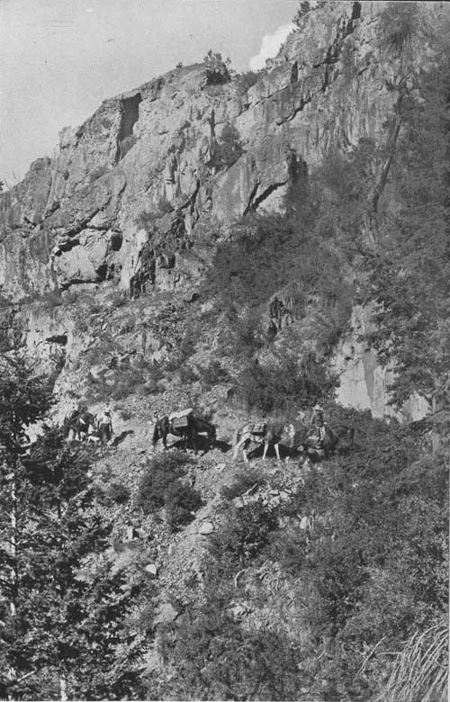
| A pack string on the South Fork Trail. F—385960 |
Along the North Fork.—The Cody Road to the Yellowstone National Park, U. S. 20, winds its way along the banks of the North Fork of the Shoshone River. The forest boundary is 25 miles west of Cody, and on the way, such interesting features as DeMaris Hot Springs, extinct geyser cones and craters, the Shoshone Dam, the tunnels, the Shoshone Cavern National Monument, and typical western stock and dude ranches and resorts can be visited. At the boundary the character of the country changes. The canyon becomes narrower, and here on either side, Signal Peak and Flag Peak, like the Pillars of Hercules, guard the entrance. From this point to the east entrance of Yellowstone Park, the distance is 27 miles.
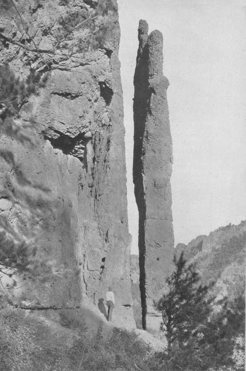
Within the forest, the road passes through livestock and game ranges, heavily timbered watersheds, with active timber sales in progress, and extensively used recreation areas. Thus the tourist is given an opportunity to actually see the coordinated activities of a national forest. Watch for the Laughing Pig, the Camel, the Holy City, the Goose, the Anvil, Henry Ford, Chimney Rock, the Elephant Head, and other figures carved from rock by the hand of nature.
Along the way there are a number of dude ranches and resorts where accommodations may be had, also gasoline stations and stores. At frequent intervals there are picnic and campgrounds for the use of tourists. These are:
| Name | Miles from Cody |
Miles from Yellowstone |
| Hanging Rock Campground | 26.8 | 26.2 |
| Horse Creek Campground—Trailers | 28.1 | 24.9 |
| Big Game Campground | 29.1 | 23.9 |
| Wapiti Camp and Picnic Ground | 30.1 | 22.9 |
| Elk Fork Campground | 30.1 | 22.9 |
| Rex Hale Campground | 36.7 | 16.0 |
| Newton Creek Campground—Trailers | 37.5 | 15.5 |
| Eagle Creek Campground | 45.5 | 7.5 |
| Sleeping Giant Campground | 48.9 | 4.1 |
| Three Mile Campground | 49.7 | 3.3 |
| Pahaska Campground—Trailers | 51.0 | 2.0 |
Individual camping stalls, tables, water, and campfire grates are available at all campgrounds.
Beartooth Plateau—Clarks Fork Country.—The Red Lodge-Cooke City Highway, a hard-surfaced road, passes through the most spectacular area in the forest. Leaving Red Lodge, Mont., it follows a southwesterly course along Rock Creek into the Custer National Forest.
Abruptly the highway leaves the creek and turns up the north slope of Beartooth Plateau, and over easy grades zigzags its sinuous way into Wyoming and the Shoshone National Forest and to the very "top of the world." Once on top a breath-taking panorama unexpectedly unfolds before the astonished traveler. Vision is practically unrestricted in any direction because the road is well above timberline. To the east lies the Big Horn Basin, with the Big Horn Mountains in the background; to the south is the Clarks Fork Valley, Sunlight Basin, and still further south the North Fork and South Fork valleys of the Shoshone. As far as one can see, rugged snowcapped mountains pierce the sky. In the west, Pilot Peak and its Siamese twin, Index Peak, point the way into the heavens. To the north is a continuation of Beartooth Plateau into the Custer Forest which contains grasshopper glaciers and the "land of the red snows." Everywhere evidences of glaciation and tremendous expanses of barren rock are to be seen. Snowbanks are common. Numerous lakes of various sizes nestle in the pockets of the land. Gradually, as the traveler goes westward, he descends to timberline, where gnarled, stunted trees carry on an age-old struggle for existence against the fierce elements of cold driving snows and terrific winds. Further westward as altitude is lost the timber becomes taller, until as one nears the Clarks Fork River dense, thrifty stands are the rule.
Aside from two dude ranches along the road, the only other accommodations within the forest are at Beartooth Lake. Here also are a store, filling station, and picture studio.
The Shoshone National Forest campgrounds along this road are:
| Name | Miles from Cooke City |
Miles from Red Lodge |
| Crazy Creek Campground | 10.8 | 54 |
| Beartooth Lake Campground | 22.9 | 41.9 |
| Island Lake Campground | 26.0 | 38.8 |
Sunlight Basin.—There is also a third road, unimproved, which in good weather affords a real treat to the auto tourist. It leads from Cody over Dead Indian Hill into Sunlight Basin and the upper Clarks Fork Valley. This road is delightfully scenic and connects with the Red Lodge-Cooke City Highway just below the Nordquist ranch. There are two campgrounds along this route, one where the road crosses Dead Indian Creek and the other at the Sunlight Creek crossing. The road leads to excellent fishing in Dead Indian Creek, Sunlight Creek, the Clarks Fork River, and the waters on Beartooth Plateau. It is the shortest route to Beartooth Plateau from Cody.
|
| Chimney Rock—along the Cody-Yellowstone Highway. F—385967 |
| <<< Previous | <<< Contents>>> | Next >>> |
|
handbooks/shoshone/sec4.htm Last Updated: 19-Nov-2010 |