|
Senate Document 84 Message from the President of the United States Transmitting A Report of the Secretary of Agriculture in Relation to the Forests, Rivers, and Mountains of the Southern Appalachian Region |
|
By ARTHUR KEITH.
|
That portion of the Southern Appalachian Mountains in which it is proposed to make a national park lies mainly in North Carolina, but comprises also small portions of South Carolina, Georgia, Tennessee, and Virginia. The area, as a whole, covers about 12,000 square miles, large portions of which are specially adapted to the purposes of a park. This region can be reached within a day's journey from the large cities east of the Mississippi, a measure of accessibility possessed by no other similar district in the United States. It is also nearer the center of population than any other mountain district.
| |||||
|
Magnitude of the mountains. |
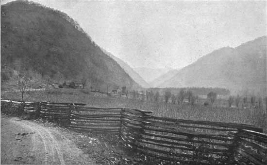
Although this region contains many large rivers and important valleys, it is preeminently a region of mountains. It includes the largest areas of land over 5,000 feet in height east of the Mississippi. In all, 46 peaks a mile or more apart and 41 miles of divide rise above 6,000 feet, while 288 peaks and 300 miles of divide are 5,000 feet or more in height. From the southeastern foot of this mass the Piedmont Plateau stretches southeastward with small interruptions, finally merging into the coastal plain which borders the Atlantic. Past its northwestern foot sweep the valleys of Tennessee and Virginia, with their included ridges and smaller mountains. The great mountain mass thus limited is composed of a number of large and many lesser chains, forming a belt over 300 miles long. Between the chains are extensive plateaus, which are themselves mountains when compared with the lower valleys that dissect them. The Blue Ridge forms the southeastern and the Unaka Mountains the northwestern front of the mountains. Seventy miles apart in North Carolina, they inclose many other extensive ranges between them. In Georgia they approach within 30 miles of each other, and in lower Virginia they coalesce. (Pl. LXV.) | ||||
|
Blue Ridge. |
The southeastern portion of the mountainous area is the Blue Ridge, a sinuous divide which parts the waters of the Atlantic and the Mississippi. The Blue Ridge stands above 3,000 feet in height, except in a number of deep gaps and a short stretch at the head of Broad River. The northern part of the Blue Ridge consists of ancient plateaus, whose summits are broad and gently rolling and rise to similar heights for long distances. From place to place these vary between 3,100 and 3,800 feet. Less regularity prevails in the southern part of the chain, upon which are situated a few individual peaks and ridges of commanding height. Chief of these are Grandfather Mountain, 5,964 feet, Pinnacle, 5,693 feet, and Standing Indian, 5,562 feet. Four other points exceed 5,000 feet in height. South of the Little Tennessee Basin the Blue Ridge becomes exceedingly irregular, both in height and direction, and finally merges into the Piedmont Plateau. The one feature which distinguishes the Blue Ridge from other Appalachian Mountains is its steep slope on the southeast. This is so extreme as to be, in places, precipitous, and it fronts the adjoining foothills and the Piedmont Plateau like a rampart. (Pls. LVIII, LIX.) | ||||
| |||||
|
The Unaka Mountains. |
Roughly parallel to the Blue Ridge and bordering the Great Valley of Tennessee and Virginia lie a series of high mountains which have many features in common and arise from the same causes, although they have separate names. These begin at the southwest with the Unaka Mountains and are continued in the Great Smoky, the Bald, the Unaka, and the Iron mountains. This northwestern front of the mountain mass is termed, collectively, the "Unaka Mountains," a name which is also applied to two of its parts. In the Smoky Mountains several points are but a few feet less in altitude than Mount Mitchell—for instance, Mount Guyot, 6,636 feet, and Clingmans Dome, 6,619 feet. From this maximum in the Smokies the Unakas have progressively lower summits in all directions. Cut apart as the segments of the chain are by the rivers, no average elevations can be stated. South of Big Pigeon River most of the summits are above 5,000 feet. North of that river few exceed 5,000 feet, but many are over 4,000. In all, 125 of its summits rise above 5,000 feet, and 10 exceed 6,000 feet. The body of high land in the Smoky Mountains is the greatest in the Appalachians. | ||||
|
Transverse mountain ranges. |
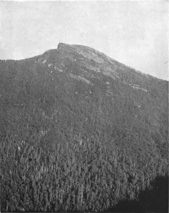
Connecting the Unaka Mountains with the Blue Ridge are a series of more or less interrupted chains, most of which have a northwest direction. Chief of these are Tusquitee, Cheoah, Nantahala, Cowee, Balsam, Pisgah, New Found, Black, Yellow, Roan, Beech, and Stone mountains. Supporting and extending these are scores of smaller peaks and ridges. Here and there on these separate chains are many high points comparable with or exceeding those of the Unaka Mountains—for instance, Roan Mountain, 6,313 feet; Richland Balsam, 6,540 feet, and Mount Mitchell, 6,712 feet, the highest point east of the Rockies. As a whole they are much higher than the Blue Ridge, although they exceed the Unakas but little. One hundred and fifty-six summits are over 5,000 feet, and 36 rise over 6,000 feet. The Balsam and Pisgah mountains are the highest of the transverse ranges and form a maximum corresponding to the Smoky Mountains. (Pl. LXI.) Thus, although the Blue Ridge is the watershed of this area, the highest points, excepting Mount Mitchell, are situated in the Unaka Mountains, where are also located the largest bodies of high ground. Accordingly the rivers flow northwest from the Blue Ridge in deeper and deeper channels, until their gorges are overshadowed by the peaks of the Unakas, a mile in height above them. | ||||
| |||||
|
Surface forms. |
Certain types of surface prevail throughout the mountain district. The mountains rest upon a low base, which varies from 1,500 to 2,500 feet in elevation. The rise of 2,000-5,000 feet up to the summits is made between narrow limits, so that the slopes are steep for the most part. Narrow valleys follow the rivers, in places from 2 to 5 miles in width, and with moderate eminences. From their borders rise the mountains, with slopes abruptly changing 20 degrees or more. These have a marked similarity throughout the mountains, whether high or low. The summits are usually rounded, and cliffs only here and there mar the smoothness of the slopes. The general aspect of these mountains is one of flowing curves, and their grandeur is impressed on the observer by their mass rather than by outline.
| ||||
|
Direction of flow in rivers. |
Probably no region in the United States is better watered or better drained than this. Most of the water passes into the Mississippi, through Tennessee River and its tributaries. Chief of these are the Ocoee, Hiwassee, Little Tennessee, Tuckaseegee, Big Pigeon, French Broad, Nolichucky, Watauga, and Holston rivers. These all flow from the Blue Ridge northwestward through the Unaka Mountains and separate that chain into portions which have received individual names. In the northeastern portion of this region the New River, a branch of the Ohio, rises and flows northeastward. Southeastward from the Blue Ridge a large number of rivers flow into the Atlantic. These are the Yadkin, Catawba, Broad, Saluda, and Chatooga rivers. In the northeastern corner of Georgia rises the Chattahoochee, flowing southwestward into the Gulf of Mexico. Thus this region distributes its waters in all directions and is practically the apex of the drainage of many thousand square miles. From the Blue Ridge near Blowing Rock the waters may run through Watauga River into the Tennessee, through New River into the Ohio, or through the Catawba and the Yadkin into the Atlantic. From the Blue Ridge near the head of Hiwassee River they may flow through Chatooga River into the Atlantic, through the Chattahoochee into the Gulf of Mexico, or through the Hiwassee into the Mississippi. Into these large rivers flow hundreds of lesser rivers and creeks, which cover the country with a most intricate network. They are fed by myriads of springs which run from year to year with unceasing flow. (Pls. LX, LXII, LXIII.) | ||||
| |||||
|
Grades in rivers. |
Starting southeastward from heights of 3,000 feet or more, the streams tumble rapidly from the Blue Ridge and reach the Piedmont Plateau at heights from 1,000 to 1,500 feet. Rivers running in the opposite direction emerge upon the Appalachian Valley at heights from 1,000 to 2,000 feet, the highest points being at the northeast. Few of these rivers flow as far as 100 miles in the mountains, so that this fall of 1,000 or 2,000 feet makes a very high average grade. The stretches of smooth water are seldom long, and the descent is mainly accomplished by countless rapids and minor falls. On the larger rivers few falls exceed 10 feet. Falls of 25 and 30 feet can be found here and there upon the smaller rivers, while in places the creeks and branches have direct plunges as great as 300 feet. That the scenery along the streams is picturesque scarcely needs to be said. From rapid to fall, and then a stretch of placid depth, the courses of the streams are pictures of kaleidoscopic variety. Come to them where you may, the charm is there, and fresh beauties are viewed at every bend. | ||||
|
Volume of flow in rivers. Speed of flow. |
From season to season the rivers vary in flow. Their least volume is in the early fall, when they have been reduced by the droughts and heat of summer. Only the smallest branches are ever entirely dried, however, and the severest droughts fail to stop any considerable stream. The greatest volumes are attained in the spring, when the snows melt rapidly and the winter's accumulation of water is leaving the soil. The freshets are not limited altogether to the spring, however; a cloud-burst, for example, may swell a lesser stream tenfold, or a hard rain of four or five days may flood even the largest river. In the upper courses of the streams, where the grades are highest, floods produce exceedingly swift currents, which are able to destroy obstructions and barriers which at ordinary stages would seem insurmountable. The rapid delivery of the waters from the stream heads make a sudden concentration where the branches have united and the grades are less, causing deep water and overflow. Thus, four days of hard rain recently raised Catawba River 30 feet and overflowed miles of bottom lands. The power of the upper and steeper streams at such times is almost incredible; bowlders tons in weight become mere playthings. On the lower reaches in deeper waters and slackened currents no fragments larger than cobblestones are moved, but wholesale changes in the shapes of the bottom lands are often accomplished. The same steep grades which cause the rapid floods are equally effective when the rains have ceased, so that the waters subside about as quickly as they rise. Aside from these temporary changes in volume the flow of the rivers is very steady, dependent as it is upon the discharge of countless springs and the seepage of waters from the soils.
| ||||
|
Temperature. |
The region covered by this mountain mass possesses a climate which differs greatly from that of the surrounding regions. This is manifest first in lower temperatures and is due directly to the greater altitudes. The peaks, of course, are colder than the intermountain valleys, and both are colder than the adjoining Great Valley or the Piedmont Plateau. The differences in temperature are greater in summer than in winter, so that the climate of the higher portions is more equable than that of the valleys. | ||||
|
Rainfall. |
In addition to the cold which it directly produces, the altitude also affects the climate of this region very decidedly through the precipitation. The prevailing winds of the region are southwesterly and are heavily laden with moisture derived from the Gulf of Mexico. As these winds rise over the mountain slopes they become colder and less able to retain moisture, which comes within the mountain's grasp as rain or snow. The birth of shreds of cloud in the uprising wind and their union into masses that shroud the mountains can be seen on every hand. Through them come glimpses of peak and forest, in a softness and beauty far beyond words. The direct effect of altitude in chilling the winds is assisted by the cooling effect of the almost universal forests. The forests in turn are fostered by the rainfall and humidity, and the two processes go hand in band. In the winter much of the precipitation is in the form of snow. This is protected from melting by the forest cover and accumulates so as to mantle the ground for weeks, or even months. In this way a great store of moisture is retained and finds its way into the soil, to be absorbed in part by the forests when growth begins in the spring. Snow sometimes falls on the higher mountains by the first of October, and the last snow may remain until the middle of March. | ||||
|
Forest cover. |
Between the temperature of the highest tops and that of the larger and lower valleys included in the mountain region there is a great difference. This is expressed in nature most prominently by the great variety of trees, shrubs, and plants. There is probably no region in the United States containing more species than this, which is appropriately termed the "botanist's paradise." During May and June it becomes a vast flower garden of unrivaled rarity and beauty. Rhododendron and azalea bloom mile on mile, or a score of blossoms are trodden at a step. In autumn the purple haze and the blaze of color in the foliage form a panorama that can not be surpassed. The amount of the forest is quite as striking as its variety, and is one of the most impressive features of the mountains. Owing to the warmth and humidity of the atmosphere the individual trees attain great size. White pines reach heights of 200 feet and poplars are 25 feet in girth. Thus, the existence of the forest cover as a whole and of the individual species that are favored by colder climates is dependent upon the altitude, which cools the air and brings moisture to the surface of the earth. Its favorable situation with regard to the moist, warm winds from the Gulf combines with a general altitude unequaled east of the Mississippi to produce a unique and remarkable vegetation. (Pl. LXIV.) | ||||
| |||||
|
The geologic formations which underlie this mountain district may be divided into four large groups. Each differs widely from the others in age, and has very distinct features of its own. These broad differences have expressed themselves in such major topographic features as the Appalachian Valley, the Appalachian Mountains, and the Piedmont Plateau. These differences are also largely responsible for the principal variations in the character of the surface in the mountain district itself. | |||||
|
Limestone group. |
The Appalachian Valley is underlain by a series of limestone stones, shales, and sandstones, mainly of late Cambrian and Silurian age, forming the youngest of the four groups in this region. Small outliers of these formations are included within the area of the mountains near the border of the Appalachian Valley. | ||||
|
Quartzite group. |
The second group occupies the northwestern border of the mountain district, chiefly northeast of the French Broad River. It consists of a series of quartzites, sandstones, conglomerates, and shales of Lower Cambrian age. A second large area of these rocks occupies the Blue Ridge and adjacent territory, nearly in the center of this district. | ||||
|
Conglomerate group. |
The third group is of Cambrian age. It occupies the northwest border of the mountain mass, corresponding in position to the previous group but best developed southwest of the French Broad River in the Smoky and Unaka mountains. The group consists of conglomerates, graywackes, sandstones, schists, and slates, and is called the Ocoee group. This and the preceding two groups were composed of the waste from older rocks, which was deposited under water. The thickness of the strata is approximately the same in the Ocoee group and the formations of the Appalachian Valley. The Lower Cambrian quartzites and shales of the second group have only from one-fourth to one-third of the thickness of either of the preceding groups. | ||||
|
Gneiess group. |
The fourth group is much the largest of all, both in actual bulk and area. It consists in the main of formations of the Archean, or oldest known age. The different rocks include several kinds of granite, diorite, mica-gneiss, hornblende-gneiss, and various schists. A large number of these are of igneous origin, but the original nature of many of the gneisses and schists is unknown. Formations also included in this group are the ancient volcanic rocks. These are developed most prominently in connection with the Cambrian quartzites in the northeastern part of the mountain district.
| ||||
|
Solution of rocks. |
Much of the surface of the Appalachian Mountains is exceedingly ancient. During the later geologic periods it has been subjected to the various natural agencies of destruction and has been worn down according as the rocks presented at the surface were susceptible to these influences. The materials composing these formations are attacked in varying degrees by solution and by chemical processes connected with atmospheric and underground water. Certain minerals—for instance, carbonate of lime—are readily dissolved by natural waters, and the rock in wasting away leaves behind only the less soluble portions in forms of clay. To this capability is directly due the reduction of the Great Valley below the mountain mass. Other minerals—for instance, feldspar—are in part dissolved and in part chemically altered and decomposed by natural waters, so that the coherence of the rock which contains them is largely destroyed. Two groups in this region have a large proportion of feldspar in their makeup, and their surfaces have been gradually lowered by its breaking down. These are the Ocoee group and the Archean group. A third mineral—quartz—is comparatively little changed by solution or chemical action near the surface. Formations made up in large part of this mineral retain their altitudes most persistently and are usually the last to be reduced. This composition is most pronounced in the Lower Cambrian group, but is shared also by the Ocoee group and the Archean group. Although the thickness of the Lower Cambrian quartzites is so much less than that of the other groups, their resistance to solution has caused them to remain upheld in very high ridges and peaks. To this are due the cliffs of Chilhowee, Camp Creek, and Iron mountains and the rugged crags of Grandfather. In the case of the Ocoee and Archean groups their immense thickness and the amount of quartz which they contain have maintained the greatest elevations presented in this region. Of this the mighty domes of the Smokies, the Balsams, and the Roan, and the lofty peaks of the Blacks, are witnesses. (Pl. LXVI.) | ||||
| |||||
|
Rock disintegration. |
The moist atmosphere is conducive to the rapid decay of the rocks, which break up chiefly under the attack of rain, frost, the roots of the trees, the underground waters, and organic acids. At first decay works in along the various partings, resulting in the loosening of large masses, which gradually become smaller, until finally nothing is left of them except clay and the more obdurate bits of rock. The rocks reach the surface only over very small patches, while in places the disintegration attains a depth as great as 50 feet. On sloping surfaces the loose material is maintained in its place solely by friction. When this is lessened or overcome from any cause, the residual matter, be it clay or rock fragments, slides down the slopes until the friction is again sufficient to retain it in one position. Thus are formed immense thicknesses of loose material washed down from steep slopes and accumulated in the hollows and flatter places. This material gradually works its way downhill as it is pushed along by the freezing of the water which it contains, or is rendered more unstable as the water transforms it into mud. Eventually it finds its way into the streams and is carried by slow stages into the sea. (Pl. LXVII.)
| ||||
| |||||
|
Roots and leaves protect the soil. |
The chief agent which checks this process of removal is the forest cover, even though the penetrating roots and the acids due to vegetation induce rock decomposition. These same roots, however, hold the loose material in place and hinder its tendency to slide downhill. With this assistance loose soils are upheld on slopes at angles fully double those which they could maintain unaided. Besides this direct check to the waste of slopes by increased friction, the action of the forests is as great in another way. Loose materials are washed downhill during rainstorms by even the tiniest rivulets. In open fields these gather in a few minutes and form deeper and deeper channels with each succeeding storm, finally removing the loose material down to the bare rock. This process is almost wholly prevented by the network of roots and the cover of leaves, both living and dead, and the water concentrates into rivulets by seeping through the soils so slowly that it carries no sediment. The waters drain off in the hollows and small streams whose channels have been fitted by long use to withstand the attacks of rushing water. | ||||
|
Soil stripped from clearings. |
Countless illustrations of this process can be seen during any rainstorm. Streams which drain considerable areas of cleared land rise fast and become turbid with mud. Those which drain areas protected by forests rise much more slowly, and by comparison the water could be called clear, except in the most violent storms. This result is of course most striking at the very headwaters, the little streams rising in the fields and in the woods. The effects of this work are seen in the innumerable gullies which gash fields left to the elements for any time. In fact, unless checked by the most constant attention, these gullies soon strip off the soil and clay and ruin the fields. In the forests, on the other hand, one rarely sees a slope of soil not covered by vegetation, and it is only along the immediate banks of the streams that raw slopes of loose material are exposed. In short, in this region of deep residual soils the influence of the forest is paramount. It is a fact well known among the mountaineers that the soils are far more fertile when first cleared of timber than ever again. It is equally well known among the farmers along the river bottoms that the same crops have been planted with the same success for scores of years. These latter soils, however, are refreshed from time to time by the overflowing waters, which have swept off fertile materials from the steeper slopes above. The natural fertility of these mountain soils is very great, as is abundantly shown by the tremendous forest growth. The pristine strength of the soil soon wanes in the clearings, and there ensues a loss which is permanent for at least a generation. To convince one's self of the existence of this condition it is only necessary to visit the region. | ||||
|
Storage of water reduced. |
In addition to the loss inflicted by forest cutting upon the steep slopes themselves great damage also results to the lands lying farther down the streams. The deep clays and underlying rocks form a kind of gigantic sponge, which stores up water when it is abundant. When the forests are stripped away the water collects and runs off with vastly greater speed, and much evaporates, so that not only is less stored up, but the discharge is more irregular and temporary. Destructive floods result and droughts are wider spread. Thus, viewed from the standpoint either of utility or beauty, these unrivaled forests are the keystone of the arch. | ||||


| <<< Previous | <<< Contents>>> | Next >>> |
sen_doc_84/appb1.htm
Last Updated: 07-Apr-2008