|
Looking at Prehistory: Indiana's Hoosier National Forest Region, 12,000 B.C. to 1650 |
|
INTRODUCTION
Remains of the first Americans are all around us, on the surface and buried in the ground. For perhaps 14,000 years people lived throughout Indiana, taming the wilderness to suit their needs, building homes, raising children, and establishing important cultural traditions long before Europeans came to the region in the mid-1600's.
Though many people today envision the lives of the First Americans as a very simple existence, archaeological research reveals complex societies, vibrant technical and artistic traditions and, moreover, an understanding of the natural world which rivals our own. Lacking all modern conveniences, Native Americans learned the rhythms of the natural cycles of life by experimentation and observation. Knowledge was carried by elders who taught the wisdom of the ages to the new generations using stories and songs. Unlike people today, prehistoric families made almost everything they needed. If they desired goods and raw materials from far away places, they traveled by canoe and overland trails or traded with neighboring tribes to obtain them.
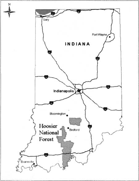
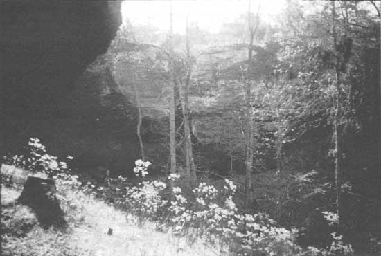
Early peoples who lived within the Hoosier National Forest were little different from people who lived outside the hill country. In fact, many of them came seasonally to the south central Indiana hills to hunt, fish, and collect foods, while living in adjacent areas during other times of the year (Figure 1). Even though the hill country is dissected by deep ravines and ridges and is rugged compared to other parts of Indiana, prehistoric people living in the Hoosier National Forest were never cut-off from their neighbors for any length of time, except perhaps during infrequent heavy snows and floods while enjoying the natural protection and comfort of the many rockshelters (Figure 2). They enjoyed access to trade goods from distant places and took part in new social, political and technological developments. The tools and other artifacts that they left behind for us to discover and study often show connections on many levels to other groups who lived over a wide territory of the Midwest.
|
| Figure 1: Location of USDA Hoosier National Forest lands within Indiana. |
|
| Figure 2: Rockshelter showing alcove, sandstone overhang and slope down from the shelter. |
Within these pages we will explore what is known about prehistoric peoples of the Hoosier National Forest and their cultural traditions, from the time Native Americans first came to southern Indiana until people of European descent arrived and began logging the forest and reshaping the land into family farms.
It is difficult to understand how much people can change over thousands of years, particularly when there is no written record of their lives to document what they experienced and achieved. Archaeologists are interested in many things including tools, items of trade, locations of camps and villages, house construction, plant and animal remains, customs of caring for the deceased, as well as a multitude of other small clues from the prehistoric past. Why? Because these are the tangible remains of past human behavior. Without these physical clues and a reliable way to determine their age, it would be nearly impossible to talk about people in the past in any informed manner.
Owing to the humid climate of this part of the country, many of the things prehistoric people made and used regularly from wood, fiber, animal skins, and even bones, disintegrated a long time ago often due to damp and highly acid soil. Even if some of these happen to be preserved in some unique way, such as dry conditions or special soil chemistry, we are still limited in what we can say confidently about peoples of the past because some important evidence is always missing. For these reasons, archaeologists are like detectives when they collect information from surveys for prehistoric remains on the ground surface and by conducting site excavations. An archaeologist is trained to collect even the smallest bits of evidence, and, for this reason, law enforcement officials often call upon them to look carefully for clues at contemporary crime scenes and collect evidence to help solve mysteries.
The first question often asked upon finding a prehistoric artifact or site is, "how old is it?" Archaeologists today have many ways of answering this question through years of experience in the careful analysis of archaeological sites and with help from other branches of science.
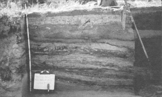
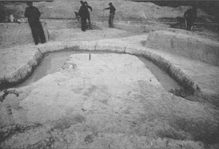
The excavation of an archaeological site that has been inhabited for thousands of years can reveal a sequence of layers that represent different human occupations in the past. This is termed stratigraphy. If there have been no disturbances to the various deposits, continued excavation uncovers progressively older occupations. Sometimes these occupation layers may be separated by one or more layers of sediment that lack signs of human habitation. These layers of sediment can be the result of rock and soil accumulated during a landslide, rocks fallen from the roof of a rockshelter, silt deposited by a flooding river, or dust blown in by the wind (Figure 3). From such a site, one can readily discern the relative age of the occupations from recent ones, which are closest to the surface of the site, to the oldest, found within the deepest layers in the excavation, along with separations due to natural geological events. While the relative age of each layer is recorded, the actual age of the individual human occupations and geological deposits remains unknown.
|
| Figure 3: Soil stratification showing alternating layers of sediment deposited during creek flooding episodes. Prairie Creek site, Daviess County. Indiana University field school, 1975. |
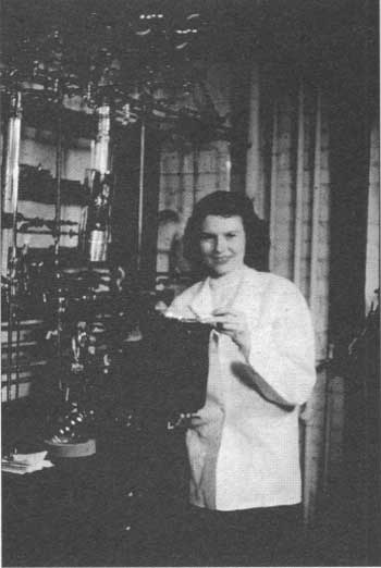
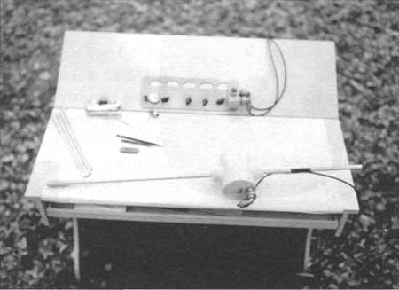
Today there are many ways of determining the age of archaeological finds, but radiocarbon (carbon-14) dating is the main technique used by archaeologists. Radiocarbon is a method by which charred material such as wood, nuts and other organic remains is carefully collected from an archaeological site and then sent to a special laboratory for analysis. The laboratory burns the charred material at a high temperature in a controlled environment and counts the amount of carbon-14 atoms in the gas emitted from the sample. The reason this dating technique is considered reliable is because carbon-14 is absorbed by all living organisms from the atmosphere and everything living at the same time contains essentially the same amount of carbon-14. This dating technique was developed in 1950 by Willard Libby, a chemist, who discovered the rate at which carbon-14 disintegrates when an organism dies. By finding out how much carbon-14 remains in a sample, scientists can calculate how many years have passed since death occurred and obtain a statistical age for the sample (Figure 4).
|
| Figure 4: One of the first radiocarbon laboratories in the 1950's showing some of the equipment used to process charred wood, bone, and other organic samples from archaeological sites and record the carbon gases emitted from the incinerated samples to determine their age. |
Radiocarbon dates are now known for literally thousands of archaeological sites. The samples have been collected from within burned houses, including charred posts and timbers, as well as fire and storage pits, and occupation layers containing charcoal, charred nuts, and other organic matter. Cultural items such as projectile points and pottery found with samples that have been radiocarbon dated are assumed to date to the same age because of their association. Thus, an archaeologist can often pick up a piece of pottery or a projectile point and, after identifying it, can assign an age because the same or similar items have repeatedly been radiocarbon dated to the same time period.
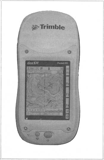
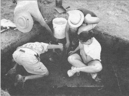
Archaeologists are always looking for new techniques to employ in archaeological surveys and excavations. We need ways in which to make fieldwork easier, less time consuming and more cost-effective. At the same time, we need to record and assess archaeological sites on the surface and within buried layers of soil with greater accuracy and detail. The crew chief of a typical archaeological survey will be in charge of recording on maps the archaeological sites that are discovered and collecting all the relative data, such as the location and size of the site and any existing features or characteristics of the site (Figure 5). The standard maps for hiking in unfamiliar territory and also for plotting a sites location and configuration in space are available from the United States Geological Survey (e.g. USGS quadrangles). One great improvement for locating site's developed in recent years is Global Positioning Systems or GPS, where a hand-held electronic device is used to record a location by signaling with satellites in space (Figure 6). The location of a site recorded in this manner allows accuracy within a few feet. Perhaps the most important advantage of using GPS data comes years later after the initial survey, when a new field crew is attempting to relocate a site in the hilly terrain of the Hoosier National Forest. With the original notes and readings from the first survey, the recorded GPS coordinates can be entered into a GPS handset and quickly reestablish the exact spot where the site was recorded.
|
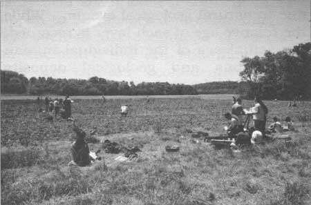
| Figure 5: Students conducting a controlled surface collection on a Martin County archaeological site. Indiana University field school, 1993. |
|
| Figure 6: Handset for GPS (Global Positioning System). The system, which is operated by the United States government, allows the user to link with satellites to locate a precise position on the ground. It is perfect for accurately locating archaeological sites or moving through unfamiliar territory with a variety of maps, including USGS quadrangles, that archaeologists often use. Various handsets are available that provide many options from determining altitude to compass bearings, trip mileage, and travel routes, etc. The handset shown is currently used to locate archaeological sites within the Hoosier National Forest. |
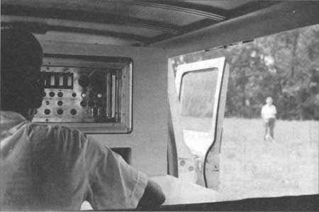
The first professional archaeologist in Indiana, Glenn A. Black, enthusiastically embraced any new scientific equipment that could be used in archaeological field research (Figure 7). One such piece of cutting edge equipment was the proton magnetometer. As the first to use such a device in North American archaeology, Black began mapping the subsurface architectural features of the Angel Mounds site by recording minute changes in the magnetic field of the soil within the upper archaeological zone that were caused by disturbances within the natural soil of the site (Figure 8). The proton magnetometer made it possible to discern anomalies below the surface that had been created by the prehistoric Mississippian inhabitants as much as 1,000 years ago. This included a large wall that had once fortified the town as well as the locations of houses and other features that were not visible on ground surface (Figure 9).
|
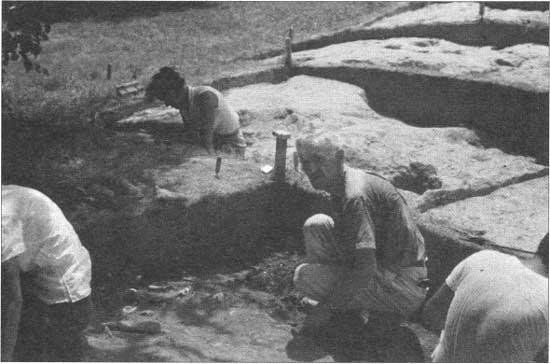
| Figure 7: Glenn A. Black checking a recently excavated concentration of prehistoric Mississippian artifacts and food remains at Angel Mounds State Historic Site. Indiana University field school, 1960. |
|
| Figure 8: Proton Magnetometer in use at Angel Mounds State Historic Site, 1960's. The equipment was heavy and so the main components were installed in a van to transport around the site. |
|
| Figure 9: Excavation of a bastion trench along the outer stockade of Angel site. The stockade once fortified the 100 acre Mississippian town located near Evansville, IN. A proton magnetometer was used to follow and map the stockade and other prehistoric features beyond the areas of excavation. The proton magnetometer recorded high and low electronic signals within the soil that mark the locations where trenches had been dug long ago to insert upright posts for the stockade and also the locations of houses and pits of all kinds. All of the wooden constructions deteriorated with time leaving only stains in the soil and areas of disturbed earth. Circular stains marking the locations of post-molds from the former bastion are obscured in the water and mud from a recent downpour. After sufficient sun to dry the mud, the stains were exposed once again by careful hand-troweling so they could be mapped and recorded. Works Progress Administration (WPA) excavations at Angel Mounds State Historic Site, fall 1940. |
With this early technology, however, the degree of sensitivity was low and it was a slow process to record the data over such a large (100 acre) archaeological site. This technology also did not allow researchers to make critical corrections for variations in magnetic and celestial activity, such as sun spots, which affected the readings from the instruments (Figure 10). Today, magnetometers along with many other types of highly sensitive instruments are often employed in archaeological investigations. All of the equipment and applications for archaeological prospecting come under the heading of remote sensing or geophysics. The Glenn A. Black Laboratory of Archaeology carries on the tradition established by Black by continuing to document the subsurface archaeological features over the entire Angel Mounds site using magnetometry (Figure 11).
|
| Figure 10: Hand instruments used with the proton magnetometer investigations at Angel Mounds. The long device is a probe that was connected to a receiver to transmit signals from the soil to detect prehistoric houses, pits, and other anomalies buried below the ground surface. |
|
| Figure 11: An excavation of a prehistoric house at Angel Mounds with pit features and artifacts identified with a magnetometer. In recent years, remote sensing with a magnetometer has documented many prehistoric houses and interior stockades that were previously unknown. Indiana University field school, 2005. |
Subsurface surveys using remote sensing equipment such as gradiometers, ground penetrating radar, as well as electrical resistivity and conductivity meters and other devices, have all been used in conjunction with surface surveys and, in advance of excavations, to find materials such as concentrations of ceramics, fire-cracked rocks, pits, and hearths. Together, these are called features by archaeologists and they often show up as readings of higher than normal magnetism. The data is downloaded onto computers equipped with sophisticated mapping systems such as GIS (Geographic Information Systems) as well as various other programs. Such equipment, including Global Positioning Systems, has been used with success at prehistoric villages, camps, and other sites across southern Indiana.
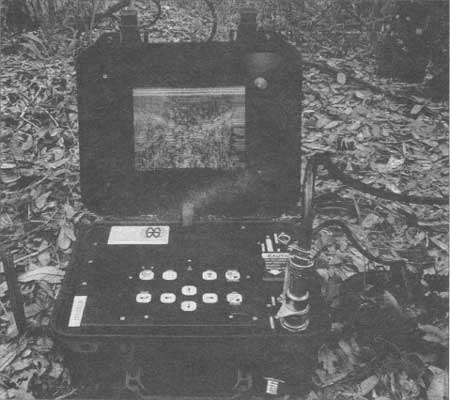
Archaeologists working within the Hoosier National Forest often employ these techniques and systems (Figures 12-13). For example, in advance of test excavations at Indian Cave by archaeologists from Ball State University in 1998, ground penetrating radar (GPR) was used to make a map of the subsurface contexts of the site which was later used to help guide the test excavations of the site which had been impacted by recreational use and looting. Ground penetrating radar helped to find anomalies in the cave sediments before excavation, thereby affording the researchers the advantage of having some insight into the cultural layers, rock fall, disturbances and various sediments they would encounter (Figure 14).
|
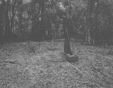
| Figure 12: Close-up of ground penetrating radar instrument (GPR) with display of anomalies identified by the readings. This equipment was used during investigations at Indian Cave by Ball State University in 1997. |
|
| Figure 13: A ground penetrating radar (GPR) hand unit in use over an archaeological site to transmit readings of anomalies below the ground surface back to a receiver. |
|
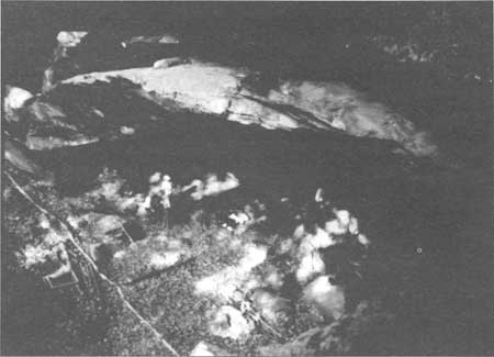
| Figure 14: Beginning excavations at the entrance of Indian Cave. Excavations by Ball State University in 1997 and 1998 found evidence of sporadic occupations spanning the Archaic periods. This is one of the few sites in Indiana where small bits of cordage and squash remains have been identified. However, valuable information was lost due to heavy looting in the upper zones of the site. Archaeologists were unable to continue excavations beneath rock fallen from the collapsed roof and so the true depth of the human occupations is unknown. |
Archaeological excavation, no matter how carefully accomplished and recorded, ultimately destroys the contexts of artifacts and features that it discovers. It is, therefore, encouraging that in the near future various remote sensing techniques will be used to record prehistoric cultural phenomena beneath the ground surface with enough precision that large scale and costly excavations will be unnecessary. With the various sampling techniques now in use, a tremendous amount can be gleaned from small test excavations to verify and sample the cultural features discovered using remote sensing (Figure 15).
|
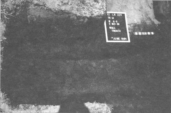
| Figure 15: A small test excavation shows the locations of posts that were once set in the ground as part of a stockade that had long ago surrounded a late prehistoric Oliver phase village. Remote sensing using gradiometer (detects magnetic anomalies) and resistivity equipment (measures a soil's ability to conduct an electrical current) found a number of pits at the site that were rich with artifacts and organic matter. Yet, neither of these devices was successful in detecting the stockade walls. The stockade trench was very narrow and filled with only limited amounts of magnetic materials. Resistivity did detect some of the former walls but the surface area thought to contain the trench was miscalculated. Only a small portion of the trench was detected at the end of the area covered with the remote sensing instrument. Indiana University field school at the Clampitt site, Lawrence County, IN, 1991. |
It is now more important than ever to preserve the cultural integrity of important archaeological sites for the long term. The few remaining archaeological sites must be saved from destruction by development and artifact looting by vandals. It is a federal crime to dig archaeological sites, collect, or disturb artifacts within the Hoosier National Forest or other public and state lands without a permit and an approved research plan. Visitors need to respect the law and help preserve cultural and natural resources on public land by reporting acts of vandalism to archaeological sites and other cultural or natural resources. With support from amateur archaeologists and the public, the archaeological record will be preserved for future generations of Hoosiers.
The archaeological record in Indiana spans at least 12,000 years and perhaps as many as 14,000 years. During such a long time whole cultures, including the language and customs, can change many times. New ideas, ways of viewing the world and making a living evolved; some were maintained for a long time while others changed and some were entirely forgotten with the passing of time. All these cultural changes took place in the wake of people modifying their surroundings, coping with environmental changes, and borrowing from other Native people. Thus, while archaeologists can often say a great deal that is meaningful about these people of the past, we do not know what they called themselves, nor do we know the languages they spoke or the cultural and social groups as they were known to the people themselves.
The terms and names archaeologists use to relate prehistory can be confusing and we will briefly define some of these that will be used within the following chapters. These include "time period", "type", "cluster", "tradition", and "phase".
Various named time periods are typically used by archaeologists as a means of dividing a long sequence of time into smaller units so that developments and changes that take place can be more easily discussed (see Prehistoric Times Periods on inside covers). This also allows changes and developments of one period to be compared with another. The Paleoindian and Archaic time periods, for example, connote lifeways only in very broad terms and these were supplied by archaeologists as a way of discussing what is found in the archaeological record. Thus, archaeologists often refer to Paleoindian or Archaic people(s) or culture(s) as a general way of talking about all human groups living during those time periods. The term "archaic" should not be construed to mean people living during the Archaic period were any less sophisticated or capable than anyone living before or after that time. Many archaeologists simply view the Archaic period as the time after the first Ice Age cultures of the Paleoindian period and before the development of pottery in the Early Woodland period.
Archaeologists define artifact types based on what they look like and how they were made. These are often given the name of the site where they were first defined or given a geographic place name within the area where they were first identified. Thus, projectile points and pottery are known by many defined types. These types are used repeatedly by archaeologists when discussing the past. Clusters are simply groups of projectile point types that date to the same time period, are similar to one another, and have overlapping distributions. The name supplied for the cluster is often that of the best known type within it, which is also often the most common and the one with the widest geographic distribution. By using well-defined type and cluster names for projectile points and pottery types as keys, archaeologists can confidently record the camps and villages of people living over a particular territory, within a given time period, and know many other things about them based on carefully collected evidence. There are a number of books and other reference materials where the reader can get information on all the variations and groupings for prehistoric projectile points and pottery beyond what is covered in the present work.
A tradition is a particular way people behave over a period of time. There are many kinds of traditions (e.g. cultural, religious, ceremonial, political, technological, projectile point, ceramic, hunting, trading, agricultural, etc.). A cultural tradition is the broadest and often includes most of the other kinds of traditions within it. In general discussions, the term tradition can often be equated with people recognizing many common themes that separate them from others. For example, the Crab Orchard tradition is defined for the lower Ohio Valley and the known sites are all recognized by particular types of pottery that occur there and not at other archaeological sites outside the area. It is common to also refer to the sites and artifacts as belonging to the Crab Orchard people or simply Crab Orchard.
The last term I wish to define is phase. A named phase is always defined as part of a named tradition. It represents a smaller unit of people within the tradition, and is based on differences in ceramic types, geography, and other things. Many different phases can be contained within one tradition that spread over a large territory. A good example of this is the Mississippian tradition that is marked by many unifying themes, especially the use of crushed shell in the manufacture of pottery that took place all over the eastern United States between about A.D. 1000 and 1650. However, the people living in the numerous Mississippian towns and villages throughout this large region were probably speaking more than one language with many dialects and were doing many different things locally on a regular basis. Yet, just like Americans today, many tangible things were nonetheless shared between them all.
With the establishment of a phase, we often recognize some particular pottery designs and types, organizational structure and distribution not shared by other named phases. It is also appropriate to equate a phase with particular people. Thus, we can speak of the Angel phase people, who established the large Angel Mounds site near Evansville, just as we can talk about Mississippian societies at Cahokia, East St. Louis, Illinois; Moundville, Alabama; or other prehistoric Mississippian towns across the southeastern United States (Figure 16).
|
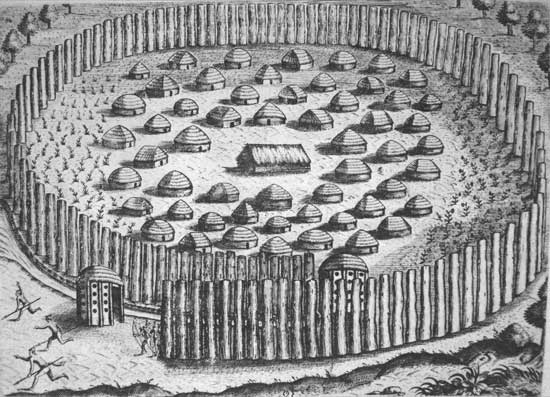
| Figure 16: Native town in Florida showing a stockade and houses with thatched roofs. This is an engraving by Theodore de Bry made in 1591 based on paintings that Jacques le Moyne de Morgues had completed soon after his arrival in the New World in 1564 (From Lorant 1946:95). |
| <<< Previous | <<< Contents>>> | Next >>> |
|
9/hoosier/prehistory/intro.htm Last Updated: 21-Nov-2008 |