

|
Field Division of Education Tuzigoot - The Excavation and Repair of a Ruin on the Verde River near Clarkdale, Arizona |
 |
INTRODUCTION
By Louis R. Caywood and Edward H. Spicer
PREHISTORY OF THE UPPER VERDE REGION
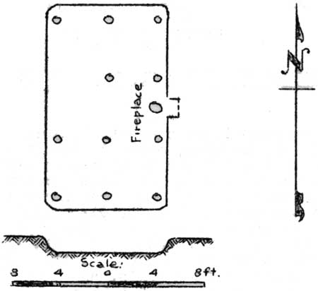
Insofar as we know it at present, history, or prehistory if we must call it that, opens in the Upper Verde Valley on small pithouse communities inhabited by people who had already learned agriculture. One such community was situated on the east bank of the Verde River about three miles north of the present town of Clarkdale. Two of the pithouses were excavated during the winter of 1934 and a few artifacts and potsherds recovered. The houses were oval in form with a vestibule entry on the east side. They had been constructed by making an excavation about eighteen inches deep, lining the bottom and sides of the pit thus made with plaster which became almost as hard as pottery clay, and roofing it over with a framework of poles on which were laid other poles and brush to form perhaps a flat roof with slightly leaning side walls. Figure 1 illustrates all the important structural details insofar as they are known.
|
| Fig. 1. Ground plan of pithouse on east side of the Verde River three miles north of Clarkdale, Arizona. The small circles represent postholes and mark the position of the posts which supported the roof of poles and brush. |
On the floors of the houses were found simple single surface manos and fragments of troughed metates of scoriaceous basalt. The fill of one of the rooms yielded a double handful of charred beans and a few charred kernels of corn. Several very well made obsidian arrowpoints of both stemmed and unstemmed varieties were found near one of the dwellings.
The pottery found in connection with the pithouses gives us a basis for fixing the period during which the pithouses were occupied. Sherds found on the surface in the immediate vicinity of the dwellings are identical with types that have been found and dated in the region of the San Francisco Peaks, Arizona. These have been described under the names Kana-a and Deadman's Black-on-white and Deadman's and Tusayan Black-on-red. With the exception of Tusayan Black-on-red, they have been assigned a time period earlier than 1050 A.D. by the Museum of Northern Arizona.
The pithouse site just described is situated on rolling terrace land bordering a stretch of excellent farm land beside the Verde River. A similar pithouse village, of which a portion of only one floor of one dwelling was uncovered, lies about five miles to the north on the west bank of Sycamore Canyon near the point at which the latter empties into the Verde River. Potsherds found on the surface of this site are of the same early decorated black-on-white types and early decorated black-on-red types as those found at the other pithouse village.
As yet we know almost nothing of the life that the inhabitants of these pithouses led. We have little knowledge of the time at which they existed. We know only that they are earlier than the final great period of Tuzigoot's existence. The pottery types found in connection with them are of the very earliest types found at Tuzigoot. The story that they have to tell will end where the story of Tuzigoot begins. What little we know of the pithouses merely indicates to us what we should look for in the effort to unravel the earlier chapters in the prehistory of the Upper Verde Valley.
UPPER VERDE CLIFF DWELLINGS
Beginning perhaps when pithouses were still in use and lasting until sometime previous to 1300 A.D., there was a period when the important house unit in the Upper Verde region was the small cliff dwelling. During this time the rugged canyons of the tributaries of the Verde River and the cliffs of the river itself were dotted with a tremendous number of masonry walled rooms built in the natural caves and on the limestone and sandstone ledges. The nature of these numerous cliff dwellings can only be made clear by indicating the character of the country in which they occurred.
The Verde River is a perennial stream, flowing at all seasons. It is the main drainage channel for a large section of the Colorado Plateau which forms the northern part of the present state of Arizona. It has cut a precipitous channel at the edge of the plateau for the first twenty miles of its course, from where it heads in Chino Creek as far as Sycamore Canyon. South of this point its valley widens and many areas of bottomlands well adapted for farming occur. On either side of the valley which is as great as two or three miles in width, the land rises to a height of 4000 feet above the river bed. On the west the Jerome Mountains, or Black Hills, with their highest point in Mingus Mountain of 7500 feet, extend from below Camp Verde to south of Perkinsville. On the east rises the rugged edge of the plateau. From the Jerome Mountains on the west no tributaries of any consequence enter the Verde. The important tributaries all enter from the east, cutting their way down off the plateau in deep and torturous canyons. The largest of these in the region which we are considering as the Upper Verde are, from north to south, Hell Canyon, Government Canyon, Sycamore Canyon, and Oak Creek. These tributaries from the north and east have cut the red sandstone edge of the plateau into sheer cliffs, isolated buttes, and steep-walled mesas. It is in the steep walls of these sheer cliffs, buttes, and mesas, in natural caves and on natural ledges, that the cliff dwellings of the Upper Verde region abound.
The Upper Verde Valley from the mouth of Sycamore Canyon to below Camp Verde once, in Tertiary times, contained a vast inland lake. It lay here at the edge of the Colorado Plateau for a period long enough to deposit beds of limestone and sandstone 1500 feet in thickness. Eventually following the destiny of all lakes, the outlet of this inland sea was cut deeply enough to drain the great body of water. The last of its deposits were dropped near the present Camp Verde where calcium sulphate and other salts are now mined and were mined in prehistoric times. Subsequent to the draining of the lake, the old deposits were carved by the Verde and its tributaries into long rounded ridges, small mesas, and cone-shaped peaks, which now as tiny mountains of erosion rise from the floor of the valley to almost uniform heights. They rarely rise more than a hundred or a hundred and fifty feet above the valley floor. It is on these ridges and mesas of white and pinkish lake deposits that many of the larger pueblos of the Upper Verde region occur. Also in their caves and ledges, where they border the Verde, were built cliff and cavate dwellings of the region.
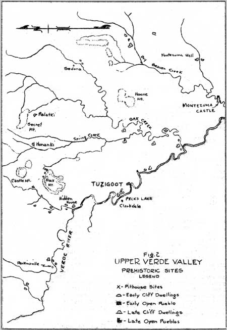
Thirty-seven cliff ruins are indicated on the map of the Upper Verde region included in this report, (Fig. 2). These were visited by Mr. Clarence R. King and the authors during the winter and spring of 1934. Nine of them were mentioned or described by Dr. J.W. Fewkes in his 1907 report on the Upper Verde. It is hardley likely that the thirty-seven sites comprise as much as a third of all the cliff ruins that exist in the area mapped. Cliff sites are tremendously numerous and the country in which they occur is traversed only with difficulty either by horse or afoot. The upper reaches of Sycamore Canyon including Sycamore Basin and Deadman's Pocket, Secret Canyon and Secret Mountain and vicinity, Bell Rock and Lee Mountain, and the region between Sycamore Canyon and Government Canyon, as well as other considerable area will undoubtedly turn out on examination to have been the scene of many cliff dwellings.
|
| Fig. 2 Upper Verde Valley Prehistoric Sites |
It is possible to divide Upper Verde cliff dwellings at present only into two very broad general groups on a chronological basis. The vast majority, thirty-three, of those visited seem not to have been lived in at the time Jeddito Black-on-yellow pottery was in use in the Upper Verde area. At only four of the cliff dwellings visited were sherds of Jeddito Black-on-yellow found: at Honanki, Palatki, the cliff site at the base of Lost Mountain, and. the cavate lodges at the mouth of Oak Creek. These four have therefore been considered to be of a later period than the others; that is, they alone of all the cliff dwellings mapped were occupied as late as 1300 A.D., which is the time set by the Museum of Northern Arizona for the appearance of Jeddito Black-on-yellow. They will therefore be considered below.
All the rest of the cliff sites mapped showed only sherds on the surface of types earlier than Jeddito Black on-yellow. No extended analysis of the small quantity of sherds gathered from them has been made, and thus it will be necessary here to consider them as an undifferentiated group preceding the advent of Jeddito pottery into the Verde Valley and subsequent to the pithouses of the region. The thirty-three sites present in architectural features, in pottery, and in other cultural features noted a fairly homogeneous group. The pottery found at the sites is marked by the presence of decorated types which have been described by the Museum of Northern Arizona as Walnut and Flagstaff Black-on-white, Tusayan Black-on-red, and Tusyan Polychrome. In addition, at most of the sites Prescott Black-on-grey and Tuzigoot Red were found, as well as (at the site mapped at Bear Canyon and the sites on Sycamore Canyon) Prescott Grey ware. These pottery types in the San Francisco Peaks region and in the vicinity of Prescott are known to have been in use between 1050 and 1300 A.D. which period may tentatively be taken as the period during which the small cliff dwellings flourished in the Upper Verde region.
But at the same time that such sites were occupied, small valley and mesa pueblos were also in use, along the Verde and here and there in advantageous spots in the canyons. The largest of any of the open pueblo sites at which no Jeddito ware was found is the one below the large pueblo mapped on Woods Canyon, just below the mouth of Rattlesnake Canyon. There are at least thirty rooms in this pueblo. No other pueblo site at which there was an absence of Jeddito Black-on-yellow has more than 12 ground floor rooms. The small open pueblo on the east bank of Sycamore Canyon about two miles above the mouth has only two rooms. The one on the west bank of the Verde about a mile and a half above Clarkdale has 12 rooms. Others have from two to 12 rooms. Many of the sites are in close connection with small cliff sites and were obviously occupied contemporaneously with the cliff sites. They represent the beginnings of compact pueblo communities in the Upper Verde region. Through chance or through lack of advantageous situation they never developed into large communities. They are the dwellings which were left behind when the great increase in population in the Upper Verde took place about 1300 A.D.
There is little that can be said about these earliest open pueblo sites. No systematic excavation has been carried on in them and what little is known about them is purely a result of surface examination. The same types of decorated pottery, Walnut and Flagstaff Black-on-white and Tusayan Black-on-red and Tusayan Polychrome, that occur in the small cliff dwellings, also are to be found on the surface at the pueblo sites. In addition, at the pueblo sites on Bear Canyon, near Perkinsville, on Sycamore Canyon, at Loy Butte, and on the Verde as far as the mouth of Oak Creek, Prescott Black-on-grey is common. Little else can be said concerning these early pueblo sites.
The characteristic house unit of the period was the small cliff site, a dwelling of from one to 12 rooms, built with in a natural cave or on a natural ledge. The majority of these occur in the rugged walls of the canyons some distance up from the Verde River. The cliffs bordering the river are not, however, without their early cliff dwellings and in them occur some of the largest of the sites. The typical ledge site has already been described by Dr. J.W. Fewkes1. A typical cave site of small extent, Hidden House, has been well described by Mr. C.R. King2. The thirty-three cliff sites mapped, which were earlier than the advent of Jeddito Black-on-yellow, comprise a total of 96 rooms. Because of the characteristic clustering of the small cliff dwellings in certain areas, it might be more correct to consider the thirty-three sites separately mapped as only fourteen sites.
1. Fewkes, J.W. Thirteenth B.A.E. Report, p. 187, 192.
2. King, C.R. An Early Pueblo Burial of the Upper Verde, Rich in Textiles (MS). Mr. King was fortunate enough to find an undisturbed and exceedingly well preserved burial of an important individual in a dry, sandy part of Hidden House, (Fig. 2). The artifacts which accompanied this burial are all on display at the Arizona State Museum, Tucson. The most important item in this collection is a cotton blanket measuring 5'4" x 4'10" completely covered with painted black design elements in step and interlocking key designs.
Their characteristic manner of occurrence, is as follows: A certain area where water was available or where there was a considerable stretch of good farmland will have in its immediate vicinity a great number of cliff dwellings and open pueblo rooms in groups of from one to seven. A typical site consisting of some sixteen separate units occurs on Loy Butte between Loy and Lincoln Canyons, on the butte at the base of which is situated Honanki. Here on the east side of the butte facing Loy Canyon, on the west side facing Lincoln Canyon, and on the top of the butte, scattered in whatever hollows would hold them, there is a total of 29 rooms. They occur in groups of from one to seven. The majority are isolated one room sites. There are five rooms built in the open in different places; the others are cave and ledge dwellings. The area in which these 29 rooms occur is less than a mile long and hardly a quarter of a mile wide. The rooms are situated at all levels up the sides and over the top of the butte. Somewhat similar instances of the scattered occurrence of many cliff and open sites in a small area exist, but on a smaller scale, in other places in the region.
(Web Edition Note: Page 12 is missing in the original document)
and Palatki 18 rooms. The open pueblos, however, are the characteristic villages of the period. Taking the cliff and pueblo sites together there are a total of 708 rooms included in them. This contrasts strongly with a total of 256 rooms for the 52 sites which were earlier than the introduction of Jeddito Black-on-yellow. In the fifteen pueblo sites of the third period there are an approximate total of 650 rooms, which gives us an average of over forty rooms to a site. The majority of the late pueblos actually have in the neighborhood of sixty rooms or more and there are two pueblos on Oak Creek shown on the map which have been estimated to have from 90 to more than a 100 ground floor rooms.
There are probably very few of the large Jeddito period pueblos left out of account in this survey. They were for the most part built along the lower reaches of the tributaries of the Verde out of the more rugged country or in the valley of the Verde itself and for that reason have been readily found and visited. Undoubtedly not all of them are here included, but very few probably remain unfound.
Tuzigoot takes its place in time and character with the large pueblos of the final period in Upper Verde pre-history. It is not the largest of these pueblos, nor in form is it entirely typical. Larger pueblos were situated on Oak Creek. Many of the pueblos were built around rectangular courtyards, as Tuzigoot was not, and not all of them were terraced up the slopes of a hill as was Tuzigoot. But in the main Tuzigoot was typical of its sister pueblos and through examination of it we can perhaps get a graphic picture of the development of large pueblos in the Upper Verde region.
TUZIGOOT, THE SITE
The ruin of Tuzigoot is situated on a ridge of horizontal strata of Verde Lake deposits of impure white limestones and reddish sandstones. The ridge rises steeply from the valley floor for a height of 120 feet. At present the Verde River cuts its channel through the ridge about four hundred yards south of the ruin. In recent geologic times the course of the Verde was blocked by the ridge on which Tuzigoot lies and it made a sharp nothward turn, skirting the ridge and then turning sharply southward again. Since the new channel has been cut, the old bed of the river has become an ox-bow lake which is known today as Peck's Lake. Large areas of the old channel, however, were not covered with water and today, as they did formerly, provide excellent agricultural land.
The name Tuzigoot means "Crooked Lake" or "Crooked Water" and is the Tonto Apache name for Peck's Lake. As far as could be learned, neither the Apache nor the Yavapai of the Clarkdale region had any name for the ruin itself, nor for any of the ruins in the vicinity.
From Tuzigoot one can see, a mile to the northwest another pueblo of about the same size, situated on a similar ridge with an east-west trend. It directly overlooks the Verde on the west and Peck's Lake on the southeast. This ruin has been given the name of Hatalacva, which is the Yavapai name for Peck's Lake.
To the southeast, at a distance of three miles from Tuzigoot, there is visible another ancient ruin on the very summit of a cone-shaped peak of Verde Lake deposits. This pueblo is also of about the same size as Tuzigoot. Like Hatalacva, it was occupied for at least a part of its existence contemporaneously with Tuzigoot. Between the latter and Tuzigoot also on the east bank of the river on a small mesa is still another pueblo which was lived in during the period of the final great years of Tuzigoot.
On the west bank of the Verde, just across the river from Tuzigoot, situated on the southern continuation of the ridge on which Tuzigoot lies a small ruin of perhaps twenty rooms (Plate III, A). Sherds here also indicate contemporaneity with Tuzigoot. Thus Tuzigoot was one of five considerable pueblos included in a very small area in the vicinity of what is now Clarkdale, all of which were at least partially contemporary. The abundant and continuous supply of water furnished by the Verde River and the abundant and excellent agricultural land are the obvious causes of this prehistoric concentration of population in this small area.

|
| Plate III. A (top). The south end or Group V at the start of excavation. The Verde River in the distance. Note the farm lands on either side of the hill which were undoubtedly farmed in prehistoric times. Another small ruin lies on the ridge in the upper right of the picture. B (bottom). After excavation showing the large size of some of the rooms. |
THE PLAN OF EXCAVATION
Before excavation, the clearest evidence of prehistoric occupation of the site consisted of the great number of fragments of rock (Plate III, A) which had been used in the construction of walls. In many places over the summit of the ridge it was possible to distinguish the outlines of rooms. In addition, there were great quantities of pottery fragments, arrowheads, flakes of obsidian and jasper, shells, beads, etc., scattered over the top of the ridge. It was also clear that a great amount of debris had accumulated on the slopes of the ridge below the lowest extent of the rooms on both east and west sides of the pueblo. These refuse accumulation had been dug into by "pot-hunters" and bones and fragments of pottery burial offerings were everywhere scattered about.
With this clear evidence of burials in the refuse the plan of excavation included first the trenching of the east, west, and north slopes below the pueblo with the object of uncovering what burials might be there. Trenches were begun on the east side near the base of the ridge, where no burials were encountered. From a distance of about forty feet below the easternmost rooms burials began to turn up and from this level along the whole eastern slope, trenches were run up the ridge some three feet apart. Burials were encountered to the very edge of the rooms and refuse proved to be at the deepest in occasional places about seven feet.
On the west slope trenches were begun about thirty. feet below what appeared to be the westernmost rooms. Below this point the slope was extremely steep and no debris had accumlated. The trenches, as they advanced toward the summit, revealed a profusion of burials and finally a series of wholly unexpected rooms, buried beneath as much as eleven feet of refuse.
The gentle slopes surrounding the northernmost group of rooms were also trenched. The refuse accumulations here were slight, rarely attaining a depth of two and a half feet, and only one burial was encountered.
|
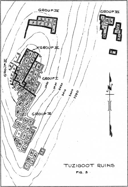
| Fig. 3. Tuzigoot Ruins |
For purposes of field supervision (Fig 3), the ruin was divided into six groups. The boundaries of the groups were arbitrarily selected and bore no relation to the chronological position of rooms. The group numbers and room numbers, within the groups, however, appear on the map of the ruin and for convenience of reference will be used in the description of the architectural features of the pueblo.
Group I was taken to include the burial ground in the refuse slope which extended below the whole length of the east side of the pueblo, in addition to the series of rooms situated just below the crest of the ridge on the east slope.
Group II includes the burial area in the refuse on the west slope and five rooms built below the crest of the ridge on the west slope.
Group III includes all of the rooms situated on the highest part, or crest, of the ridge.
Group IV is made up of the isolated group of rooms to the north of the main part of the pueblo.
Group V includes all the 34 rooms covering the south slope of the ridge.
Group VI includes the isolated group of ten rooms at the base of the east slope immediately below Group IV.
In addition to the uncovering of 411 burials, including both those outside the confines of the pueblo and those within the rooms, the excavation of 86 rooms was carried out, and three blocks of refuse were marked out and carefully trowelled down for stratigraphic information.
GENERAL PLAN OF THE PUEBLO
Tuzigoot was a rambling pueblo, not built or planned as a unit. It was the scene of human life for several centuries. During the period of its occupation rooms fell into ruins and after a time other rooms were built over these ruins. From time to time the central nucleus of rooms was added to. Several times whole groups of rooms were built at once, either directly adjoining the rooms already in existence or at some distance from them. So complicated are the time relations of most of the rooms and so much evidence is there of rebuilding and reutilization of the same space that it is impossible to be certain of the outlines of the pueblo during every stage of its growth.
Spread out along the highest part of the ridge (Plates I and II), the pueblo extends north and south for a distance of about five hundred feet. The greatest width of any sector of rooms is ahout one hundred feet. The rooms, if massed together, would cover about one acre of ground. Leaving aside the isolated unit at the base of the east slope, we find that the rooms were built in continuous terraces up the south and east and west slopes to the summit of the ridge. The lowermost room on the south slope is seventy feet below the highest room at the summit.
The main body of the pueblo is an unbroken mass of rooms 325 feet in length, conforming to the contours of the ridge-top over which it was built. The northernmost group of rooms in this main part of the pueblo were built over the rounded summit of the ridge end their long axes follow the north-south trend of this summit. Below them to the south on a flat shelf was built another group of rooms the walls of which conform to the north-south trend of the shelf. Between these two groups on them slope connecting them, rooms of odd shapes were built in terraces, filling all the space available for satisfactory building.
In addition to the main nucleus of the pueblo there are three more or less isolated groups of rooms. One of these, the southernmost group, was terraced up the slope below the shelf just south of the summit of the ridge. Almost at the base of the east slope there was another group of terraced rooms. To the north of the main group was an isolated unit of seven ground floor rooms built at the northern edge of a flat shelf some twenty feet below the summit of the ridge.
Enclosed between the northern end of the main group of rooms and the northern outlying unit was an open space comprising about 2500 square feet, which had served as a patio or courtyard. Here perhaps daily work as well as ceremonials were carried out. Extending for a distance of at least fifty feet from the westernmost room of the outlying unit was a rough masonry wall, the height of which has not been determined. The wall may have been purely a retaining wall, designed to protect the level patio area from erosion. An alternative explanation for the wall is that it was for defensive purposes. This west side of the patio alone offers easy access to the pueblo. The slope below it is the gentlest of any on any side of the pueblo. The east side of the patio is much steeper and the slopes immediately below all the other parts of the pueblo are very steep. The walls of the rooms of the outlying group themselves would have served as defensive walls to the north. So that the walling of this western side of the patio would have made the pueblo as nearly impregnable as it was possible to make it.
Tuzigoot was a pueblo without general plan, but it was composed of several planned internal units. A large part of the central nuclear group of rooms, the rooms on the southern shelf, and the three outlying groups were obviously planned for the most part as units. But they in turn, after their original construction, were all added to by gradual increment, just as they themselves had been added to the general pueblo as need for more space had arisen.
|
|

|

|
|
|
Last Modified: Monday, May 19 2008 10:00:00 am PDT |