|
HAWAII
Guidebook 1941 |

|
 |
HAWAII NATIONAL PARK HAWAII OPEN ALL YEAR |
|||
|
SILVERSWORD IN HALEAKALA CRATER
| ||||
HAWAII NATIONAL PARK was created by act of Congress, August 1, 1916, and placed under the control of the National Park Service. It consists of two separate tracts of land, the Kilauea-Mauna Loa section, on the Island of Hawaii, and the Haleakala section, on the Island of Maui. It contains 275.71 square miles, the greater portion of which is in the Kilauea-Mauna Loa area.
The park was established to conserve the most spectacular volcanic areas in the United States. Its craters, active and dormant, may be approached with reasonable safety.
KILAUEA
In the Kilauea-Mauna Loa section of Hawaii National Park is the volcano of Kilauea. This volcano, probably older than its neighbor, towering Mauna Loa, creates the impression of being a crater in the side of the higher mountain, although it is itself a mountain with an altitude of 4,090 feet. This illusion is the result of a broad depression at its top and of its gentle slopes, caused by lava flows from many lateral vents. Within the depression is a vast pit, Halemaumau, which often contains a boiling, bubbling mass of molten lava whose surface fluctuates from bottom to rim. Until 1924 molten lava was usually visible at any time in Halemaumau, but activity since then has been spasmodic. Its risings are accompanied by brilliant fountains and inflows of liquid lava, and its lowerings by tremendous avalanches which send up enormous dust clouds.
A century and a half ago, in 1790, Kilauea became unusually active, and its violent blast of ash destroyed a Hawaiian army. Footprints in the volcanic ash are still visible today. Following this great activity, the volcano was inactive for many decades, and no rocks or ash were ejected until 1924.
 1940 FOUNTAIN ACTIVITY, MOKUAWEOWEO CRATER, SUMMIT MAUNA LOA |
During the autumn of 1923 the lake of fire drained away, then gradually returned until the pit contained a 50-acre lake of seething lava. Lava geysers appeared on its surface, sending incandescent sprays 150-feet into the air. In 1924 the lake disappeared and crumbling masses of rock fell into the smoking pit, choking the vents through which the volcanic gases had escaped. A few months later when steam blasts unexpectedly occurred, the vents were cleared by tremendous explosions which hurled boulders and ash thousands of feet into the air. The violent disturbances continued three weeks, by which time the fire pit had been enlarged to four times its former size, the opening being 190 acres in area and 1,200 feet deep. A few weeks later, when all was quiet, a roaring jet of lava appeared at the bottom of the pit, sending up a steady spray 200 feet high, building up a small cinder cone, and forming a 10-acre lava lake on the floor of the pit. In July 1927, a similar display occurred, lasting for two weeks, and in January 1928, the fire returned for one night only. Gas and vapor rise continually.
During 1929 spectacular lava inflows occurred in February and July, raising the floor level 55 and 45 feet, respectively. The pit depth in December 1929, was 1,050 feet and the floor area 48 acres. On November 19, 1930, molten lava again appeared in Halemaumau. Activity continued until December 7. This activity raised the floor of the pit 70 feet; the surface area of the floor then covered 62 acres.
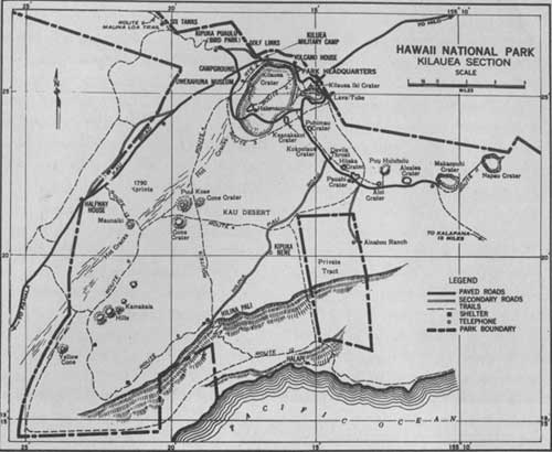
HAWAII NATIONAL PARK (Kilauea Section)
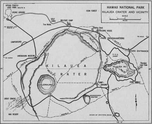
HAWAII NATIONAL PARK (Kilauea Crater and Vicinity)
Following a series of earthquakes, molten lava broke into the bottom of Halemaumau on December 23, 1931. The activity lasted as a spectacular display until January 5, 1932. During the activity the pit was filled to a depth of 100 feet with lava, resulting in a new floor of 88 acres, which was 860 feet below the rim of the pit.
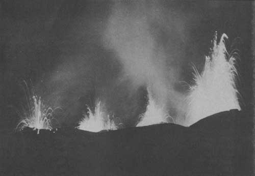
At about 2:45 a. m. on September 6, 1934, without much preliminary warning, molten lava again returned to the fire pit in Kilauea. This eruption in its early stages was one of the most spectacular on record. Highly charged with gas released from tremendous pressure, the frothy lava burst through a crack 700 feet long, half way up the western wall of the crater, cascading in rivers of fire 425 feet to the floor below. The force of the lava cracked open the old floor left by the 1931-32 eruption across its northern and northwest end, and along the foot of the western wall dense clouds of sulphur fumes poured out, as the fiery fountains shot the liquid lava high into the air. As in the previous eruption, blocks of light pumice thrown out from the vents were whirled upward by the heat currents and gales of wind, and deposited in shattered fragments over the land for more than a mile to leeward. In a few days the crater had been filled with new lava to a depth of 70 feet, and instead of the countless frothy fountains of the initial outbreak the activity centered in a lake of fire with from 5 to 10 fountains continuously throwing jets of heavy liquid lava 50 to 200 feet above the lake. The eruption ended on October 8, leaving a new floor of about 95 acres and about 740 feet below the rim.
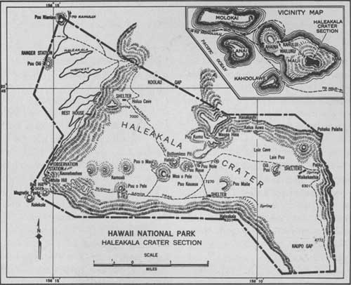
HALEAKALA CRATER SECTION MAP
MAUNA LOA
To the west of Kilauea rises the vast dome of Mauna Loa whose summit crater, Mokuaweoweo, is included in the national park. Included also is a broad connecting belt between the two volcanoes. Mauna Loa thrusts its great bulk 13,680 feet above the surrounding Pacific. By eruptions in its summit crater and flank outbreaks it is constantly adding to its mass.
In action Mauna Loa is even more spectacular than Kilauea; steam vents continually send feathery clouds into the air. Mokuaweoweo and Kilauea are of approximately equal size, but the former is slowly increasing its area by slumping and breaking down of its outer walls. Extending northeast and southwest from the summit are volcanic rifts with many deep rents formed by earthquake and eruption as well as many brilliantly colored spatter cones, some 200 feet in height. These rifts have been the source of most of the recent eruptions, though the summit crater is also frequently active.
Following are major eruptions of Mauna Loa:
1873-74, a summit eruption of 18 months' duration.
1877, a submarine eruption, 1 mile off shore near Kealakekua Bay.
1880-81, a flank eruption of 9 months' duration on the northeast rift, that produced three major lava streams, one to the southward, one to the north in the direction of Kilauea, and the other to the northeast which reached the present limits of the town of Hilo.
1877, a major flow emerged from the southwest rift, that lasted for 10 days, finally reaching the sea about 8 miles northwest of South Point. This is one of the big flows that the main island highway crosses, 40 miles west of the park headquarters.
1899, a flank eruption from the northeast rift.
1919, the Alika flow, from the southwest rift that crossed the highway on the southwest side of the island.
1926, a large flow from the southwest rift that destroyed portions of the Belt Highway in South Kona and the fishing village of Hoopuloa as it reached the sea.
1933, a summit eruption. At this time airplanes were first used to take sightseers over the eruption.
1935, the northeast rift erupted for the first time since 1899, producing a flow that threatened Hilo. The Army Air Corps successfully bombed the upper channels of this flow to divert it before reaching the town.
1940, with no perceptible warning, a 4-mile crack opened extending across the summit crater and a short distance outside to the southwest, in the late evening of April 7. This was a gorgeous display that lasted to midafternoon of April 8, when the fountaining activity concentrated near the southwest center of the crater. This eruption lasted continuously to June 21, and spasmodically until August 20. This is the longest period of summit activity since the eruption of 1873-74.
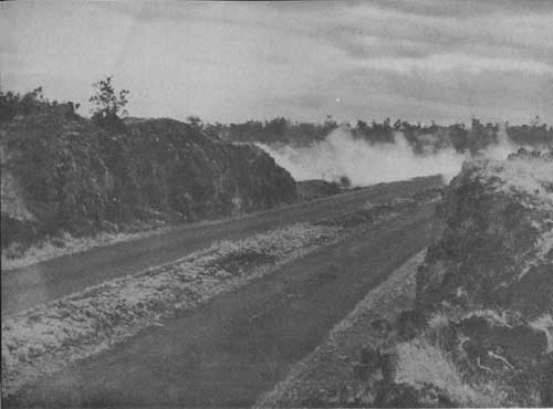 DIVIDED ROAD, STEAMING AREA CHAIN-OF-CRATERS, VICINITY OF ALOI CRATER |
Spectacular and violent as these outbreaks are, they are not dangerous, for there is always plenty of time for onlookers to get to places of safety. In fact, a volcanic eruption in Hawaii is cause for rejoicing rather than fear.
HALEAKALA
The Haleakala section of Hawaii National Park contains one of the world's largest dormant volcanoes. The mountain derives its name, which means "House of the Sun," from a legend about the Polynesian demigod Maui, who climbed to the top of Haleakala, ensnared the rays of the sun, and forced it to travel more slowly in its course so that his mother might have sufficient rime to complete her days work.
Haleakala, now rising more than 10,000 feet above sea level, was once a much higher mountain. A collapse of the dome many years ago formed a great crater 7-1/2-miles long and 3 miles wide, with walls over 1,000 feet high. Within these gorgeously colored walls lies a superb volcanic spectacle. Covering the floor are giant red, black, and orange cinder cones which, though hundreds of feet high, are dwarfed by the immensity of their surrounding. The crater has a circumference of 21 miles and an area of 19 square miles.
After the collapse of the dome volcanic activity continued, and lava flows have poured out from vents in the crater. Explosions have scattered ash, cinder, and debris over the landscape. Great gaps in the crater walls at the southeast and northwest corners were probably caused by these explosions. At the head of these gaps are lovely grassy meadows where from the overtowering walls flow springs of pure water. Dotted with clumps of trees, they are ideal spots for camping. Tanks to gather and store the water from the mountain springs have been erected at various points in the crater and shelter cabins have been constructed.
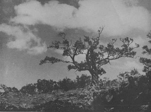
WIND-BLOWN OHIA TREE, VICINITY HILINA PALI
On the walls and within the crater grows the rare silversword plant, a large spherical herb with narrow leaves that gleam like polished silver. The life cycle of this plant is not fully known, but only once does it flower, producing on a stalk 2 to 4 feet high a mass of beautiful purple blossoms. After the seeds have matured, the entire plant generally dies.
While the western slope of Haleakala and a large part of the interior of the crater are arid, and vegetation is scarce, the eastern slopes, where the rainfall is heavy, support a rich plant life. Much of this dense forest region is still virgin and unexplored. Among its many species of plants are large-leafed ape-ape, the greensword, which resembles the silversword, and a peculiar geranium found only on Haleakala.
The beauty of the sunset and sunrise on Haleakala is unforgettable. If fortunate, the visitor at sunset may be privileged to witness the Brocken Spector, a great shadow image, which is really that of the person viewing it. The shadow is usually surrounded by a single halo or rainbow, although as many as seven have been seen.
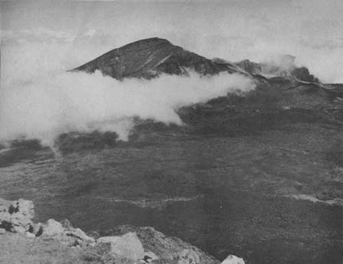 HALEAKALA CRATER FROM OBSERVATION STATION NEAR SUMMIT —Photo by Cunningham. |
ROADS AND TRAILS
Forty-four miles of highway lie within the Kilauea-Mauna Loa section, the main roads being paved. One road leads to the brink of Halemaumau; another winds through twisted koa stands which frame the dome of Mauna Loa and continues up its slopes 6,500 feet. The extremely rough Hilina Pali Road goes to the edge of a 1,000-foot cliff facing the sea; the Chain-of-Craters Road, 7 miles long, skirts a dozen craters lying along the great Puna rift. At Haleakala an excellent road goes to the summit of this crater.
One hundred fifty-nine miles of trail in the Kilauea-Mauna Loa section and 28 miles in the Haleakala section bring many interesting and weird sights to the hiker's eye. In the one section he may walk from the sea to the summit of Mauna Loa; from the Volcano House through rich tropical vegetation, down by way of a fault to the floor of Kilauea; in the other, through the crater of Haleakala from the observation station to Paliku, and thence to the sea through Kaupo Gap or return via other trails across the crater, emerging along the Halemauu Trail near the ranger station.
Before starting any trail trips, hikers should contact park headquarters at Kilauea or the ranger in charge at Haleakala for details, advice, and permits for overnight trips. Permission must be secured for overnight stops at the rest houses. Hikers on overnight trips should always carry a canteen of water, and should inform themselves as to the exact location of the water tanks which have been erected along the trails.
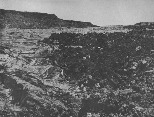
PORTION OF AA FLOW, 1940 ERUPTION, SUMMIT MAUNA LOA
MAUNA LOA TRIP
From the Volcano House to Mokuaweoweo, the summit crater of Mauna Loa, and return is 60 miles. The trip can be made in 3 days either riding or walking.
This is not an easy peak to climb, and to get to the summit is long and exhausting. The climber must exercise moderation in diet; eating often and little will make the trip less arduous. A wool-lined leather jacket and hobbed boots are essential equipment, and leather gloves, smoked glasses, facial creams, lip ointment, and a scarf for the neck are a protection against windburn and sunburn.
All persons intending to ascend Mauna Loa must first register at park headquarters and secure permission to use the rest houses. A fee of 50 cents per person, per night, is charged for use of these rest houses. There is no fee for minors of 16 years, or under, or groups of school children 18 years of age, or under, when accompanied by a responsible adult.
ENTRANCE TO THURSTON LAVA TUBE
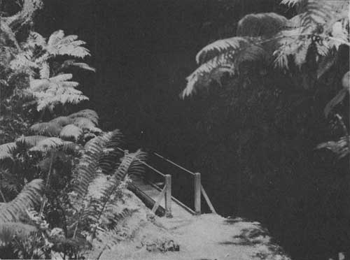
TREES AND SHRUBS
The student of botany will find much to interest him in Hawaii National Park, from the coconut groves of the coast to the stunted ohia trees near the timber line of Mauna Loa. Particularly striking is the tropical vegetation in the Fern Jungle on the road to Kilauea, where giant ferns reach a height of 40 feet, with single fronds 25 feet long arching gracefully over the highway. In this verdant jungle under the canopy of ohia trees, with their greyish-green foliage and brilliant red pompom-like blossoms known as "lehua," the flower of the island, one easily gets the impression of being back in a prehistoric era. In the damp forest regions and along the trails oheloberries grow in abundance.
NATIVE HAWAIIAN BIRDS
The fern jungles, ohia and koa forests of Hawaii National Park, Kilauea section, are inhabited by unique birds, including eight kinds native only to the Island of Hawaii. There are few spots in the Hawaiian Islands today which are as well favored for varied kinds of abundance of Hawaiian birds. Ancient Hawaiians trapped many of these birds and used the scarlet feathers of the iiwi and the yellow feathers of the now extinct mamo for the decoration of war cloaks, or ahuula.
Native perching birds to be seen in forests throughout the park are the apapane, an abundant, colorful bird with red, black, and white markings; the amakihi, a small yellow-green insect gatherer; and the elepaio, or flycatcher, red-brown with black and white markings. The painstaking observer may also find the vermilion iiwi in Kipuka Puaulu with its sickle-shaped red bill and tubular tongue for sucking honey from ohia lehua flowers; the omao, or Hawaii thrush, a songster around the Thurston Lava Tube; or the akiapolaau, with one long and one short mandible for pecking beetles out of wood in the koa groves of Mauna Loa.
On the slopes of Mauna Loa a flock of the nearly extinct Hawaiian goose, or nene, is sometimes seen. The migratory Pacific golden plover, or kolea, winters in the park. Sea birds are the Hawaiian tern, or noio, a graceful, grey bird at the shore cliffs, and the white-tailed tropic bird, or koae, frequently soaring within the crater Halemaumau.
KIPUKA PUAULU
Kipuka Puaulu, a beautiful natural park, also known as Bird Park, is an interesting feature of the Kilauea area. This kipuka, or oasis, has escaped encircling lava flows, and its rich black soil supports a marvelous variety of vegetation. As many as 40 species of trees grow here. This favored spot of 100 acres is the haunt of many beautiful and rare native birds. A nature trail has been established along which the rare trees are plainly marked. A trailside shrine provides additional information.
INTERPRETIVE SERVICES
The research and information facilities maintained by the Government are directed jointly by the principal scientist and park naturalist, from the new Volcano Observatory and Naturalist Building, just across the road from park headquarters and the Volcano House entrance.
The Volcano Observatory, established in 1912, is directed by the principal scientist and operated in cooperation with the Hawaiian Volcano Research Association and the graduate School of Geophysics of the University of Hawaii. A vast amount of research has been and is being conducted, including continuous observations of Kilauea and Mauna Loa, since established. Data concerning earthquakes, tidal waves, and volcanoes are obtained and studied.
Other research work and the information service are under the supervision of the park naturalist. This work is interpreted to the public by scheduled field trips to points of interest, trailside shrines and museums of strategic locations, and illustrated lectures by the various staff members at the central museum in conjunction with demonstration maps, charts, and other exhibits.
Much of the scientific and museum equipment has been donated by the Hawaiian Volcano Research Association and other interested groups.
HUI O PELE
The Hui O Pele is an organization sponsored by the Outdoor Circle of Honolulu and is composed of those who have visited the fire pit, Halemaumau, in the crater of Kilauea, the home of the fire goddess Pele. The life membership fee is $1, and net revenues therefrom are expended for improvements in the park. Among the structures which have been erected are the Uwekahuna lecture hall, the Summit rest house on Mauna Loa, the Footprint Museum shelter, and the shelters at Hilina Pali, Thurston Lava Tube, Halemauu Trail, and other points.
ADMINISTRATION
The park is administered by the National Park Service, United States Department of the Interior, with the Superintendent in immediate charge. The administrative center is in the Kilauea area.
All complaints, suggestions, and requests for information should be addressed to the Superintendent, whose post-office address is Hawaii National Park, Territory of Hawaii.
The superintendent's representative in the Haleakala section is the Ranger-in-Charge, P. O. Box 320, Wailuku, whose office is near the park entrance on the Haleakala Road.
FREE PUBLIC CAMPGROUNDS
Two public automobile camps, where motorists may obtain free wood and water, have been established. Shelter buildings, picnic grounds, fireplaces, and other conveniences are provided at these campgrounds.
ARMY CAMP
In the Kilauea section, 1 mile from the Volcano House, is a rest and recreation camp established for the use of the United States Army and Navy officers and their families, and for the enlisted men. The camp has a well-equipped hospital and post exchange.
ACCOMMODATIONS AND EXPENSES
The only hotel in Hawaii National Park is the Volcano House, located in the Kilauea-Mauna Loa section and operated by George Lycurgus under franchise from the Department of the Interior. Rates for rooms with meals are $5 a day upward, per person. The weekly rate for one person in a room with shower, is $40; other rooms may be had from $25 up. Half rates are charged for children under 8. Special rates are offered for 4 weeks or longer and for two or more persons in a room. Sulphur baths are 50 cents each. Horse rental and guide service are $5 per day each.
The park operator in the Haleakala section, E. J. Walsh, Manager of the Grand Hotel, Wailuku, Maui, also furnishes horses and guide service at the same rates.
This booklet is issued once a year, and the rates mentioned herein may have changed slightly since issuance, but the latest rates approved by the Secretary of the Interior are on file with the park superintendent, the manager of the Volcano House, and the manager of the Grand Hotel.
MISCELLANEOUS SERVICES
Communication Service.—A post office is maintained at the Volcano House, Hawaii, T. H., the year round. Telegrams may be received and sent from the hotel. Telephone and wireless connections can be made with all parts of the world.
Photographic Supplies.—A studio where photographic supplies of every kind may be obtained is adjacent to the Volcano House. It is operated by K. Maehara, who also maintains a laboratory for developing, printing, enlarging, coloring, and framing of pictures or lantern slides.
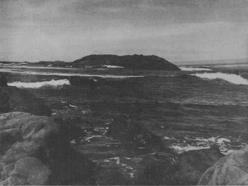
KEAOI ISLAND OFF SOUTH COAST, KILAUEA SECTION
HOW TO REACH THE PARK
Both sections of the park are reached by steamer or airplane from Honolulu. Steamer service to the Kilauea section is twice a week; to the Haleakala section, 6 days a week. Air service is available daily to the Islands of Hawaii and Maui. Minimum steamer rates are $25 round trip between Honolulu and Hilo, port of Hawaii Island, and approximately $16 round trip between Honolulu and Lahaina or Kahului on Maui. Round trip airplane fare between Honolulu and Hilo is $41.50 and between Honolulu and the Maui airport $27. Cars may be rented at the wharves or airports for trips to both sections of the park.
Bus service, operated by K. Hatayama, is available twice daily between Hilo and the Kilauea section. These buses leave Hilo at 9 a. m. and 3 p. m., and leave the park at 12:30 and 4:30 p. m. The fare is 50 cents each way.
For trips to and through the Hawaiian Island, the Hawaii Tourist Bureau, a nonprofit community-advertising and information organization, with offices in Honolulu and 215 Market Street, San Francisco, will supply information.
RULES AND REGULATIONS
[Briefed]
Let no one say, and say it to your shame,
That all was beauty here until you came.
The following summary of rules and regulations is intended as a guide for all park visitors. You are requested to aid the park administration by carefully observing the provisions as outlined:
Preservation of Natural Features.—The first law of a national park is preservation. Disturbance, injury, or destruction in any way of natural features, including trees, flowers, and other vegetation, rocks, and all wildlife is strictly prohibited. A written permit from the superintendent is necessary for picking fruit in any quantity in excess of one gallon. Visitors are cautioned that certain berries are poisonous.
Camps.—Camp or lunch only in designated areas. All rubbish that will burn should be disposed of in campfires. Garbage cans are provided for noninflammable refuse. Wood and water are provided in all campgrounds.
Fires.—Fires are absolutely prohibited except in designated spots. Do not go out of sight of your camp, even for a few moments, without making sure that your fire is either out entirely or being watched. Extinguish completely before leaving camp.
Dogs, Cats, or Other Domestic Animals.—Such animals are prohibited on Government lands within the park except as allowed through permission of the superintendent, secured from park rangers at park headquarters.
Automobiles.—Safe speed limit on the park roads is 35 miles per hour. In the headquarters area a speed limit of 25 miles per hour is rigidly enforced.
Trail Travel.—Hikers and riders shall not make shortcuts but shall confine themselves to the trails at all times. Saddle animals have the right-of-way over pedestrians. The latter will take the outer side of the trail whenever possible and stand quietly until animals have passed.
Hunting.—Hunting within the park boundaries is prohibited. No firearms are allowed except as provided for through permission of the superintendent, secured from park rangers at park headquarters.
Park Rangers.—The rangers are here to help and advise you as well as to enforce the regulations. When in doubt ask a ranger. Help them to serve you better by observing these regulations.
Copies of the complete rules and regulations promulgated by the Secretary of the Interior for the government of the park may be obtained at the office of the superintendent and at other concentration points through the park.
| <<< Previous | <<< Contents>>> |
1941/havo/sec1.htm
Last Updated: 20-Jun-2010