|
LASSEN VOLCANIC
Circular of General Information 1936 |

|
FISHING
There are dozens of lakes and streams in Lassen Volcanic National Park that have been regularly stocked for years and but relatively seldom fished. The great number of lakes, the fact that they have hitherto been rather inaccessible, and the intensive fish-planting program have made this park one of the finest fishing areas in the State. The most numerous species is the rainbow trout. Brown trout, Loch Leven, and eastern brook are also found in abundance. The waters are very cold, and the clean, sandy bottoms of the lakes and plentiful food supply make the trout very fine eating.
All fishing waters in the park are now within an easy half day's hike from some entering road. The completion of the Lassen Peak Loop Highway brought such well-stocked waters as Cluster Lakes, Twin Lakes, Lower Kings Creek, and the White Lakes within easy walking distance from the road. Manzanita and Reflection Lakes usually offer the best fishing on the highway, with Kings Creek, Hat Creek, and Summit Lake good at times. In Manzanita Lake, bait (hellgramites and eggs) is most successful, although at times the trout will rise to flies and spinners very well. In the approximate center of the park are a group of lakes known as the Twin Lakes. They are reached by trail from Summit Lake, going by Echo Lake and thence down the long draw terminating at the upper Twin Lakes. The distance is 3-1/2 miles. The Cluster Lakes also offer good fishing, and are most easily reached by driving to Badger Flat and hiking to the lakes on the marked trail. Distance, 2-1/2 miles. Cluster and Twin Lakes are at their best from the 1st to the middle of July and again from September 15 to October 31.
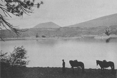
Butte Lake with Cinder Cone in distance. Holmes photo.
In the northeastern section of the park Butte Lake has long been famous for the size of its trout. Near Butte Lake and accessible by trail are Snag and Widow Lakes, two excellent fishing waters.
Perhaps the most consistently good fly lake in the park is Horseshoe Lake. It is reached after a mile hike from the end of the Juniper Lake Road. The Twin Lakes group is not far from Juniper Lake. The best creek fishing is in Warner Valley. Upper Kings Creek may be reached on the Lassen Peak Loop Highway and by trail from Summit Lake.
The trout in park waters will almost always rise to a fly. The wet fly is usually the most successful. The Professor, Black Gnat, Blue Upright, Queen of the Waters, Improved Governor, mosquito, and gray hackle flies are recommended.
In the early spring and throughout the summer an insect known as the hellgramite is found under logs and debris along the edges of many of the park lakes. This insect makes very good bait. Salmon eggs are extensively used, and in the early spring trolling with a no. 2 or 3 spinner is recommended. To prevent carp and other objectionable species from taking over the fishing waters in the park, the use of live bait not obtained in the park is strictly prohibited.
The limit for a day's catch is 10 pounds and 1 fish, with a maximum of 10 fish, and State angling license is required. Where not inconsistent with special park regulations, the fishing laws of the State of California apply and are enforced.
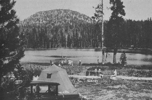
Summit Lake Camp Ground. Holmes photo.
CAMPING
Lassen Volcanic National Park is primarily a campers' park. On the Lassen Peak Loop Highway, three ideal camping spots have been selected, developed, and set aside as free public camp grounds. Summit Lake Camp Ground is the most central to all points, and is excellently located for fishermen who desire to hike to the wilderness lakes. Kings Creek Camp Ground has the advantage of being near Lassen Peak and Bumpas Hell. Manzanita Lake Camp Ground, situated near the northwest entrance to the park, is located beside a good fishing lake, and is convenient to supplies. It is at present the best developed as to conveniences.
While the days are warm, nights are often chilly, and it is well to have plenty of warm bedding. Camp-fire programs are given nightly in the larger camp grounds.
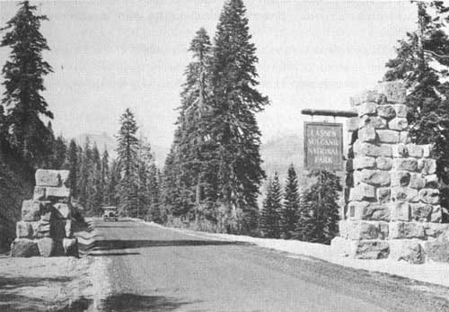
The Raker Memorial Gate on the Lassen Loop Highway. Sager photo.
HOW TO REACH THE PARK
Stages connect with Southern Pacific trains at Red Bluff, Calif., and Reno, Nev., and with the Western Pacific Railroad at Keddie. These stages serve only the Warner Valley and Juniper Lake entrances at this time.
The park may be reached by automobile over all-paved highways from Redding and Red Bluff, on Pacific Highway (U. S. No. 99) and from Reno on the Lincoln Highway. Roads also extend down to the park from the Redding-Alturus lateral at Burney and Pittville. The State highway from Red Bluff to Reno passes within a few miles of the park, connecting with three park entrance roads. Several roads from the south connect with this highway.
High speed, de luxe airplane service from all points in the United States to Reno, Nev., Medford, Oreg., and Sacramento, Calif., is available through United Air Lines. For persons of limited time this provides an excellent opportunity to visit the park.
ADMINISTRATION
The park is administered by the Department of the Interior through the National Park Service, with the superintendent in immediate charge. His office is located at administrative headquarters, one-half mile west of Mineral on the Red Bluff-Susanville State Highway. Maps, information, and bulletins may be obtained there. Address communications for the superintendent to Mineral, via Red Bluff, Calif. Mail for campers and the park utility operator should go to Manzanita Lake, Calif.
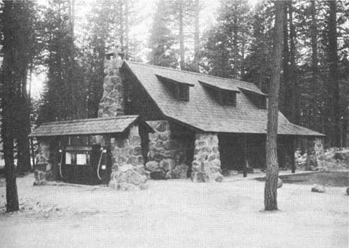
Manzanita Lake Lodge. Loomis photo.
ACCOMMODATIONS AND EXPENSES
Manzanita Lake Lodge is operated by the Lassen National Park Camp, Ltd., under Government supervision. It is a half mile from the Manzanita Lake entrance. Modern housekeeping cabins of a standard and de luxe type may be rented at various rates. Without bedding, kitchen equipment, etc., the charge for one or two persons for a bedroom is $1.50 standard and $1.75 de luxe and $2 and $2.50, respectively, for a bedroom and kitchen. If bedding and kitchen equipment are furnished the rates are $2 standard and $2.25 de luxe for a bedroom and $2.75 and $3, respectively for a bedroom and kitchen. No charge is made for children under 3 years of age; from 3 to 11 years, half rates are charged.
A 10 percent discount is allowed to persons staying a week or more. Rowboats are available at a cost of from 35 cents an hour to $7 a week.
Mrs. B. F. Loomis maintains a photographic shop at Manzanita Lake. Groceries, gasoline, and other supplies may also be purchased at this concentration point.
Mail for guests or campers in this section of the park should be addressed to Manzanita Lake, Calif., and will be held at the post office until called for.
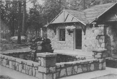
The Loomis photographic shop at Manzanita Lake. Loomis photo.
Juniper Lake and Drakesbad.—These two resorts are located on private lands within the park, and are operated entirely as private enterprises without any supervision by the Government. At Juniper Lake, tent and cabin American-plan accommodations are available at prices ranging from $4 a day to $27.50 a week for one person. Saddle horses are available at $3 a day. Rowboats cost 50 cents an hour and motorboats $1.50. The services of a guide may be obtained for $6 a day. At Drakesbad, in the upper end of Warner Valley near the Devils Kitchen and Boiling Lake, similar accommodations are available at $4 a day or $24 a week, and up. Saddle horses cost $2 a day, and guide service is $5.
This booklet is issued once a year. The rates mentioned herein may have changed slightly since issuance, but the latest rates approved by the Secretary of the Interior are on file with the superintendent and park operator.
INTERESTING PLACES NEAR THE PARK
Subway Cave.—Seventeen miles north of the park, on the Hat Creek Road to Burney, an old lava tube has been discovered. This tube is several hundred feet long, with a flat, level floor, 6 to 25 feet high, and runs through an old lava flow. It can safely be explored with flashlights and makes a very interesting side trip from the park.
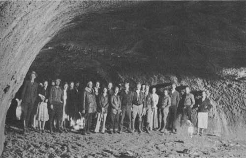
In a Subway Cave, a lava tube 14 miles north of the park. Holmes photo.
Lumber Mill, Westwood.—One mile off of the Red Bluff-Susanville Highway is the town of Westwood, owned and operated by the Red River Lumber Co. This huge mill normally employs several thousand men.
Mount Shasta.—This famous mountain may be seen looming up in the distance from several points along the road to the park from Redding Red Bluff.
Lake Almanor.—Said to be one of the largest of artificial lakes, Lake Almanor has long been known for its excellent trout fishing. The name of this lake was taken from parts of the first names of the three daughters—Alma, May, and Eleanor—of the president of the power company develop the lake.
Lassen Peak Loop Highway.
Foothill Craters.—Several extinct volcanoes—with their characteristic craters, flat tops, and conical shapes—may be seen when passing through the valley foothills. In this same area, where a mass of boulders strews over the acres of land a short distance out of Red Bluff, is broken lava rock carried down in mud flows and landslides from volcanoes higher up. Later the lighter soil surrounding these boulders eroded, with the result that today the ground is covered with thousands of lava blocks.
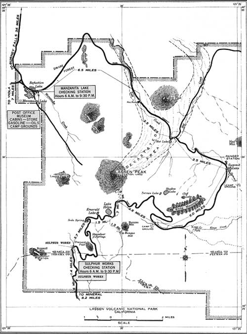
POINTS OF INTEREST—LASSEN PEAK LOOP HIGHWAY
| Miles from southwest entrance |
Name | Remarks | Miles from northwest entrance |
| 0.0 | Southwest Park Boundary. | Raker Memorial Gateway. Elevation, 6,550 feet. Mineral, 8.2 miles. Viola, 36.7 miles. | 29.7 |
| 0.6 | Sulphur Works-Checking Station. | Stop and obtain permit. Firearms must be declared and sealed. | 29.1 |
| 2.0 | Sulphur Works | Steam vents, boilers, mud pots, etc., can be seen from the road. | 27.7 |
| 4.0 | Diamond Peak | The highway from the park boundary to Lake Emerald winds up inside of the old original Brokeoff Crater, one side of it having been broken through by Mill Creek. Rounding Diamond Peak a ragged agglomerate point sticking up in the center, it is often possible to see steam vents in the old crater wall across the canyon and Steamboat Springs in the bottom of Little Hot Springs Valley. | 25.7 |
| 5.7 | Soda Spring | Water considered medicinal. | 24.0 |
| 6.7 | Lake Emerald | Rainbow trout in lake can be seen from bank. | 23.0 |
| 7.1 | Bumpas Hell Trail | Bumpas Hell, one of the largest areas of spectacular hot springs, mud pots, boiling pools, and other types of volcanic activity, is reached from this point by trail, 1.3 miles long. About 2-1/2 hours. | 22.6 |
| 7.2 | Lake Helen | Named after the first white woman to climb Lassen Peak, Helen Tanner Brodt. | 22.5 |
| 7.9 | Lassen Peak Trail | A good trail, 2-1/2 miles in length, to the top of the only recently active volcano in continental United States. About 3 hours. | 21.8 |
| 8.2 | Summit of Highway | Elevation, 8,512 feet. Descending and going east, Lake Almanor and surrounding country are seen in the distance. | 21.5 |
| 12.6 | Kings Creek Meadows | Free public camp ground. Elevation, 7,400 feet. | 17.2 |
| 17.5 | Summit Lake | Excellent camp ground, convenient for hikes, fishing, and to points of interest. | 12.2 |
| 20.0 | Devastated Area | An extensive area denuded of all vegetation by hot blasts and mud flows from the May 1915 eruptions of Lassen Peak. | 9.7 |
| 22.5 | Hot Rock | Large black lava rock carried by mud flow from Lassen Peak. Observers state this rock remained quite warm over a week. | 7.2 |
| 27.5 | Chaos Crags and Chaos Jumbles. | The Chaos Crags are old lava plugs, believed to have been pushed up only 200 years ago, the top of which broke off and avalanched down to form Chaos Jumbles. | 2.2 |
| 29.0 | Manzanita Lake—Educational Headquarters, Post Office, Stores, Lodge. | Mae Loomis Memorial Museum. Free public camp ground; cabins, lunches, groceries, rowboats, gas and oil, photographs, and supplies. | 0.7 |
| 29.4 | Manzanita Lake—Checking Station. | Stop and obtain permit. Declare and have guns sealed. | 0.3 |
| 29.7 | Northwest Park Boundary. | Viola, 6.3 miles. Butte Lake, 30 miles. Mineral, 37.9 miles. | 0.0 |
For information, service, or assistance of any kind, ASK A PARK RANGER. | |||
DISTANCES TO PRINCIPAL PLACES
BY AUTOMOBILE FROM MINERAL, PARK HEADQUARTERS
| To— | Distance between points |
Distance from Mineral | Remarks |
| Manzanita Lake: | Miles | Miles | |
| Park boundary | 8.2 | 8.2 | Elevation, 6,300 feet; declare guns. |
| Summit | 8.2 | 16.4 | Elevation, 8,512 feet |
| Manzanita Lake | 20.8 | 37.2 | Museum, cabins, store, gas, camping. |
| Park boundary | .8 | 37.9 | Road continues on to Redding and Red Bluff, to Hat Creek, and to Butte Lake. |
| Warner Valley (Devils Kitchen and Boiling Lake): | |||
| Chester | 32 | 32 | Red River Lumber Co. holdings. |
| Lee Camp | 12 | 44 | Resort accommodations. |
| Kelly Camp | 2 | 46 | Do. |
| Ranger Station | .5 | 46.5 | Park boundary, information, maps. |
| Drakesbad (Warner Valley). | 2.5 | 49 | Resort accommodations (private land); 25 cents charge for nonpatrons. |
| Juniper Lake: | |||
| Chester | 32 | 32 | |
| Juniper Lake Camp Ground. | 11 | 43 | On south shore of Juniper Lake. |
| Juniper Lake Resort | 1 | 44 | Resort accommodations (private land). |
| Butte Lake: | |||
| Chester | 32 | 32 | |
| Westwood | 13 | 45 | Turn right on Pittville Road. |
| Park boundary | 45 | 90 | 12 miles of rough, dangerous road. |
| Butte Lake | 2 | 92 | Good fishing, Cinder Cone (via trail) 2 miles. |
| Butte Lake via Lassen Loop Highway: | |||
| Park boundary | 8.2 | 8.2 | See Mineral to Manzanita Lake. |
| Summit | 16.4 | 16.4 | Elevation 8,512 feet |
| Manzanita Lake | 37.2 | 37.2 | Educational headquarters. |
| Old station | 13.3 | 50.5 | Store, gasoline, post office. |
| Subway Caves | .9 | 51.4 | Interesting lava tubes. |
| Butte Lake | 17.2 | 69 | When approaching Butte Lake over sand stay strictly in ruts in the road. |
BY TRAIL FROM THE LOOP HIGHWAY TO—
| Lassen Peak | 2.5 |
| Bumpas Hell | 1.2 |
| Brokeoff Mountain Lookout | 3.0 |
| Kings Creek Falls | 1.3 |
| Echo Lake | 1.8 |
| Twin Lakes | 3.2 |
| Cluster Lakes (from Badger Flat) | 2.7 |
| Shadow Lake | 0.8 |
| if Lake | 1.5 |
| Devils Kitchen (from Summit Lake) | 5.3 |
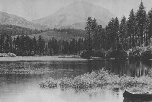
Manzanita Lake, showing Mount Lassen. Grant photo.
REFERENCES
COLBURN, F. E. W. The Kingship of Mount Lassen. 69 pp. 1922. Nemo Publishing Co., San Francisco.
COLLINS, G. L., and LIND, H. C. Lassen Glimpses. 32 pp. 1929.1
DAY, A. L., and ALLEN, E. T. The Volcanic Activity and Hot Springs of Lassen Peak. 1925. Carnegie Institute of Washington Publication No. 360.
DILLER, J. S. A Late Eruption in Northern California and Its Peculiar Lava. 33 pp. 1891. United States Geological Survey Bulletin No. 79.
FAIRFIELD, A. M. Fairfield's Pioneer History of Lassen County, California. 1916. H. S. Crocker & Co., San Francisco.
FINCH, R. H., and ANDERSON, C. A. The Quartz Basalt Eruptions of Cinder Cone, Lassen Volcanic National Park, Calif. Bull., Department of Geological Sciences, University of California Publications. Vol. 19, 1930.
GRINNEL, DIXON, LINSDALE. Vertebrate Natural History of a Section of Northern California through the Lassen Peak Region. 594 pp. University of California Publications in Zoology. Vol. 35, 1930.
HOLMES, A. G. When Will Lassen Peak Again Erupt? The Scientific Monthly, January 1935. Vol. XL, pp. 21-32.
KELLY, EDGEMOND and CHICK. Three Scout Naturalists in the National Parks. Lassen Volcanic National Park, pp. 194-209. 1931. Brewer, Warren & Putnam, New York.
LOOMIS, B. F. Pictorial History of the Lassen Volcano. 141 pp. 1926. California Press, San Francisco.1
RUSSELL, I. C. Volcanoes of North America. 346 pp. 1897.
WILLIAMS, H. Geology of the Lassen Volcanic National Park. Bulletin of the Department of Geological Sciences, University of California Publication, Vol. 21, No. 8, pp. 195-385, 1932.
______. A Recent Volcanic Eruption near Lassen Peak, California. Bulletin of the Department of Geologic Sciences, University of California Publications. Vol. 17, pp. 241-267, 1928.
______. The Dacites of Lassen Peak and Vicinity. American Journal of Science. Vol. 18, October 1929.
______. The Volcanic Domes of Lassen Peak and Vicinity. American Journal of Science. Vol. 18, October 1929.
1On sale in the park.
|
Glimpses of Our National Parks. Contains brief descriptions of the principal national parks. Address Director, National Park Service, Washington, D. C. Free. Recreational map. Shows principal recreational areas in the United States with brief descriptions of principal ones. Address as above. Free. National Parks Portfolio. By Robert Sterling Yard. More than 300 illustrations; cloth-bound. Superintendent of Documents, Washington, D. C. $1.50. Fauna of the National Parks. Series No. 1. By G. M. Wright, J. S. Dixon, and B. H. Thompson. A survey of wildlife conditions in the national parks. Illustrated. 157 pages. Superintendent of Documents, Washington, D. C. Price, 20 cents. Fauna of the National Parks. Series No. 2. By G. M. Wright and B. H. Thompson. Wildlife management in the national parks. Illustrated. 142 pages. Superintendent of Documents, Washington, D. C. Price, 20 cents. Topographic map of Lassen Volcanic National Park; 24 by 20 inches. Address Director of the United States Geological Survey, Washington, D. C. Price, 10 cents. Illustrated booklets about the following national parks may be obtained free of charge by writing to the Director, National Park Service, Washington, D. C.:
|
| <<< Previous | <<< Contents>>> |
1936/lavo/sec3.htm
Last Updated: 20-Jun-2010