|
MOUNT RAINIER
Circular of General Information 1936 |

|
ACCOMMODATIONS AND EXPENSES
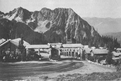
Accommodations of every type are available in Mount Rainier National Park throughout the summer season, and on a modified schedule in winter. Service at Longmire, Paradise Valley, and Yakima Park is furnished by the Rainier National Park Co., of Tacoma, Wash., and at Ohanapecosh Hot Springs by the Bridge Clinic, of Tacoma, Wash.
SUMMER SEASON
At Longmire the National Park Inn offers rooms at a cost to one person of $2.50 a day, without bath, and $3.50 with bath. A room in the cottage annex costs $2 for one person. A 10 percent discount on rooms is allowed for a 3-day stay, and 15 percent for 1 week or longer. Meals are available at the cafeteria in National Park Inn. Three-room housekeeping cabins for from 1 to 4 persons, without linen or maid service, may be rented for $3 a day and $19 a week; additional persons, 75 cents each. With linen and maid service, the rates are $5 a day and $30.50 a week; additional persons, $1 each per day.
Housekeeping cabins at Paradise Valley. Rainier National Park Co. photo.
At Paradise Valley all types of facilities, from cabins to modern hotel accommodations are available. At Paradise Inn an attractive structure of weathered cedar logs with great stone fireplaces, American-plan rates range from $6 each for 2 or more persons in a room without bath, to $8 for 1 person in room, with bath. Table d'hote meals: Breakfast, $1; luncheon, $1.25; dinner, $1.50.
Paradise Lodge near the inn cares for visitors desiring more moderately priced accommodations, and there is cafeteria meal service. Rooms for one person, $3 without bath; $4 with bath. A 10 percent discount on rooms is allowed for a 3-day stay, and 15 percent for a week or more. Housekeeping cabins of both the 3-room and 1-room type are available. The former cost the same as at Longmire, and rates for the 1-room units, without bed linen or maid service, are $1.50 a day; $4 for 3 days; and $9.50 a week for not more than 2 persons. With linen and maid service, the rates are $2.50 a day; $6.75 for 3 days; and $15.25 a week; additional persons, $1 each per day. One-room units, with bed linen but without maid service, are proportionately lower.
At Yakima Park there are 215 housekeeping cabins available at the same rates as those charged at Longmire and Paradise Valley. Cafeteria service is available, and campers' supplies may be purchased locally.
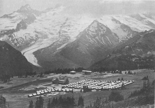
Sunrise Lodge and housekeeping cabins, Yakima Park. Grant photograph.
WINTER SEASON
A wide range of services and accommodations is available throughout the winter season in Paradise Valley, the center of skiing and other winter sports activities.
Paradise Inn offers on week days and holidays complete first-class service similar to that available during the summer season. Week-end and holiday service is American plan at $6 each per day double and $7 per day single, for a room with bath, and $5 each double and $6 single per day for a room without bath. Mid-week service is European plan, with meals a la carte at the Paradise Inn dining room and rooms from $2.25 each per day for two or more in a room without bath to a single room with bath at $4 per day. Table d'hote single meals, week-ends and holidays, are $1 each.
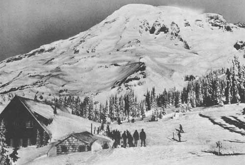
Winter sports enthusiasts view Mount Rainier. Rainier National Park Co. photo.
At Paradise Lodge rooms with or without bath are on the European plan, ranging from $2.25 each per day for two or more persons in a room without bath to $4 per day for a single room with bath. Cafeteria service is available at the Lodge dining room on week-ends and holidays only. Mid-week meal service for Lodge guests is available at the Paradise Inn dining room.
One of the most popular methods of securing accommodations in Paradise Valley during the period from December 14 to May 1 is by lease. A one-room cabin with a capacity of two people may be leased for this period for $40 and a three-room cabin with a capacity of four people may be leased for $80. Rooms in Paradise Lodge may be leased at rates ranging from four people in a room without bath for $90 to a room with bath at $150 for four people. Rooms in Paradise Inn may also be leased for this period at reasonable rates.
Rooms are offered at Longmire on the European plan at rates between $2.50 per day, single, room without bath, to $3.50 per day for a single room with bath, with additional charges of $1 per day for each additional person for rooms without bath and $1.50 per day for each additional person in rooms with bath. Rooms in cottages are $2 per day single with $1 a day for each additional person. Housekeeping accommodations are also available at Longmire. Meal service is cafeteria style. Dormitory accommodations also may be procured. Skis, snowshoes, and other necessary equipment are available at reasonable rates.
Detailed rates for winter accommodations and services are contained in a folder on winter sports in Mount Rainier National Park. This folder may be obtained also from the Seattle or Tacoma offices of the Rainier National Park Co.
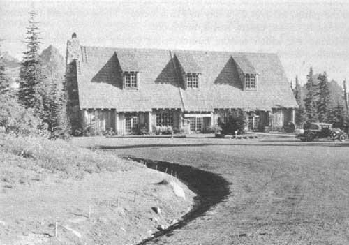
Community house at Paradise Valley. Grant photo.
OHANAPECOSH HOT SPRINGS
Lodges, cabins, and other facilities are provided at Ohanapecosh Hot Springs by the Bridge Clinic, 744 Market Street, Tacoma, Wash. (Summer address, Ohanapecosh Lodge, Packwood, Wash.)
Accommodations may be obtained at Ohanapecosh Lodge, an inviting log structure, at $4 a day per person, including meals, and $17.50 a week. Breakfast and luncheon are 75 cents each and dinner $1. Housekeeping cabins and tents may be rented at prices varying, according to the number in the party, from $1.25 a day to $15 a week. These units are furnished with beds, tables, chairs, stoves, and wood.
During the winter season, housekeeping cabins are operated at prices prevailing during the summer, but food supplies are not available.
Mineral Baths.—Modern bathing facilities are available all year under supervision of a trained attendant for those desiring to use the hot waters.
HORSEBACK TRIPS AND GUIDE SERVICE
The Rainier National Park Co. maintains saddle- and pack-horse service suited to park-trail conditions. Saddle horses and equipment cost $5 for from 5 to 8 hours' service. Pack horses on the same basis are $5. A saddle horse, with guide service, is $7.50. Several short trips are scheduled at $3, and arrangements may be made with the company for any type of trip desired, including the Wonderland Trail trip, encircling Mount Rainier, a distance of approximately 100 miles. The cost of this splendid trip ranges from $16 a day for 1 person to $10 a day each for 7 or more persons. This takes care of all expenses including pack and guide service.
Competent guides may be engaged for special trips through the park, including mountain climbs. From Paradise Valley, (where there is a guide and auditorium building in which illustrated talks about the parks are given), guide service for the summit climb ranges in cost from $25 for 1 person to $10 each for a party of 4 or more.
TRANSPORTATION
TO THE PARK
The Rainier National Park Co. operates auto-stages from Seattle and Tacoma, via Nisqually entrance, to Longmire throughout the year. Stages are operated from Tacoma and Seattle through Longmire to Paradise Valley depending upon snow conditions in the spring, throughout the summer, and until the road is closed by snow at Narada Falls in the winter.
Contingent upon snow conditions in the spring and ending on Labor Day stages are operated into Yakima Park, via White River entrance, from Tacoma, Seattle, and Yakima. After Labor Day and until Yakima Park is closed by snow, touring cars with driver may be rented by private parties for transportation into Yakima Park from Seattle and Tacoma. No transportation service is available from the city of Yakima after Labor Day.
From June 15 to September 15 transportation from Tacoma to Longmire one-way is $1.90; from September 16 to June 14 one-way from Tacoma to Longmire costs $3.40. Rates between other points are proportionate. All-year service from Ashford to Nisqually entrance, Longmire, and Narada Falls is available. From Ashford to Paradise Valley transportation service is maintained, except during the winter when the road is closed at Narada Falls.
WITHIN THE PARK
"Between station" service is made in either direction on regularly scheduled rates. Touring cars for parties of six, or busses for more, may be obtained for private parties at the regular rates for bus service, plus a car charge of $2.50 an hour. Touring cars may be rented for short trips in the vicinity of the hotels and lodges at $6 an hour.
GASOLINE SERVICE
A gasoline service station is operated at Longmire throughout the year. At Yakima Park a service station is open during the summer season. Emergency gasoline is obtainable at Paradise Valley. Motor supplies may be purchased at Longmire and Yakima Park.
TABLES OF DISTANCES
NISQUALLY ROAD, PARK ENTRANCE TO PARADISE VALLEY—20 MILES
| Name | Distance from— |
Elevation above sea level |
Remarks | |
| Park entrance |
Paradise Valley | |||
| Miles | Miles | Feet | ||
| West Side Highway junction | 1.0 | 19.0 | 2,100 | West Side junction. |
| Tahoma Creek | 1.2 | 18.8 | 2,120 | 60-foot cedar-log bridge. Beginning of West Side Trail. |
| Fallen Rock | 2.0 | 18.0 | 2,270 | Large rock which has fallen from Tumtum. |
| Columbus Tree | 3.4 | 16.6 | 2,363 | Large Douglas fir over 700 years old. |
| Kautz Creek | 3.6 | 16.4 | 2,378 | Glacial stream from Kautz Glacier. Trail to Indian Henrys Hunting Ground, 5.5 miles. |
| Bear Prairie Point | 4.8 | 15.2 | 2,500 | Magnificent view of mountain. |
| Longmire | 6.6 | 13.4 | 2,750 | Superintendent's headquarters. |
| Indian Henry Trail | 7.0 | 13.0 | 2,850 | Trail to Indian Henrys Hunting Ground, 6.5 miles. |
| Cougar Rock | 8.0 | 12.0 | 3,000 | High Rock, base of Rampart Ridge. |
| Christine Falls | 10.9 | 9.1 | 3,667 | Beautiful falls. Trail to Comet Falls and Van Trump Park, 3 miles. |
| Nisqually Glacier | 11.9 | 8.1 | 3,908 | Comfort station; trail to end of glacier. |
| Ricksecker Point | 13.4 | 6.6 | 4,212 | Fine view of mountain and surrounding country. |
| Silver Forest | 15.0 | 5.0 | ----- | Fire killed, weathered gray tree trunks. |
| Narada Falls | 16.0 | 4.0 | 4,572 | Falls in Paradise River; 168-foot drop. |
| Inspiration Point | 17.3 | 2.7 | 4,900 | Magnificent view. |
| Paradise Valley | 20.0 | 0.0 | 5,400 | District ranger; Paradise Inn. |
| Public camp grounds | 20.4 | 0.4 | 5,400 | Free camp sites, community building, and cabins. |
WEST SIDE HIGHWAY, NISQUALLY ROAD TO NORTH PUYALLUP RIVER—15.1 MILES
| Name | Distance from— |
Elevation above sea level |
Remarks | |
| Nisqually Road |
North Puyallup River | |||
| Miles | Miles | Feet | ||
| Fish Creek | 3.9 | 11.2 | 2,923 | Small clear stream. Good fishing. |
| Tahoma Camp | 4.2 | 10.9 | 3,146 | Wonderland Trail branches to Indian Henry. |
| Tahoma Vista | 5.4 | 9.7 | 3,458 | Fine view of mountain and surrounding country. |
| Round Pass | 6.9 | 8.2 | 3,879 | Trail branches to Lake George, 1.2 miles. |
| South Puyallup River | 8.3 | 6.8 | 3,479 | River crossing. |
| St. Andrews Creek | 11.2 | 3.9 | 3,743 | Trail to Klapatche Park, 3 miles. |
| Klapatche Point | 12.4 | 2.7 | 4,117 | Fine viewpoint. |
| North Puyallup River | 15.1 | 0.0 | 3,707 | Parking area. View of Hanging Glacier. Trail to Klapatche Park, 3 miles. |
WHITE RIVER ROAD, JUNCTION WITH STATE HIGHWAY TO YAKIMA PARK—15.6 MILES
| Name | Distance from— |
Elevation above sea level |
Remarks | |
| State road |
Yakima Park | |||
| Miles | Miles | Feet | ||
| Entrance checking station | 1.4 | 14.2 | 3,470 | Purchase automobile permit. |
| East Side Trail | 3.8 | 11.8 | 3,745 | Trail to Owyhigh Lakes and Ohanapecosh. |
| Fryingpan Creek Bridge | 4.4 | 11.2 | 3,840 | Wonderland Trail to Summerland Indian Bar, etc. |
| White River Bridge | 5.4 | 10.2 | 3,965 | Road to Old White River Camp Ground. Trail to Snout of Emmons Glacier, Glacier Basin, Yakima Park, etc. |
| Yakima Creek | 8.2 | 7.4 | 4,830 | Water for radiators. |
| Sunrise Point | 12.9 | 2.7 | 5,085 | Wonderful panorama of surrounding peaks, including entire Cascade Range, Mount Baker, Glacier Peak, Mount Adams, Mount Stuart, and Mount Hood. |
| Yakima Park | 15.6 | 0.0 | 6,385 | Ranger headquarters; housekeeping cabins; cafeteria; small camping area. |
| Camp grounds and picnic area | 16.9 | 1.3 | 6,200 | Large public camp ground; picnic area; Shadow Lake. |
CARBON RIVER ROAD, PARK ENTRANCE TO SIX MILE CREEK—6 MILES
| Name | Distance from— |
Elevation above sea level |
Remarks | |
| Park entrance |
Six Mile Creek | |||
| Miles | Miles | Feet | ||
| Carbon River entrance | 0.0 | 6.0 | 1,800 | Ranger checking station. |
| Ipsut Creek | 5.0 | 1.0 | 2,500 | Ipsut Creek-Mowich Lake Trail junction. |
| Six Mile Creek | 6.0 | 0.0 | 2,650 | End of road; camp ground. Trail leaves camp ground for Lake James, Yakima Park, Wonderland Trail, and shelter cabin. |
PARADISE TRAIL FROM LONGMIRE SPRINGS TO PARADISE VALLEY—5.9 MILES
| Name | Distance from— |
Elevation above sea level |
Remarks | |
| Longmire Springs |
Paradise Valley | |||
| Miles | Miles | Feet | ||
| Longmire Springs | 0.0 | 5.9 | 2,760 | Superintendent's headquarters, hotel, cabins, camp grounds. |
| Mouth of Paradise River | 1.6 | 4.3 | 3,150 | Bridge over Nisqually River. |
| Carter Falls | 2.7 | 3.2 | 3,500 | On Paradise River. |
| Madcap Falls | 2.9 | 3.0 | 3,600 | Do. |
| Narada Falls | 4.4 | 1.5 | 4,572 | Principal falls on Paradise River with sheer drop of 168 feet. |
| Paradise Inn, lodge, camp | 5.9 | 0.0 | 5,400 | Hotel, lodge, cabins, camp. |
WONDERLAND TRAIL, PARADISE VALLEY TO YAKIMA PARK—29 MILES
PARADISE VALLEY TO NICKEL CREEK—9 MILES
| Name | Distance from— |
Elevation above sea level |
Remarks | |
| Paradise Valley |
Yakima Park | |||
| Miles | Miles | Feet | ||
| Paradise Valley | 0.0 | 29.0 | 5,400 | Ranger station, hotel, lodge, housekeeping cabins, camp grounds, etc. |
| Reflection Lakes | 2.0 | 27.0 | 4,860 | Beautiful clear lakes. |
| Louise Lake | 3.0 | 26.0 | 4,590 | Beautiful clear lake. |
| Stevens Canyon | 4.0 | 25.0 | ----- | |
| Martha Falls | 4.5 | 24.5 | 3,110 | Beautiful falls in Martha Creek. |
| Stevens Creek Crossing. | 7.0 | 22.0 | 2,730 | |
| Muddy Fork Box Canyon | 8.0 | 21.0 | 3,040 | One of the most beautiful river canyons in America, across which a horse and foot bridge has been built 100 feet above the water. |
| Nickel Creek | 9.0 | 20.0 | 3,300 | Patrol and shelter cabins. |
NICKEL CREEK TO INDIAN BAR—6.5 MILES | ||||
| Nickel Creek | 9.0 | 20.0 | 3,300 | Patrol and shelter cabins. |
| Cowlitz Divide | 10.5 | 18.5 | 4,770 | Trail branches to Ohanapecosh Hot Springs development, 2.5 miles. |
| Indian Bar | 15.5 | 13.5 | 4,150 | Beautiful basin above Wauhaukaupauken Falls. Shelter cabin. |
INDIAN BAR TO SUMMERLAND—4 MILES | ||||
| Indian Bar | 15.5 | 13.5 | 4,150 | Shelter cabin. |
| Ohanapecosh Park | 16.5 | 12.5 | 5,500 | Beautiful region; many waterfalls and rugged peaks. |
| Fryingpan Glacier | 18.0 | 11.0 | 6,750 | Trail crosses over ice. |
| Summerland | 19.5 | 9.5 | 5,900 | Beautiful park; many flowers amid rugged surroundings. |
SUMMERLAND TO YAKIMA PARK—9.5 MILES | ||||
| Summerland | 19.5 | 9.5 | 5,900 | Beautiful park. |
| White River Road at Fryingpan Creek | 23.8 | 5.2 | 3,840 | Fryingpan Creek Highway Bridge. |
| White River Road at White River Bridge | 24.8 | 4.2 | 3,965 | Highway bridge over White River. |
| Old White River Camp | 26.1 | 2.9 | 4,600 | Trail to Snout of Emmons Glacier, Glacier Basin, and Burroughs Mountain. |
| Yakima Park | 29.0 | 0.0 | 6,400 | Ranger headquarters, cabins, etc. |
EAST SIDE TRAIL, OHANAPECOSH HOT SPRINGS TO WHITE RIVER ROAD—17 MILES
| Name | Distance from— |
Elevation above sea level |
Remarks | |
| Ohanapecosh Hot Springs |
White River Road | |||
| Miles | Miles | Feet | ||
| Ohanapecosh Hot Springs | 0.0 | 17.0 | 2,000 | Ranger cabin, telephone, lodge, tents, cabins, bathhouse, camp grounds. |
| Laughing Water Creek | 0.6 | 16.4 | 2,000 | Clear stream. |
| Silver Falls | 1.0 | 16.0 | 2,050 | On Ohanapecosh River. |
| Cedar Flat | 2.0 | 15.0 | 2,300 | Many large cedars. |
| Couger Creek | 3.8 | 13.2 | 2,325 | Clear stream in heavy timber. |
| Olallie Creek Cut-off Trail | 4.0 | 13.0 | 2,350 | Short cut to Olallie Creek. |
| Whittier Creek | 5.4 | 11.6 | 2,700 | Clear stream. |
| Stafford Falls | 6.5 | 10.5 | 2,775 | On Ohanapecosh River. |
| Fork of Chinook Creek | 7.8 | 9.2 | 3,124 | Heavily timbered basin. |
| Boundary Creek | 8.5 | 8.5 | 3,275 | Patrol cabin. |
| Sydney Falls | 9.1 | 7.9 | 3,600 | Beautiful falls on Kotsuck Creek; shelter cabin; telephone. |
| Horseshoe Fails | 11.5 | 5.5 | 5,000 | Beautiful falls on Kotsuck Creek. |
| Goats Pass | 12.2 | 4.8 | 5,300 | |
| Owyhigh Lakes | 12.6 | 4.4 | 5,150 | Beautiful lakes amid rugged peaks. |
| White River Road | 17.0 | 0.0 | 3,700 | |
WONDERLAND TRAIL, YAKIMA PARK TO CARBON RIVER ROAD—15 MILES
| Name | Distance from— |
Elevation above sea level |
Remarks | |
| End of Carbon River Road |
Yakima Park | |||
| Miles | Miles | Feet | ||
| Yakima Park | 15.0 | 0.0 | 6,400 | Beautiful park; unobstructed view of mountain camp, cabins, lodge. |
| Trail Junction | 12.9 | 2.1 | 6,550 | Junction of Mystic Lake Trail. |
| Winthrop Glacier | 9.2 | 5.8 | 4,800 | Second largest glacier in park. |
| Mystic Lake | 7.0 | 8.0 | 5,750 | Clear, beautiful lake; shelter cabins; magnificent views obtained. |
| Moraine Park | 5.1 | 9.9 | 5,700 | Good camping; grass and water. |
| Moraine Cabin | 5.0 | 10.0 | 5,100 | Shelter cabin. |
| Carbon Glacier | 3.5 | 11.5 | 3,355 | Lowest perpetual ice field in the United States. |
| End of Carbon River Road | 0.0 | 15.0 | 3,175 | Shelter cabin; Wonderland Trail junction with Carbon River Road. |
WONDERLAND TRAIL, CARBON RIVER TO LONGMIRE—46.5 MILES
END OF CARBON ROAD TO MOWICH LAKE—12 MILES
| Name | Distance from— |
Elevation above sea level |
Remarks | |
| End of Carbon River Road |
Longmire | |||
| Miles | Miles | Feet | ||
| End of Carbon River Road. | 0.0 | 46.5 | 3,175 | Shelter cabin Wonderland Trail; junction with Carbon River Road. |
| Mist Park | 6.0 | 40.5 | 5,500 | Beautiful park at head of Cataract Creek. |
| Spray Park | 8.0 | 38.5 | 6,000 | Most beautiful park on north side. |
| Spray Falls | 8.3 | 38.2 | 5,500 | Highest and most beautiful fall on north side. |
| Eagle Cliffs | 9.0 | 37.5 | 5,300 | Fine view of Mount Rainier. |
| Mowich Lake | 12.0 | 34.5 | 4,930 | Beautiful clear lake; fishing; good camping; shelter cabin; telephone; branch trails to Carbon River Road. Via Ipsut Pass, 8 miles, and to West Boundary, via Mountain Meadows, 4.5 miles. |
MOWICH LAKE TO SUNSET PARK—10.5 MILES | ||||
| Mowich Lake | 12.0 | 34.5 | 4,930 | Beautiful clear lake; fishing; good camping; shelter cabin; telephone; branch trails to Carbon River Road. Via Ipsut Pass, 8 miles, and to West Boundary, via Mountain Meadows, 4.5 miles. |
| North Mowich River | 15.5 | 31.0 | 2,650 | |
| South Mowich River | 16.0 | 30.5 | 2,650 | Good fishing. |
| Golden Lakes | 20.8 | 25.7 | 5,000 | Numerous beautiful clear lakes; good fishing and camping. |
SUNSET PARK TO LONGMIRE VIA INDIAN HENRYS—24 MILES | ||||
| Sunset Park | 22.5 | 24.0 | 5,500 | Beautiful upland park; telephone; patrol and shelter cabins. |
| North Puyallup River (end of West Side Road) | 26.7 | 19.8 | 3,500 | Highway bridge; view of overhanging glacier. |
| Klapatche Park | 29.2 | 17.3 | 5,500 | Beautiful alpine park; shelter cabin. |
| St. Andrews Park | 30.2 | 16.3 | 5,700 | Beautiful alpine park. |
| South Puyallup River | 33.5 | 13.0 | 3,800 | View of South Puyallup River. |
| Tahoma Creek Crossing | 37.0 | 9.5 | 4,200 | Trail bridge over Tahoma Creek. |
| Indian Henrys | 39.0 | 7.5 | 5,300 | Patrol cabin; shelter cabin; telephone; all points of interest are in close proximity to station. |
| Squaw Lake | 40.0 | 6.5 | 5,000 | Small clear lake. |
| Kautz Creek | 43.7 | 2.8 | 3,700 | Fast-flowing stream from Kautz Glacier. |
| Ramparts Ridge | 44.5 | 2.0 | 3,800 | Trail over Ramparts Ridge to Longmire. |
| Van Trump Trail | 44.8 | 1.7 | 3,500 | Trail branches to Van Trump Park. |
| Longmire | 46.5 | 0.0 | 2,760 | Superintendent's headquarters; hotels; cabins; camp grounds; interesting side trips. |
PRINCIPAL POINTS OF INTEREST
REACHED FROM PARADISE VALLEY
[Best reached on foot]
| Name | Distance and direction from Paradise Valley |
Elevation above sea level |
Remarks |
| Miles | Feet | ||
| Nisqually Glacier | 1.25 W | 5,500 | Largest glacier on south side of Mount Rainier. |
| Glacier Vista | 1.2 N | 6,300 | Wonderful view of entire Nisqually Glacier and mountain. |
| Panorama Point | 1.8 N | 6,800 | Panorama of Paradise Valley and Nisqually watershed. |
| Alta Vista | 0.6 N | 5,800 | Fine view; marker to identify all peaks and prominent points. |
| Monument | 1.5 NE | 5,900 | Where Chief Sluiskin, Indian guide, waited return of first summit climbers. |
| Golden Gate | 1.5 NE | 6,500 | Where Paradise Glacier and Skyline trails cross. |
| Reflection Lakes | 2 SE | 4,861 | Beautiful clear lakes on bench north of Pinnacle Peak, Tatoosh Range. |
| Bench Lake | 2.5 SE | 4,500 | On lower bench overlooking Stevens Canyon. |
| Pinnacle Peak | 3 SE | 6,562 | Sharp peak on Tatoosh Range. Easy trip from Paradise Park. |
| Stevens Peak | 4 SE | 6,511 | At east end of Tatoosh Range. |
| Unicorn Peak | 4.75 SE | 6,939 | Highest peak on Tatoosh Range. Pinnacle, Stevens, and Unicorn Peaks are easy to climb, and a fine view of the surrounding country may be had from all of them. |
| Sluiskin Falls | 1.25 NE | 5,900 | First fall of Paradise River below Paradise Glacier 300 feet high. |
| Paradise Glacier | 1.5 NE | 6,500 | Clear ice glacier. Source of Paradise River on east side of Paradise Park. |
| Stevens Glacier | 1.75 NE | 6,000 | East lobe of Paradise Glacier draining into Stevens Canyon. |
| Stevens Ice Cascades | 2 NE | ----- | Crevassed slope of Stevens Glacier. |
| Stevens Water Cascades | 2.25 NE | ----- | At foot of Stevens Glacier. |
| Stevens Canyon | 2.25 NE | ----- | Below Stevens Glacier. 4 miles long, 1/2 mile wide, 1,000 to 2,000 feet deep. |
| Fairy Falls | 2.75 NE | 5,500 | Beautiful falls 700 feet high at head of Stevens Canyon. |
| Mazama Ridge | 1.5 SE | 5,900 | Noted for abundance of beautiful wild flowers. |
| Faraway Rock | 2.8 SE | 5,300 | Excellent panorama of Tatoosh Range with lakes in foreground. |
| Lake Louise | 2.5 SE | 4,500 | Beautiful lake. Good fishing. |
| Cowlitz Glacier | 3 NE | 4,500 | Largest glacier on southeast side of the mountain. |
| Cowlitz Rocks | 2.5 NE | 7,457 | Ridge dividing Paradise Glacier from Cowlitz Glacier. |
| Granite Falls | 3.5 NE | ----- | Large volume of water with sheer drop of 350 feet. |
| Cathedral Rocks | 3.25 N | 8,262 | Lofty spires between Cowlitz and Ingraham Glaciers. |
| Cowlitz Chimneys | 8 NE | 7,607 | Large chimney-like peaks on divide between Cowlitz River and White River. |
| McClure Rock | 2 N | 7,384 | Flat rocky platform overlooking Paradise Glacier. |
| Anvil Rock Fire Lookout Station | 3.25 N | 9,584 | Sharp crest halfway between McClure Rock and Camp Muir. The trail leads over snow fields. |
| Camp Muir shelter hut | 3.75 N | 10,000 | Saddle at foot of Cowlitz Cleaver, up which the trail to the summit of the mountain leads. To this point the ascent is easy. Mostly over snow fields. |
| Beehive | 4.25 N | 11,033 | Pinnacle on Cowlitz Cleaver. Its shape resembles a beehive. |
| Camp Misery | 4.25 N | 11,033 | Above the Beehive. |
| Gibraltar Rock | 4.75 N | 12,679 | Large rock mass at head of Cowlitz Glacier, along west ledge of which the ascent is made, often with the aid of ropes. This rock divides the feeders of 3 glaciers—Nisqually on the south, Cowlitz on the east, and Ingraham on the north. |
| Register Rock | 6.5 N | 14,161 | First point reached on rim of east crater. |
| Columbia Crest | 7 N | 14,408 | Huge snowdrift on northwest side of east crater. Highest summit of Mount Rainier. |
| Point Success | 7.25 N | 14,150 | Most southern summit. About 250 feet lower than Columbia Crest. |
| Liberty Cap | 7.5 N | 14,112 | High summit near the north end of mountain. |
| East Crater | 6.5 N | 14,100 | Main crater on east side of Columbia Crest about 1,400 feet in diameter. |
REACHED FROM YAKIMA PARK
| Name | Distance and direction from ranger headquarters |
Elevation above sea level |
Remarks |
| Miles | Feet | ||
| Sourdough Trail | 2.5 N. | 6,500 | Easily accessible trail to Frozen Lake and Dege Peak. Wonderful view of Mount Rainier. |
| Burroughs Mountain | 2.5 W. | 7,000 | Wonderful view of Mount Rainier and surrounding ranges. |
| Frozen Lake | 1.3 NW. | 6,700 | Water-supply reservoir. Barren region. |
| Glacier Basin | 5.8 SW. | 5,939 | Old mine, view of mountain. |
| Berkeley Park | 2.8 W. | 6,000 | Beautiful alpine park, wild flowers. |
| Dege Peak | 1.8 NE. | 7,006 | On Sourdough Trail. An easy climb to good view of other Cascade peaks. |
| Clover Lake | 3 NE | 5,728 | Good fishing, wild flowers. |
| Shadow Lake | 1 SW | 5,800 | Small lake near picnic ground. No fishing permitted. |
| Old White River public camp | 3 S | 4,500 | Quiet protected camp grounds near terminus of Emmons Glacier. |
| Grand Park | 5.5 NW. | 5,700 | Largest mountain park on north side. Excellent views. |
| Summerland Park | 9.5 S. | 5,900 | Beautiful alpine park amid rugged peaks. |
| Emmons Glacier | 4.2 SW. | 4,719 | Largest glacier in continental United States. |
| Lake James | 12 NW. | 4,370 | Beautiful lake set in dense forest. A 2-day trip. |
| Owyhigh Lakes | 9.8 SE | 5,200 | Alpine lakes and flower fields on East Side Trail. |
| Natural Bridge | 15 NW | 5,500 | One of the natural wonders of the park. |
| Winthrop Glacier | 5 W | 5,100 | Second largest glacier on mountain. On trail to Mystic Lake. |
| St. Elmo Pass | 6 SW | 7,415 | High pass above timberline overlooking both Emmons and Winthrop Glaciers. |
| Mystic Lake | 8 W | 5,700 | Alpine lake and flower fields. |
| Steamboat Prow | 8 SW. | 9,500 | Upper end of cleaver dividing Winthrop and Emmons Glaciers. |
| Camp Curtis | 6.5 SW | 9,000 | Protecting rock used as shelter for overnight camp by hikers to summit. |
| Columbia Crest | 10 SW | 14,408 | Huge snowdrift on northwest side of east crater. Highest point on Mount Rainier. |
| Mount Freemont | 2.5 NW | 7,200 | Fire Lookout. |
REACHED FROM LONGMIRE
| Name | Distance and direction from Longmire |
Elevation above sea level |
Remarks |
| Miles | Feet | ||
| Eagle Peak | 3.5 E. | 5,955 | West end of Tatoosh Range. Magnificent view of mountain and surrounding country. |
| River Trail | 1.2 NE | 3,100 | Easy trail through fine timber. Cross Nisqually River on log and return via opposite side of river for round trip. |
| Public camp grounds | 0.5 E | 2,700 | Free auto camp, community house, where nature lectures are given by a naturalist. |
| Beaver dams | 2.3 S. | 2,500 | Interesting beaver workings. |
| Lake George | 1.5 NW1 | 4,232 | Beautiful lake. Good fishing. |
| Mount Wow | 1.5 W1 | 6,030 | Good hard climb. Mountain goats often seen. |
| Glacier Bridge | 3.8 NE | 3,908 | One-half mile from snout of Nisqually Glacier. |
| Narada Falls | 4.4 NE | 4,572 | Principal falls on Paradise River with sheer drop of 150 feet. |
| Paradise Valley | 5.9 NE | 5,557 | Camps, hotels; base for mountain climb. |
|
1Distance given is from road.
| |||
REACHED FROM OHANAPECOSH
| Name | Distance and direction from Ohanapecosh |
Elevation above sea level |
Remarks |
| Miles | Feet | ||
| Silver Falls Loop | 1.2 N | 2,000 | Beautiful falls on Ohanapecosh River. Follow new trail on north side of river and return via old trail on south side. Good fishing. |
| Twin Lakes | 6.5 NE | 5,000 | Two picturesque lakes on Cascade Crest Trail, reached through heavy timber. |
| Tipsoo Lake | 18 N | 5,400 | Via Cascade Crest Trail, 18 miles, or via Cayuse Pass and East Side Trail, 12 miles. |
| Cowlitz Divide | 4.5 NE | 4,770 | Good view at summit, which is reached by a trail through a deep forest. Junction with Wonderland Trail to Indian Bar, Ohanapecosh Park, and Panhandle Gap. |
REFERENCES
ALBRIGHT, HORACE M., and TAYLOR, FRANK J. Oh, Ranger! A book about the national parks.
JEFFERS, LE ROY. The Call of the Mountains, 282 pp., illustrated. Dodd, Mead & Co. 1922. Mount Rainier Park on pp. 46-54.
KELLEY, EDGEMOND, and CHICK. Three Scout Naturalists in the National Parks. Brewer, Warren and Putnam. 1931.
MEANY, E. S. Mount Rainier, a Record of Exploration. 1916. 325 pp., illustrated.
MILLS, ENOS, A. Your National Parks. 1917. 532 pp., illustrated.
MOUNTAINEER, THE. Bulletins published by the Mountaineers (Climber's Club), of Seattle, Washington. Mount Rainier on pp. 116-136, 460-469.
ROLFE, MARY A. Our National Parks. Book Two. A supplementary reader on the national parks for fifth- and sixth-grade students. Benjamin H. Sanborn, Chicago, 1928.
RUSSELL, I. C. Glaciers of North America. 1897. 210 pp. Mount Rainier on pp. 62-67.
______. Volcanoes of North America. 1897. 346 pp. Mount Rainier on pp. 241-245.
SCHMOE, F. W. Our Greatest Mountain. A handbook for Mount Rainier National Park. 366 pp., illustrated. G. P. Putnam's Sons, New York City. 1925.
STEELE, W. G. The Mountains of Oregon. 1890. 112 pp. Mount Rainier on pp. 43-51, 55-65.
WILLIAMS, JOHN H. The Mountain That Was "God." 1911. 144 pp., 200 illustrations.
VANCOUVER, CAPT. GEORGE. Discovery of the North Pacific Ocean. 1790-95; p. 235.
WINTHROP, THEODORE. The Canoe and the Saddle, or Klalam and Klickatat. 1862. With the author's western letters and journals. Edited by John H. Williams. 16 color plates and 100 other illustrations. 1913. 332 pp. Mount Rainier on pp. 36-41, 100-122, 260, 273-274, 281-283, 309-318.
YARD, ROBERT STERLING. The Top of the Continent. 1917. 244 pp., illustrated. Mount Rainier on pp. 115-139.
______. The Book of the National Parks. 1926. 444 pp., 74 illustrations, 14 maps and diagrams. Mount Rainier on pp. 156-183.
Wild flowers in contrast to fields of ice.
|
Glimpses of Our National Parks. An illustrated booklet of 92 pages. Address Director, National Park Service, Washington, D. C. Free. Automobile Road Map of Mount Rainier National Park. Available in the park only. Free. Guide to hiking trips and trail information. Obtainable on personal application at park headquarters at Longmire. Free. Mount Rainier and Its Glaciers. By F. E. Matthes. 48 pages, illustrated. Superintendent of Documents, Washington, D. C. 15 cents. Features of the Flora of Mount Rainier National Park. By J. B. Flett. 48 pages, illustrated. Superintendent of Documents, Washington, D. C. 25 cents. Forests of Mount Rainier National Park. By G. F. Allen. 32 pages, illustrated. Superintendent of Documents, Washington, D. C. 20 cents. Mammals and Birds of Mount Rainier National Park. By W. P. Taylor and W. T. Shaw. 241 pages, illustrated. Superintendent of Documents. Washington, D. C. 85 cents. Fauna of the National Parks. Series No. 1. G. M. Wright, J. S. Dixon, and B. H. Thompson. Survey of wildlife conditions in the national parks. 157 pages, illustrated. Superintendent of Documents, Washington, D. C. 20 cents. Fauna of the National Parks. Series No. 2. By G. M. Wright and B. H. Thompson. Wildlife management in the national parks. 142 pages, illustrated. Superintendent of Documents, Washington, D. C. 20 cents. National Parks Portfolio. By Robert Sterling Yard. Cloth bound; illustrated with more than 300 carefully chosen photographs. Superintendent of Documents, Washington, D. C. $1.50. Topographic Map of Mount Rainier National Park. In color. 20 by 18-3/4 inches. United States Geological Survey, Washington, D. C. 10 cents. Booklets about the national parks listed below may be obtained free of charge by writing the Director, National Park Service, Washington, D. C.:
|
| <<< Previous | <<< Contents>>> |
1936/mora/sec3.htm
Last Updated: 20-Jun-2010