|
ZION
BRYCE CANYON
Circular of General Information 1936 |

|
ZION AND BRYCE CANYON
National Parkx
• ZION—OPEN ALL YEAR •
• BRYCE CANYON—MAY 10 TO NOVEMBER 1 •
FOR gorgeous coloring and unusual erosional formations the canyon country of southwestern Utah and northern Arizona has no equal. The canyons themselves are stupendous in size and formation, and of brilliant hues, glowing, almost unbelievably. It is in this country that Zion and Bryce Canyon National Parks and Cedar Breaks National Monument are located.
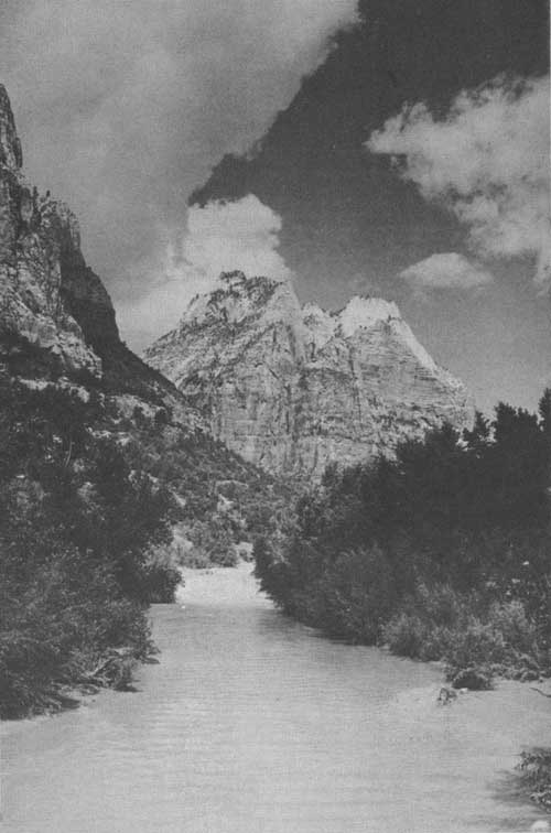
The Monastery with Virgin River in foreground. Grant photo.
ZION NATIONAL PARK
Zion National Park, Utah, created by act of Congress approved November 19, 1919, was, prior to its reservation as a park, a national monument, called by the Indian name of the river, Mukuntuweap. The first monument proclamation was issued by President Taft on July 31, 1909. On March 18, 1918, the monument was enlarged by President Wilson to include a total of 76,800 acres, and the name changed to Zion. The new name is especially appropriate, for since early days its principal accessible feature has been called Zion Canyon by the Mormon settlers, who, being deeply religious, felt that the great mountains forming the canyon walls were in truth temples of God. The act of Congress giving the reservation national-park status did not increase its area. By an act of Congress approved June 13, 1930, an additional 18,088 acres on the east and south sides were included in the park. The total area is 148.2 square miles.
A "Yosemite Valley done in oils" comes close to a description of the principal feature of Zion National Park. This gorgeous valley has about the same dimensions as the famous Yosemite Valley. Extraordinary as are the sandstone forms, the color is what most amazes. The deep red of the Vermilion Cliff is the prevailing tint. Two-thirds of the way up, these marvelous walls and temples are painted gorgeous reds; then, above the reds, they rise in startling white. Sometimes the white is surmounted by a cap of vivid red, remains of another red stratum which once overlay all. The other colors are many and brilliant. The Vermilion Cliff rests upon 350 feet of even a more insistent red relieved by mauve and purple shale. That in turn rests upon a hundred feet of other variegated strata.
Through these successive layers of sands and shales and limestones, colored like a Roman sash, glowing in the sun like a rainbow, the Virgin River has cut its amazing valley. The entrance is between two gigantic stone masses of complicated architectural proportions which are named the West Temple and The Watchman. The latter is seen from a foreground of river. From a stairway of many colors it springs abruptly 2,500 feet. Its body is a brilliant red. The West Temple, which rises directly opposite and a mile back from the rim, is more than a thousand feet higher, and is the highest point within the park.
Passing the gates, the traveler stands in a canyon of nearly perpendicular sides more than a half a mile deep, half a mile wide at the bottom, a mile wide from crest to crest, whose walls blaze with color. On the right is Bridge Mountain, so named because there is an interesting natural bridge or "flying buttress" high up on its face, visible from the checking station. It is in the face of this mountain, on the Pine Creek side, that the famous Zion Tunnel is located. Beyond Bridge Mountain rises the massive East Temple, rich in hue, followed in succession by the Twin Brothers and the Mountain-of-the-Sun. On the opposite side of the canyon are to be seen the Streaked Wall and The Sentinel. Farther up is the Court of the Patriarchs above which stand the Three Patriarchs. On the same side of the canyon, opposite Zion Lodge, are Lady Mountain and the group of Mount Majestic, Castle Dome, and Spearhead Point.
Above the Lodge, against the east wall, stands the most remarkable rock pile of the region, a collossal truncated dome known as the Great White Throne. Seen through a saddle in the low red rock wall lying in front of it, this dome appears white above and red below. In reality, however, the huge rock is gray or white in color, with faint pink washings showing in places down its sides. Directly opposite it is a lesser monolith, although itself gigantic, called Angels Landing.
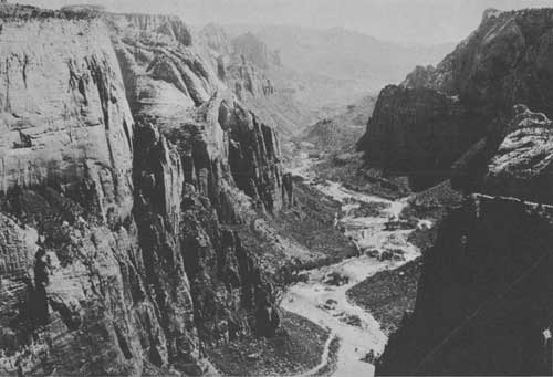
Zion Canyon. Zion Studios photo.
North of the Great White Throne the chiseling stream makes a great swing, past a projecting rock formation on the left known as the Great Organ. Farther on the mystic temple of Sinawava is entered. This is a great natural amphitheater, encircled with walls that appear to close behind as one enters. The floor is lined with deciduous trees accompanied by a remarkable assortment of other vegetation. In the center of the circle stand two large stone pillars. The larger is the altar, the smaller one the pulpit. The south side of the altar bears the profile view of a great stone face known as the Guardian of the Temple, and is chiefly remarkable for the change of expression which takes place as one enters the sacred confines which he guards. The road ends at the temple.
From the temple for a distance of a mile up the river, a fine trail has been built up to The Narrows. At the end of the trail the cliffs rise sheer from the edge of the river, and further explorations must be made on horseback with a qualified guide. No park visitor should leave the park until he has at least made this mile walk to The Narrows.
In contrast to the desert surroundings many springs trickle from various levels in the walls of the canyon, developing new tributary gorges, alcoves, and grottoes, which are decorated with trailing ferns and flowering plants. In the early spring the melting snows bring an added volume of water, which causes numerous waterfalls, while a really magnificant spectacle is produced by summer rains, when cascades tumble everywhere from the polished domes and cliffs. The waterfalls of Zion, once seen, are never forgotten.
Along the sides of the river, as it winds its way through the canyon, grow willows and poplars, and wild flowers abound. The trails leading up to the East and West Rims pass through forests of aspen, pine, and fir, and many varieties of wild flowers dot the ground.
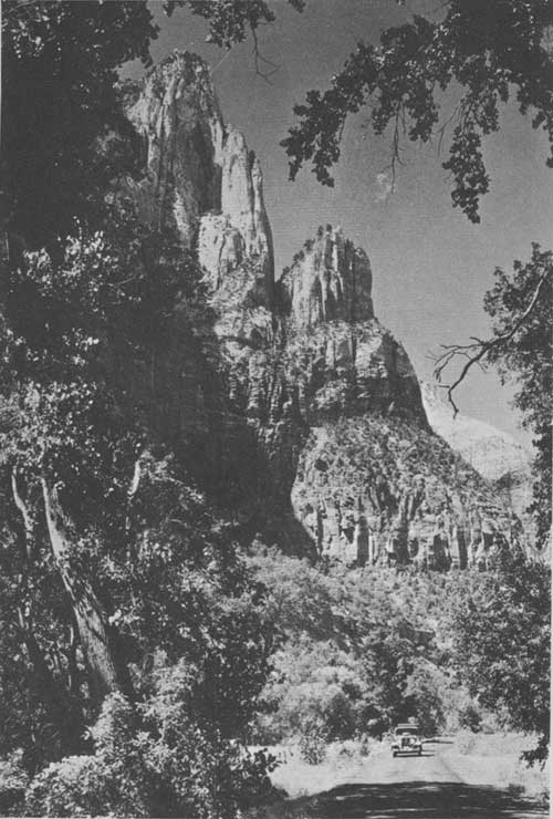
Lady Mountain from canyon floor. Grant photo.
FEATURES OF INTEREST
Cliff ruins have been discovered in Zion Park and its vicinity, proving that long before Little Zion gave sanctuary to the Mormons it was the home of a prehistoric people. The ruins are principally in Parunuweap Canyon, 8 miles from the roads, and are inaccessible to visitors, no roads or trails having been constructed to them. It is believed that these ancients farmed down near the creek while living up in the face of the cliffs at places that would be almost inaccessible to hostile tribes unfamiliar with the region. Many interesting artifacts have been found in these ruins.
As though it were not enough to have been a place of refuge in prehistoric and modern times, and now a thing of beauty that gladdens and thrills and inspires all who see it, this area is also a workshop of nature where new wonders are being formed; for here are natural bridges in the making. The most interesting of these is the Great Arch of Zion, located in Pine Creek Canyon, which is 720 feet long, 580 feet high, and is cut back into the supporting cliff a distance of 90 feet. A nearly level trail reaches the top of the Great Arch formation. The trail is one-half mile in length and begins at the east portal of Zion Tunnel.

Zion National Park—Zion Canyon area.
(click on image for a PDF version)
ROADS IN THE PARK
There is a total of 20 miles of improved roads in Zion Park. One road leads from the park entrance to the Temple of Sinawava, a distance of 8 miles. No one has really seen Zion Canyon until he has made a trip over this road, and visitors driving in closed cars should make frequent stops so that they may get out and enjoy the magnificent view. The canyon is so narrow and its walls so high that a top of any kind to a car cuts off the view almost completely.
Also within the park is a stretch of the remarkable Zion-Mount Carmel Highway, 11-1/2 miles in length. Running east from the Virgin River Bridge, this road forms a connecting link between United States Highways Nos. 91 and 89. Its total length from park headquarters to Mount Carmel Junction is 25 miles.
The Zion-Mount Carmel Highway has been called "the most spectacular feat of highway construction ever undertaken", due to the stupendous construction difficulties encountered in building it. The first of these was how to get the road up over the great cliffs forming the wall of the canyon. From its start on the floor of the valley, the road zigzags up over the talus slope in Pine Creek Canyon in a series of six switch-backs. In an area little more than a mile long and half a mile wide there have been located 3-1/2 miles of roadway. At the end of this section the road enters a tunnel 5,607 feet long, where it continues to ascend on a 5 percent grade. This tunnel follows quite closely the face of the cliff, and at six selected points galleries overlooking the canyon below have been broken out. From them a colorful panorama spreads itself with vivid reds blending with the green of the foliage in startling scenic effects.
Some of the most remarkable views of southern Utah are to be found along this road. While the tunnel is the most spectacular portion, other sections are of even greater scenic interest.
Work on this project was started in October 1927, and it was completed early in the summer of 1930. The total cost of the highway was close to $2,000,000, of which a million and a half was spent on the park section. That portion outside the park was built under Federal aid in cooperation with the State.
DISTANCE IN MILES ON MAIN ROAD FROM PARK SOUTH ENTRANCE TO POINTS OF INTEREST
| Read down | Read up | ||
| 0.0 | Zion National Park south boundary line | 8.0 | |
| .1 | Checking station | 7.9 | |
| .6 | Cafeteria and cabin area | 7.4 | |
| .6 | South Entrance Public Camp Ground | 7.5 | |
| .6 | Oak Creek | 7.4 | |
| .8 | West Temple, Altar of Sacrifice, on west side | 7.2 | |
| 1.0 | Bridge Mountain on east | 7.0 | |
| 1.3 | Park headquarters | 6.7 | |
| 1.5 | Virgin River Bridge and Y | 6.5 | |
| 3.2 | Court of the Patriarchs; garage | 4.8 | |
| 4.2 | Zion Lodge | 3.8 | |
| 4.5 | Emerald Pool Canyon on west | 3.5 | |
| 4.8 | Spear Head Point | 3.2 | |
| 5.0 | Museum and Grotto Camp Ground | 3.0 | |
| (Stop and see collection of plants, animals, historical records, etc., and secure information.) | |||
| 5.5 | Angels Landing | 2.5 | |
| 5.9 | The Great White Throne | 2.1 | |
| 6.2 | East Rim Horse Trail and Weeping Rock Trail (parking space for cars) | 1.8 | |
| 6.5 | The Great Organ, below road | 1.5 | |
| 6.8 | The Great White Throne, looking south through saddle | 1.2 | |
| 7.9 | Sphinx on Altar in the Temple | .1 | |
| 8.0 | Temple of Sinawava and end of road | 0.0 | |
| (Short lecture given here each morning at 9 and each afternoon about 3:15, by the park naturalist, followed by a guide trip to The Narrows, a hike of 1 mile each way.) | |||
ROAD DISTANCES FROM ZION LODGE (ELEVATION 4,276 FEET) TO POINTS IN PARK
| Miles | |
| Entrance, south, elevation 4,048 feet | 4 |
| Mount Carmel Junction in Zion Park | 3 |
| Mount Carmel Junction on Highway No. 89 | 28 |
| Entrance, east | 14 |
| Museum and Grotto Camp Ground, Zion, elevation 4,297 feet | .5 |
| South Entrance Camp | 3.5 |
| Temple of Sinawava | 4 |
ROAD DISTANCES FROM ZION LODGE TO POINTS OUTSIDE PARK
| Bryce Canyon National Park, elevation 8,000 feet | 91 |
| Kanab, Utah, elevation 4,925 feet | 47 |
| Grand Canyon National Park, North Rim, elevation 8,153 feet | 128 |
| Pipe Spring National Monument, elevation 5,000 feet | 53.5 |
| Cedar Breaks National Monument, elevation 10,400 feet | 89 |
| Cedar City, elevation 5,840 feet | 63 |
| Salt Lake City, Utah | 329 |
| St. George, Utah | 52 |
| Las Vegas, Nev | 181 |
| Los Angeles, Calif | 490 |
THE TRAIL SYSTEM
Approximately 26 miles of trails lead to the more important sections of the park which are not reached by roads. These trails are well maintained and can be used at all seasons of the year, with the exception of those to the rims of the canyon which are closed by snow during the winter months.
Two major horseback trails lead to the East and West Rims, so that the canyon may be viewed from both the top and the bottom. Opinion differs with individuals whether Zion is better seen from the valley or the rim. To appreciate fully its majesty of form and its marvelous coloring, it should be seen from both levels.
The West Rim Trail leaves the canyon floor at the foot of Angels Landing opposite the Grotto Camp Ground and is benched along a precipitous ledge of the west wall for about 600 feet into Refrigerator Canyon. It then zigzags up nearly to the level of Angels Landing and turns to the north, continuing over the colorful sandstone formation for 2 miles before making the final ascent to the rim. Coming out on top, it extends along the rim to Potato Hollow on Horse Pasture Plateau.
The trail is oil-surfaced for the first mile. The construction of this trail hewn here in the face of the almost vertical cliff, there winding through deep narrow gorges, and again coming out on the top of bare rock ledges, is both unique and daring. From the rim one looks down, not only on Zion Canyon with its interesting peaks and wonderful coloring, but into the broken wilderness of the Great West Canyon similar to and at the same time different from the former. The view, with these great colorful gorges as a foreground, extends to the horizon in all directions, and covers parts of three States—Utah, Arizona, and Nevada. To the north, rising step on step, are the Cedar and Parowan Mountains, flanked by the Pink Cliffs. Before and below one to the west is spread in rugged grandeur the great west side of Zion National Park; to the south and east another panorama, unequaled for color and ruggedness; and to the south, far in the distance, the mighty Buckskin Range that forms the backbone of the Kaibab Plateau, through which the Grand Canyon has been cut.
The East Rim Trail leaves the canyon floor at the foot of Cable Mountain and ascends its north flank. Wonderful views of Zion Canyon are obtained from various points on this trail, but the finest, that from Observation Point, is reserved for the last. From this point one can see the Kaibab Forest on the North Rim of the Grand Canyon, Cedar Mountain, where Cedar Breaks is located, and the Virgin River and the settlements along Dixie Valley as far as St. George, Utah, 55 miles away.
Branching off from the East Rim Trail is another route which may be followed to an area on the East Rim known as "the Deer Trap." This is a long promontory extending far out into the canyon from which the finest views of Zion Canyon and Clear Creek Canyon, through which the Zion-Mount Carmel Highway runs, may be had.
The main East and West Rim Trails are of a very high standard of construction and are absolutely safe. Each has a minimum width of 5 feet. The Deer Trap branch is much more difficult.
Another saddle-horse trail extends up Birch Creek Canyon, the return route being on top of the first rock bench.
For the venturesome, a 2-mile ride in The Narrows offers special thrills, but this trip should not be made without a guide.
TRAIL DISTANCES FROM ZION LODGE TO POINTS IN PARK
| Miles | Time required | |
| West Rim | ||
| Scout Lookout | 4 | 1/2 day. |
| Angels Landing | 4-5/8 | Do. |
| Spring on Rim | 7 | 1 day. |
| Great West Canyon | 9 | Do. |
East Rim | ||
| Observation Point (elevation, 6,508 feet) | 6-1/4 | Do. |
| Ranger station | 7-1/2 | Do. |
| Hidden Canyon | 3 | 1/2 day. |
| Deer Trap | 12 | 1 day.1 |
| Junction of road at Esplins Ranch | 14 | Do. |
Trails on Floor | ||
| The Grotto | 7/8 | 1 hour. |
| Weeping Rock | 2-1/8 | 2 hours. |
| Narrows (from road) | 1 | Do.2 |
| Court of the Patriarchs | 2-1/4 | 1/2 day. |
| Lady Mountain | 2-1/4 | 5 hours. |
| Emerald Pool | 2 | 3 hours. |
1Poor trail. 2With naturalist. | ||
FOOTPATHS
In addition to these trails there are numerous foot trails at different levels in the canyon. One of these footpaths has been constructed to the summit of Lady Mountain, the highest accessible point on the West Rim. The view from the top is well worth the effort necessary to make the ascent, being similar to that from the end of the West Rim Trail. The trail itself is unique and provides thrills for even experienced climbers. One thousand four hundred steps have been cut in the solid rock along this trail, and 2,000 feet of cable is used to steady the climber.
A foot trail has been built to the top of Angels Landing, which stands about in the center of the canyon floor. This trail connects with the West Rim Trail at Scout Lookout, where it makes a right-angle turn and follows along a sharp ridge with precipitous sides and comes out on top of Angels Landing. It is about two-fifths of a mile in length. Magnificent views are afforded the traveler along this trail.

De luxe cabins, Zion Lodge.
Another footpath, built close under the foot of the cliffs forming the east wall, leads from the public campgrounds to the grotto. A similar path on the West side of the canyon offers a delightful afternoon's walk to Emerald Pool. The trails on the west side are reached by two suspension footbridges crossing the river. One of these bridges is near Zion Lodge and the other near the Grotto Camp Ground.
A foot trail, branching off from the main East Rim Trail about a half mile from its start, leads into Hidden Canyon, a narrow gorge behind the Great White Throne. The walls of this canyon rise almost 2,000 feet vertically from a creek bed only a few feet wide, and form one of the many interesting features of the park.
The most popular foot trail in the park, however, is the one extending a distance of 1 mile up the canyon from the end of the road at the Temple of Sinawava to the beginning of The Narrows. The trail is paved with asphalt macadam. Practically all other foot trails in the canyon are for the more strenuous hiker, but its pavement and easy grades adapt The Narrows Trail to use by everyone.
ELEVATIONS OF POINTS OF INTEREST IN ZION CANYON
| Name | Altitude | Height above canyon floor |
| Feet | Feet | |
| West Temple | 7,795 | 3,805 |
| The Sentinel | 7,157 | 3,050 |
| East Temple | 7,110 | 3,002 |
| Bridge Mountain | 6,814 | 2,821 |
| The Watchman | 6,555 | 2,713 |
| Three Patriarchs: | ||
| West | 6,990 | 2,741 |
| Middle | 6,825 | 2,576 |
| East | 6,831 | 2,582 |
| Lady Mountain | 6,940 | 2,664 |
| Castle Dome | 6,819 | 2,543 |
| Great White Throne | 6,744 | 2,447 |
| Angels Landing | 5,785 | 1,425 |
| Observation Point (end East Rim Trail) | 6,508 | 2,148 |
| Mountain of Mystery | 6,545 | 2,076 |
| Mountain-of-the-Sun | 6,723 | 2,521 |
| West end Zion Park Tunnel | 4,839 | 791 |
| East end Zion Park Tunnel | 5,114 | 1,066 |
| Park checking station | 4,048 | ---- |
| Zion Lodge | 4,276 | ---- |
| Public auto camp | 4,297 | ---- |
| Temple of Sinawava | 4,411 | ---- |
| End Narrows foot trail | 4,471 | ---- |
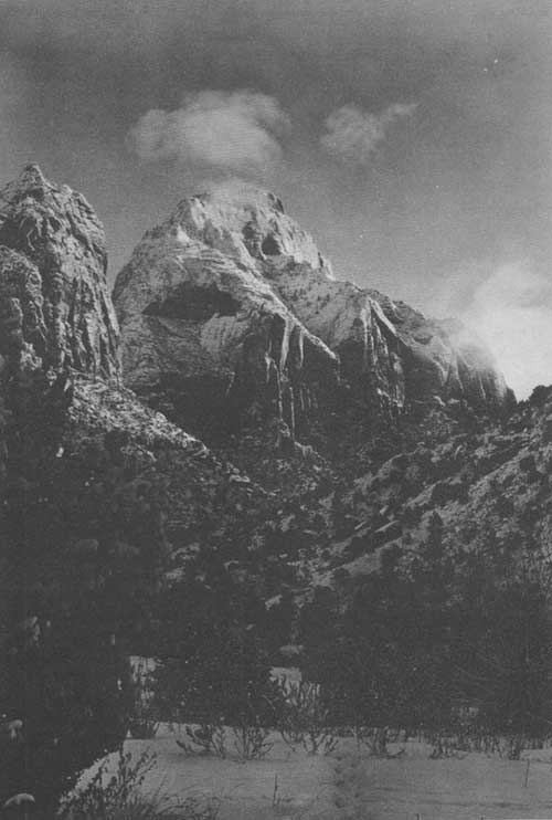
East Temple, Zion Park. Scoyen photo.
HOW TO REACH ZION
Zion National Park is reached from either Cedar City, Utah, on the Union Pacific System, or Marysvale, Utah, on the Denver & Rio Grande Western Railroad. From these points motor-bus service is provided by the Utah Parks Co.
Motorists along the Arrowhead Trail, U. S. No. 91, from Los Angeles to Salt Lake City can reach Zion Park by turning off the main road at Andersons Ranch and going east. Motorists making the approach via the Grand Canyon Highway, United States Highway No. 89, should turn west at Mount Carmel Junction and enter the park at the east entrance via the Zion-Mount Carmel Highway. Road construction in recent years has improved all main and connecting highways to a high standard, most of the roads being hard surfaced.
High-speed de luxe airplane service from all point in the United States to Salt Lake City is available through United Air Lines. Service is also available from Los Angeles by General Air Lines, using the fast and comfortable Douglas planes, with stops at Las Vegas, Nev., and Salt Lake City, Utah. For persons of limited time this service offers a splendid opportunity to visit these parks.
ADMINISTRATION
The representative of the National Park Service in immediate charge of Zion National Park is the superintendent, Preston P. Patraw, whose post-office address is Zion National Park, Utah. All complaints and suggestions regarding service in the park should be addressed to the superintendent.
PARK SEASON
The roads to and within Zion National Park are open, and accommodations are available the entire year. Zion Lodge is open from May 30 to September 30, but the South Entrance Camp, with cafeteria, store, and housekeeping cabins, is operated throughout the year, as is the new South Entrance Free Camp Ground. The Grotto Camp Ground is open from May 1 to November 1.
The four seasons of the year are unusually distinctive in the park, each one being different from the others and affording wonderful, changing spectacles.
During the winter when the levels and slopes are under a blanket of snow, the colored cliffs stand out in startling contrast against the white. In the spring when the snows on the higher elevations are melting, many foaming-white waterfalls are to be seen cascading over the cliff faces or falling sheer from high overhanging niches. Some of the waterfalls have a sheer drop of nearly a thousand feet. The fall months of the year bring the most delightful weather; clear, sparkling days are the rule, the sky is deepest blue, and the deciduous trees of the valley floor and slopes take on variegated coloring. The blue sky, the whites, bluffs, and reds of the cliffs, and the yellows and reds of the deciduous foliage create a truly marvelous color effect.
NATURALIST SERVICE
SUMMER SEASON
Ranger naturalists conduct parties into the field for nature study twice daily, leaving the Temple of Sinawava at 9 a. m. and 3:15 p. m. Evening lectures on the natural features of the park are also given daily at the public auto camp and Zion Lodge by members of the educational division.
The National Park Service has established an official information office and museum at the Grotto Camp Ground. Here park visitors may secure information and publications regarding this and other national parks free of charge. A collection of geological, animal, insect, reptile, and plant-life specimens is on exhibit in this building.
All park visitors are urged to avail themselves of this educational service. Schedules of nature guide trips, lectures, and other activities are posted in public places throughout the park. The educational service is furnished free of charge by the Government, and all information given out is authentic.
| <<< Previous | <<< Contents>>> | Next >>> |
1936//sec2.htm
Last Updated: 20-Jun-2010