|
ZION
BRYCE CANYON
Circular of General Information 1936 |

|
BRYCE CANYON NATIONAL PARK
Bryce Canyon National Park was established September 15, 1928, under authority of the acts of Congress approved June 7, 1924, and February 25, 1928. Under the former act authority was given for the creation of the Utah National Park, to take in the area then included in the Bryce Canyon National Monument, upon the fulfillment of certain conditions. Before these conditions were met Congress passed its 1928 act changing the name of the park to Bryce Canyon National Park and nearly doubling the area contained in the monument. The canyon had been reserved as the Bryce Canyon National Monument by presidential proclamation June 8, 1923, pending consideration for national park status and the passing of the necessary legislation to effect this.
Under congressional authority of June 15, 1930, President Hoover by proclamations dated January 5, 1931, and May 4, 1931, added 22,320 acres to the park. The total area is now 35,240 acres, or 55 square miles.
The delay in bringing the park into the system after the passage of the first act was the condition it contained that it would not become effective until all of the private land holdings within the proposed park boundaries had been deeded to the Government. The transfer was finally accomplished on September 15, 1928, and the park formally dedicated to public use the following day. The details of the transactions by which these holdings were turned over to the Government form a very interesting chapter in the history of conservation.
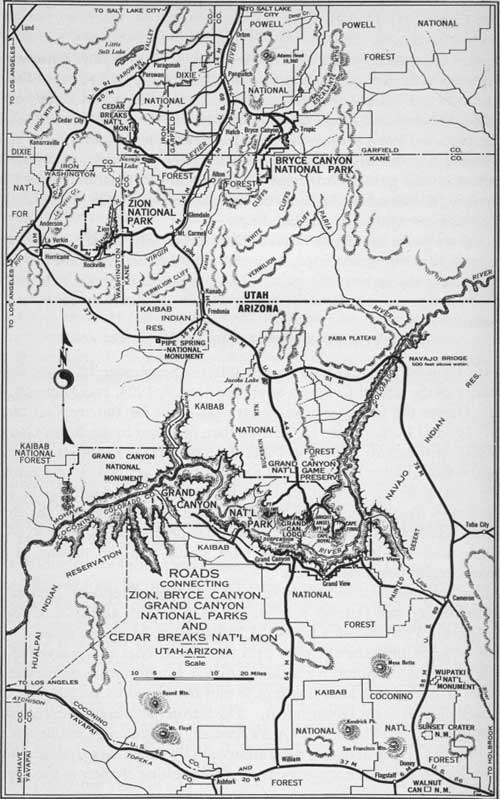 ROADS CONNECTING ZION, BRYCE CANYON, GRAND CANYON NATIONAL PARKS AND CEDAR BREAKS NATIONAL MONUMENT, UTAH-ARIZONA (click on image for a PDF version) |
Bryce Canyon National Park includes some of the most interesting exposures of the Pink Cliff formation. The rocks which are present in this formation are among the most colorful of any forming the earth's crust. The major beauty spots of the area are found where forces of erosion have cut back into the plateau, forming amphitheaters or wide canyons filled with pinnacles and grotesque forms.
The Yellow Creek, Sheep Creek, and Willis Creek sections are all magnificent and have won high praise from those who have seen them. Bryce Canyon, however, is the most spectacular and best known of all the wonders, and, due to the fact that the original park area included only this one canyon, the park takes its name from this feature. The canyon was named after Ebenezer Bryce, a Mormon pioneer, who was the first to settle near its mouth in the early seventies, and not after the famous English statesman.
In reality Bryce is not a canyon; rather it is a great horseshoe-shaped bowl or amphitheater cut by erosion into the Paunsaugunt Plateau and extending down a thousand feet through its pink and white marly limestone. The character of the area is well indicated by the Paiute Indian name, "Unka-timpe-wa-wince-pock-ich", which is translated as, "red rocks standing like men in a bowl-shaped canyon." The amphitheater is 3 miles in length and about 2 miles wide, and is filled to the brim with myriads of fantastic figures cut by weathering influences, chiefly by running water, wind, and changes in temperature. Ages have been consumed in their making and even now they are undergoing change, probably as rapidly as at any other time. The older forms are gradually crumbling, and new ones are slowly appearing from the freshly attacked walls. That the rim of the canyon is gradually receding is shown by the large number of trees that have been undermined recently, and, now, either are precipitated into the canyon below or rest insecurely near the top of the cliffs.
Words can never convey an adequate conception of the fantasy and beauty of Bryce Canyon. It must be seen to be completely realized. From the countless variety of forms in the canyon it would seem that the imagination of some titanic sculptor had run riot and cut into the soft limestone every figure and shape known to or dreamed of by man. Domes, spires, and temples predominate, decorated in all the colors of the spectrum but with reds, pinks, and creams predominating.
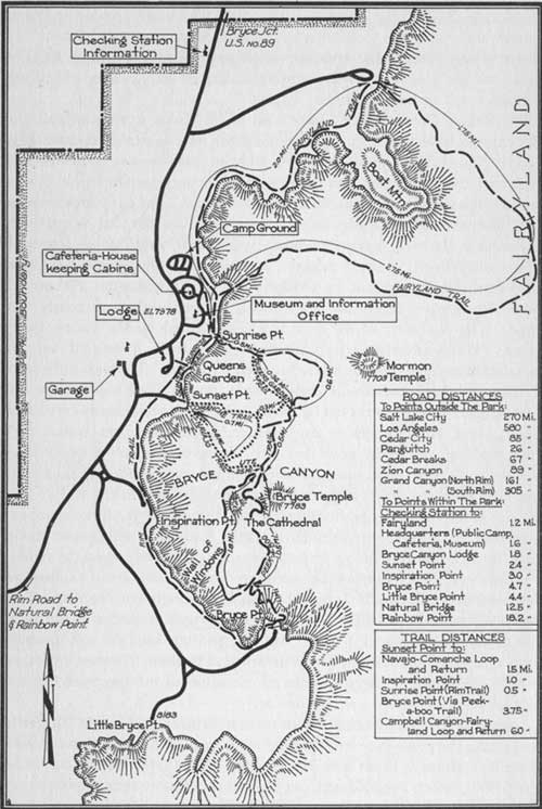
A series of fine horseback and foot trails have been built in the interesting area under the rim. No visitor should leave until he has had close-up views of the formations. Trails lead into Queen's Garden, the Silent City, Fairyland, Wall Street, Peek-a-boo Canyon, and other more remote points, each with its well-named peculiar and distinctive forms. Trails are all easily traveled; horseback trips can be arranged in half- or full-day units to suit the individual.
Portion of Bryce Canyon National Park.
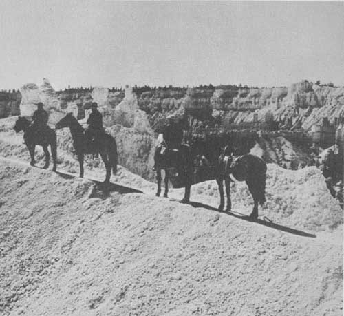
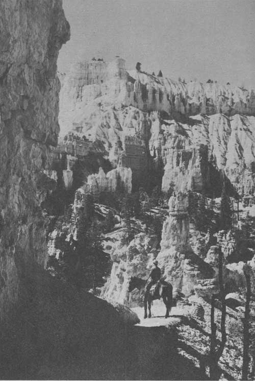
Horseback party on East Rim Trail. Scoyen photo.
The National Park Service has completed a fine road, which follows the high rim the full length of the park plateau, with short spurs to scenic view points. Twenty miles of paved road now lead to Inspiration Point, Bryce Point, Little Bryce, the Natural Bridge, and Rainbow Point, at the plateau's end. A Government ranger naturalist conducts an auto caravan over this route every afternoon during the summer season, leaving Bryce Canyon Lodge at 2:30 o'clock.
Each evening an illustrated lecture is given at Bryce Canyon Lodge by a member of the staff, who also conducts a short hiking trip into Bryce Canyon, leaving Sunset Point every morning of the summer season at 9 o'clock.
Visitors are urged to use these facilities which are provided free of charge by the Government.
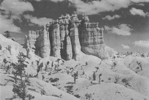
The Fairy Temple, Bryce Canyon. Grant photo.
GENERAL INFORMATION
Bryce Canyon National Park is administered as a unit with Zion National Park and Cedar Breaks National Monument. The representative of the National Park Service in immediate charge is the superintendent of Zion National Park, Preston P. Patraw, whose post-office address is Zion National Park, Utah. All complaints and suggestions regarding service in the park should be addressed to him.
Information concerning the park is available at the ranger station located near the public auto camp. Booklets regarding the national parks are also available there.
The season at Bryce Canyon depends entirely on weather conditions and the park is generally closed during the winter months. Bryce Canyon Lodge is open from May 30 to September 30, and the length of the camping season will depend on weather conditions.
For those not carrying their own equipment and desiring to visit the park after the closing dates of the lodge and camp, there are camps near the park where fairly good accommodations can be found at any time of the year.
Stop-overs on any of the tours quoted on pages 32 and 33 are permitted without additional transportation expense, the only extra cost being for meals and lodging at Bryce Canyon Lodge.
An attractive free public auto camp is maintained by the Government. Pure water is available, and sanitary conveniences have been provided. Groceries and campers' supplies may be purchased in the store at the Bryce Camp.
HOW TO REACH BRYCE
In order to reach Bryce private motorists should leave the main highway, United States Highway 89, 7 miles south of the town of Panguitch. Turning to the east the road follows up Red Canyon, a brilliantly colored little gorge which is often mistaken for Bryce Canyon itself. The approach to Bryce is unusual; no evidence of the canyon is visible until the visitor walks on to the rim and suddenly has revealed to him the great sight in all its breath-taking beauty.
Improved highways make Bryce Canyon Park easily accessible, except during the winter.
Travelers by rail may reach the park over the Union Pacific System from Salt Lake City to Cedar City, Utah, or Marysvale, Utah, on the Denver and Rio Grande Western Railroad, thence by motor bus to Bryce.
High-speed de luxe airplane service from all points in the United States to Salt Lake City is available through United Air Lines. Service is also available from Los Angeles by General Air Lines, using the fast and comfortable Douglas planes, with stops at Las Vegas, Nev., and Salt Lake City, Utah.
Inspiration Point from a turn in the trail. Scoyen photo.
| <<< Previous | <<< Contents>>> | Next >>> |
1936//sec3.htm
Last Updated: 20-Jun-2010