|
ZION
BRYCE CANYON
Circular of General Information 1936 |

|
GENERAL INFORMATION RELATING TO GEOLOGY OF ZION AND BRYCE CANYON NATIONAL PARKS1
1By Dr. H. E. Gregory, U. S. Geological Survey.
REGIONAL FEATURES
In Zion and Bryce Canyon National Parks the type of scenery peculiar to the plateaus of southern Utah and northern Arizona attains its most complete expression. Layer upon layer of shales and sandstone have been carved into architectural forms, astonishingly alike for size and color. The long stretches of even skyline seen on approaching the parks from Cedar City (west), Panguitch (north), and Grand Canyon (south) give an impression of extensive flat surfaces that terminate in lines of cliffs, but viewpoints within the parks reveal a ruggedness possessed by few other regions. The canyons are so narrow, so deep, and so thickly interlaced, and the edges of the strata so continuously exposed that the region seems made up of gorges, cliffs, and mesas intimately associated with a marvelous variety of minor erosion forms. The parks might be considered as mountainous regions in which departures of many thousand feet from a general surface are downward rather than upward.
The canyons and adjoining terraces are spectacular illustrations of erosion. They show with diagrammatic clearness the work of running water, rain, frost, and wind, of ground water and chemical agencies active throughout a long period of time. The horizontal tables and benches, broken by vertical lines that in distant view appear to dominate the landscape, are normal features of erosion of plateau lands in an arid climate. The tabular forms are the edges and surfaces of hard strata from which softer layers have been stripped. The vertical lines mark the position of fractures (joints)—lines of weakness which erosion enlarges into grooves and miniature canyons. As they entrench themselves in horizontal layers of rock that vary in resistance to erosion, the master streams and their tributaries are developing stairlike profiles on their enclosing walls. Cliffs in resistant rocks and slopes in weak rock constitute risers and treads that vary in steepness and height with the thickness of the strata involved. Thus near the south entrance to Zion Park the edge of a layer of hard conglomerate is a vertical cliff, its top a platform. Above this platform a long slope of shales, broken by many benches developed in hard beds, extends upward to the great cliff faces of West Temple and the Watchman. In front of Zion Lodge a slope of weak shales leads upwards to a cliff of resistant sandstone above which a slope of shale extends to the vertical wall of Lady Mountain. In Bryce Canyon the rim road is on the highest tread of a giant rock stairway that as viewed from Rainbow Point leads downward in steps 30 to 400 feet high to the flat lands 3,000 feet below.
The streams at work in the parks, though relatively small, have steep gradients, including rapids and waterfalls, and are supplied with disintegrated rock material swept from the ledges by torrential rains about as fast as formed. They are therefore powerful agents of erosion, especially in times of flood. The fresh, sharp, angular profile of mesas, ridges, and canyon walls and the extensive areas of bare rock are maintained by the rapid down-cutting and prompt removal of rock waste. The resulting land forms reflect the aridity and the topographic youth of southern Utah and contrast strongly with the rounded hills, the broad valleys, the plant-covered slopes, and the deep soils of more humid regions.
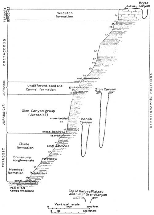
Generalized section of sediments in Zion and Bryce Canyons.
(Note XVI International Geographical Congress, Guide Book 18,
1932. H. E. Gregory.)
(click on image for a PDF version)
GEOLOGIC HISTORY
A large part of geologic history is revealed in the canyon walls of Zion and Bryce Canyon National Parks. Just as Grand Canyon is the best known record of ancient geologic history, Zion Canyon records most clearly the events of medieval geological time, and Bryce reveals much of modern geologic history. The story of Zion begins where that of Grand Canyon ends, and ends where Bryce begins. The rocks exposed in these three national parks incorporate the records of a billion years.
The consolidated sedimentary rocks exposed within Zion and Bryce and in the region that lies between these national parks are assigned by the geologists to the Triassic, Jurassic, and Cretaceous periods of Mesozoic time ("middle age") and to the Eocene period of Tertiary time. Rocks of Permian age underlie the Triassic near the southwest border of Zion, and lavas, gravels, and lake beds overlie the Tertiary in several places. A study of these rocks shows that the geography, the plant life, and the animal life of each of these periods were unlike those of previous periods or of later periods; that during the last 200,000,000 years the region comprising the parks has witnessed many changes in landscape and climate. At times it was covered by the sea, at other times broad rivers traversed its surface, and at still other times it was swept by desert winds. Most of the rocks were laid down by water as gravel, sand, mud, and limy ooze. They have been converted into solid rock by the weight of layers above them and by lime, silica, and the iron that cement their grains. Embedded in the rocks are fossil sea shells, fish, trees, snails, and the bones and tracks of land animals that sought their food on flood plains, in forests, or among sand dunes. The most conspicuous remains are those of dinosaurs—huge reptiles that so dominated the life of their time that the Mesozoic is known as the "age of dinosaurs."
For convenience of study and description, the rock strata that constitute geologic eras are subdivided into groups known as "formations" which differ from each other in such features as color, mineral content, thickness, and areal extent of individual layers, and kinds of fossils. Thus, in the Zion Canyon region the Triassic period includes the Moenkopi, the Shinarump, and the Chinle formations; the Jurassic period, the Navajo, the Carmel, and the Morrison formations at Bryce Canyon; the Cretaceous period includes the Dakota, the Tropic, the Wahweap, the Straight Cliffs, the Kaiparowits formations; and the Tertiary period, the Wasatch formation (Pink Cliffs). Though conspicuously displayed in Zion and Bryce Canyon National Parks and their immediate vicinity, none of the formations listed is confined to the parks. Most of them are represented else where in Utah, also in Nevada, Arizona, New Mexico, and Colorado.
The conditions under which these widespread formations were laid down are shown by the character of the bedding fossils and the kinds of materials of which they are made. Each formation reveals in detail the physical geography, the climate, the fauna, and the flora of the time of its origin.
The enormous pile of rocks that constitute the formations of Triassic, Jurassic, Cretaceous, and Tertiary periods were not continuously deposited. At times the sea bottoms, the low-lying plains, and the inland basins which served as resting places for stream-borne material were uplifted and erosion replaced deposition; the consolidated rocks laid down in one period were worn into sands, muds, and gravels, and redistributed to form rocks of a later period. At other times the region that includes Zion and Bryce Canyon National Parks was below sea level and sediments were deposited. The end of this periodic uplift and subsidence was the final retreat of the sea in the Cretaceous and the deposition in Tertiary times of sandy limestone along streams and in lakes of a new-made land not far above sea level.
The accumulation of some 8,000 feet of strata of Mesozoic and Tertiary age, mostly sandstones, on top of 4,000 feet of Paleozoic beds exposed in Grand Canyon may be considered the first of three major events in the development of the marvelous landscapes of the Zion-Bryce region; it provided the material from which the huge scenic features were later carved. The second event was a regional uplift which elevated the previously low-lying top beds of the series (Wasatch, Pink Cliffs) to a height of nearly 2 miles above sea level. Essentially Zion Park is a part of an enormous block, broken from the adjoining area of the earth's crust by faults. The western border of this block, extending from central Utah south across Grand Canyon, is the great earth fracture known as the Hurricane fault. Part of the wall developed by this fault remains as the Hurricane Cliffs crossed by the Highway from Zion Canyon to Toquerville and extending northward to Cedar City. The eastern border of the block is the Sevier fault along the cliffs east of Mount Carmel, Glendale, and Hatch. Bryce Canyon National Park likewise is part of a block bounded on the west by the Sevier fault and on the east by the Paunsaugunt fault which raised the Wasatch beds in Table Cliff Plateau high above those at Inspiration Point. The uplift of those great earth blocks whose surfaces were previously near sea level was the third major event in the history of the parks; it provided conditions favorable for the vigorous erosion still in process. Before the uplift the streams were doing little work. They were flowing in broad shallow valleys of gentle gradient like those on the plateau surfaces near Cedar Breaks and east of Red Canyon. In consequence of the uplift they became strong swift streams that were able to cut deeply into the underlying rock and carry to the Virgin and the Paria and on to the Colorado and the Pacific all the land waste available. In the process of carving the former high lands the streams have removed many cubic miles of rocks which if replaced would fill the present canyons and build up their bordering lands to the level of the lofty Markagunt and Paunsaugunt plateaus. The gigantic features of Zion and Bryce Canyon National Parks mark a stage in the process of erosion that began long ago and which if continued without interruption will convert the present rugged landscape into plains near sea level.
DISTINCTIVE FEATURES OF ZION CANYON
The crowning glory of Zion Park is Zion Canyon, the best known example of a deep, narrow, vertically walled chasm readily accessible for observation. Zion Canyon through much of its course is about as deep as it is wide, though in the narrows it is 2,000 feet deep and less than 50 feet wide. On its floor is an automobile highway, continued upstream by trails.
Zion Canyon was made by the north fork of Virgin River, the stream which now flows through it. It is not a crack in the earth's crust or a gorge scooped out by glacier ice and conveniently placed to serve as a runway for rain that falls on the surrounding highlands. Before the Virgin began to flow there was no canyon. During the long period since its course was established the river has slowly deepened its channel and extended it headwards until its original shallow valley has become a long narrow trench between towering walls. Though now deeply entrenched in the rocks of the Kolob Plateau, the river maintains substantially its original pattern. It flows in the same direction, and the curves and straight stretches of its present walls duplicate the meanders of the stream when it flowed some 5,000 feet above its present level.
For many thousand years the Virgin and its tributaries have been busy with two tasks; namely, deepening their channels and transporting material weathered from the canyon walls. At present the Virgin carries away from the park each year about 3,000,000 tons of ground-up rock at an average rate of 180 carloads a day. For such effective work the many-branched Virgin seems incompetent. But though relatively small in volume, this stream system falls nearly 70 feet to the mile (nine times the fall of the Colorado in Grand Canyon) and is at work on rock, chiefly sandstone, that disintegrates with exceptional ease. Many tributaries are on bare rock, little retarded by vegetation, and are fed by short but violent showers. Consequently, they are brought to flood stage not only seasonally, but with each period of heavy rainfall. Because they flow only in response to showers, the smaller tributaries are unable to cut channels as deep as the perennial master stream. From their mouths high on the canyon walls, they descend as waterfalls.
Though they are primarily responsible for the depth and position of the canyons, the Virgin itself and the other streams heading on the adjoining plateaus are only incidentally concerned with the detailed carving that makes Zion Canyon unique. The walls are retreating in consequence of ground water which emerges as springs and seeps, of rain which falls directly into the canyon, of water that spills over the rim, of frost and tree roots which pry off slabs, and of chemical agencies which weaken the rock by the removal of the cement about individual grains. Continuous sapping at or near the contact of the porous Navajo sandstone and the more impervious Chinle shale has developed alcoves in the canyon walls at Wiley Retreat, the Stadium, Weeping Rock, Emerald Pool, Birch Creek, Oak Creek, and elsewhere.
In the development of the amazing variety of architectural features on the canyon walls, the composition and structure of the Navajo formation have served as controlling guides. In addition to the bedding planes—horizontal, oblique, and curved surfaces—the Navajo has developed parting planes (joints) that extend downward for short distances or pass through the formation from top to bottom. These bedding planes and joints determine the shape and size of the blocks that spall off from the towering cliff walls. Blocks embedded in the cliffs, blocks surrounded by open joints, blocks partly detached, blocks that rest precariously on some temporary support, and blocks that have fallen to the talus below indicate steps in the retreat of the canyon walls. Unlike that of humid regions, this type of erosion progresses from below upward; it causes the canyon to widen and still retain its vertical walls.
DISTINCTIVE FEATURES OF BRYCE CANYON
In its regional setting Bryce Canyon National Park is the southeastern border of the extensive Paunsaugunt Plateau. It comprises two areas of strongly contrasted topography that meet in a line that marks the rim of the plateau and the top of its bordering cliffs. Back from the rim the plateau surface on which the park buildings and the automobile roads have been constructed is generally flat land traversed by broad, shallow valleys in which erosion is inconspicuous. Below the rim erosion has produced a region of remarkable ruggedness. It might naturally be supposed that the beautiful amphitheater at the head of Bryce Canyon had been carved by waters pouring down from the plateau above. But the plateau streams contribute nothing; they flow away from the rim. The chief sculpturing agents are the rain and snow that fall directly into the canyon. In producing the amazing variety of erosion features the streams have been aided by frost that pries fragments from the cliffs and by chemical agencies that decompose the rock and supply its vivid color.
The development of the park landscape was made possible by movements within the earth's crust which brought originally low-lying strata to an altitude exceeding 8,000 feet. Streamways on the flat top of this uplifted block were little affected, but with greatly steepened gradients streams around the borders of the newly made plateau became powerful. The Paria and its swiftly flowing tributaries have cut deeply into the face of the Paunsaugunt and carried billions of tons of ground-up rock to the Colorado. At the present time erosion by Bryce Creek, Yellow Creek, Willis Creek, Podunk Creek, and many smaller streams, is causing the plateau face to retreat northwestward, and these streams are taking into their drainage areas channels that formerly carried waters northward to Sevier River.
The drab colored landscape along the southeast border of the park has been developed in alternating beds of shale, coal, and sandstone (Cretaceous age); in the resulting erosion forms, slopes, mounds, rounded ridges, and valleys with inclined or steplike sides predominate. The brightly colored rocks that form the topmost cliffs and terminate abruptly in such headlands as Steamboat Mountain, Bryce Points, and Rainbow Point are resistant limestones of Tertiary age (Wasatch formation). They erode as vertical walls (Pink Cliffs) which weathering has developed into the astonishing display of architectural forms that make Bryce Canyon distinctive.
WILDLIFE
Visitors to Zion and Bryce Canyon National Parks will be surprised at the interesting and varied forms of wildlife to be found there. The common large game animals are the Rocky Mountain mule deer. They are quite numerous and can often be seen by park guests, though in the summer they usually range the rims of the canyons. Bighorn, present in Zion, are not often seen except in winter, when they are driven from the higher elevations by cold and snow. At times they have been seen in bands numbering up to 18 along the Zion-Mount Carmel Highway, although recent observations indicate that they are less numerous than formerly. Signs of mountain lion are often found in the park and occasionally a glimpse of the animal is caught. Coyotes are fairly numerous, but are more often heard than seen. Bobcat tracks are frequently observed in mud or snow; the cats, however, are rarely visible. Many small animals, such as porcupines, marmots, chipmunks, and gray squirrels, are abundant and can be seen almost everywhere.
Bird life is interesting and the visitor will find most of the arid or semi-arid types in the park, together with a few forms typical of areas of heavier rainfall. The rare water ouzel can be numbered among the latter. Probably the most absorbing of all to those who are acquainted with them are the many types of lizards, such as the scaly lizard, the Bailey collared lizard, and the rare leopard lizard.
ACCOMMODATIONS AND EXPENSES
Attractive lodges are operated by Utah Parks Co. in both Zion and Bryce Canyon Parks. They consist of central buildings and cabins of "standard" and "de luxe" types. The latter have private bath, porch, and fireplace. De luxe cabin rates, European plan, are $6 per day for 1 person, $8.50 for 2, and $10.50 for 3 persons, and the standard lodge cabin rates are $2 per day for 1 person and $3 per day for 2 persons. A 15 percent discount is allowed for a stay of 1 week or longer. Meals in lodge dining room are table d'hote, breakfast and luncheon $1 each and dinner $1.25. Children under 8 years of age are allowed half rates for meals. Zion and Bryce Canyon Lodges are open from May 30 to September 30.
Evening entertainments are provided daily in the recreation rooms at both lodges by talented student employees. Park ranger naturalists appear on these programs with illustrated lectures.
Housekeeping camps at both parks provide cafeteria, store, housekeeping cabins, and sleeping tents. For 1 or 2 persons the rates are $2.25 in the standard housekeeping cabins, $2 in converted housekeeping cabins, and 75 cents in sleeping tents; for 3 or 4 persons in standard housekeeping cabins, $2.75 per day, exclusive of bedding and linen. The housekeeping cabins are electrically lighted and are equipped with double beds, cooking stove, table, sink, shelves, and chairs. The sleeping tents have 2 military cots. Bryce Camp is open from about May 30 to September 30. Zion Camp is operated throughout the year.
POST OFFICE AND COMMUNICATION SERVICE
Each lodge is provided with post office, telegraph, and long-distance telephone service. The post office address for Zion Lodge is Zion National Park, Utah, and for Bryce Canyon Lodge, Bryce Canyon National Park, Utah.
MISCELLANEOUS SERVICE
In each lodge, fountain service is available. A full line of photographs and hand-colored views of Zion and Bryce Canyon Parks is on sale, and laboratories are maintained for developing and printing pictures.
Curio stores, making a specialty of Indian handicraft, including silver work, baskets, and Navajo rugs, are operated.
Garage service, including storage, repairs, tires, batteries, gasoline, and oil is provided by the Utah Parks Co. in each park during the regular lodge season.
A registered nurse is on duty at each lodge when it is in operation.
An attractive swimming pool is located at Zion Lodge.
In the cabin camps, food supplies may be obtained, as well as curios, post cards, etc.
PUBLIC CAMP GROUNDS
Free public camp grounds for visitors carrying their own equipment are maintained in each park. In Zion the Grotto Camp Ground is open May 1 to November 1; the South Entrance Camp Ground all year. The Bryce Public Camp Ground remains open as long as weather conditions permit. Winter conditions prevailing at this elevation of 8,000 feet normally make camping impracticable from November until the first of May.
SADDLE HORSES
Saddle horses may be hired for $1.50 for 2 hours or less, $3 for 4 hours or less, and $5 for 8 hours. Escorted trips to the East or West Rim of Zion Canyon and to Bryce Canyon Natural Bridge are made daily and cost $5 a person. Escorted half-day horseback trips to The Narrows or Angels Landing in Zion Park and into Bryce Canyon at Bryce Park cost $3. Special guides, if available, may be obtained for $5 a day or $3 for a half day or less. Riding habits may be rented at the lodges.
SIDE TRIPS BY BUS
An automobile trip from Zion Lodge to the Temple of Sinawava may be made for $1.
In Bryce Canyon Park the Rim Road trip by motor, including Bryce, Little Bryce, and Inspiration Points, Natural Bridge, and Rainbow Point costs $3.
SPECIAL TRIPS
Motor-bus transportation to Zion National Park, the Kaibab Forest, the North Rim of the Grand Canyon, Cedar Breaks, and Bryce Canyon is available from Cedar City, Utah, on the Union Pacific System.
The following trips and rates have been authorized, available during the period June 1 to September 25:
| TOUR NO. 1 | |
| 1-day tour, Cedar City to Cedar Breaks National Monument and return, automobile transportation only, per person | $7.50 |
| "All-expense" tour, including transportation and two meals | 9.75 |
| TOUR NO. 2 | |
| 1-day tour, Cedar City to Zion National Park and return, automobile transportation only, per person | $10.00 |
| "All-expense" tour, including transportation and two meals | 12.25 |
| (Operated only for minimum of 2 persons. Available all year.) | |
| TOUR NO. 3 | |
| 2-day tour, Cedar City to Bryce Canyon National Park, via Cedar Breaks National Monument and return, automobile transportation only, per person. | $15.75 |
| "All-expense" tour, including transportation, meals, and lodging | 22.75 |
| TOUR NO. 4 | |
| 4-day tour, Cedar City to Cedar Breaks National Monument, Bryce Canyon National Park, Mount Carmel Highway, Zion National Park and return, automobile transportation only, per person | $21.50 |
| "All-expense" tour, including transportation, meals, and lodging | 35.75 |
| TOUR NO. 5 | |
| 6-day tour, Cedar City to Cedar Breaks National Monument, Bryce Canyon National Park, Kaibab Forest, Grand Canyon National Park, Mount Carmel Highway, Zion National Park and return, automobile transportation only, per person | $35.00 |
| "All-expense" tour, including transportation, meals, and lodging | 58.75 |
| TOUR NO. 6 | |
| 2-day tour, Cedar City to Grand Canyon National Park (North Rim), via Cedar Breaks National Monument, Bryce Canyon National Park, and Kaibab Forest; one-way tour, automobile transportation only, per person | $21.50 |
| "All-expense" tour, including transportation, meals, and lodging | 31.00 |
| TOUR NO. 7 | |
| 2-day tour, Grand Canyon National Park (North Rim), to Cedar City, via Kaibab Forest, Mount Carmel Highway, and Zion National Park; one-way tour, automobile transportation only, per person | $21.50 |
| "All-expense" tour, including transportation, meals, and lodging | 31.00 |
"All-expense" charges shown herein include cost of automobile transportation, also meals and sleeping accommodations at lodges en route; they do not include any meals or lodging at Cedar City except luncheon or dinner, as the case may be, on outbound trip.
For motor-bus transportation half fare will apply for children of 5 years and under 12; children under 5 years will be carried free when accompanied by parent or guardian. Arrangements must be made with the lodges for children's rates for table d'hote meals which will be furnished children under 8 years of age at half rates.
Six-passenger touring cars may be chartered for any scheduled tour for exclusive use of parties. The rate for the exclusive use of a 6-passenger touring car is a minimum of three full fares for the respective trips plus $17.50 per day or part thereof. Special cars may be secured for any length of time for any tour or combination of tours desired. Rates upon application at the office of the Utah Parks Co., Cedar City, Utah.
This booklet is issued once a year and rates mentioned herein may have changed slightly since issuance, but the latest rates approved by the Secretary of the Interior are on file with the superintendent and park operator.
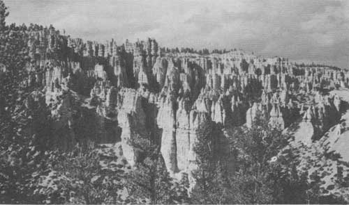
A view of Sunrise and Sunset Points from Cathedral Ridge.
REFERENCES
ALBRIGHT, H. M., and TAYLOR, F. J. Oh! Ranger. A book about the national parks. Dodd, Mead & Co.
GREGORY, H. E. Colorado Plateau Region; Guidebook No. 18, for the International Geological Congress, XVI Session. Superintendent of Documents, Washington, D.C.
KANE, J. F. Picturesque America. Frederick Gumbrecht, Brooklyn, N. Y. Zion and Bryce, pp. 75-82.
KELLEY, E., and CHICK, W. D. Three Scout Naturalists in the National Parks. Brewer, Warren, and Putnam.
MCKEE, EDWIN D. Ancient Landscapes of the Grand Canyon Region. Privately published by the author, Grand Canyon, Ariz.
ROLFE, MARY A. Our National Parks. A supplementary reader on the national parks for fifth- and sixth-grade students. Benj. H. Sanborn, Chicago.
SCOYEN, E. T., and TAYLOR, F. J. Rainbow Canyons. Stanford University Press.
WILBUR, R. L., and DUPUY, W. A. Conservation in the Department of the Interior, Superintendent of Documents, Washington, D. C.
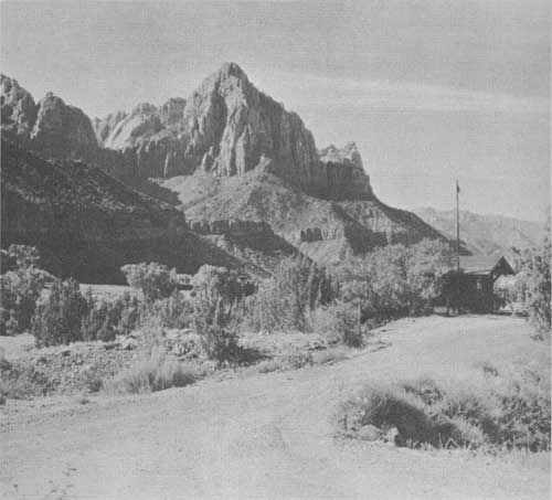
The Watchman looks down on the checking entrance station. Grant photo.
| <<< Previous | <<< Contents>>> | Next >>> |
1936//sec4.htm
Last Updated: 20-Jun-2010