

|
FORT RALEIGH National Historic Site |
 |
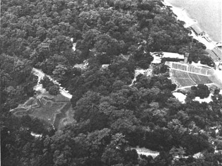
Aerial view of the restored fort.
Guide to the Area
THE BOUNDARY STOCKADE. You enter Fort Raleigh National Historic Site between two small block houses built of logs, constituting a part of the boundary stockade. This stockade is of modern construction, and originally it marked the boundary of the 16.45-acre tract of the Roanoke Island Historical Association which was administered as a North Carolina State historical park between 1935—41. In 1951, one side of the stockade was relocated and the area of the national historic site was increased to 18.50 acres. Although quite modern and located along a modern boundary, it recalls that Governor White on returning to the site of the colony in 1590 found it fortified by a palisade of tree trunks (location still unknown) and hence creates a sense of stepping upon hallowed ground upon entering the gateway. The feeling is certainly justified, because the 18.50 acres lie on the entrance side of the fort and even if the fort had held only Grenville's 15 men they would have trod this ground many times. As there were 108 persons in the first colony under Lane, who built the fort, and 150 in the "Lost Colony," the use of the area near the entrance to this fort must have been considerable.
SYMBOLIC LOG HOUSES. Inside the boundary stockade you will pass a number of log houses, all of modern construction, serving various utilitarian purposes. As the true location and physical appearances of the settlers' houses of 1585—87 are unknown, the National Park Service plans to remove these log structures when their present uses have been served.
RESTORED FORT. The historic object of chief interest at Fort Raleigh is the fort built by Ralph Lane during 1585—86 and called by him "the new Fort in Virginia." As the settlers of the Lost Colony of 1587 are known to have rebuilt for their own use the houses which Lane's men constructed about the fort, it may be safely assumed that this same fort served them also for a time, at least until they found it necessary to erect the great stockade made of tree trunks that Governor White found enclosing their settlement area in 1590.
In an earlier part of this book, the history of the fort between 1586 and 1896 has been traced. During 1935-46, National Park Service historians made intensive historical studies of all available documentary and map data relating to the fort. They concluded that the fort surveyed for the Roanoke Colony Historical Association, in 1896, was Lane's fort and surmised that its shape was similar to that of the fort built by Lane in Puerto Rico in 1585. They could only surmise this because, unlike Lane's fort in Puerto Rico which is shown in a drawing by John White now in the British Museum, no picture or plan of Lane's fort on Roanoke Island has survived. National Park Service archeological work carried on under the direction of Archeologist J. C. Harrington during the summers of 1947, 1948, and 1950 established the truth of the conjectures of the historians. The true shape of the fort was made known. Enough of the fort moat, or ditch, was found intact to justify the restoration of the fort, and valuable artifact materials were recovered at the fort site and west of the fort entrance.
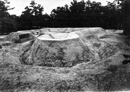
The fort during the work of restoration.
As the fort stands today, the greater part of the ditch is the original moat of 1585—86, but the parapet has been restored. In the interval between 1586 and 1947, wind, rain, and snow had washed the parapet of the fort into the fort ditch. Leaf mold had also accumulated there. Archeological studies of these materials indicated that the fort was of great age. After careful archeological work at the fort and its environs in 1947 and 1948, it was decided in 1950 to restore the fort which had been shown to be the remains of an Elizabethan work. The earthen fill was removed from the ditch, or moat, of the fort and was placed where the parapet had been and the parapet built up once more. Except for the fact that the archeologists worked slowly with painstaking care to follow the lines of the original ditch, and Lane's soldiers must have worked rapidly with shovels, the new and the old process of building the parapet of the fort must have been much the same. The amount of earth in the original ditch, as disclosed through archeological methods, determined the height of the parapet, which was shaped in accordance with normal angles of repose and data from contemporary manuals on fortification such as Paul Ive's, The Practice of Fortification, (London, 1589).
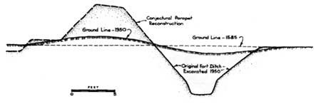
Typical section through the original fort ditch and the recon structed
parapet.
Lane's fort, as revealed and restored by the archeologist, is basically a square, with pointed bastions built on two sides of the square and an octagonal bastion built on the third side of the square. This last-mentioned bastion is suggestive of the arrowhead bastion of Lane's Puerto Rican fort as pictured by John White. It is also suggestive of the octagonal bastion shown on the plan of St. George's fort built in Maine by Popham in 1607. As the fort carries the distinctive features of Lane's Puerto Rican fort, the pointed bastions built on the sides of the square instead of at the corners as in later fortification technique (a system either peculiar to Lane or at least quite rare), the conclusion is irresistible that Lane was the original builder.
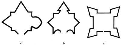
Comparisons of the fort on Roanoke Island with other
forts of the period. (a) The fort on Roanoke Island;
(b) the fort built in Puerto Rico by Ralph Lane; (c) a
conventional fort with corner bastions.
The parapet of the fort encloses an area approximately 50 feet square. The interior had been dug into so many times and in so many places by Indians, later settlers, soldiers of the Civil War period, and by Talcott Williams that the National Park Service archeologist was unable to say for sure what structures had been inside of the fort. Traces of what may have been one long structure or two short ones were found near the center of the fort at right angles to the main entrance. Presumably, there were a well and a powder magazine. The few brickbats found may relate to the footings or chimneys of the structure, or structures, in the fort or to the magazine. The one measurable side of one of the brick fragments found was of the proper gauge to have been of the Elizabethan period, when the sizes of bricks were regulated by law.
The location of the fort, not far from the water's edge, commanding a channel of Roanoke Sound in use for small boats even in later colonial times, bespeaks its purpose of defending the colonists not only against the Indians but also against an always probable attack from Spain. An enemy ship approaching from Port Ferdinando (Hatoraske) or Trinety Harbor, north of Hatoraske, would have come under the guns of the fort, consisting of some brass cannon and at least "four iron fowlers" (light cannon). Some of the cannon fired "iron saker shot," which would be iron balls weighing about 6 pounds. Today, large dunes lie between the fort and the sound and obstruct the view. However, as archeological tests show that the dunes are later than the period of settlement, it is clear that the fort originally commanded a view of Roanoke Sound.
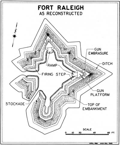
Fort Raleigh as Reconstructed.
PRESUMED LOCATION OF THE SETTLEMENT. As has been indicated, the house sites of the colonists have never been found. They are described as having been decent dwelling houses near the fort and "about" the fort. They were probably built on the ground without basements or firm footings. This would explain the difficulty of finding traces of them. The location of the fort entrance on the west side would suggest that the main settlement lay west of that point, toward the upper end of the island. A more precise statement than this cannot be made at the present time.
 Drawings of one of the Hans Schultes counters, or jettons, found at the fort. The obverse side reads "Glick Kvmt Von Got Ist War" (True good fortune comes from God). |
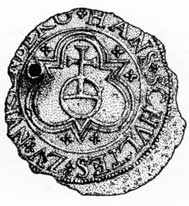 On the reverse side is "Hans Schvltez Zv Nvrenberg." |
THE TEMPORARY MUSEUM. Not far from the fort is a modern log structure used as a temporary museum. Besides housing such objects of historical interest as documents relating to Raleigh's family, pieces of armor, and the rare facsimile reproductions in color of the remarkable water-color drawings made in America by John White during 1585-86, the museum contains objects which were recovered at the fort site and elsewhere on the grounds of the national historic site during the archeological excavations of 1947, 1948, and 1950.
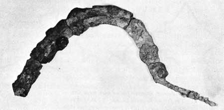
Iron sickle found during the excavations.
Among the many objects brought to light is a wrought-iron sickle found in the very bottom of the fort ditch. Undoubtedly, it was one of the tools used at the time of the building of the fort, because archeological evidence shows that the loose dirt of the parapet of the fort began to wash back into the ditch almost as soon as the fort was completed. Even more interesting, perhaps, are three copper, or brass, counters, popular in Europe for keeping arithmetical accounts during the sixteenth century, which were found inside the fort. They carry the symbols of Tudor England and on one the name Hans Schultes Zu Nuremberg is readable. Schultes is known to have manufactured such counters in Nuremberg between 1550 and 1574, at which time Nuremberg was a center for the making of counters. He undoubtedly made this one for the English trade, as the Tudor symbols indicate. Likewise, of great interest are the fragments of large Spanish olive jars found in the excavations. As the colonists of 1585—86 traded in Puerto Rico and Haiti, in the Spanish West Indies, for goods and supplies on their way to Roanoke Island, it was to be expected that objects of this type would be found.
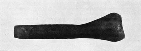
Indian pipe of red clay found at the bottom of the fort
ditch.
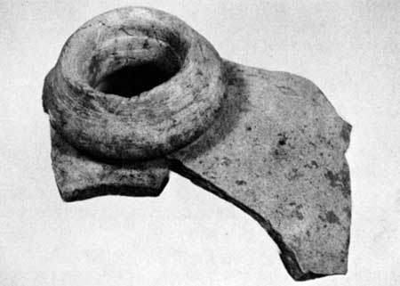
Top of a Spanish olive jar found at the bottom of the fort ditch.
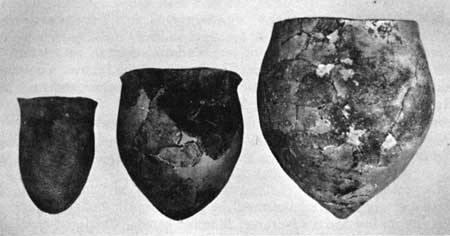
Three clay pots restored from fragments found in the remains of Indian
campfires at various levels in the fort ditch.
Fragments of maiclica were also found, which appear to be either Spanish or Hispano-American. In addition, large iron spikes, buckles, a casement bar and other materials of interest came to light. Indian pottery and traces of Indian campfires found at various soil levels show that the Indians returned to Roanoke Island and inhabited the fort area after the last colonists had left.
THE WATERSIDE THEATER. At the water's edge is the theater of the Roanoke Island Historical Association, in which Paul Green's Lost Colony symphonic drama is given annually during the summer season through the cooperation of the State of North Carolina and the National Park Service.

|

|
Last Modified: Mon, Dec 2 2002 10:00:00 am PDT |