

|
BANDELIER National Monument |
 |
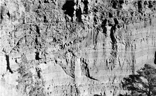
A cross section of sandstone overlain by lava,
Frijoles Canyon.
The Natural Scene
GEOLOGY. The landscape of the Bandelier area is predominantly one of cliffs and canyons; as a visitor to the plateau you will be made conscious of the involved structure and contour of the region in the course of the auto trip over the approach highway. The impression you may get on arrival is of a vast confusion of canyons separated by equally confused mesas and ridges. The topography, however, is not so mixed as first appearance would indicate, for there is a regularity to the pattern of the drainage which becomes apparent from study of a map or aerial photo. The geology, on the other hand, is extremely complex and can be outlined only in general terms in this handbook.
The dominating feature of the landscape is the uplift of the Jemez Mountains, forming the western skyline as one approaches the monument from the east. These mountains are the remains of a great volcano which erupted during the past million years. As seen from a distance, there is very little to suggest a volcano in the profile of the present mountains; only by traveling some 15 miles west of Bandelier into the central valley of the range can the nature of the eruption be visualized. Here is a basin of grassland ringed with forested hills, on a scale so large that its extent is difficult to appreciate. This is the Valle Grande—"great valley" of the Spanish discoverers, who could not have known that they had found one of the largest calderas in the world. Although the Valle Grande now has superficial characteristics of a volcanic crater, there was no single crater here in the days of the eruption—rather a vast dome of a mountain which poured from its flanks such a quantity of lava and other materials that its roof finally fell in. The dimensions of the caldera, a rough oval, are approximately 16 by 18 miles. It is estimated that at least 10 cubic miles of lava and ashes were ejected here to produce the cavity which now exists. The ring of hills around the oval are the remnants of the ancient volcanos perimeter, which remained elevated after the central areas collapsed.
The volcano, then, played the chief role in fashioning the landscape of the Pajarito Plateau. It provided an uplift of the land at the caldera, by the same means establishing a down-slope from the center outwards, along which the lavas of the eruption avalanched in fire and smoke. Interspersed between the flows of heavy lavas were other avalanches and showerings of volcanic ashes in great depth. When cooled and welded together as they are today, they are called tuff. This process of earth-building went on intermittently for many centuries until the volcano had exhausted its violence and had distributed its many cubic miles of outpourings in encircling deposits around its flanks. With the subsidence of volcanism, the great earth-removing force of erosion became the predominant factor in forming the landscape.
The first rains and snows which fell upon this ancestral uplift found relatively smooth slopes descending outward from the rim of the central caldera. These rains and melted snows began to drain downhill, finding whatever slight channels or irregularities there were in the surface. As the centuries passed, the little water-channels became gullies, then ravines, trending east and southeast through the Bandelier quadrant, down the natural fall-line of the Pajarito slopes. In less than a million years, the plateau has eroded into its present form and the drainage pattern of canyons radiating from the Jemez ridge and emptying into the Rio Grande has become well defined. Such canyons as Frijoles, then, are the products primarily of water erosion, etched into a one-time smooth slope of volcanic deposits.
During the early years of this erosion process, the caldera itself became a lake, entrapping the runoff of waters within its circle. This body of water eventually found an outlet to the south, through the guarding rim of the basin, and in its outflow began the present system of canyons of the Jemez River. A modern example of a caldera containing a lake is to be seen in Crater Lake National Park in Oregon, but the Valle Grande Lake had nearly six times as great an area.
Many of the almost sheer canyon walls of the monument provide good cross sections of the lava and ash deposits exposed in cliffs several hundred feet high. In simplest form, these cross sections reveal at their base a flow of lava or basalt, overlain by perhaps 200 vertical feet of tuff, and capped by another flow of lava forming the rimrock of the mesa-top. In most places, the alternating layers of lava and tuff were deposited several successive times, variously distributed, and complicated by later faulting and interim periods of erosion, so that the interpretation of the rock layers is not everywhere as simple as in the example given above.
One difficulty you may encounter in understanding the makeup of the Pajarito cliffs stems from the very different appearance of the two opposite walls of such a canyon as Frijoles. In the north wall, facing the sun, the cliffs stand bold and somewhat barren; in the south and shadowed wall, there are no prominent cliffs, but rather a rough slope of boulders overgrown with trees and brush. Because of this contrast, it might be difficult for you to realize that the two walls are made up of nearly identical rocks. The difference in appearance is due simply to the difference in exposure. The north wall, hot and dry in the sun and subject to extremes of temperature, has never had a heavy vegetative cover and has eroded into a cliff; the south wall, relatively cool and moist, has been able to support a growth of plants which have held and produced soil sufficient to mask the underlying rocks.
As mentioned earlier, the geology of this locality is complicated to such a degree that the foregoing discussion should be considered as only a general outline. The whole story of the Jemez volcano has not yet been worked out in detail, for the eruptive activity was on a scale so vast and involved such complex forces that geologists are continuing to evolve new concepts as new facts come to light.

|

|

|
Last Modified: Sat, Jan 6 2001 10:00:00 am PDT |