

|
BANDELIER National Monument |
 |
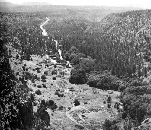
Headquarters area in Frijoles Canyon, showing, from
bottom upwards,
Tyuonyi Ruin, the Big Kiva, the Museum, and the
Lodge.
Guide to the Area
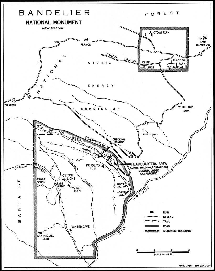
FRIJOLES CANYON. Monument headquarters are at the terminus of the approach road, on the floor of Frijoles Canyon. This center of development is the focal point of activity throughout the year. Listed below are the features of interest to be found in and around the headquarters area; reference to the map (see below) will help to locate the points mentioned.
1. Administration Building and Museum. This building contains a reception information desk manned by park rangers and a lobby from which visitors leave to walk to the ruins. Reference books are available from the monument library on request, and a stock of publications on pertinent subjects is for sale.
The museum occupies a part of the headquarters building. Three rooms of exhibits present Indian artifacts and information on the life and origins of the prehistoric people, and on the modern Pueblo Indians of the vicinity. A visit to the museum is advisable before making a trip to any of the ruins, since the exhibits provide a background against which the ruins are better understood and appreciated.
2. Tyuonyi Ruin lies about 500 yards by trail up the canyon from headquarters. This ruin is one of the principal way-stations on the loop trail over which the trips are routed. Other features on this same loop are an unexcavated ruin, the Big Kiva, Sun House, Cave Kiva, and Long House.
3. Ceremonial Cave is reached by trails either along the Rito or along the north cliffs, approximately 1 mile above headquarters. A walk to this cave is very popular with hikers of modest ambitions, and is particularly rewarding to the photographer. There are a number of tall ladders to climb to reach the cave; consequently, rubber-soled shoes and a degree of caution are recommended.
4. The Upper Falls are downstream from headquarters about a mile and a half. The trail follows the Rito down through some of the handsomest forest glades on the monument, crossing the stream several times. The falls, in a deep lava cleft, are about 80 feet high. The Lower Falls, a quarter-mile farther down, are only half as high. Along the trail between the two falls, a geologically interesting exposure of the canyon wall is conspicuous.
OTOWI SECTION. Two large ruins, Tsankawi and Otowi, are the principal features to visit on this detached section of the monument. The main access road from Santa Fe to monument headquarters passes through this section and close to the Tsankawi Ruin. Distance from this ruin to headquarters is 16 miles.
5. Otowi Ruin lies between Pueblo and Bayo Canyons on a disused road. Inquire of a park ranger before attempting to make the trip.
6. Tsankawi Ruin is reached by a spur road and foot trail branching from State Route 4. At the end of the road, a stand contains booklets for the self-guiding trail which leads up onto the mesa to the ruins, a round trip walk of about three-quarters of a mile.
THE BACK COUNTRY. A network of some 50 miles of foot and horseback trails reaches out from monument headquarters into the roadless southern areas of the monument. Hikers and horseback parties frequently make a loop trip of 2 days, visiting the Stone Lions and Yapashi Ruins, and spending the night at Base Camp in Capulin Canyon, where a National Park Service fire guard is on duty during the summer. The return trip may be made past Painted Cave to the Rio Grande, then up White Rock Canyon to Frijoles Canyon and point of beginning.
ADJACENT POINTS OF INTEREST. The Valle Grande is 15 miles west from the Frijoles Canyon checking station, on State Route 4, toward Cuba, N. Mex. This drive across the Jemez ridge cannot be made in the winter, for the road is never cleared of snow.
Los Alamos, the atomic city, borders the monument on the north. At the time of this writing (1955), visitors are not allowed to enter the gates of Los Alamos without special passes.
San Ildefonso, the modern Indian Pueblo nearest to the monument, will make an interesting side trip when you either enter or leave Bandelier. The village lies one mile north of State Route 4, just east of the Rio Grande. This is the home of Maria Martinez, the woman whose pottery-making skill has won nationwide awards and who was instrumental in reestablishing the production of high-quality pottery in the Rio Grande pueblos.
(click on image for larger size)
Bandelier National Monument is 46 miles west of Santa Fe, N. Mex., by way of U. S. 285 to Pojoaque, then left onto State Route 4. Coming from Taos and the north, leave U. S. 285 at Espanola, turning right across the Rio Grande. During the summer, access is possible from the south via Jemez Springs and through the Valle Grande on unimproved gravel roads.

|

|

|
Last Modified: Sat, Jan 6 2001 10:00:00 am PDT |