|
Volume XII No. 1 - October, 1946
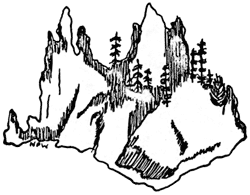
Floral Life Zone On The Phantom Ship
By William E. Bush, Ranger-Naturalist
Among the scenic attractions at Crater Lake, few excel in popular
appeal or give rise to greater exercise of creative imagination than the
small island known as the Phantom Ship. This rugged little island with
its spires of andesite, is generally considered to be no more than a
picturesque old rock, furnishing appealing subject for those who would
use it as vehicle for their contemplations in fantasy by way of mind,
palette, or film. Actually, time is fashioning a biological unit on the
island; the usual sequences and consequences of nature are molding
discernible, competitive boundaries and patterns of adaptation upon its
rugged surface.
Physically, the Phantom Ship is a remaining section of the filled
conduit of a fissure from which probably poured many of the lower layers
of lava constituting Dutton Cliff. Its rocks of pyroxene andesite have
in many places been altered by hydrothermal activity. Quartz filled
seems give the rock a character uncommon to most of the rocks generally
found on the crater walls. The island is about 500 feet long and reaches
a maximum width of 200 feet near the east end. Its east-west ridge of
spires, towering 170 feet above the water, sharply divides most of the
island into two slopes, one very steeply sloping to the south and the
other less steeply to the north. The island is separated from the
mainland by a shallow channel about 200 feet wide. Above this channel,
Dutton Cliff rises abruptly, constituting one of the highest sections of
the south-west wall of the caldera.
Observations noted herein were made during two visits to the island
on August 8 and August 19, 1946. Some hours were spent in perusal of the
situation as it existed, but the plant tally was made on the second
visit only. The listings are not to be considered as complete and
certainly it will be worthwhile to make additions and corrections as
subsequent observations suggest.
The accompanying sketch illustrates roughly the bio-geographic
layout of the island. The west end of the island is made up of tall
spires which rise vertically; a limited talus at the water's edge is all
that lies between the spires and the water. In this region, few plants
have gained a foothold and the area must be essentially classified as
barren.
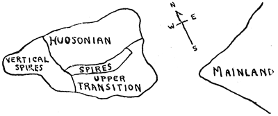
The remainder of the island is divided into two slopes which show a
definite segregation of species. White bark pine grows on both slopes in
nearly equal areal density, though it appears to be much more in its
element on the north side.
The South Slope - The south and southeast slopes of the
island, while undoubtedly subjected to great extremes of temperature,
are predominantly a warm section. Three ponderosa pine live a stinted
existence in this region. The largest one is 35 or 40 feet high and 56
inches in circumference, three feet above the root spread. On this slope
are four western white pines, the largest of which is 34 inches in
diameter; it is broken off 20 feet above the ground and a crown of new
growth doubles that height. High on the east end is a taller one 60 feet
high and 25 inches in diameter; it bears an old lightning scar, now
nearly healed. These trees are bearing a good crop of cones this year.
The ponderosa pine cones are smaller than normal.
A considerable coverage of green manzanita (A. patula) grows
just below the spiring ridge that separates the island into two parts;
it continues to the water's edge. All of this presents a clear cut
transition situation. However, in addition to this there is considerable
mat manzanita (A. nevadensis), and an intermixture of small
white-bark pines. In a few cases there may be confusion between P.
albicaulis and P. monticola, but most of the trees were
bearing cones and no mistake was possible.
The complete absence of lodgepole pine or alpine fir seems
surprising, but may probably be explained by the dearth of
water-stabilized soil or duff. It was also noted that not one specimen
of either red fir or hemlock was found on this slope.
The North Slope - The north slope is less steep than the
south; it presents some areas with a soil of erosional debris and duff.
On this slope are growing trees typical of the lower Hudsonian Zone.
Shasta red fir exist in considerable areal density, but are small for
the specie, while mountain hemlock grow in about the same stand density,
but the mature trees, though small, are apparently in good condition.
The white bark pine on this slope are normal and of good size. The total
number of trees (a foot or more high) is 66 while the south slope
supports only 28.
High, near the east end of the north slope, is one specimen of white
fir about 30 inches high. It appears to be in good condition and should
subsequently be checked for its existence and growth. It apparently is
the only one on the island.
At the foot of this slope there is a flat talus which is supporting
a number of herbaceous plants typical of shady, moist localities;
including shield fern, meadow rue, Jacob's ladder, and bleeding heart.
The distribution of herbaceous plants and shrubs is apparently
controlled by localized circumstances and zonal distribution is far from
obvious. The appended list of the plants observed gives their general
location.
Among the unlisted, but not unnoticed flora are the brilliantly
colored yellow, red, and orange lichens which cover the vertical walls
of the towering spires. Occasional single plants of grass are to be seen
near the water's edge. No attempt at identification of these was
made.
Animal life observed consisted of birds, obviously transient. There
were two Clark's crows and three Sparrow Hawks but no other birds were
observed. On the first visit, one golden mantled ground squirrel was
seen on the talus at the east end. None was seen on the second visit. No
traces of other animals were noted, but the writer does not profess to
be a skilled observer of such evidences.
Some evidence of human trespass were evident. Recent foot marks on
the upper level soils, a film carton, three paper plates, a paper
drinking cup, a rusty beer can, and several pieces of orange peel gave
evidence that human influence cannot be overlooked.
From 1910 to 1940, the level of the lake has been dropping; this
year the lake level is three feet higher than at comparable season in
1940. Evidence of this rise of level is to be noted in the fact that
several shrubs, probably willows, have been destroyed by the rising
water and their roots and stems are now a foot or more beneath the
surface. A half dozen such plant remains were observed.
Thus the island gives rise to two rather clearly defined life zones,
namely a hybrid sort of transition on the one side and a definite
Hudsonian on the other. A total of about 94 forest trees, including six
species, and 32 species of ground plants were observed to be growing on
the Phantom Ship.
The following forest trees large enough to be considered as firmly
established (a foot or more high) have been noted:
| Tree | Typical Zone | South Side |
North Side | Total No. |
| Pinus ponderosa Dougl. | Transition | 3 | 0 | 3 |
| Pinus monticola Dougl. | Upper Transition
to Canadian | 4 | 2 | 6 |
| Pinus albicaulis Englem. | Hudsonian | 21 | 29 | 50 |
| Abies concolor Lindl. | Transition | 0 | 1 | 1 |
| Abies magnifica shastensis Lemmon. | Canadian to
Hudsonian | 0 | 17 | 17 |
| Tsuga mertensiana (Bong.) Sargent. | Hudsonian | 0
| 17
| 17
|
| Totals |
| 28 | 66 | 94 |
| Ground Plants | Common Name | Occurrence |
| Filix fragilis (L) Gilib. | Brittle Fern | Few (2 or 3) seen. |
| Polystichum scopulim (D.C. Eaton) Maxon. | Shield Fern | Two on North side near water level. |
| Smilacina amplexicaulis glaber Macbride. | False Solomon | Common. |
| Salix lasiandra abramsii Ball. | Abrams Willow | One small plant on south side (8 feet). |
| Salix orestera Schneider | Sierra Willow | One plant on south side. |
| Thalictrum sparsiforum Turcz. | Meadow Rue | Common on north side near water level. |
| Actaea spicata arguta (Nutt.) Torr. | Baneberry | One plant on north side. |
| Dicentra formosa (Andr.) DC | Bleeding Heart | Common at lower levels. |
| Arabis (specie) | ---- | East end near water. |
| Ribes cereum Dougl. | Waxy Current | Common. |
| Ribes lacustre (Pors.) Poir. | Prickly Currant | Common. |
| Mitella breweri Gray. | ---- | Common on north side. |
| Holodiscus glabrascens (Greenman) Heller. | ---- | Common. |
| Sorbus cascadensis G. N. Jones | Mountain Ash | One plant on NE end. |
| Amalanchier florida Lindl. | Service Berry | Most common shrub. |
| Lupinus andersonii Watson. | Lupine | Occasional on SE end. |
| Epilobium glaberrimum Barbey. | Willow Herb | Common on north side. |
| Pyrola picta Smith. | White Veined Pyrola | One plant, north side. |
| Pyrola secunda L. | One-sided Pyrola | One plant, with P. picta |
| Arctostaphylos patula Greene. | Green Manzanita | Considerable on south side. |
| Arctostaphylos nevadensis Gray. | Mat Manzanita | Common on south side. |
| Polemonium shastense Eastwood. | Jacob's Ladder | Several plants in rock crevices on north side. |
| Phacelia heterophyla Pursh. | ---- | Common. |
| Penstemon menziesii davidsoni (Greene) Piper. | Pride of the Mountain | Common. |
| Penstemon rupicola Howell. | ---- | Common. |
| Castilleja miniata Dougl. | Paint Brush | Common. |
| Anaphalis margaritacea (L.) Benth and Hook. | Everlasting | Common on east side. |
| Taraxacum palustre vulgare (Lam.) Fernald. | Dandelion | Several near water's edge on east end. |
| Chrysothamnus nauseosus speciosus (Nutt.) Hall. | ---- | Common on east end. |
| Antennaria geyeri Gray. | ---- | Several on east and near water level. |
| Eupatorium occidentale Hook. | Western Boneset | Common. |
| Hieracium albiflorum Hook. | Hawkweed | A few on east end. |
- o -
Perception of Nature leads to Knowledge;
Knowledge, to Understanding, Interest, Love.
- o -
|