|
Volume XXIV - 1993
Drought and the 1992 Pond Survey
By Roger Brandt
Introduction
The summer of 1992 arrived with a combination of circumstances that
may earmark this season as having the most extreme drought conditions
ever recorded in the history of Crater Lake National Park. Two factors
were instrumental in making this happen. First, Crater Lake National
Park experienced a very dry winter and spring from December 1991 to May
1992, with snowfall for that period being 45 percent of the average
amount. This has a historic significance because it marks the lowest
accumulations of snowfall in the 60 year weather record of Crater Lake
National Park. Second, the summer of 1992 marks the sixth consecutive
year of drought in this region, though below average precipitation has
been the rule for all but three years in the past fifteen. Inasmuch as
the park's surface water resources were already under stress, the record
low snowfall of this winter and spring intensified the scenario.
Six Ponds That Survived the Drought
Twenty eight ponds are located inside the boundaries of Crater Lake
National Park, with most situated in the western half of the park. The
majority of these ponds have depths of two to four feet when filled with
water and have maximum diameters ranging from 30 to 200 feet. Spruce
Lake is the largest of the ponds, with a maximum depth of about 12 feet
end a length of over 300 feet. Several ponds in the Sphagnum Bog area
and on Whitehorse Bluff have maximum depths of six to eight inches and
diameters of 20 to 50 feet. All of the ponds appear to be filled only by
direct rain or snowfall rather than by surface water. Some subsurface
inflow is a possibility in a couple of ponds. The ability of these ponds
to sustain appreciable water levels through the dry summer seems to be
governed by the substrate that forms the basins where these ponds are
located. Ponds which are poised in depressions on the surface of lava
flows, like Quillwort Pond and Whitehorse Pond #3, for example, are the
most persistent, whereas ponds poised in pumice fields from Mount
Mazama's climactic eruption, like Spruce Lake and Lake West, are the
least persistent.
During the summer of 1992, it is likely that only six of the twenty
eight ponds in Crater Lake National Park did not dry up before the first
substantial storms came in mid October. These ponds are listed in the
table and can be found on the I :62,500 topographic map of the park
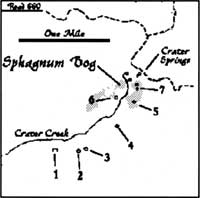
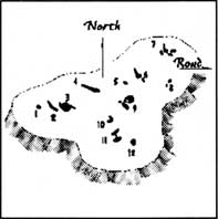
published by the U. S. Geological Survey. The figures delineate the
locations of ponds in the Sphagnum Bog and Whitehorse Bluff areas.
NAME/LOCATION
OF POND | DATE OF
SURVEY |
WATER
DEPTH | NOTES |
|---|
| Sphagnum Bog #2 | 9 Aug 1992 | 1 ft. |
May have received subsurface water from Sphagnum Bog Pond #3 |
| South of Castle Point | 25 Aug 1992 |
8-10 in. | Large salamander population |
| Whitehorse #2 | 2 Sept 1992 |
1 ft. | May be receiving subsurface water from Whitehorse Pond #3 |
| Whitehorse #3 | 2 Sept 1992 |
2+ ft. | Possibly the most robust pond in the park |
| Quillwort Pond | 24 Aug 1992 |
2 ft. | Water level was about the same when observed by others in mid-October |
| North of Pumice Flat | 10 Aug 1992 |
2+ ft. | Heavily used by elk |
Most persistent ponds of Crater Lake National Park.
(see maps for the numbering system used with ponds in the Sphagnum Bog
area and on the Whitehorse Bluff.)

Sphagnum Bog ponds
|

Whitehorse Bluff ponds
|
Lake Level Bottoms Out
By Thomas McDonough
The lowering in the surface level of Crater Lake recorded during the
last few years could be over. A return to a more average winter pattern
where snowfall amounts exceed 500 inches has already been realized in
1992-93. This snowpack, and any additional precipitation, should all but
stop the decline in lake level observed since 1986.
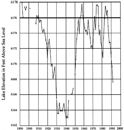
The rise and fall of Crater Lake's level this century is connected
closely to the fluctuations in the region's weather. Lake levels have
been observed and recorded since early this century. Crater Lake was at
its deepest in March of 1975 when the lake level measured 6179 feet
above mean sea level. This is 16 feet above its lowest point, which was
measured in early September of 1942. In 1959, when the U.S. Geological
Survey measured the depth of the lake and found it to be 1,932 feet
deep, the lake level was 6,176 feet above sea level. This is a good
indication that the lake level is always in flux.
Lake level is primarily affected by annual precipitation. For the
lake to retain the same level observed the year before, 66 inches of
precipitation must be recorded at Park Headquarters. This would come
largely as snow and approximates to roughly 530 inches of annual
snowfall. If more is received, the lake will be higher during the
following summer. If less is recorded, the lake level will fall. A
declining lake level has been the case for the last six years. Only 243
inches of snow fell from July 1, 1991 to June 30, 1992. In late
September of 1992, at the end of the water year, Crater Lake's level
fell below 6,169 feet. This is close to levels seen in the 1940s and
therefore represents a fifty year low. Crater Lake has, however, not
been alone among lakes in the region. Upper Klamath Lake and reservoirs
throughout southern Oregon also dropped to levels not seen for
decades.
If precipitation patterns observed earlier this century are used,
Crater Lake will require six years of greater than average snowfall to
regain the volume of water lost since 1986. It is likely that the lake
will take many more than six years to reach higher levels again.
Forecasting future weather patterns and associated lake levels is, at
best, risky. Nevertheless, we seem to be at the end of a dry cycle that
has been expressed by a drop in Crater Lake's surface level.
Crater Lake Surface Variation
September 30th

Observed elevation of the lake surface this century.
The surface elevation of 6,176 feet is 1,932 feet above the deepest part
of the lake. Gaps in the chart are due to periods when measurements
were not taken.
| 
