|
Volume XXVI - 1995
Fire as an Agent of Change
By Doug Lowthian
In 1994, Crater Lake National Park experienced 44 forest fires.
These fires occurred throughout the park, from the Boundary Springs area
to Sharp Peak and Annie Creek. Contrary to the widely held belief that
fire in the forest is devastating and destructive, the fires at Crater
Lake were beneficial products of a natural process eons old.
The vast majority of these fires during the 1994 fire season were
under one tenth of an acre. A few grew to an acre or two, but less than
five surpassed ten acres. One event, known as the Agee fire, was
particularly interesting. This fire took nearly a week to find as the
lookouts kept losing sight of the furtive smoke. Rugged topography south
of the lookouts at Watchman and Mount Scott prevented a clear
pinpointing of the smoke. It would pop up in the afternoon for a short
time and then disappear, laying down in the tree canopy. When the smoke
could be seen, it seemed to be on the southwest flank of Crater
Peak.
A team of two firefighters were sent to locate the source of the
elusive smoke. After four hours of climbing up and down the steep
slopes, pushing through thick stands of snowbrush, Ceanothus
velutinus, and sliding down scree, they stopped for lunch. In
casually scanning the northern skyline, they saw something that made the
drop their sandwiches and pick up their binoculars. They found the
smoke, but it was not on Crater Peak. Although in line with the lookout
tower on Watchman, the fire was on a ridge above the East Fork Annie
Creek--over a mile and a half away! Since a deep canyon lay between them
and the fire, they ate while hiking out. This turned into a near run so
that they could get back to East Rim Drive and revealed itself, less
than one and a half mile from headquarters. In an ironic twist, this
fire turned out to be one of the closest to home.
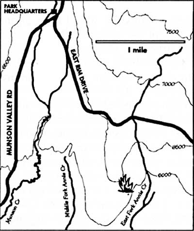
Locating this fire on the park map is easy. Place your finger at
Park Headquarters and follow East Rim Drive until it crosses the east
fork of Annie Creek. Turn south and go about three quarters of a mile.
On the west side of the creek, a steep slope runs up from the canyon
bottom to the 6,000 foot level. You will see a ridge dividing the middle
and east forks of Annie Creek. Along this ridge the fire burned slow but
steady through a mature forest consisting of Mountain hemlock. Tsuga
mertensiana, and Shasta red fir Abies magnifica-procera. Upon
discovery, the fire covered less than half an acre. The decomposing
layer of needles and twigs smoldered and smoked heavily. Occasionally
the crackling of burning live needles broke the quiet. Small seedlings,
with their branches near the ground, were torching. This sent flames up
as high as three or four feet, dying out as quick as they started.

Map by Susan Marvin.
There have been fires around what is now Crater Lake National Park
for many thousands of years. Chances are, however, that what became
known as the Agee Fire was the first in this part of the forest for
quite some time. Far from being static and seniscent, the forest is
constantly changing. Agents of change such as wind, precipitation, and
fire alter species composition and stand density in the forest. These
processes occur with varying frequency, depending on the type of forest.
The frequency of fire in a given locale can be averaged to obtain its
Fire Return Interval. This number can vary greatly throughout a forested
area depending on the species makeup, altitude, aspect, topography, and
prevailing weather patterns.
The forest where the Agee fire burned has a mean fire return
interval of approximately 40 to 50 years. This means that the fire was
burning on land that probably had not burned in the last 50 years or
more. The variability among fire return intervals is usually very broad.
For example, one researcher may find evidence of fires within the last
decade, while another might find that a similar area had not burned for
120 years. The accuracy of these numbers usually depends on the extent
of the survey.
The Agee fire burned for about eight weeks before being extinguished
by snowfall in early November. During this time, firefighters made
efforts to contain the fire within a fixed perimeter. With many other
fires burning throughout the park at the same time, people and equipment
were stretched thin. The weather remained hot and dry for several weeks
after the fire started. Temperatures in the 80's and humidity as low as
13 percent pointed to conditions normally associated with high fire
danger. For the most part, however, the fire burned slowly through the
underbrush and duff layer.
To study the effects this fire would have on the forest, plots were
established in the path of the spreading flames to measure various
components of the stand structure. These plots quantified the amount of
burnable material, or fuel, and the quantity and density of live trees
and shrubs. By reading the plots before and after the fire the change
caused by the fire could be measured.
The results of these measurements point to the fact that fire is
rarely a devastating event. Even the massive fires at Yellowstone in
1988 were agents of change that led to massive regeneration of the
forest. The Agee fire, burning through a period of high fire danger,
altered the forest in ways that were not as dramatic as all-consuming
fire storms. This fire killed just 13 percent of the trees over ten feet
tall, and only 41 percent of the trees under ten feet tall. The fire
thinned out the young trees, providing better conditions for the growth
of those that remained. What few large trees that were killed now allow
for more sunlight to reach the forest floor where grasses and shrubs
will sprout next year. During the fire many signs of elk were present an
should be again once the forage returns. The large dead trees will also
provide valuable habitat for birds, bats and insects. In topping out at
30 acres, the Agee fire left a forest changed but far from
devastated.
Another change documented at the Agee fire involved deduction of the
fuel load. This is composed of dead and down sticks and logs, as well as
duff and needles. From a pre-burn level of 17.96 tons per acre, the fire
consumed 14.53 tons per acre of fuel. This 81 percent reduction
accomplished several things. Stored nutrients were released, making them
available for future plant growth. In addition, such reduction can
prevent the unnatural build up of fuels (which can lead to high
intensity fires) that results from overzealous suppression of all
fires.
Suppression of all fire at Crater Lake National Park was practiced
for roughly 75 years. During that time much natural change in the forest
has been stymied. When the snow began to fall in early November, there
was still heat in the Agee Fire. By this time the fire crews were long
gone and the fire cache was closed for the year. Snow fell gently and
the temperature hovered around 30 degrees. Standing in the midst of the
burn, I warmed my hands over embers in a slowly burning log. I thought
about the regrowth, elk, and more fires in the summer of 1995.
Further Information
James K. Agee, Fire Ecology of the Pacific Northwest Forests.
Washington, D.C.: Island Press, 1993.
C.B. Chappell, Fire Ecology and Seedling Establishment in Shasta
Red Fir Forests of Crater Lake National Park. M.S. thesis,
University of Washington, Seattle, 1991.
Doug Lowthian is a seasonal firefighter at Crater Lake
National Park.

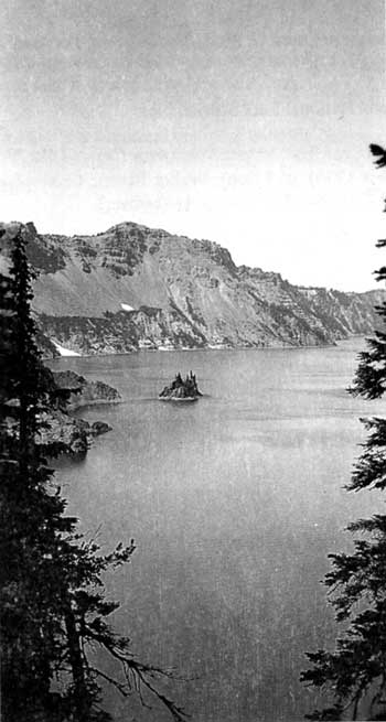
Phantom Ship from Kerr Notch in 1936. Homer Marion
photo, NPS files.
|

