|
Volume XXVIII - 1997
Visited in Midwinter: A Trip to Crater Lake in 18971
By M. A. Loosley
Editor's note: The following article represents
the first recorded account of a winter visit to Crater Lake. It appeared
in a Klamath Falls newspaper 100 years ago.
We left Fort Klamath on Tuesday, February 23, at 2:30 p.m. mounted
on showshoes and drawing a hand-sled on which we packed our provisions
and blankets and went that afternoon as far as Chas. Martin's place at
the upper end of the valley.2 That night the mercury went
down to four above zero which made snowshoeing fine the next day, until
we got within four miles of Bridge Creek, where the thermometer stood 45
degrees in the shade and 83 degrees in the sun, which temperature
softened the snow to such an extent that it made shoeing
impossible.3 We then ate our noonday lunch, put our shoes on
the sled and footed it through the soft snow above our knees to Bridge
Creek, where we arrived at 6 o'clock that evening, all tired out, having
made only four miles that afternoon. After eating supper we made our bed
down, or rather up, on fourteen feet of snow. Of course this was only a
drift, as we did not have time that evening to look around for a
shallower snow-bank upon which to make our bed.
Next morning we arose at daybreak, made breakfast and took the depth
of the snow on the ledge across the creek, which we found to be only 8
and one-half feet deep. The thermometer registered that morning 28
above.4
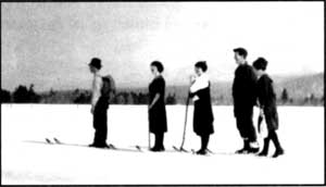
Skiers going to Crater Lake from Fort Klamath in
1918. Photo by Alex Sparrow.
|
Again we mounted our shoes and shoved our way slowly up Annie Creek
Canyon, arriving at Cold Camp at 11:30 a.m., where we lunched and
rested.5 We found the snow to be only 8 feet deep there. We
had to abandon our shoes going up the summit and "take it afoot," as the
mountain was so steep that our shoes would slip back. However, we
arrived on top at 1:20 p.m., and found the snow there to be 10 feet
deep.6
When we got on the summit, instead of keeping [to] the road leading
down on the other (north) side, we turned to the right and went along
the backbone of the mountain which we thought would be a gradual slope
all the way up to the lake and would avoid footing it down the mountain
and crossing the swale and up the steep mountain again on the other side
to the lake.7 But two miles of extremely difficult traveling
along the steep backbone, through snow up to our waists, brought us to
the conclusion that we had better abandon our roundabout trip and make
our way down the mountain side to the camping place at the foot of
Crater Lake Mountain, which we did, arriving in camp at 5:25 p.m. It
would be useless to say that we were wet through to the waist and all
tired out. However, we lost no time in getting a few slabs of thick fir
bark upon which to build our fire by which we dried our clothing and
cooked our supper.
Next morning, being the 26th, we left camp at 6 o'clock without
breakfast, for the lake. Two miles up the steep mountain brought us to
the brink of the most picturesque view which we were privileged to
behold. There was the lake away down in the almost bottomless pit
wrapped in the snowy gause of silence, while the gentle rays of the
rising sun kissed the snowcapped peaks of the surrounding mountains as
the gentle breeze rippled the inky water far below. There was a soft
breeze blowing from the south, while the mercury stood at 38 in the
shade and 76 in the sun.
There was a thick skim of ice on the west end of the lake extending
eastward from the bank some two hundred yards and probably half a mile
long north and south.
The snow under the trees on Mrs. Victor's rock was five feet deep,
while back farther in the open it was 10 feet, and seemed to be of an
even depth all around the south side.8 It was impossible to
go down to the water as the snow which had blown from the south, broke
off abruptly from the top for probably one hundred feet below when it
would take its regular slant until within about the same distance from
the water where it would again form another perpendicular bank. The
water seemed to be as black as ink. We had a very strong glass with us,
but we could not see any beach at the water's edge.
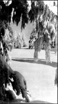
Photo by Rudy Lueck, 1935.
|
The snow was all off the trees on Wizard Island and surrounding
bank, while the strip of land running out northwest from the island
seemed to be a floating snowdrift.
We spent about an hour and a half at the lake when we turned our
shoes homeward, where we arrived on the evening of the 27th.
No pen can describe the picturesque views we beheld on our trip. No
orator could do justice to the mountain breeze, the crisp mild air and
delightfully cool water bursting gleefully from the sides of the
mountains. Now we are passing along one of nature's wonderful creations
-- a canyon -- where massive perpendicular rocks rise hundreds of feet
on either hand. Again in open space, with massive peaks all about us, do
we find ourselves. These nearest spurs are snow-capped and uninviting;
those at a distance jagged and rugged.
The scenery at times partakes of weird and grotesque appearance, and
is then grand and awful. Odd forms of snow, sometimes resembling mammoth
animals, overhang our path or project from the mountain beyond and
appear ready to leap upon us. Over all this magnificence, enhancing the
picture to a marvelous degree, shone the azure vault above.
It is true we found places that were extremely difficult of
traveling over, and yet how foolish we would have been to remain at home
because of them. Deep gulches must be crossed, narrow and sliding ones
were not infrequent. More than once did we hold our breath as we passed
over some of these places, but a steady nerve and lots of energy were
all that was necessary to carry us through.
Notes
1 Originally titled Visited in Midwinter: A Trip to Crater
Lake Through Unfrozen Snow -- A Difficult But Interesting Adventure. It
was originally written as a letter to Captain O.C. Applegate and
subsequently published as a newspaper article in March 1897.
2 The author was in the company of his brother, P. S.
Loosley. Martin's homestead was about 1.5 miles north of the town of
Fort Klamath near what is presently Highway 62. The brothers would have
gone approximately five miles that afternoon since the Loosley Ranch is
located south of town.
3 This area is where the ponderosa pine and white fir
forest gives way to lodgepole pine, a transition readily seen along the
south entrance road. Bridge Creek is now called Pole Bridge Creek.
4 Much of the temperature difference between the two days
was due to the downslope movement of air. This often makes the area
around Fort Klamath (at 4200 feet in elevation) much colder than a site
on Mount Mazama such as Pole Bridge Creek, some 1600 feet higher.
5 The vicinity of Annie Spring.
6 Their route corresponds to the trail which connects
Annie Spring with the Pacific Crest Trail.
7 They tried traversing Munson Ridge instead of using the
wagon route which roughly corresponds to what is now the Dutton Creek
Trail.
8 Victor Rock is where the Sinnott Memorial is presently
situated. The south side described by Loosley was named Rim Village in
1924.
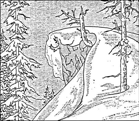
Winter Illustration by L. Howard Crawford, Nature
Notes from Crater Lake, 8:1, July 1935.
|