|
|
|
GRAND TETON NATURE NOTES
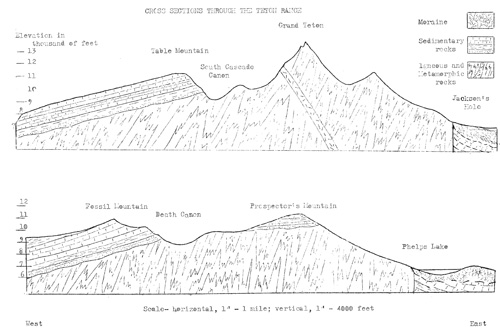
THE GEOLOGICAL HISTORY OF THE TETON RANGE, A SUMMARY by Howard R. Stagner How were the Tetons formed? Why does this mountain range have such an abrupt, precipitous eastern front? How were the deep, cliff-bound canons formed? what is the explanation of the conspicuous black dike that appears on the eastern slopes of Mount Moran? These are but a few of the many questions that thrust themselves before the attention of the visitor to Grand Teton National Park. An understanding and the full appreciation of these wonders of Nature demands a knowledge of the events that have occurred in this area during the geologic past. The limited size of Nature Notes precludes the telling of the geological story in one or in a number of issues. In order to treat the story in the detail necessary to give a true conception of the geological story of the range it will be necessary to relate each phase of the story and each episodes eparately in different issues of this bulletin. An attempt shall be made to make each episode complete in itself, but each will form a part of a series that will tell the story of the geology of the Tetons as far as it is now known. With this purpose in mind, an effort has been made in tho following account to summarize and to date the major events of Teton geological history. The reader of future articles can, perhaps, by reference to the following, better understand the more detailed descriptions in their relation to the complete story. I. An Ancient Landscape Looking backward in geologic time, the duration of which is as impossible of human conception as is the extent of astronomic space, one can see but the most indistinct suggestions of the beginnings of the earth and of its earliest history. Many events certainly took place- volcanic eruptions, earth movements, atmospheric and climatic changes, the beginnings of life- events of which the rocks bear very little record that can be recognized and interpreted. After assigning these vague things to the unknown geologic past, we come to a time when it is known that no mountains such as are now so prominent in the Rocky Mountain region, existed. In place of high mountains and mountain-girt basins, western United States was a low subdued land, presenting a landscape of low hills, shallow valleys and gently rolling plains. The relief was low and the average elevation was but little above sea level. The most ancient of rocks composed this land. These were chiefly the metamorphic rocks gneiss and schist into which granites, pegmatites, diorites and other igneous rocks had been intruded. II The Ancient Sea- At the time when our known geological story begins, this ancient land was subsiding along broad, elongated areas to permit the waters of the oceans to flood these portions of the continent. At various times such continental seas extended from Lower California northward and northeastward across western United States to connect with similar seas coming from the Arctic regions. Other invasions of the seas began in the Gulf of Mexico area and connected across the Rocky Mountain area with the Arctic seas. Many times the seas advanced and retreated over the Rocky Mountain region, and many times the Grand Teton area and surrounding areas were alternately covered by the seas and exposed as dry land. Rivers, flowing from neighboring highlands, brought millions of tons of sand, silt and limy ooze into the seas and millions of plants and animals of the seas, upon dying, left their calcareous hard parts to add to the material accumulating on the sea floor. All of this material was distributed in nearly horizontal layers on the floor of the sea. During the time since then, pressure and natural cements have hardened these deposits to form the sedimentary rocks sandstone, shale and limestone. The total thickness of sedimentary rocks in the Grand Teton region is in excess of 6,000 feet. Occasionally plants and animals which inhabited the seas or the land were buried with the sediments in such a manner that they were preserved in the rocks as fossils. III. The Building of the Mountain Highlands Finally the continent emerged permanently from the seas, and soon "wrinkles" or upward folds began to appear in the rocks as the continent was squeezed by tremendous forces. These folds grew to form the highland areas that are now the mountain ranges of the Rocky Mountain region. In the Teton area such an upward fold, about fifty miles long north to south, and fifteen miles wide, fractured along its eastern side to form a great fault. The total upward movement of the Teton Range along this fault was at least 7,000 feet, and may have been as much as 12,000 to 14,000 feet. The displacement was not the result of a single catastrophic movement, but was doubtlessly attained as the result of innumerable small movements occurring over a long period of geologic time. While the mountain area was rising, great volcanic outpourings and eruptions developed in the areas to the west, north and east of the Tetons. Some of the breccia and ash from the Yellowstone explosive volcanoes were without doubt carried into Jackson's Hole. Great rhyrlite lava flows from Yellowstone submerged the north end of the Tetons, and thegreat basalt lavas of Idaho flowed against the western slopes of the range. However, very little if any evidence of actual outpourings of lava or of eruptions of breccia and ash have been found in Jackson's Hole or in the Teton Range. IV. The Sculpturing of the Tetons Immediately after the uplift of the mountains, or more truly, while this process was going on, running water and moving ice began to carve canons into the uplifted fault block. Running water has continued to be very active in the erosion of the mountains and in the removal of much sedimentary, igneous, and metamorphic rock material from the mountains area. Periodically glaciers formed in the mountains and moved down the steep slopes to deepen and to render more rugged the existing canons. Three times did glaciers form, enlarge, and move down the canons onto the floor of Jackson's Hole. V. The Tetons Today The Teton Range is now in a post-glacial period, and the great glaciers have long since melted hack until they are confined to the cirques at the heads of the canons. Seven such small glaciers and numerous permanent ice fields still exist- remnants of the once great alpine glaciers. So, streams and glaciers have combined forces to carve from an uplifted fault block the present rugged Teton Range The deep, steep-sided, "U"-shaped canons and the deep, cliff-bound amphitheatre-like cirques at their heads; the sharp, saw-toothed ridges and the "horn" peaks; the cascades, falls and numerous lakes all owe their origin to the mighty glaciers of the past. Erosion by streams and glaciers has removed from the high portion of the range its former covering of sedimentary rocks. So, again, the ancient rocks are exposed to form the high Teton peaks. Only on the western side of the range, and in its lower areas to the north and to the south of the culminating peaks do the sedimentary rocks still remain. We know not what lies ahead. Erosion is still going on at a rapid rate, and in neighboring areas the tremors of earth movements are still felt. Thus, the endless war between the forces of building and the agents of destruction continues. Nature is never idle, and "time, which means everything to our idea, and is often dificient to our schemes, is to Nature endless and as nothing". --------------- Chronology
| |||||||||||||||||||||||||
| <<< Previous | > Cover < | Next >>> |
vol2-4a.htm
14-Oct-2011