|
|
|
GRAND TETON NATURE NOTES
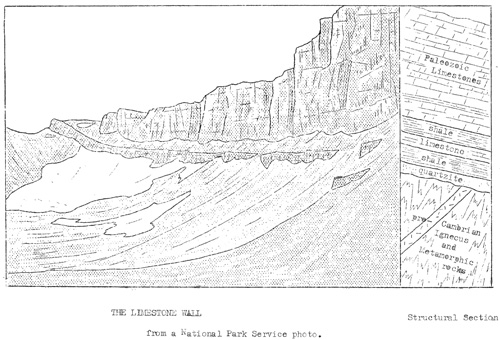
ACTIVITY AT THE LIMESTONE WALL by Howard R. Stagner During the past summer and fall a great column of rock became detached from the Limestone Wall, and in settling, resulted in the destruction of a portion of the Skyline Trail which passes in front of it. It is not unusual for large masses of rock to become dislodged from cliffs and steep canon walls and to fall to the depths below. In this particular case, however, the movement and the resulting destruction of the trail were accomplished in a more indirect manner, and the event is considered worthy of recording in Nature Notes. The Limestone Wall encircles the broad head of Avalanche Canon, and forms the west boundary of Grand Teton National Park. It lies above timberline at an elevation of about 10,500 feet above sea level. A narrow ledge about half way up the eastern exposed face of the wall was followed in locating the Skyline Trail where it crosses Avalanche Canon. Below this shelf steep talus slopes form a continuous grade downward to the canon floor, interrupted here and there by exposed ledges of limestone. Above the trail massive beds of limestone rise in vertical columns and walls to a height of several hundred feet. The wall itself is formed of the exposed edges of several Paleozoic limestone formations. These dip toward the west at an angle of about 10 degrees, and rest on a series of Cambrian formations consisting, from the base upward, of a quartzite, a shale, a limestone and a second shale bed. The limestone formations of the wall are massively bedded, but as a structural feature the stratification is much less prominent on the face of the wall than are vertical cracks opened by weathering along two sets of joints. The joints run through the limestone formations in two directions at right angles to each other and to the stratification. It is the normal thing for huge blocks of rock formed into parallelograms along the joints and bedding planes, or for great columns of rock bounded by vertical joints to become separated slowly from the wall and to plunge into the bottom of the canon. Eight such columns are now in the process of formation. One of those columns, some 150 feet high, 100 feet wide at the base, and 30-40 feet thick, provided an interesting variation to the normal process. The first indication that something was happening along the wall came when a part of the Skyline Trail caved away and large cracks developed between the trail and the loosened cloumn. The cracks were at least ten feet deep, and much loose rock and soil disappeared into them without accomplishing any apparent filling. At first it was believed that the base of the column was slowly swinging outward from the trail and was thus pushing directly against the trail and in this manner destroying it. That the column was actually pushing outward was apparent from observations and measurements made along its base, but that this was not the entire explanation was suggested by the large cracks between the moving column and the trail itself. How could the column be pushing the trail away when not only was the column not in contact with the trail, but in fact was separated from it by a ten inch crack?
Considerable speculation by Engineer McLellan of the National Park Service and the writer resulted in the development of two possible explanations. The first required that a considerable portion of the base of the column be buried by talus. In this case, with the top of the column resting against the wall with no outward movement taking place, then the pivotal outward swing of the base would push most against the deeper portion of the talus. The overlying talus would, of course, be carried outward an equal distance as it rode upon the deeper talus, but the higher part of the column, being closer to the pivotal point, would move outward through a shorter distance to leave the observed cracks between it and the surface of the talus. The second explanation also involved a carrying of the trail outward by the deeper moving material rather than a direct pushing action of the column on the trail. In this explanation it is believed that as the heavy column settled into the underlying shale, this soft material moved out from beneath the column in the only unconfined direction- outward away from the wall and away from the moving column, and as it "flowed" outward carried with it the talus on which the trail was located. The cracks developed as the the talus was carried outward away from the column by the deeper shale. In both cases the outward movement was sufficient to to dislodge the outer part of the trail which fell to the lower talus slopes. The fact that a large snowfield remained on this portion of the trail and along the base of the wall throughout most of the summer, providing, as it melted, a constant supply of water to saturate and lubricate the shale, is probably of some significance. Although shale is known to flow under great earth pressure- geologists frequently encounter examples of such flowage in the limbs of folds- probably such a movement would not be possible at the surface of the earth and under such moderate pressures unless the shale were so saturated and lubricated. There is evidence to support each of these two theories. An examination of the relative positions of the limestone, shale and talus along other parts of the wall indicated that not a large portion of the base of the column is buried by talus- not enough to alone account for the cracks as the first explanation requires. In support of this explanation, however, the outward movement of the column was several inches in excess of the downward settling. It is probable that both these processes acting together produced the effects described. At the time of the last visit to the wall, October 17, the column had settled from 4 to 10 inches, had moved outward about 14 inches at the base, and had pivoted to the south from 4 to 6 inches. It was believed at that time that the column could not long stand, but on November 1,the wall was viewed through binoculars from a vantage point on the east side of the Snake river in Jackson's Hole, and the column was still standing. Immediately below the column, however, fresh snow that had fallen a few days earlier, was covered with rock debris apparently loosened by new movements of the column. Future developments will be followed with considerable interest. | |||||||||
| <<< Previous | > Cover < | Next >>> |
vol2-4b.htm
14-Oct-2011