|
|
|
GRAND TETON NATURE NOTES
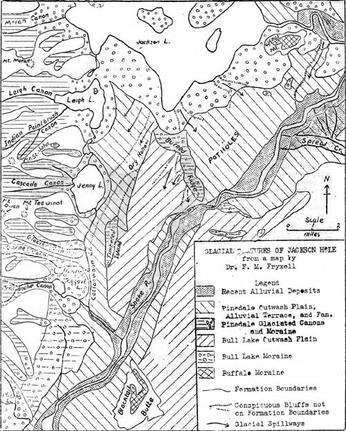
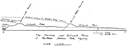
TETON GEOLOGICAL NOTES - No. 1 by Dr. F. M. Fryxell The geological record from which one may decipher the glacial history of the Teton Range is found in part within the mountains themselves, in part outside them, especially in adjacent Jackson Hole. To many visitors, speeding up the state highway, the flats of Jackson Hole may seem to offer little that is worth a second glance. But the geologist will recognize on the valley floor a great diversity of ridges, terraces, channels, and depressions, features that furnish the key to the glacial events which have occurred both in the valley and in the great range to the west. To grasp the significance of these features one can do no better than visit the east tip of the main section of Burned Ridge (see map, page 3), and from this point, with the Narrows of the Snake River directly below, survey the country to the north and south.
Here one sees that Jackson Hole is diagonally crossed by two low, wooded ridges: Burned Ridge on which we stand, and another ridge several miles to the north, that follows the south border of Jackson Lake. Around this northerly ridge the Snake River makes a circuitous eastward journey whence it turns southwestward and directly through Burned Ridge to form the Narrows at our feet. Were we to examine more closely, we would discover that both of these ridges are irregular and hummocky of surface, and composed of cobbles and boulders many of which are striated — proof that they were transported by glaciers, and that therefore the ridges themselves are typical glacial moraines. Equally distinct from our viewpoint are two broad plains which extend outward from these ridges and slope evenly southward. Unlike the ridges from which they emerge, these plains are overgrown with sagebrush; hence the moraines and the glacial outwash plains — for such they are — are strikingly distinct. Composed of porous quartzite gravel with little or no soil they constitute barren ground indeed for anything but sage. Both of the outwash plains are deeply trenched by the Snake River, and the northerly plain is continued south of the Narrows by terraces that border the Snake River well beyond Blacktail Butte, where they widen into the swampy flats of the southern part of Jackson Hole. The meaning of these features now becomes evident, for they can mean only this: that northern Jackson Hole was at two distinct times invaded by a glacier. These two times of glaciation must correspond to those which geologists have reported from the Wind River Mountains and elsewhere, on the basis of similar records there found. For the earlier of these times the term "Bull Lake Stage" is generally used; for the latter, "Pinedale Stage". In terms of these stages then, one may briefly review the glacial events of this region: In the Bull Lake Stage a glacier (The Burned Ridge Glacier) entered the valley from the north and northwest, and advanced as far as Burned Ridge. At this position it must have stood for a time long enough to permit the ice to heap up the Burned Ridge moraine, and the glacial streams to deposit the outwash plain extending southward from it. The plain must have reached unbrokenly around and beyond Blacktail Butte, into the most southerly reaches of Jackson Hole. In time the Burned Ridge Glacier melted back from its moraine, and eventually disappeared altogether. Did a large lake come into existence in the basin behind Burned Ridge? If so (as seems probable) it must have been drained during the interglacial stage which followed — an interval of long duration in the course of which streams greatly reduced the extent of Burned Ridge, trenched the outwash plain between the Narrows and Blacktail Butte, and in southern Jackson Hole largely eroded away similar Bull Lake deposits. The task of the streams was arrested unfinished, when in Pinedale time glacial conditions returned. Again a glacier (the "Jackson Lake Glacier") pushed into the north end of the valley, fed chiefly by smaller glaciers which occupied the Teton canons. In its southward growth it advanced over the same path as its predecessor of the Bull Lake Stage. The moraine of this glacier indicates that its front must have shifted back and forth. The large size of the Jackson Lake moraine is evidence of a prolonged stand in this position, but there are "islands" of moraine farther south, protruding from the outwash plain. That the ice front got farther south than even these "islands" is indicated by the pitted areas (locally called "the potholes") which lie between them and Burned Ridge. Presumably these pits mark situations where the glacier, in retreating, left behind it masses of stagnant ice which had separated from its main body. These ice masses became surrounded or buried by outwash gravels, which, when the ice later melted out, slumped in to produce depressions in the otherwise even outwash plain. Since pits of this sort extend all the way to Burned Ridge, one is led to conclude that the Jackson Lake Glacier for at least a brief time reached as far south as this ridge, that is, it practically attained the same limits as did the Burned Ridge Glacier long before. From this shifting ice front vast quantities of outwash gravel were carried out by short-lived glacial streams. These were deposited not only on the main outwash plain but within the river trench south of the Narrows and on the valley floor in southern Jackson Hole. Jackson Lake came into existence as the glacier retreated from the Jackson Lake Moraine, and the water was dammed between the moraine and the ice front. With the complete disappearance of the ice the lake assumed essentially its present size and shape. What of the Tetons during the two glacial stages? Here, as one might expect occurred similar events. Valley glaciers descended the canons and pushed out into Jackson Hole. The moraines left by the Bull Lake glaciers are now in most places eroded away, but Timbered Island and the high bench extending along the mountain front southward from Taggart Lake appear to be extensive remnants of Bull Lake moraine. The Pinedale moraines, in marked contrast, are beautifully preserved, and form the basins which are responsible for the existence of Phelps, Taggart, Bradley, Jenny and Leigh Lakes. But the glacial story can be pushed back yet another chapter. For evidence of this one must climb to the summits of Signal Mountain, Blacktail Butte, or one of the Gros Ventre Buttes. In these surprising situations one again discovers striated boulders and cobbles — mere patches of ancient moraine, like tattered manuscripts. Similar deposits occur on the highlands east of Jackson Hole, capping the intercanyon divides 1000 feet or more above the valley floor. The presence of morainal remnants in such situations, and their absence in the adjacent canyons, can be accounted for only by the assumption that there was a third glaciation which occurred much earlier than even the Bull Lake Stage, at a remote time when the floor of Jackson Hole was 1000 feet higher than now, and the present system of canyons which open into Jackson Hole had not yet been cut. This stage, which likewise has been recognized far outside Jackson Hole, has been named the "Buffalo Stage". Scanty as its record is we cannot doubt that this, the earliest of the three glaciations, was much the most widespread. Thus, what we commonly call the "Ice Age" or "Glacial Period" (the "Pleistocene Period" in geological terminology), which lasted perhaps two million years, really involved no less than three distinct times of glaciation, and two of deglaciation. These may be tabularly represented as follows: Postglacial time
Preglacial time The three glaciations were successively less extensive, and the later of the two interglacial stages was of briefer duration than the earlier. What of postglacial time, which represents the briefest interval of all? Is it truly postglacial, or are we now living in a third interglacial stage? To this question geology has as yet no positive answer, though investigation now in progress leads one to hope that a future solution is not improbable.
| ||||||||||||||||||||
| <<< Previous | > Cover < | Next >>> |
vol3-1a.htm
14-Oct-2011