|
|
|
GRAND TETON NATURE NOTES
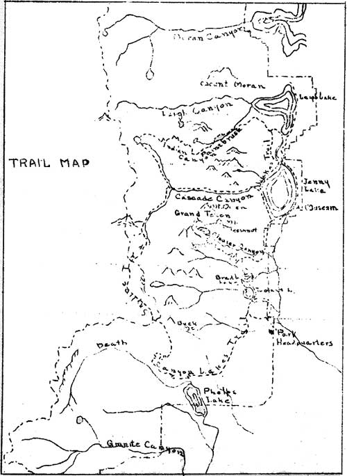
TRAILS IN GRAND TETON NATIONAL PARK by It is felt appropriate at this time to devote a portion of the current issue of Nature Notes to a brief discussion of the hiking and saddle horse trails in Grand Teton National Park. The construction of the Alaska Basin trail last year has brought about completion of the major part of our trail building program. It is by the use of these trails that access is made into the more remote areas of the park. The trail system makes available all characteristic sections of the park and at the same time leaves large areas of untouched wilderness. We can divide our trail system into four groups: The Lakes Trail, the Canyon Trails, the Skyline Trail and the Glacier Trail. We will discuss each group in order.
The Lakes Trail The Lakes Trail runs parallel to the Teton Range closely following the base of the mountains and skirts the shore of each large lake from Leigh Lake on the north to Phelps Lake on the south. It is the trail by which all the other trails are reached and is the one from which all expeditions into the mountains or canyons begin. No other trail within the park offers so many opportunities for wildlife study as does the Lakes Trail. The larger animals frequent the terrain which this trail makes available. The outlet of Leigh Lake, the marshy ground at the foot of Mt. Teewinot, the Grand Teton and Nez Perce Peak, the country near the Whitegrass Ranch and the Phelps Lake area are all fine feeding grounds for Shiras moose (Alces americana shirasi). Travelers along the trail, particularly in the early morning and evening, are seldom disappointed in obtaining glimpses of this large ungainly creature. The graceful blacktailed deer (Odocoileus hemionus macrotis) inhabits the forests and grassy meadows along the trail. Occasionally the American wapiti or elk (Cervus canadensis) can be seen at the mouth of the canyons but this animal is not often found in the park during the summer. Early and late in the season the black bear (Euarctos americanus cinomomum) may be observed from this trail. The only remaining antelope (Antilocapra americana americana americana) in Jackson Hole may be seen at the Whitegrass Ranch on a short detour from the trail. A good representative cross section of the smaller animals can also be seen from the Lakes Trail. Perhaps the most interesting being the beaver (Castor canadensis). There are numerous localities along the trail where the beavers are active, notably just west of park headquarters, Leigh Lake and Bear Paw Lake to the north of Leigh Lake. The marmot or rockchuck (Marmota flaviventris nosophora) is common along this trail. Occasionally the rare black variety is seen, although this unique Teton melanistic specimen is more often encountered at higher elevations. Both the golden-mantled ground squirrel (Callospermophilus lateralis cinerascens) and the Uinta ground squirrel (Citellus armatus) are met. The pine squirrel (Sciurus hudsonicus ventorum) and the chipmunk (Eutamias) are frequently seen. More rarely observed in rock slides along the trail is the curious little cony or pika (Ochotona princeps ventorum). The yellow-haired porcupine (Erethizon epaxanthum epaxanthum) is fairly common. The snow shoe rabbit (Lopus bairdii bairdii) is also frequently soon. More of the park's hundred species of birds can be seen in the area traversed by this trail than in any other section of the park. Space does not permit enumeration of the species that may be seen. The flora along the Lakes Trail is that characteristic of the piedmont area of the park. The forests are predominately lodgepole pine (Pinus contorta) and alpine fir (Abies lasiocarpa). Along the streams and lakes the Engelmann spruce (Picea engelmanni) is found. The stately Douglas fir (Pseudotsuga taxifolia) is occasionally seen. A varying wildflower exhibit is seen along the trail. The forested zones, the grassy meadows and the open flats each have their characteristic brilliantly hued display changing with the season but always bright and appealing. The traveler along this trail has ample opportunity to observe the geology of the mountain slopes and adjacent areas. He can study the pre-Cambrian crystalline rocks that make up the eastern mass of the Tetons. The trail crosses the glacial moraines in front of all the canyons from Indian Paintbrush on the north to Death Canyon on the south. In several localities the trail drops to the sagebrush covered outwash plains of Jackson Hole. At the southern end of the trail one notices the sedimentary rocks that begin to overlap the crystalline rocks of the mountains in this area. The Canyon Trails Only three of the intermountain canyons of Grand Teton National Park have been penetrated by trails. The remaining canyons have been left as truly wilderness areas and help preserve this park as a primitive one. The three canyons in which trail construction has been carried on are all quite distinctive and give the visitor an outline of the entire park area. The canyons reached by trail are Indian Paintbrush Canyon, Cascade Canyon and Death Canyon. Indian Paintbrush Canyon - The trail up this canyon leaves the Lakes Trail in the moraine built up by the glacier that once flowed down Indian Paintbrush Canyon. As the morainic material is left behind and the hiker or rider reaches the canyon proper, he passes through a beautiful stand of Engelmann spruce and then enters more open country filled with wildlife and a profusion of wildflowers among them the colorful paintbrush (Castilleja) for which the canyon is named. The trip up the canyon is one filled with evidences of past glaciation. Smoothed and polished rock is noted, glacial "benched" are seen, high on the canyon walls are hanging valleys, small ridges of morainic material appear and several abandoned cirques such as Holly Lake can be made out, until finally the summit plateau is reached. The summit plateau lying between Paintbrush and Cascade Canyons is of particular interest as it is in such contract to the glacially sculptured jagged peaks and ridges of the Tetons. Is this the re-exposure of the ancient pre-Cambrian land surface or the remnants of a later peneplaination? The trail crosses this intriguing plateau and crosses the divide between Cascade and Leigh Canyons and thence down a long slope into North Cascade Canyon, Lake Solitude and the Skyline Trail. Cascade Canyon - By far the most popular trail in the park is the lower portion of the Cascade Canyon Trail which leaves Jenny Lake and climbs above Hidden Falls. Throughout this area there is a fine stand of Engelmann spruce. The erosive action of moving ice can be observed in the polished and pitted surface of the canyon floor. Visitors are sometimes fortunate enough to see the water ousel (Cinclus mexicanus unicolor) sporting in the foam and spray of Hidden Falls. Above the falls, there is a fine view east across Jenny Lake and its encircling moraine, the floor of Jackson Hole and to the Gros Ventre Mountains east of the main valley. The trail above Hidden Falls to the forks of Cascade Creek and the Skyline Trail passes through a glaciated chasm whose walls rise above the canyon floor for thousands of feet. The agents of weathering are active in this area and there are many rock slides and talus slopes of very recent origins Death Canyon - The trail up Death Canyon strikingly illustrates the differing topographic forms that develop in the two rock types of the park. In the lower eastern portion of the canyon are found the jagged peaks, spires and pinnacles that erosion has carved in the crystalline gneisses and granites of this part of the range. In the upper reaches of the canyon are the more rounded, subdued and gabled forms of the slightly inclined sedimentary beds of the western part of the area. The sunny meadows in the upper canyon are gardens of wildflowers, a startling contrast to the awesome depths of the lower canyon. The Skyline Trail The Skyline Trail connects the Indian Paintbrush, Cascade and Death Canyon trails. On this trail the visitor travels to the west of the major peaks of the range and obtains new and impressive views of the Tetons. The trail from beautiful Lake Solitude lies in North Cascade Canyon, a remarkably glacially smoothed canyon with an abundance of wildflowers and many of the smaller animals of the park in evidence. The trail joins the Cascade Canyon trail and proceeds up the South Fork of Cascade Canyon. As the higher elevations are reached the whitebark pine (Pinus albicauli) becomes the predominant tree and this in turn gradually becomes dwarfed as the traveler approaches timberline. The upper portion of South Cascade Canyon resembles the summit plateau between Indian Paintbrush and Cascade Canyons, a more or less level exposure of the pre-Cambrian gneisses and granites. Table Mountain to the west shows many beds of sedimentary rock and the existence of an east-west fault is at once evident. The hiker or rider now climbs the ridge marking the watershed west of the Tetons passing a small glacier enclosed by its moraine. As the slope is climbed one can see the earlier sediments overlying the pre-Cambrian complex. The lowest formation is the Flathead quartzite with its basal conglomerate. Above this lies the Gros Ventre formation of shales interspaced with a bluish gray limestone, and above the Gros Ventre is the massive gray limestone of the Gallatin. Descending into Alaska Basin it is possible to recognize other later sediments including the Bighorn dolomite and the Madison-Brazer limestone. The trail out of Alaska Basin passes near two old prospector's holes in which a little copper "color" can be seen. As Buck Mountain is reached the beds of Flathead quartzite are more and more inclined and finally are seen in an almost perpendicular attitude. This evidence of faulting suggests the reason for the older pre-Cambrian rocks of the mountain mass lying at higher elevations than the younger sedimentary beds just to the west. The Skyline Trail crosses the watershed once again and climbs high on a shoulder of Buck Mountain. From the top a fine view is obtained to the east and Jackson Hole, and to the west toward Idaho. The trail drops rapidly through forests of whitebark pine and finally joins the Death Canyon Trail. The Glacier Trail The Glacier Trail is that section of the trail system which climbs the east slope of the Grand Teton to Surprise and Amphitheater Lakes at elevations of nearly 10,000 feet. From Amphitheater Lake it is possible to scramble over loose morainic rock and reach Teton Glacier the most accessible of the ice fields in Grand Teton National Park. All along this trail the hiker or rider has opportunity to observe the effect of glaciation in the mountains and in the valley below. As one leaves the Lakes Trail he has just crossed a morainic ridge piled up between glaciers that once were active in the gullys to each side. As he climbs up the switchbacks on the east slope of the Grand Teton he is able to see how the glaciers scoured out the canyons and then deposited their load in the valley below. The piedmont lakes below are all enclosed in their wooded, horseshoe-shaped moraines. The outwash plains of Jackson Hole can be seen and the evidences of previous glaciation may be noted in the wooded areas of Timbered Island and Burned Ridge. At the end of the trail the two alpine lakes lie in their glacially scoured cirques. When the traveler has climbed the ridge above Amphitheater Lake he obtains a most startling view of the force and power of moving ice. Glacier Canyon lies below him scoured by the glacier whose remnant now is confined to the cirque at the head of the canyon. Far below can be seen little Delta Lake excavated by the plucking action of the ice as it rode over the rock floor of its valley. The turquoise of this tarn testifies to the grinding action of the present glacier breaking up its burden of rock into finely powdered "flour". With considerable effort the climber crosses boulder fields and climbs up the loose slopes of the moraine enclosing Teton Glacier. From the top he can cross debris laden terrain and reach the ice itself. Here it is possible to gain first hand knowledge of the work of glaciers. The surface of the ice is littered with rock debris. The undermining of the rock walls of the cirque results in the falling of rock from high in the walls. Some of the rock material is left standing on pillars of ice above the general level due to differential melting. If fortunate, the visitor can see one of these perched boulders slide from its table and travel down the slope of the ice. Cracks or crevasses open up on the ice due to stresses developed by an uneven floor below the glacier. Into these cracks rock material falls and helps the glacier in its rasping action. With these features in mind the visitor has a much more real understanding of the results he sees below and better realizes the extent of the work of glaciers long since inactive. The glacial story is not all that interests the traveler along the Glacier Trail. As one leaves the Lakes Trail he is in lodgepole forests. As he goes up the slope he comes into timber of the alpine fir and the large Douglas fir. Then, higher up, he enters the whitebark pine zone which extends to timberline. All along the way is a profusion of wildflowers which become alpine in form as Surprise and Amphitheater Lakes are reached. A few animals and birds may be seen along this trail. The larger animals are fairly well confined to the lower elevations but several of the smaller species may be seen. The pika, squirrels and chipmunk are common. The marmot is frequently seen and the black variety is sometimes encountered at the two alpine lakes. The most common bird is the Clark's crow or nutcracker (Nutcifraga columbiana) seen breaking open the cones of the whitebark pine. | |||||||||
| <<< Previous | > Cover < | Next >>> |
vol5-1a.htm
14-Oct-2011