|
|
The exploration and conquest of the Southwest by Europeans was typical of the colonizing activities of Europeans in all parts of the world in late historic times. The motives for their exploration were: the search for new commercial areas, the need for arable land to accomodate excess population in the Old World, the hunt for legendary treasure, and the desire to carry Christianity into remote corners of the earth. In the early years of exploration at least, no expeditions were made into the southwest for scientific investigation alone. As a consequence, the wealth of prehistoric ruins, so much a part of the region today, was discovered quite by accident. They were reported by Spaniards in search of gold, by American soldiers exploring Indian territory, by engineers seeking locations for railroads, and by cattlemen and farmers as they traveled westward seeking new land. The discovery of ruins in the Southwest was a by-product, so to speak, of Manifest Destiny. The accidental discovery of the Cliff Dwellings of the Mesa Verde is typical. The Mesa Verde itself was known to white men for many years before anyone found the magnificent ruins that lay within its canyons. Explorers had traveled within view of it, at one time or another, for more than a century. It was not until comparatively late times, when it was proved suitable for grazing by the random expeditions of the cattle themselves, that some of the younger of the ranchers, notably the Wetherill brothers of Mancos, ventured into the canyons and found the great cliff houses. Since 1888, when Balcony House was found, the accidental discovery of ruins on the Mesa Verde has continued. The Wetherills, intensively engaged in exploration found not only many cliff dwellings, but surface ruins as well. Archeologists, interested in the cliff dwellings almost from the first discovery, likewise found new sites during the course of their studies. Parties on horseback, out for no more serious purpose than recreation, have found ruins hitherto unknown. Residents have found ancient walls outside their doors, exposed by the constant eroding action of dishwater. Children have found skeletons of prehistoric Indians under their sandpiles. The constant activity of construction since the Park was established is responsible for many accidental discoveries. The steam shovel has scooped up skeletons, the grader has uncovered ancient house sites, and the plow has turned out pottery. Excavations for building foundations, and for sewer and water lines, have revealed relics of prehistoric man. The badger, burrowing on the northern slopes of the mesa, has dug out potsherds and arrowheads. The insignificant red ant, has bent himself in Herculean labor to drag a bead of shell or turquoise to the top of his hill—thus to reveal that down below, his queen resides in the ruined home of some prehistoric Indian. As late as 1934, when whole sections of timber and brush were destroyed by the forest fire, accidental discoveries were made. On a narrow Mesa immediately west of Rock Canyon, two imposing towers were found. In the branching head of Long Canyon ten hitherto unknown mounds were uncovered by the forest fire. One might say, without sarcasm, that eventually all of the archeological sites will be discovered accidentally. From year to year, as more physical improvements are made, as more people venture through the canyons on horseback, as more forest fires denude the landscape, and as the red ants after an eternity or two bring the subsoil to the top of their hills, a grain at a time, all of the sites will have been found.
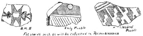
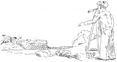
Then, in that far distant day, the process of discovery might still continue. The ruins discovered in our day, might be rediscovered again for all the evidence there is to show that some of them exist. It is unfortunate that, except for the published notes of the archeologist, the records of the archeological sites of the Mesa Verde are inadequate. Some sites are recorded in snapshots lost in a bureau drawer, others are reported in letters to a friend long since dead, still others are recorded only in the memory of the men who saw them. The badger and the red ant, of course, have made no notes at all. The present data on the archeological resources shows, not the number or distribution of sites, but rather only the significance of their occurrence. We know, for example, the remains of Basket Maker homes have been found on the Mesa Verde, but we do not know in what profusion, nor in what areas, nor beyond reasonable estimate, the period of Southwestern prehistory to which they belong. We know, again, that the Cliff Dwellers built dams to impound water, but not knowing the numbers and situation of the reservoirs we cannot even guess whether they did it on sufficiently large scale to provide water for irrigation. We know that there are uncounted numbers of surface pueblos on the mesas, but we do not know what historical relation they bear to one another and to the cliff ruins in surrounding areas. As a matter of fact, we do not know exactly just where most of them are. The data collected thus far shows one significant fact: that on the Mesa Verde there are preserved, in caves and in mounds, at least ten centuries of history of Indians of the Southwest. It is distressing, in the light of such knowledge, to find that the data concerning the sites themselves are so fragmentary and scattered so much like a book of facts without an index. The lack of information about the archeological sites is constantly apparent. The ranger guides have to guess with the tourists as to the number, location, and historical importance of the cliff dwellings; of the pit houses; or of the towers. The architect plans a development area, which if constructed would result in destruction of an ancient city that is in ruin, in an area that was no less ideal for development in prehistoric times than it is now. The engineer, locating a road in a new area of the Park must at considerable delay and expense, discover the ruins as he goes and lay out the road to avoid them. The incompleteness of the records has impeded, most important of all, the educational work within the Park. In presenting the story of the Mesa Verde to the public, especially to those thousands of visitors who are here perhaps only once in a lifetime, it is important that they should carry away with them the most accurate information about the ruins, and the most authoritative historical picture of them that may be had. It is for these several reasons that a special survey of sites within the Mesa Verde area has been proposed. It is to supply factual information for educational work, for scientific investigations, and for the administration and development of the area for the public. Because it is intended to accomplish within two years what the red ant could not do in less than a thousand, that is, to locate, identify, and describe the archeological resources of the Mesa Verde, this survey might be called a procedure for premeditated discovery. The reconnaissance will establish a system of notation to identify each site to the exclusion of all others, and a procedure for recording and collecting archeological data that will be usable for scientific study. To meet the requirements mentioned above the completed notes on any archeological site that is examined in the course of the reconnaissance should establish the location of the site on a map; show its geographical position; and show it by such a symbol as will readily denote its architectural type. A detailed record of the site, in drawings, photographs and descriptive notes must be sufficiently detailed to show, especially when necessary, the tale of preservation. Of first importance is the identification of the sites. Each site is to be marked with a metal disk on an iron stake. The disk is stamped with the serial number of the site, the name of the organization conducting the reconnaissance, and the year in which the identification was made. The site is given a serial number in every instance, irrespective of whether the site is newly discovered or whether it already has one of those picturesque names conferred by the early explorers. The location of archeological sites is to be done by the simplest method that will yield satisfactory results. Several methods might be used. To locate a ruin by means of the naked eye and a sketching pencil and the best judgment of the observer is scarcely adequate, particularly in timbered areas where there are no natural landmarks to show the position either of the ruin or of the artist. To locate the sites by the use of a transit or plane table would be expensive and slow and would yield results much more precise than are required. The most feasible method is to make the survey with a pocket transit and a stadia telescope. Such a survey, when plotted on the map will show the position of the ruin with a degree of precision that is consistent with the map itself. Further, in the event that someone desires to relocate some site in the field, it can readily be done from the survey notes. The control for the survey is the topographical map made by the United States Geological Survey. For plotting the position of ruins, it is ideal. When the survey is completed the archeological sites will appear, not as spots on a white sheet of paper, but as a control map in which the ruins themselves, and the canyons, the mesas, and the drainage areas, will show their relation to one another. The use of characteristic symbols to designate architectural types will show the distribution of the several types of ruins where such distribution exists on points of high elevation, on narrow ridges, on broad table lands, in caves or on the canyon floors or talus slopes. The detailed records are made to show the size and shape of the site, its general character, its archeological features, its state of preservation, and its contents. The perfect method for collection of such information would be to build a colossal museum, and in that to reproduce each site full size so that an investigator might compare Cliff Palace and Spruce Tree House side by side. The next best method, and the one proposed for the reconnaissance is to reproduce the sites on paper. Here again, as in the location, a choice of methods is offered. For the reconnaissance photography provides the best means for recording antiquities. It is rapid, and for supplying information one picture can tell more about a ruin than volumes of description. Further, descriptive records of the appearance of a ruin can be interpreted in as many different ways as there are people to read them. To show the external appearance of a ruin, to show special features within it, and to show the state of preservation, photography is in valuable. Descriptive notes, however, have a place in the records. For each site a standardized set of notes is kept. In tabulated form, factual information is recorded. Briefly, the location of the site is noted; its longitude and latitude, its elevation, its position, its relation to natural landmarks, and to drainage systems and vegetation. In more detailed form, the ruin itself is described—its dimensions, shape, architectural type, its archeological features, its contents; any pertinent information, in fact, that may be found without recourse to excavation, such as wood specimens suitable for tree-ring dating, skeletal material, and painted decorations. And finally, special attention is given to the state of preservation of the site. Destructive forces, such as the burrowing of animals, erosion, frost action, plant growth, tourist travel, and unauthorized excavation are noted. Recommendations are made when the need for protection and repair is urgent. Information useful to repair and protective forces is noted, for example, location of a water supply, building material, and the accessibility of the site itself. To supplement the photographs and written records, a plan drawing is made of each site. It shows the true shape and extent of the site, the position of trails, the provenience of trees, rocks, and other physical features, and serves the same purpose for the detailed record that the topographical map serves for the reconnaissance as a whole. On the plan drawing are noted the position and the angle of view of the camera for each picture; the position of special features such as wood specimens, artifacts, crumbling walls; of anything in fact to which it is desired to call special attention. In accordance with present practice for archeological reconnaissance in the Southwest, collections of potsherds will be made on every site. They provide the best material for study, when in a large area the cost of extensive excavation is prohibitive, or unwarranted. A study of the sherds from caves or surface sites will identify the cultural phase to which the ruin belongs, and will sometimes permit very precise classification. Sherd collection will be made whenever possible, and in addition to these, other artifacts will be collected when it is evident that they would be lost if left undisturbed. When the reconnaissance is completed, when the records are filed and data has been evaluated by experts in the archeological field; then its purpose will have been fulfilled. It will represent, in true relation to the geographical area in which they occur, the archeological resources of the Mesa Verde. Most important of all, this procedure for premeditated discovery will do away with the confusion of miscellaneous records, and eliminate, to a that have been the result large extent, the destruction of sites of accidental discovery.
| ||||||
| <<< Previous | > Cover < | Next >>> |
vol6-1c.htm
14-Oct-2011