GEOLOGICAL STORY OF "THE MOUNTAIN"
 The peaceful Pacific - so called - is encircled by a series of volcanic
peaks from the Aleutian Islands to the north, down either side of the
great sea to Mt. Erebus near the South Pole. Many of these are active
while others have been dead or dormant for centuries -- only their great
cones which loom above the surrounding country standing as monuments to
Nature's power in her wildest moods. Mt. Rainier is one of these, being
built by succeeding eruptions in times past, but now regarded as dead.
Yet there are warm springs at its base and steam and sulphur gases arise
from within the rim of the snow filled crater at the summit.
The peaceful Pacific - so called - is encircled by a series of volcanic
peaks from the Aleutian Islands to the north, down either side of the
great sea to Mt. Erebus near the South Pole. Many of these are active
while others have been dead or dormant for centuries -- only their great
cones which loom above the surrounding country standing as monuments to
Nature's power in her wildest moods. Mt. Rainier is one of these, being
built by succeeding eruptions in times past, but now regarded as dead.
Yet there are warm springs at its base and steam and sulphur gases arise
from within the rim of the snow filled crater at the summit.
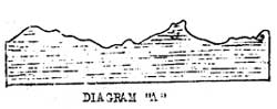
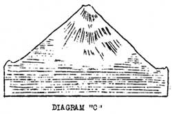
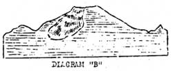 At one time in past ages (see Diagram "A") the region which is now Mt.
Rainier Nat'l Park was composed of a series of rather low, granite
ridges. Then through a weak point in the earth's crust the first lavas
flowed (see Diagram "B"), gradually lava flows accounts, in a measure,
for the tread base of Mt. Rainier -- a base which covers 100 square
miles in area -- for their viscuous character caused them to spread out
over a wide area. Later on more explosive material was embodied in its
outbursts and this material, blown high in the air, cooled rapidly and
upon falling to earth built a cone of steeper contour which, scientists
tell us, was approximately 2000 feet higher that the summit of the
"Mountain" today (see Diagram "C"). Then during some violent eruption
the upper portion of the cone was destroyed, exposing a giant caldera
about three miles across, so that Rainier today from certain angles
appears like a huge stump (see Diagram "D"). Later and feebler
eruptions built a minor crater within the caldera and it is from its rim
that the present steam and gases arise.
At one time in past ages (see Diagram "A") the region which is now Mt.
Rainier Nat'l Park was composed of a series of rather low, granite
ridges. Then through a weak point in the earth's crust the first lavas
flowed (see Diagram "B"), gradually lava flows accounts, in a measure,
for the tread base of Mt. Rainier -- a base which covers 100 square
miles in area -- for their viscuous character caused them to spread out
over a wide area. Later on more explosive material was embodied in its
outbursts and this material, blown high in the air, cooled rapidly and
upon falling to earth built a cone of steeper contour which, scientists
tell us, was approximately 2000 feet higher that the summit of the
"Mountain" today (see Diagram "C"). Then during some violent eruption
the upper portion of the cone was destroyed, exposing a giant caldera
about three miles across, so that Rainier today from certain angles
appears like a huge stump (see Diagram "D"). Later and feebler
eruptions built a minor crater within the caldera and it is from its rim
that the present steam and gases arise.
But as succeeding eruptions increased the altitude of "The Mountain" the
moisture laden winds sweeping in from the Pacific dropped their moisture
in the form of snow upon its broad slopes -- giving rise to the glacial
system that at one time extended down beyond the Mountain to meet the
Puget Sound lobe of the great Ice Cap that had advanced from the north.
With the recession of the ice cap the glaciers of the entire region,
including those of Mt. Rainier, receeded also until today they are but
remnants of their former selves. Those of Mt. Rainier remain
outstanding largely because of the continued and excessive snowfall upon
its flanks.
 But as "The Mountain" was built by fire it is being gradually torn apart
by the opposing force -- water, in the form of glacial ice. The
glaciers as they move slowly downward dig deep canyons, stripping the
"Mountain" of its outer lavas until today, instead of a smooth,
symetrical cone we find a rugged peak whose flanks are seamed with great
gorges, many of which hold glaciers that are even yet continuing their
work of grinding the ground up particles away toward Puget Sound via the
rushing mountain streams that originate at the snouts of these glaciers.
It has been estimated that fifty cubic miles of material has been cut
and carried away from the slopes of Mt. Rainier in past years by these
glaciers -- needless to say such action has left a visible impression to
the power of this moving ice.
But as "The Mountain" was built by fire it is being gradually torn apart
by the opposing force -- water, in the form of glacial ice. The
glaciers as they move slowly downward dig deep canyons, stripping the
"Mountain" of its outer lavas until today, instead of a smooth,
symetrical cone we find a rugged peak whose flanks are seamed with great
gorges, many of which hold glaciers that are even yet continuing their
work of grinding the ground up particles away toward Puget Sound via the
rushing mountain streams that originate at the snouts of these glaciers.
It has been estimated that fifty cubic miles of material has been cut
and carried away from the slopes of Mt. Rainier in past years by these
glaciers -- needless to say such action has left a visible impression to
the power of this moving ice.
MT RAINIER'S GLACIERS
Twenty eight glaciers are included in the glacial system of this
mountain -- it is considered the greatest glacial system radiating from
a single peak in the United States, and when we consider that the ice
area on "The Mountain" is about 45 square miles we can easily understand
why it has this distinctive. Of the twenty eight glaciers, six
originate from the neve field at the summit and are thus termed
"primary" glaciers. Many of them too, are "live" -- that is they move
slowly down the mountainside. However the melting at the snout is
greater than the movement downward and as a matter of fact they are
gradually losing ground -- receeding. This is illustrated in the case
of the Nisqually whose recession has been tabulated for a period of
years. It shows that, in spite of the downward movement, the Nisqually
Glacier actually receeds on the average of 40 feet per year. From
October 1927 to October 1928 it lost 89 feet. While six of these
glaciers originate from the neve field the majority have their source at
about 10,000 or 11,000 feet in elevation in great cirques, or bowls that
have been carved out by these glaciers. Such is the origin of the
Carbon Glacier -- the one that extends farther down upon the slopes of
the "Mountain" than any other.
The Emmons Glacier in the White River district is the largest on Mt.
Rainier and of course the largest in the United States. It is one and
one half miles wide at its widest point and approximately five and one
half miles long.
Click to see a copy of the original pages of these
articles (~250K)