|
|
||||||
|
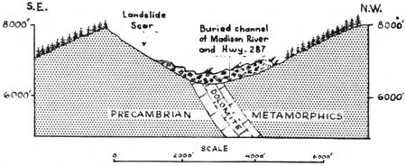
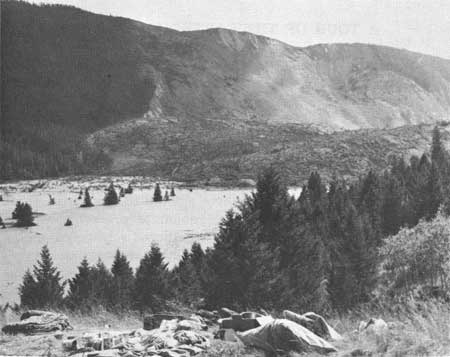
A TOUR OF THE EARTHQUAKE AREA Effects of the 1959 earthquake can best be followed by reference to Plate 37 where numbered sites are described in numerical sequence. SITE 1. The Madison River at this point has carved a deep gorge through the heart of the Madison Range. Steeply inclined metamorphic rocks of Precambian age dip to the north. Prior to the earthquake a buttress of dolomite precariously supported a mountainside of deeply weathered schist and gneiss. Conditions were favorable for landslides to occur. It is believed that earthquake vibrations shattered the dolomite buttress, the mountainside came down in one roaring mass, rose 400 feet vertically up the north wall and came to final rest in the canyon. The rapid emplacement of this 80 million tons of rock in the narrow confines of the canyon sent an air blast of cyclonic proportions that added to the fury of nature on a rampage.
SITE 2. The landslide which dammed the Madison River created "Earthquake Lake" between the slide and Hebgen Dam.
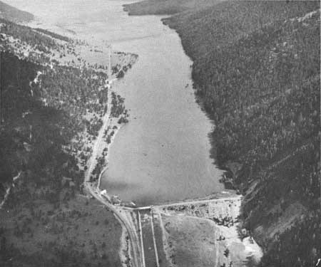
SITE 3. Hebgen Lake Dam, an earthfill structure with a concrete core wall, built in 1913 by the Montana Power Company, was cracked in several places and inundated four times by a wall of water set in motion by the agitation of the lake basin. Lake oscillations of this type are known as seiches.
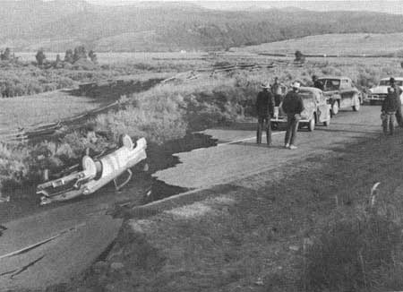
SITE 4. Old faults were reactivated along the north side of the lake, portions of the lake shore slumped, and the whole lake basin was tilted so that the north side depressed and the south side was elevated.
At the Duck Creek Wye, Highway 191 was offset by a fault and a family fleeing from the scene of devastation ran from one peril into another. Fortunately none were injured when their car overturned.
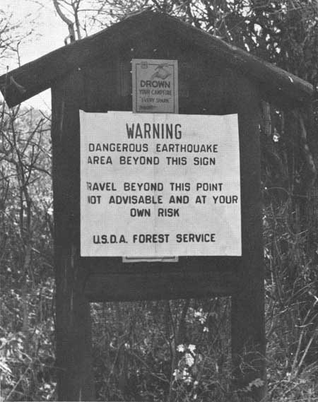
With repeated aftershocks it seemed wise to curtail travel and signs like this were erected.
SITE 5. West District Ranger Elliot Davis1 found himself in the center of activity,
All rangers and men in the area reported for duty at once, buildings in the government area were inspected, the fire truck was started in anticipation of fire and a quick tour of the town of West Yellowstone was made. The West Entrance to Yellowstone Park was immediately closed to incoming traffic while a procession of cars began to wend its way from Madison Junction toward the gate. Campers roused from their sleep hastily stuffed their belongings into cars and were slowly working a route around rockslides and through the dust filled air of the Madison Canyon.
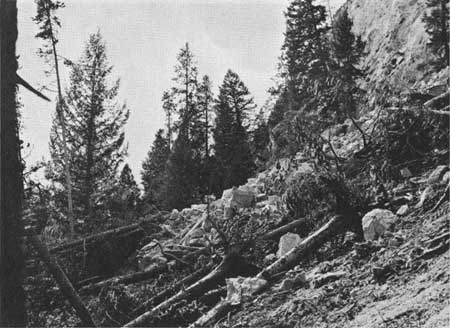
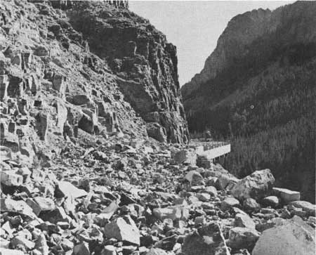
SITE 6. The north and south walls of the Madison Canyon were severely shaken by earth tremors and great blocks of rock shattered from the canyon rim, cut swathes through the timber as they cascaded down to the roadway below. Boulders the size of an automobile bounded by leaps and jumps, some ending up in the Madison River to nestle among lichen-covered rocks of comparable size brought down by a similar event in the not too distant past. Choking clouds of pulverized volcanic ash dust filled the air.
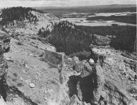
One more chapter had been written in a process that has been going on here for millions of years. A few days after the earthquake I climbed through these slides to the summit of Mt. Jackson searching for rifting of the cliff face that might create a danger in opening the road below. None was found and to my total amazement there was no evidence of movement back of the cliff, not a pine needle disturbed or a log rolled over! The Madison Canyon has been established along the contact of a plateau flow with a fault scarp. A normal fault, upthrown on the north side, has been mapped (Plate 36) from near the base of Mt. Jackson in an easterly direction through Madison Junction following the Gibbon River and Canyon Creek, thence north to die out in the Gibbon Meadows. The bold south face of Mt. Jackson and Purple Mountain have been eroded out of welded tuff on the fault scarp. South of the Madison River, Mt. Haynes and National Park Mountain are the front of a rhyolite plateau flow and the welded tuffs underlie them but are not exposed as this is the downthrown side of the fault. A branch fault cuts through Secret Valley to create a downdropped block or graben.
The Secret Valley, Madison Canyon, and Gibbon Falls area, because of their fault control and proximity to the epicenter, show some of the greatest earthquake effects. SITE 7. A short distance east of Madison Junction the road passes near Tuff Cliff where a hillside was shattered by the earthquake and trees were knocked over by the rockslide. When movement occurs along a fault the wall rock is smoothed, polished and grooved in a direction parallel to the displacement. Rocks grooved in this manner are said to be slickensided. At the base of Tuff Cliff there are slickensided boulders of tuff broken from an old fault surface (Plate 36) by the 1959 earthquake. The apparent freshness of the striations on a rock as soft as tuff is proof of comparatively recent movement. However, limited observations to date reveal no evidence of renewed faulting in this locality during the 1959 earthquakes.
On the 30th of September 1959, Park Naturalists Mebane and Frisbee visited Secret Valley and found a large mudflow had occurred in the northwest corner of the valley which had moved downslope with sufficient force to uproot trees and create large log jams.
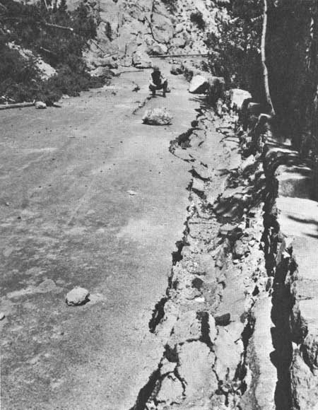
SITE 8. The route of the Gibbon River from Gibbon Meadows to its confluence with the Firehole River at Madison Junction is essentially fault controlled throughout its course. Gibbon Falls is critically situated in the downfaulted block known as Secret Valley. Shock waves from the August 17 earthquake seem to have channeled their energy in this area causing new thermal activity and extensive road damage by rockslides and fracturing of the road cover.
SITE 9. The Firehole River, fed by Madison Lake, follows a northerly course through the Upper, Midway and Lower Geyser Basins. Tributary streams and discharge from the thermal areas increase its volume downstream. As the river leaves the lower Geyser Basin it has dissected its canyon through zones of weakness in one of the rhyolite plateau flows. At Firehole Falls the canyon wall rock consists of poorly lithified masses of perlitic rhyolite and obsidian. Earth tremors shattered this material and the ensuing rockslide completely buried the road. There is no evidence for fault control at this point and the slides apparently were caused by the nature of the rock and its inability to withstand the vibrations. Fortunately the old Mesa Road was undamaged and this provided a route of travel around the slide area and permitted people to vacate the Madison Junction campground.
SITE 10. The Twin Buttes in the southwest corner of the Lower Geyser Basin, are hills of glacial drift cemented by siliceous sinter from pre-glacial hot spring and geyser action. Fumaroles are still active on both hills. Park Rangers Frisbee and Mebane visited this area on September 25, October 14, and November 19, 1959, and reported the presence of large steaming cracks on both buttes which they believed to be the result of massive slumping initiated by the earthquake. Study of Mebane and Frisbee's tape and compass map of the fractures reveals several large fissures with depths of six to fifteen feet and smaller ones with lengths up to 350 feet. Many of these are now active fumaroles. Rifting of Twin Buttes would be expected because with every earthquake the damage is greatest in poorly consolidated alluvial deposits.
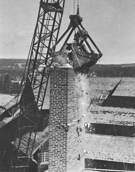
SITE 11. Visitors in the Old Faithful area were jolted by the shocks with the Inn bearing the brunt of the damage. At 1:43 A.M. the chimney over the Inn dining hall collapsed and fell through the roof. A sprinkler system was activated in one wing, other chimneys were damaged and the danger of falling brick led to the evacuation of the building.
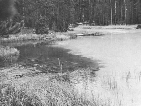
Visitors in the west wing were allowed to reoccupy their rooms, however few chose to do so. At 7:30 A.M. a barricade on the Old Faithful-West Thumb road was removed and people were advised by public address system that they could leave the park by all entrances except the West. SITE 12. From Canyon to Norris Junction the road follows a course through dense stands of lodgepole pine on the Solfatara Plateau. At Virginia Cascades on the Gibbon River the road becomes a shelf road with log cribbing for support and it has been cut back into a jointed exposure of rhyolite. Small rockslides took place here and the road was closed to public travel by an order of the Superintendent. Minor damage was recorded at Norris. A chimney fell in on the old Soldier Station and some glass broke in the museum. SITE 13. Immediately after the earthquake it became apparent that a great many streams and lakes were muddied up as a result of jarring of the ground water table. Compaction of alluvial material results in a reduction in pore space and the water drives out the finer sedimentary particles. In some areas mud slides added to the problem. Most of the drainage on the west side of the park was murky and Grizzly Lake and Straight Creek were exceptionally turbid. This condition persisted and one month after the earthquake Park Naturalists Germeraad and Mebane found Grizzly Lake still uniformly muddy and cold. Springs flowing into the lake from the west shore were clear and cold, but Straight Creek flowing into it from the south, was even muddier than the lake.
SITE 14. Golden Gate Bridge of cantilever construction was completed by the National Park Service in 1934. The road at this point has been cut back into exposures of welded tuff that are crudely jointed.
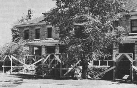
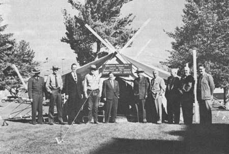
Earthquake tremors shattered blocks of tuff and a rock slide descended onto the bridge and covered the road. Fortunately once again a back road was undamaged and travel from Norris to Mammoth was possible by way of the Bunsen Peak road. SITE 15. Mammoth Hot Springs is headquarters for Yellowstone National Park. Here Mr. Lemuel A. Garrison, Park Superintendent, and his staff direct the activities essential to the operation of the oldest and largest of our national parks. The community of Mammoth was rocked by the initial shock with damage to buildings caused largely by falling chimneys. Road crews set out at once to check the status of a rockslide that has been slowly encroaching on the north entrance road four miles below Mammoth. This slide had not moved but a new one had developed at Golden Gate creating a road block. Startled residents gathered in small groups and were able to see rockslides cascade from the summit of Mt. Everts, the dust creating an eerie effect in the moonlight. Mt. Everts consists of stratified Cretaceous rocks that are unconformably overlain by welded tuff. Shaking of the Mt. Everts fault block resulted in rock fall from the cap. The community was jolted by aftershocks for days afterward and as a safety precaution some buildings were temporarily abandoned, board enclosures were erected for protection against falling stone and the Superintendent moved his headquarters into a tent.
SITE 16. Yellowstone River departs from Yellowstone Lake at Fishing Bridge and commences a leisurely journey across the Hayden Valley. Gradually the river changes from a placid body of water to a seething torrent as it picks up speed to descend in a foaming cascade over the Upper and Lower Falls. Here in all its pristine beauty is the Grand Canyon of the Yellowstone. The canyon has been dissected through rhyolite flows that have been intensely altered by an earlier period of geyser and hot spring action. Rock decomposition in every stage from slightly altered rhyolite to pure kaolin can be seen throughout the colorful portion of the canyon. Conditions here are favorable for rockslides. Clouds of dust were observed at a few localities in the vicinity of Artist's Point but close inspection reveals little if any damage. Increased distance from the epicenter probably saved the canyon from destruction. However, an aftershock of early September did cause some rock to tumble down on Uncle Tom's trail necessitating its closure for public safety. | |||||||||
| <<< Previous | > Cover < | Next >>> |
nature_notes/yell/vol33m.htm
31-Mar-2006