|
Alibates Flint Quarries National Monument Texas |
|
 NPS photo | |
Most signs of North America's earliest people have disappeared forever. The simple questions about the foods they ate, the homes they lived in, and the languages they spoke are still unanswered. In most cases their own remains have vanished, too. Often the only traces of human existence thousands of years ago are the tools and weapons these early people fashioned from stone.
Of all the different kinds of stone used in making tools, one of the most distinctive is Alibates flint. Normally flint has one characteristic shade, but Alibates flint has a multitude of bright colors in endless variations and patterns.
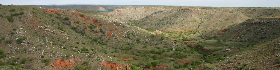
Archeologists find tools made of Alibates flint in many places in the Great Plains and the Southwest. The stone comes from a relatively small section of the Texas Panhandle, 26 square kilometers (10 square miles) around Lake Meredith on the Canadian River. The flint, in a layer up to 1.8 meters (6 feet) thick, usually lies just below the surface at ridge level.
Using nothing more elaborate than a fine antler tip, a present-day flint chipper puts the finishing touches on a sharp point before attaching it to a shaft. A leather pad protects his hands from being cut as he applies pressure on the very edge, "pushing" off one sharp chip at a time.
To get unweathered flint out of the ground, man had to dig by hand or with sticks. Around these shallow quarry pits you can see chunks and pieces of flint, the waste materials or tailings of the quarrying operations.
Alibates flint is a hard rock that has a sharp edge when shaped properly. Early toolmakers were able to chip and flake it into an astonishing variety of everyday tools of survival. Archeologists have found knives, hammers, chisels, drills, axes, awls, fishhooks, buttons, hoes, scrapers and gravers, as well as dart points or arrowheads—all made out of Alibates flint.
Most evidence of the 12,000 years of almost continuous use of Alibates flint comes not from these quarry pits, but from archeological excavations elsewhere. From 10,000 B.C. to possibly as late as the 1870s, Alibates flint was distributed widely over the High Plains. Most people who used it were nomads—hunters who followed game trails and never built permanent homes.
For a relatively short period, from about A.D. 1200 to 1450, however, some people settled permanently near the quarries. They were farmers, but they also quarried flint and bartered it for such items as pottery, seashells, pipestone, and obsidian. These people are referred to by archeologists as the Panhandle Pueblo Culture because they were Plains Village Indians whose houses show the influence of pueblo style houses in the Southwest.
About Your Visit
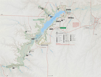 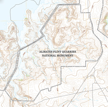 (click for larger maps) |
Check availability of Ranger-led Quarry Tours during the winter months of November–February by contacting the park. During summer months tours are offered at 10 A.M. and 1 P.M. During the season, you may visit the quarry sites by ranger-guided tour only. Tours are offered daily, as weather and staffing allows. Quarry tours typically take 2 hours and involve a moderate one-mile round trip hike. The trail to the quarries is covered in loose gravel and includes stairs. You will gain approximately 170 feet of elevation as you hike up to the quarry sites on the top of the mesa. Bring water and wear comfortable, sturdy, closed-toe walking shoes or hiking boots. It is often very windy on the mesa, so a jacket is recommended. You might also bring sunscreen, a hat, and a walking stick.
Please be mindful of your safety. Be careful when walking over loose rocks along the trails. Remember that all natural and archeological resources are protected by Federal law and the collection, removal, defacement or destruction of such irreplaceable features is strictly prohibited. Entry to Alibates National Monument is by ranger-guided tours only.
The Panhandle Plains Historical Museum, on the campus of West Texas State University, has several exhibits of archeological material from this region and a model of what a Panhandle Pueblo structure might have looked like. The museum is in Canyon, Texas, 26 kilometers (16 miles) south of Amarillo.
Source: NPS Brochure (1987)
The Allure of Alibates Flint
At the end of the last Ice Age, some 13,000 years ago, Paleo-Indians quarried flint at Alibates. From it they fashioned small, beautifully crafted spear points to hunt the big game—bison, mammoths, and sloths—that roamed the Great Plains in those cooler, wetter times. Durable, colorful, and smooth, Alibates flint breaks in a predictable pattern when struck, and can be honed to a fine, deadly point.
Points made from Alibates flint were found embedded in skeletons of mammoths unearthed in eastern New Mexico, near Blackwater Draw, a center of the early Clovis culture. Its nomadic hunters possibly came from the south, or may have crossed the Bering Land Bridge from Asia. The wide distribution of Alibates flint points suggests that Clovis people placed a high value on this stone.
Much later, between 1200 and 1450, a Plains Village subgroup, known as the Antelope Creek people, must also have recognized the beauty and utility of Alibates flint. They built masonry structures close to the flint outcroppings along the Canadian River. In the 1930s, excavations organized by the Works Progress Administration (WPA) uncovered the ruins of two structures now inside the monument. Square and rectangular rooms are probably living spaces; round rooms are possibly for storage or burial. Other remains of the now-vanished Antelope Creek culture at Alibates include petroglyphs of turtles, bison, and human feet; cord-marked pottery; and thousands of small, narrow flint arrowheads. Turquoise and shell jewelry, pipes, and obsidian also found at Alibates suggest that Antelope Creek people traded their flint with peoples to the west and north.
Many shallow pits, probably dug with sticks or tools made from bison or other bone, mark the Alibates landscape. Waste piles scattered across the dry earth near the pits contain broken and discarded tools and flint flakes—the result of knapping, or striking a flint core with a heavier, harder "hammerstone," often a river cobble.
In 1965 Congress proclaimed Alibates a national monument, the only one in Texas, to preserve the native peoples' quarries and other records. You may visit the flint quarries only by ranger-led tour; reserve in advance.
ALIBATES FLINT QUARRIES NATIONAL MONUMENT is open daily 9 am to 4 pm. Closed Thanksgiving, December 25, and January 1. You may visit the quarries only by ranger-led tour. Reservations are required. Tours are one mile long with several flights of stairs (elevation gain 170 feet). No entrance fee.
Source: NPS Brochure (2014)
|
Establishment
Alibates Flint Quarries National Monument — November 10, 1978 |
For More Information Please Visit The  OFFICIAL NPS WEBSITE |
Documents
An Evaluation of Antelope Creek Phase Interaction Using INAA (©Holly A. Meier, Masters Thesis Texas State University-San Marcos, May 2007)
Archeological Assessment of Alibates National Monument (C. Britt Bousman, April 1974)
Architecture and Community Variability Within the Antelope Creek Phase of the Texas Panhandle (©Christopher Ray Lintz, Ph.D. Thesis University of Oklahoma, 1984)
Archeological Investigations Along The Proposed Alibates Tour Road (Jack B. Bertram, August 1989)
Culture Complexes and Chronology in Northern Texas With Extension of Puebloan Datings to the Mississippi Valley The University of Texas Publication No. 4640 (Alex D. Krieger, October 22, 1946)
Foundation Document, Alibates Flint Quarries National Monument, Texas (April 2014)
Foundation Document Overview, Alibates Flint Quarries National Monument, Texas (June 2014)
General Management Plan Amendment: Alibates Flint Quarries National Monument, Texas (March 5, 1985)
Geologic Map of Lake Meredith NRA and Alibates Flint Quarries NM, Texas (G.K. Eifler, Jr. and V. E. Barnes, 1969)
Geologic Resources Inventory Report, Lake Meredith National Recreation Area and Alibates Flint Quarries National Monument NPS Natural Resource Report NPS/NRPC/GRD/NRR-2015/146 (K. KellerLynn, September 2015)
Herpetofauna of Lake Meredith National Recreation Area and Alibates Flint Quarries National Monument and the Vicinity (Potter, Hutchinson, and Moore Counties, Texas) Museum of Texas Tech University Occasional Paper No. 274 (Michael Patrikeev, June 9, 2008)
Junior Ranger Activity Book, Alibates Flint Quarries National Monument/Lake Meredith National Recreation Area (Date Unknown; for reference purposes only)
Junior Ranger Activity Booklet, Alibates Flint Quarries National Monument/Lake Meredith National Recreation Area (June 2004; for reference purposes only)
Master Plan, Alibates Flint Quarries and Texas Panhandle Pueblo Culture National Monument, Texas (March 1973)
Natural Resource Condition Assessment, Lake Meredith National Recreation Area/Alibates Flint Quarries National Monument NPS Natural Resource Report NPS/SOPN/NRR-2016/1124 (Kimberly Struthers, Patricia Valentine-Darby, Nina Chambers, Allyson Mathis, Donna Shorrock, Robert E. Bennetts and Tomye Folts-Zettner, January 2016)
Paleontological Resources of Lake Meredith National Recreation Area and Alibates Flint Quarries National Monument, West Texas New Mexico Geological Society Guidebook, 52nd Field Conference (Adrian P. Hunt and Vincent L. Santucci, 2001)
alfl/index.htm
Last Updated: 01-Jan-2025