|
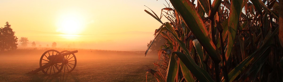
Antietam National Battlefield Maryland |
|
 NPS photo | |
Antietam: the bloodiest one-day battle of the American Civil War
A year and a half into the Civil War, Union victory was far from assured. Confederate forces were fighting successfully in the Eastern Theater (comprising operations mainly in Virginia). After his victory at the Second Battle of Manassas (Bull Run), Confederate Gen. Robert E. Lee decided to move his army out of war-torn Virginia. On September 4, 1862, he led his over 40,000 Confederates across the Potomac River and through the lush Maryland countryside to Frederick.
Lee's Maryland Campaign—his first foray onto Union soil—was the most significant in a series of loosely coordinated Confederate incursions along a 1,000-mile front. Lee intended to keep moving north into Pennsylvania, but his line of supply and communication into Virginia was threatened by the 12,500-man Union garrison at Harpers Ferry, Va. (now West Virginia). Lee therefore divided his army to neutralize this threat. Part of Gen. James Longstreet's command went to Hagerstown, Md., close to Pennsylvania. Three columns led by Gen. Thomas J. "Stonewall" Jackson surrounded Harpers Ferry and held Crampton Gap on South Mountain. A third force, Gen. D.H. Hill's command, guarded the South Mountain gaps near Boonsboro, Md.
On September 12, Union Gen. George B. McClellan led the Army of the Potomac into Frederick, Md., just as the last Confederate soldiers were departing. Over the next few days a chain of events would draw all of these men together for the bloodiest one-day battle of the Civil War.
On September 13 a Union soldier found a copy of Lee's Special Order 191, his plan of operations for the campaign. This "Lost Order," as it has become known, was taken to McClellan, who realized that this was the time to strike Lee's divided forces. On the morning of September 14, Union soldiers engaged Confederates guarding the gaps on South Mountain. The day-long battle ended with the Confederates being forced from the gaps.
Lee considered returning to Virginia, but on September 15, after learning that Harpers Ferry had fallen, he reevaluated his plans. He would make a stand at Sharpsburg, Md., a quiet, 100-year-old farming community of some 1,200 residents.
That night we lay in line of battle behind a small brick church called the Dunkers Church, situated on the Hagerstown Turnpike, with arms, and ready to move at any moment.
—William Snakenberg, Private, 14th Louisiana
Aftermath and Significance
For the people of Sharpsburg, the battle and presence of thousands of soldiers caused sickness and death from disease, and great property damage. Antietam made feasible the Emancipation Proclamation and reshaped the logistics of field medicine. It also influenced how the nation would memorialize battlefields in the future.
Immediately after the battle over 3,500 dead were buried in farm fields surrounding Sharpsburg. Eventually Confederate soldiers were moved to three local cemeteries. Union men were re-interred in Antietam National Cemetery, their names (if known) recorded in a book.
Seeing the bandages, lanterns, and food Clara Barton brought to his Antietam hospital, Surgeon Charles Dunn christened her "The Angel of the Battlefield." In 1881 Barton founded the American Red Cross. She not only provided neutral assistance to soldiers in war but conceived and put into practice the provision of aid to civilians after natural disasters.
The Emancipation Proclamation, released January 1, 1863, reshaped the war, freeing slaves in states in rebellion and giving the Union war effort two goals: preserve the Union and end slavery. Slaves could flee to Union camps and freedom or even join U.S. fighting forces. Lee's repulse at Antietam enabled the proclamation, and the two events kept Great Britain from intervening for the Confederacy.
Hospitals were set up in barns, churches, homes, and make-shift tents to care for over 17,000 wounded soldiers. The Hagerstown newspaper called the area "one vast hospital."
"Comrades with wounds of all conceivable shapes were brought in and placed side by side as thick as the could lay, and the bloody work of amputation commenced."
—Union Soldier George Allen
The battle created a legion of amputees.The shovel buried many dead, who often awaited burial for davs, laid out as though they died in their battle ranks.
A revolution in combat medical care was put in place just weeks before this battle. Dr. Jonathan Letterman, chief medical officer, Union Army of the Potomac, established an ambulance corps to evacuate the wounded. He also adopted triage—a system of prioritizing casualties by the severity of their wounds.
"... when bullets are cracking skulls like eggshells, the consuming passion ... is to get out of the way."
—Union Pvt. David L. Thompson
The Battle of Antietam
On September 15, 1862, Confederate Gen. Robert E. Lee positioned his army along a ridge west of Antietam Creek. Confederate Gen. James Longstreet commanded the line's center and right, and Gen. Thomas J. "Stonewall" Jackson held its left. Behind them a Potomac River ford allowed retreat to Virginia. On September 15 and 16 union Gen. George B. McClellan deployed his forces east of the creek. His plan: attack Lee's left and when "matters looked favorably" attack the Confederal's right. Succeeding in either he hoped to strike Lee's center. His plan was good but his instructions to commanders ambiguous.
The 12-hour battle began at dawn, September 17. Three morning Union attacks struck the Confederate left, north to south. Gen. Joseph Hooker's First Corps made the initial assault, followed by Gen. Joseph Mansfield's Twelfth Corps. Part of Gen. Edwin Sumner's Second Corps made the final attack. McClellan's battle plan broke down in uncoordinated advances. From 6 am until 10 am savage combat raged across the Cornfield, East Woods, and West Woods. By late morning fighting shifted toward the Confederate center (Sunken Road) in a three-hour stalemate that left the road forever known as "Bloody Lane." Most contested of the three bridges Union forces used to cross Antietam Creek was the lower. At 10 am Union Gen. Ambrose Burnside's Ninth Corps began its assaults on the Lower Bridge. By 1 pm Federals had driven the Confederates from the bluff overlooking the creek. Over the next two hours Burnside moved his men across the bridge and deployed them. When he again advanced on the Confederate right. Gen. A.P. Hill's reinforcements, arriving in late afternoon from Harpers Ferry, stopped him. The battle ended about 6 pm. The lines of battle had not shifted significantly from that morning. Of nearly 100,000 soldiers engaged in battle, about 23,000 were killed, wounded, or missing. Late on September 18, Lee forded the Potomac to Virginia. The Union Army held the field.
Touring Antietam Battlefield
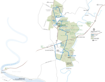 (click for larger map) |
Dunker Church Built in 1852, this modest house of worship for pacifist German Baptist Brethren became a focal point for Union attacks the morning of the battle.
North Woods Union Gen. Joseph Hooker's men spent the night before the battle on the Poffenberger farm. At first light the Union attack advanced south from here toward Jackson's lines. "The stars were still shining when [Hooker's] skirmishers became engaged," a soldier would later recall.
East Woods A small engagement took place in this area the night before the battle. The fighting also opened here early on September 17 as Union and Confederate soldiers exchanged deadly musket volleys, vying to control these woods.
Cornfield This 24-acre cornfield saw some of U.S. history's most horrific fighting. For nearly three hours Hooker and Mansfield's Union forces battled Jackson's Confederates. Many regiments on both sides were cut to pieces. Hays' Louisiana Brigade suffered over 60-percent casualties in 30 minutes.
West Woods Around 9:30 am Gen. Edwin Sumner's Union soldiers advanced into the West Woods. The combined firepower of Confederate artillery and attacking infantry drove them back. In 20 minutes over 2,200 Union soldiers were killed or wounded.
Mumma Farm and Cemetery The only deliberate destruction of property during the battle was the burning of this farm. Confederate soldiers were ordered to burn these structures to prevent their use by Union sharpshooters. Fortunately, Samuel Mumma and his family had fled to safety before the battle. The Mumma family rebuilt the home in 1863.
Union Advance During mid-morning nearly 10,000 Union soldiers moved across the Mumma and Roulette farms toward the Confederate center at Sunken Road. Two Union soldiers were awarded Medals of Honor for bravery in these attacks.
Sunken Road (Bloody Lane) This farm lane served as a breastwork for the Confederate center. For about three hours 2,200 Confederates, later reinforced by additional troops, held off the attacks of a combined Union force numbering nearly 10,000. Finally, just after noon, this thin gray line collapsed and fell back several hundred yards to the Piper Farm. The Union attackers had suffered too many casualties to pursue their advantage. Seeing the dead in the road an observer wrote, "They were lying in rows like the ties of a railroad, in heaps like cordwood mingled with the splintered and shattered fence rails. Words are inadequate to portray the scene."
Lower Bridge (Burnside Bridge) About 500 Confederate soldiers held the area overlooking the Lower Bridge for three hours. Burnside's command finally captured the bridge and crossed Antietam Creek, which forced the Confederates back toward Sharpsburg.
Final Attack After taking the Lower Bridge, Burnside moved across these fields from east to west, pushing back the Confederate right flank. Just as it appeared that Lee's line was breaking. Confederate Gen. A.P. Hill's Light Division arrived from Harpers Ferry to drive Burnside back to Antietam Creek.
Antietam National Cemetery This hill was occupied by Confederate artillery—neither this nor the town cemetery across the road were here in 1862. At first the dead were buried where they fell on the battlefield. Later they were reinterred here, along with Union soldiers who died in combat or in hospitals throughout the region. A total of 4,776 Union soldiers rest here along with dead from four other wars. Separate even in death, Confederate soldiers were buried in Hagerstown and Frederick, Md. and Shepherdstown, Va., now West Virginia.
Visiting Antietam Battlefield
Antietam Battlefield lies north and east of Sharpsburg, Md., along Md. 34 and 65. The visitor center, north of Sharpsburg on Md. 65, is open daily except Thanksgiving, December 25, and January 1. Before starting your tour, stop at the visitor center to see the exhibits and AV programs that introduce the battle and the Maryland Campaign. Visitor center facilities and most tour route exhibits are wheelchair-accessible. The park closes 20 minutes after sunset.
There are interpretive markers at Turners, Fox, and Crampton gaps on South Mountain and at the ford near Shepherdstown, W. Va., where much of Lee's army recrossed the Potomac River.
Safety and Regulations While touring the park stay alert to traffic. Bicyclists should use caution descending hills. Please use trails to minimize contact with stinging nettles, ticks, and snakes. Do not climb on cannon, monuments, fences, or trees. Relic hunting is prohibited.
Source: NPS Brochure (2014)
|
Establishment
Antietam National Battlefield — November 10, 1978 |
For More Information Please Visit The  OFFICIAL NPS WEBSITE |
Documents
Analysis of the Visible Landscape, Antietam National Battlefield, Maryland (April 1988)
Antietam National Battlefield and National Cemetery, Sharpsburg, Maryland: An Administrative History (Charles W. Snell and Sharon A. Brown, 1986)
Antietam National Battlefield Landscape Management Plan Environmental Assessment (July 2022)
Archeological Overview, Assessment, Identification, and Evaluation Study of Newly Acquired Lands at Antietam National Battlefield, Maryland Final Technical Report Volume I (The Louis Berger Group, Inc., June 2014)
Cultural Landscape Report: Antietam National Battlefield, Sharpsburg, Maryland (Quinn Evans, December 2021)
Cultural Landscape Report: Antietam National Cemetery, Antietam National Battlefield, Sharpsburg, Maryland (Michael Commisso, October 2014)
Cultural Landscapes Inventory: Visitor Center Area Cultural Landscape, Antietam National Battlefield (December 2018)
Foundation Document, Antietam National Battlefield, Maryland (September 2013)
Foundation Document Overview, Antietam National Battlefield, Maryland (March 2016)
Geologic Resource Evaluation Report, Antietam National Battlefield, Chesapeake and Ohio Canal National Historical Park, & Harpers Ferry National Historical Park NPS Natural Resource Report NPS/NRPC/GRD/NRR-2005/005 (T.L. Thornberry-Ehrlich, January 2005)
Historic Handbook #31, Antietam National Battlefield (Frederick Tilberg, 1960 rev. 1961)
Historic Structure Report, Samuel Mumma House, Antietam National Battlefield (Thomas A. Vitanza, June 1999)
Historic Structures Report: Mary Locher Cabin, Physical History and Condition Assessment, Antietam National Battlefield, Sharpsburg, Maryland (Architrave P.C., January 15, 2001)
Historic Structures Report: The Environs of the Dunkard Church (Part I), Antietam National Battlefield Site (Robert L. Lagemann, March 12, 1962)
Historic Structures Report/History Data: Mumma Farm - "Spring House" / Piper Farm - "Slave Quarters" / Sherrick Farm - "Smoke House", Antiteam National Battlefield Site, Maryland (Francis F. Wilshin, August 28, 1969)
History Report: The D.R. Miller Farm Antietam National Battlefield Sharpsburg, Maryland (Paula S. Reed, September 1991)
Junior Junior Ranger (Ages Under 6), Antietam National Battlefield (Date Unknown; for reference purposes only)
Junior Ranger (Ages 6-8), Antietam National Battlefield (Date Unknown; for reference purposes only)
Junior Ranger Program (Ages 9-12), Antietam National Battlefield (Date Unknown; for reference purposes only)
National Register of Historic Places Nomination Forms
Antietam National Battlefield Additional Documentation — Mission 66-Era Resources (Gary Scott, August 20, 1981)
Natural Resource Condition Assessment, Antietam National Battlefield, National Capital Region NPS Natural Resource Report NPS/NCRN/NRR-2011/413 (Jane Thomas, Tim Carruthers, Bill Dennison, Mark Lehman, Megan Nortrup, Patrick Campbell, Ed Wenschhof, Joe Calzarette, Debbie Cohen, Lindsay Donaldson and Andrew Landsman, June 2011)
Physical History and Condition Assessment: Antietam National Cemetery Lodge (architrave p.c. architects, March 5, 2003)
Resources Management Plan for Antietam National Battlefield (December 1987)
Visitor Access and Circulation Plan Environmental Assessment, Antietam National Battlefield, Maryland (July 2018)
Portraits of Antietam (2014)
anti/index.htm
Last Updated: 01-Jan-2025