|
Appalachian National Scenic Trail CT, GA, MA, MD, ME, NC, NH, NJ, NY, PA, TN, VA, VT, WV |
|
 NPS photo | |
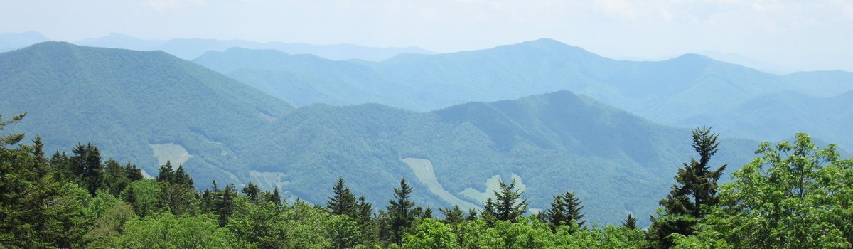
The Appalachian National Scenic Trail (A.T.) is a public footpath that follows more than 2,100 miles of Appalachian Mountain ridgelines between Maine and Georgia. Roads that cross it at varying intervals give ready access. The Trail is protected along more than 99 percent of its course by federal or state ownership or rights-of-way. It was designed, constructed, and marked in the 1920s and 1930s by volunteer hiking clubs brought together by the volunteer-based, nonprofit Appalachian Trail Conservancy (ATC). Formed in 1925 and based in Harpers Ferry, W. Va., ATC works in partnership with the National Park Service (NPS), USDA Forest Service, states, and local communities.
A "super trail" had been talked about in New England hiking circles in the early 1900s. The A.T. evolved from the 1921 proposals of Massachusetts regional planner Benton MacKaye to preserve the Appalachian crests as a wilderness belt—a retreat from urban life. The old clubs that united behind MacKaye, plus new clubs formed specifically to advance the A.T. idea, concentrated on the hiking aspects of his vision under the leadership of Myron Avery, ATC chairman from 1931 to 1952.
The clubs, two federal agencies, states, and Depression-era Civilian Conservation Corps (CCC) combined forces to open a continuous trail by August 1937. Hurricanes, highway construction, and the demands of World War II undid those efforts until 1951, when all sections were finally relocated, opened, and marked for hikers. The 1968 National Trails System Act made the A.T. a linear national park area and authorized funds for the NPS, USDA Forest Service, and states to protect the entire route with public lands. The goal is to preserve the trail and provide for visitors' enjoyment of the varied scenic, historical, natural, and cultural resources of this one-of-a-kind park.
A Footpath in Nature
Between Maine's Mount Katahdin (northern terminus) and Georgia's Springer Mountain (southern terminus), this footpath winds through the scenic, wooded, pastoral, wild, and culturally resonant lands of the Appalachian Mountains. The Appalachians—ancient, worn-down, and forested—stretch from Quebec's Gaspe Peninsula in Canada to Alabama's northern mountains. The Appalachian Trail is used for walks and day hikes by all manner of nature enthusiasts, from birders to wildflower photographers. Backpackers make weekend escapes from urbanized areas or take long-distance "thru-hikes" for months at a time.
The Appalachian Trail by States
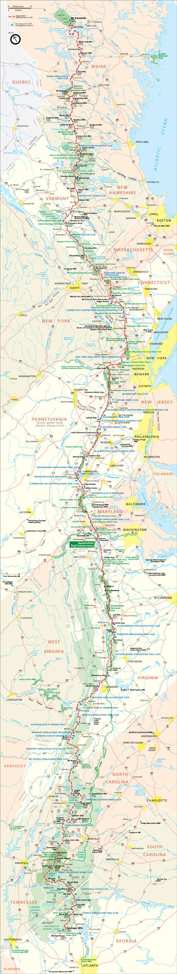 (click for larger map) |
Maine In its 281 miles across Maine, the A.T, marked throughout with vertical white-paint blazes, passes through an extensive wilderness at a great distance from towns and cities. The Katahdin region at the northern terminus is outstanding. Katahdin comes from the American Indian name Kette-Adene meaning Greatest Mountain. Farther south the rugged Mahoosuc Range stretches into New Hampshire. Opportunities for canoeing and swimming are features of the A.T. in Maine.
New Hampshire The White Mountains region is much frequented and is the main feature of the Trail in New Hampshire. Parts of the A.T. are above treeline, where temperatures may change suddenly. A trip here requires detailed planning, and you should allow ample time. The connecting link between the Green and White mountains passes through broken terrain of the Connecticut River Valley.
Vermont West of the Connecticut River to the Green Mountains the route is through high, rugged country of abandoned and overgrown farmlands and woodlands. From Killington south, the Trail follows the lower 104.7 miles of the famed Long Trail along the crest of the Green Mountains.
Massachusetts Here the A.T. leads through a series of wooded areas and valleys in the Berkshire Hills. Mounts Greylock and Everett are outstanding features in Massachusetts.
Connecticut The route through Connecticut meanders among the worn-down remnants of a much loftier mountain range and presents greatly varied scenery. Main features are the Housatonic Valley and the Taconic Range.
New York and New Jersey From Connecticut to Kittatinny Mountain in New Jersey, the Trail's terrain is less wild. Bear Mountain-Harriman State Park is much-frequented. Along Kittatinny Mountain the A.T. is rugged and more remote than elsewhere in these states.
Pennsylvania As far west as the Susquehanna River, the A.T. in Pennsylvania follows ridges east of the Allegheny Mountains. Beyond the Susquehanna, after some 10 miles, it crosses the Cumberland Valley and follows the northernmost extension of the Blue Ridge.
Maryland The 40 miles of Trail in Maryland are characterized by a 38-mile walk along the ridge crest of South Mountain. This offers a good choice for a three- or four-day trip with good views that is never too far from towns and highways. The A.T. joins the Chesapeake and Ohio Canal National Historical Park towpath at the Potomac River.
West Virginia The Trail crosses the Potomac River into West Virginia at Harpers Ferry on a footbridge built onto a railroad bridge. ATC headquarters is at the corner of Washington Street and Storer College Place, uphill from Harpers Ferry National Historical Park. The A.T. leaves West Virginia across the Shenandoah River. It follows the West Virginia state line again near Pearisburg, Va., for almost 20 miles.
Virginia One-fourth of the A.T. lies in Virginia. Shenandoah National Park has 107 miles of graded A.T. and many side trails. The Trail crosses Skyline Drive 32 times and offers side trips never too far from a base of supplies. Views are extraordinary. The A.T. continues roughly parallel to, but generally many miles removed from, the Blue Ridge Parkway. It crosses the parkway two times in one 70-mile stretch. This is a section of mature forest and wilderness with high summits, as impressive as any region south of New England. From here the A.T. route crosses west of the Shenandoah Valley. The portion in southwest Virginia affords a splendid wilderness trip. In the George Washington and Jefferson national forests the display of rhododendron and azalea in June and July is beautiful.
Tennessee and North Carolina From Damascus, Va., the Trail follows segments of mountain ranges in Cherokee National Forest to the North Carolina-Tennessee border and over Roan Mountain, noted for its rhododendrons and far-ranging views. From here along the two states' boundary and beyond through Pisgah National Forest in North Carolina, the Trail provides a rewarding introduction to the majesty of the southern Appalachians. Great Smoky Mountains National Park, with 70 crest-line Trail miles crossed by only one road, is the highest section of the route. Beyond the Great Smokies come the Yellow Creek and Cheoah mountain areas. Next is the Nantahala section, with 4,000-foot gaps and 5,000-foot peaks, but rewarding in its views, culminating in Standing Indian, the Grandstand of the Southern Appalachians. The variety of forest growth, beauty of the flowering shrubs, and views make the Trail from the Virginia border an outstanding area.
Georgia The Trail in Georgia lies entirely within Chattahoochee National Forest. The wildness, elevation, and ruggedness of the area are decidedly unexpected. Because highways cross the Blue Ridge at intervals of a moderate day's journey, the A.T. here is readily accessible and offers many options for splendid trips. Springer Mountain marks the southern terminus of the Trail.
May 8—"Reflection on my A.T. Experience." Way back in May 1978, I began my first-ever A.T. backpacking trip at Delaware Water Gap, heading north in a pouring rain. Five cold wet days later, I limped off the Trail near Greenwood Lake, NY, aching and discouraged. But something about the A.T. kept luring me back, and now—nine long years later—have just completed the entire A.T! The Trail has given me some of the best experiences of my life. I have enjoyed some spectacular views, met many really great people, had a few close animal encounters, and saw so much of the beauty of nature. Even though my long-awaited goal of completing the A. T. is now reached, I will return. The A. T. has brought me riches that no amount of money could ever buy. Many thanks to the ATC, to all the clubs and individuals who maintain the Trail, and to everyone who has been a part of my A.T. experience.
—M.B., A.T. 1978-87
National Trails System
Threats of commercial development and concern for recreational opportunities prompted Congress to pass the National Trails System Act in 1968. The National Trails System now includes eight national scenic trails. The trails system includes 16 national historic trails and more than 900 national recreation trails.
National Scenic Trails and approximate mileages: (1) Appalachian Trail, 2,170; (2) Pacific Crest Trail, 2,600; (3) Continental Divide Trail, 3,100; (4) North Country Trail, 3,200; (5) Ice Age Trail, 1,000; (6) Potomac Heritage Trail, 700; (7) Natchez Trace Trail, 700; and (8) Florida Trail, 1,300. For more information about the National Trails System and a list of all national and historic trails visit: www.nps.gov/nts.
The nonprofit Appalachian Trail Conservancy (ATC) manages the Trail's day-to-day operations under a special agreement with the National Park Service and works in partnership with the USDA Forest Service. For more information visit: www.appalachiantrail.org and www.fs.fed.us.
Leave No Trace
The Appalachian Trail Conservancy, in partnership with Leave No Trace, asks you to help take care of the Appalachian Trail and the wild country it passes through. Please do your part by following the Leave No Trace principles of low-impact use while in the backcountry:
1. Plan ahead and prepare.
2. Travel and camp on durable surfaces.
3. Dispose of waste properly.
4. Leave what you find.
5. Minimize campfire impacts.
6. Respect wildlife.
7. Be considerate of other visitors.
Please travel in groups of 10 or fewer if backpacking; 25 or fewer on day trips. By practicing Leave No Trace you help preserve the Trail for future enjoyment. Remember: millions of hours have been donated by volunteers to build and maintain the Trail. To learn more about Leave No Trace visit: www.lnt.org.
A.T. Volunteers
Praising the role of volunteers former ATC Chairman Avery wrote "[they ] ... have asked for no return nor recognition nor reward. They have contributed to the project simply by reason of the pleasure found in trail-making and in the realization that they were, perhaps, creating something which would be a distinct contribution to the American recreational system and the training of the American people." Today volunteers monitor and maintain the Trail and its shelters and help with operations at headquarters. Become an Appalachian Trail volunteer! Opportunities range from one-day work trips to week-long trail crews. Contact: Appalachian Trail Conservancy.
Thru-Hiker's Lament
Some days I get lost in thinking while my legs walk steadily on. Other times I soar with my spirit and my feet quietly tag along. But today all I am is a body hauling this big heavy pack. And although I keep trying there just ain't no denying that 40 pounds sit on my back!—WALK ON, A COSMIC YANKEE
Hiker Security Guidelines
• Don't hike alone. A partner reduces the potential for harassment. If you hike alone say that you are with a larger group. Even with a partner heed your instincts about strangers. • Leave your trip itinerary with family or friends. Don't reveal your itinerary to strangers or leave it on your vehicle. Do not describe the whereabouts of fellow hikers. • Dress conservatively—avoid unwelcome attention. • Avoid provocation. • Camp away from roads. Harassment is most likely in areas accessible to motor vehicles. • Don't carry firearms. • Discourage theft. Don't leave your pack or gear unattended. Don't leave cash, cameras, or camping equipment in cars parked at remote trailheads. • If you witness or are the victim of harassment report the incident to local law enforcement authorities and to ATC.
A.T. thru-hikers stop at ATC headquarters in Harpers Ferry, W.Va., to write in the log book and to have pictures taken. Most thru-hikers sought advice from ATC before they took the first of the five million steps between Georgia's Springer Mountain and Maine's Mount Katahdin. They hope to be back in touch soon to report completing the entire Trail—and that they now qualify as 2,000 milers. Excerpts from the log book range from good trail gossip to lucid wildlands philosophy. Headquarters is near the Trail's halfway point. From here, ATC coordinates maintenance of the Trail through 30 affiliated clubs and four ATC field offices. At headquarters you can get Trail and ATC membership information and buy guidebooks, maps, and other publications. Ask about volunteering too!
Appalachian Trail Park Office The office of the National Park Service is also in Harpers Ferry. ATPO is responsible for the Trail's overall administration and oversees its operations and land acquisition program.
Administration of the Trail
The National Park Service has overall responsibility for the Trail through its Appalachian Trail Park Office. Operations affecting Trail use are shared responsibilities. Private citizens have built and maintained the Trail since its beginning, and cooperative management has linked hiking clubs and federal and state governments for 60 years. In 1984 the National Park Service delegated to ATC the day-to-day responsibility for managing the lands through which the Trail is routed. The nonprofit ATC, formed in 1925, includes a private land trust to acquire and protect land adjacent to the publicly purchased Trail corridor. ATC does this from four field offices and its headquarters in Harpers Ferry, W.Va.
Publications ATC is the clearinghouse for information on the Appalachian Trail. It publishes or distributes guidebooks and maps covering every section of the Trail, manuals to help volunteers with Trail design and maintenance, educational brochures for Trail users, a newsletter for Trail workers, and a magazine for members.
Trail Markers and Blazes The A.T. is marked with two-inch by six-inch vertical white-paint blazes. A double blaze—one above the other—is placed before turns, junctions, or other areas that require hikers to be alert. Blue blazes mark A.T. side trails. These lead to shelters, water supplies, or views.
Motor Vehicles, Horses, and Dogs Motor vehicles are illegal on all sections of the Trail. Horses are prohibited except where expressly permitted. Dogs are prohibited in Great Smoky Mountains National Park and Maine's Baxter State Park and must be leashed on all NPS lands. Dogs can get you into trouble with bears and other hikers. If you take a dog keep it on a leash.
Safety Please observe these precautions. • Walk with at least one companion, if a mishap occurs, one can go for help. • Poisonous snakes live along the Trail; do not approach them. • Black bears in search of food may bother hikers, particularly in Shenandoah and Great Smoky Mountains national parks and in New Jersey. • Purify all water.
Permits You do not need a permit to walk the A.T, but overnight camping permits are required in Shenandoah and Great Smoky Mountains national parks, Baxter State Park, and parts of White Mountain National Forest. For information on permits and camping regulations, contact: Shenandoah National Park, www.nps.gov/shen; Great Smoky Mountains National Park, www.nps.gov/grsm; Baxter State Park; and White Mountain National Forest.
Source: NPS Brochure (2005)
|
Establishment Appalachian National Scenic Trail — October 2, 1968 |
For More Information Please Visit The  OFFICIAL NPS WEBSITE |
Documents
A Project For An Appalachian Trail (Benton MacKaye, extract from The Journal of the American Institue of Architects, October 1921)
A Socioeconomic Atlas for the Appalachian National Scenic Trail and its Region (Jean E. McKendry and Melanie H. Johnson, 2007)
Adventure Guide (The Appalachian Trail in Harpers Ferry), Appalachian National Scenic Trail (Date Unknown; for reference purposes only)
Adventure Guide for Teens (The Appalachian Trail Along Blue Ridge Parkway), Appalachian National Scenic Trail (Date Unknown; for reference purposes only)
Adventure Guide for Teens (The Appalachian Trail in Delaware Water Gap National Recreation Area), Appalachian National Scenic Trail (Date Unknown; for reference purposes only)
Appalachian National Scenic Trail: A Special Report (©National Parks Conservation Association, March 2010)
Appalachian National Scenic Trail Vital Signs Monitoring Plan Natural Resource Report NPS/NETN/NRR-2011/2011/389 (Fred Dieffenbach, May 2011)
Appalachian Trail Vital Signs NPS Technical Report NPS/NER/NRTR-2005/026 (Greg Shriver, Tonnie Maniero, Kent Schwarzkopf, Dan Lambert, Fred Dieffenbach, Dan Owen, Y.Q. Wang, Joy Nugranad-Marzilli, Geri Tierney, Casey Reese and Theresa T. Moore, November 2005)
Comprehensive Plan for the Protection, Management, Development and Use of the Appalachian National Scenic Trail (September 1981, abridged 1987 edition)
Foundation Document, Appalachian National Scenic Trail (March 2015)
Foundation Document Overview, Appalachian National Scenic Trail (March 2016)
Foundation Document, Appalachian National Scenic Trail (F7.2 Draft, December 2014)
Improving the Sustainability of the Appalachian Trail: Trail and Recreation Site Conditions and Management Final Report (Jeffrey L. Marion, Jeremy Wimpey, Johanna Arredondo and Fletcher Meadema, May 2020)
Monitoring the Appalachian Trail Environment: A Scoping Workshop (May 3-4, 2000)
Resource Management Plan, Appalachian National Scenic Trail Minus Maps, Appendices and Tables (September 2008)
Thanks for the 'Memoir'ies: The Impact and Importance of Appalachian Trail Literature to Hiking Culture (©Lauren Rachel Froats, Master's Thesis Queen's University, October 2021)
United States Forest Service et al. v. Cowpasture River Preservation Association et al. (Supreme Court of the United States No. 18-1584, argued: February 24, 2020; decided: June 15, 2020)
Use and Users of the Appalachian Trail: A Source Book (Robert E. Manning, William Valliere, James J. Bacon, Alan Graefe, Gerard Kyle and Rita Hennessy, December 2000
Visitor Use Management Plan: Appalachian National Scenic Trail, The Virginia Triple Crown Segment (2024)
appa/index.htm
Last Updated: 18-Mar-2025