|
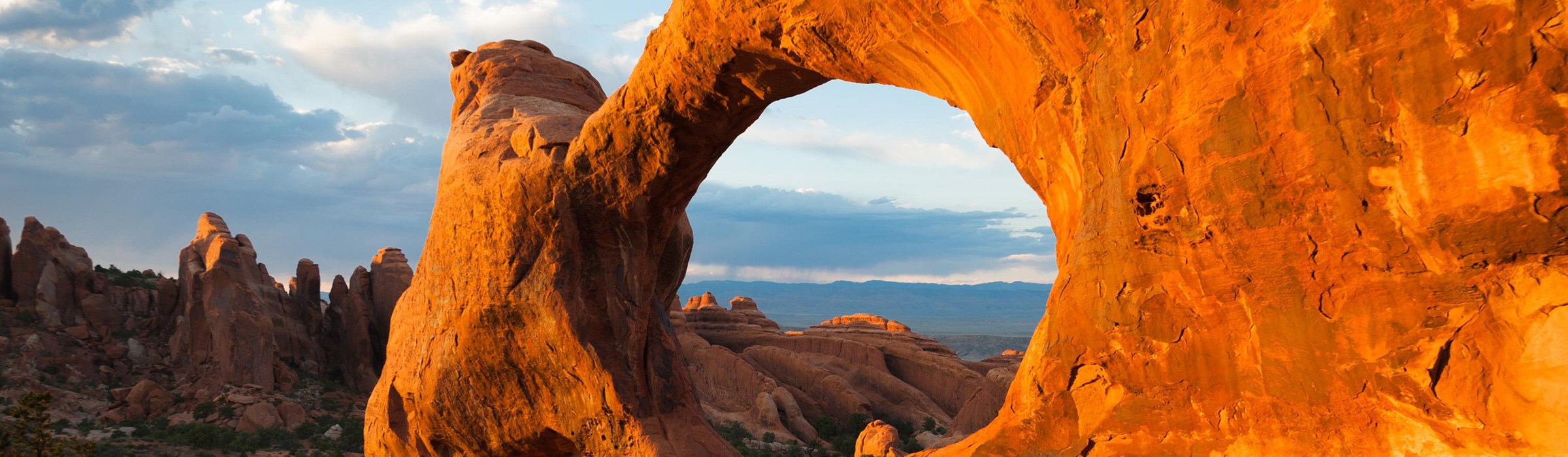
Arches National Park Utah |
|
 NPS photo | |
Water and ice, extreme temperatures, and underground salt movement are responsible for the sculptured rock scenery of Arches National Park. On clear, blue-sky days it is difficult to imagine such violent forces—or the 100 million years of erosion—that created this land boasting one of the world's greatest densities of natural arches. Over 2,000 cataloged arches range in size from a three-foot opening, the minimum considered an arch, to the longest. Landscape Arch, measuring 306 feet base to base. While several large arches are visible from the road, towering spires, pinnacles, and balanced rocks—perched atop seemingly inadequate bases—vie with the arches as scenic spectacles here.
Today new features are being formed as old ones are destroyed. Erosion and weathering work slowly but relentlessly, creating dynamic landforms that gradually change through time. Change sometimes occurs more dramatically. In 1991 a rock slab 60 feet long, 11 feet wide, and four feet thick fell from the underside of Landscape Arch, leaving behind an even thinner ribbon of rock. Delicate Arch, an isolated remnant of a bygone fin, stands on the brink of a canyon, with the dramatic La Sal Mountains as backdrop.
Native Americans used this area for thousands of years. The Archaic peoples, and later ancestral Puebloan, Fremont, and Ute peoples, searched the arid desert for food animals, wild plant foods, and stone for tools and weapons. They also left evidence of their passing on a few pictograph and petroglyph panels. The first non-native explorers came looking for wealth in mineral forms. Ranchers found abundant grasses for cattle and sheep. Disabled Civil War veteran John Wesley Wolfe and his son Fred settled here in the late 1800s. A weathered log cabin, root cellar, and corral give evidence of the primitive ranch they operated for over 20 years. A visit to Wolfe Ranch is a walk into the past.
The Story Geologists Tell
The park lies atop an underground salt bed that is responsible for the arches, spires, balanced rocks, sandstone fins, and eroded monoliths of this mecca for sightseers. Thousands of feet thick in places, this salt bed was deposited across the Colorado Plateau 300 million years ago when a sea flowed into the region and eventually evaporated. Over millions of years, residue from floods, winds, and the oceans that came and went blanketed the salt bed. The debris was compressed as rock, at one time possibly a mile thick.
Salt under pressure is unstable, and the salt bed lying below Arches was no match for the weight of this thick cover of rock. The salt layer shifted, buckled, liquefied, and repositioned itself, thrusting the rock layers upward as domes, and whole sections fell into the cavities.
Faults deep in the Earth made the surface even more unstable. You see the result of one 2,500-foot displacement, the Moab Fault, from the visitor center. Fault-caused vertical cracks later contributed to the development of arches. As the salt's subsurface shifting shaped the Earth, surface erosion stripped off younger rock layers. Except for isolated remnants, today's major formations are salmon-colored Entrada Sandstone, in which most arches form, and buff-colored Navajo Sandstone. They stand like a layer cake over most of the park. Over time water seeped into cracks, joints, and folds. Ice formed in the fissures, expanding and pressuring the rock, breaking off bits and pieces. Wind later cleaned out the loose particles, leaving a series of freestanding fins. Wind and water then attacked these fins until the cementing material in some gave way and chunks of rock tumbled out. Many of these damaged fins collapsed. Others, harder and better balanced, survived despite missing sections. These became the famous arches. Pothole arches are formed by chemical weathering as water collects in natural depressions and then eventually cuts through to the layer below. This is Arches National Park's geologic story—probably. The evidence is largely circumstantial.
Much More Life Than Meets the Eye
Park Plants and Wildlife
Pinyon and gnarled juniper trees add a splash of green contrast to the
red sandstone terrain. When conditions are just right, wildflowers bloom
profusely from April to July. Most mammals are active at night, but you
might see mule deer, kit foxes, or more often jackrabbits and
cottontails, kangaroo rats and other rodents, and small reptiles. Flocks
of blue pinyon jays chatter in tree tops. Migratory birds like mountain
bluebirds and residents like golden eagles are seen by careful
observers.
Protect Desert Life By Staying On Trails
Desert soils may appear barren, but they teem with living organisms that
bind loose, fragile soils together so they can support plant and animal
life. These organism-rich soils are a critical part of the ecosystem in
canyon country. Called "biological soils crusts," they prevent erosion,
absorb water, and provide vita nutrients to plants. This community of
cyanobacteria, lichen, algae, and fungi grows extremely slowly. A
single footstep can destroy hundreds of years of growth.
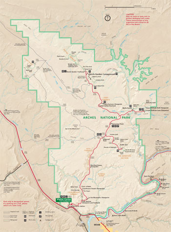 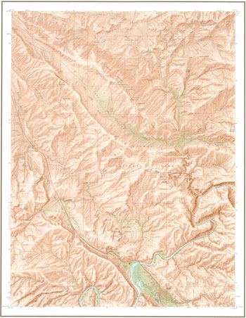 (click for larger maps) |
Exploring Arches
Arches National Park is a great family park where you can walk to many features. You can see much from a car, but the special aura of time, silence, and scale may elude you.
Stop at the visitor center for advice. Watch the orientation film, see the exhibits, and browse the publications, maps, and other sales items. A self-guiding audio tour is available. Ranger programs are offered seasonally. For more information check www.nps.gov/arch or ask at the visitor center.
The park has no food or lodging facilities. Moab, just south of the park, offers full visitor services. Devils Garden Campground, open all year, has 52 sites, water, and flush toilets. Two group sites (tents only, no RVs) are for groups of 11 or more. Reservations for individual sites and both group sites must be made at least six months in advance. Park staff cannot make reservations for you and cannot tell you what dates are available. For details on how to reserve sites, visit www.nps.gov/arch or call the park information line.
For Your Safety Both climate and landscape at Arches pose special problems for your safety and convenience. Summer daytime temperatures can reach 110°F (43°C). Heat and dehydration can be fatal. Carry at least one gallon (four liters) of water per person per day.
Sandstone is dangerous—it crumbles and breaks easily. It is easier to climb up than down; don't get stranded.
Driving Park roads are narrow and winding. Don't stop in the road; sightsee at viewpoints. Watch for pedestrians and bicyclists. Keep a safe passing distance (at least 3 ft/1 m). Stay on designated roads.
Bicycles Ride single file and only on designated roads; do not ride on trails or in backcountry.
Accessibility We strive to make our facilities, services, and programs accessible to all; call or check our website.
Regulations All federal and state laws are strictly enforced. • Federal law protects animals, plants, rocks, and other natural or historic features. • Do not scratch or carve rock. • Do not forage for firewood. Bring fuel (grills provided) or bring a stove. • Carry out all trash, even cigarette butts. • No hunting. • Get information and free rock climbing and canyoneering permits online or at the visitor center. • Do not walk or climb on arches.
Firearms For regulations check the park website.
Pets are allowed on park roads, in parking lots, or in your campsite but must be leashed at all times. Pets are not permitted on or off trails, in the backcountry, or in buildings. Pets left unattended in vehicles on hot days can quickly die from heat exhaustion.
Backcountry Use Backcountry overnight hikers must get permits at the visitor center. The backcountry has no designated trails or campsites. Use low-impact camping techniques. Carry all your water. • Fires are prohibited.
Trail distances are roundtrip unless otherwise noted. Trails are listed from south to north.
| Trail | Length | Description |
| Park Avenue (one way) | 1.0 mi/1.6 km | Moderate; short hill leads to smooth rock canyon bottom; tall walls, balanced rocks. |
| Balanced Rock | 0.3 mi/0.5 km | Easy walk around the base of Balanced Rock. |
| Windows Trail | 1.0 mi/1.6 km | Easy trail to North and South Windows and Turret Arch; 0.7 mi/1.1 km. Alternate return with primitive trail is slightly longer and more difficult. |
| Double Arch | 0.5 mi/0.8 km | Easy trail through some loose sand; spectacular arch. |
| Delicate Arch | 3.0 mi/4.8 km | Difficult trail with elevation gain of 480 ft/146m; no shade—take at least one quart of water per person. Open slickrock with some exposure to heights. |
| Delicate Arch Viewpoints | Distant views of Delicate Arch. | |
| Lower Viewpoint | 100 yds/91 m | Easy walk. |
| Upper Viewpoint | 0.5 mi/0.8 km | Moderately difficult, rocky uphill route. |
| Sand Dune Arch | 0.3 mi/0.5 km | Easy trail that is great for kids! |
| Broken Arch | 1.3 mi/2.1 km | Easy trail across open grassland. |
| Skyline Arch | 0.4 mi/0.6 km | Easy walk over rocks to closer view of arch. |
| Devils Garden Trail | 7.2 mi/11.6 km | Difficult. Longest of the trails. Includes Double O Arch, Landscape Arch, and primitive trail. |
| Landscape Arch | 1.6 mi/2 km | Moderately easy with some elevation gain; gravel surface. Short side trips to Tunnel and Pine Tree arches. |
| Double O Arch | 4.2 mi/6.8 km | Difficult with many short elevation changes, rocky footing, some exposure to heights. Short side trips to Navajo and Partition arches. |
| Primitive trail from Double O Arch to Landscape Arch | 2.2 mi/3.5 km | Difficult route through fins; short section of smooth slickrock; slippery when wet. Side trip to Private Arch. |
| Tower Arch | 3.4 mi/5.5 km | Moderately difficult in remote section of Klondike Bluffs. Some sand and elevation changes. |
Source: NPS Brochure (2015)
|
Establishment
Arches National Park — November 12, 1971 |
For More Information Please Visit The  OFFICIAL NPS WEBSITE |
Documents
2022 Pilot Timed-Entry Visitor Experience Survey Technical Report: Arches National Park (Wayne Freimund and Iree Wheeler, April 14, 2023)
An Administrative History of Arches National Park (David E. Purcell, April 30, 2019)
An Archeological Survey of the Northeast Portion of Arches National Park (Michael S. Berry, extract from Antiquities Section Selected Papers, Vol. 1 No. 3, June 1975, ©Utah State Historical Society)
Annotated Checklist of Vascular Flora, Arches National Park NPS Natural Resource Technical Report NPS/NCPN/NRTR-2009/220 (Walter Fertig, Sarah Topp and Mary Moran, June 2009)
Arches Alternative Transportation System and Congestion Management Study, Final Feasibility Study — Volume I (September 2012)
Arches Alternative Transportation System and Congestion Management Study, Final Feasibility Study — Volume II: Appendices (September 2012)
Arches Alternative Transportation System and Congestion Management Study, Final Feasibility Study — Volume III: Implementation Plan (September 2012)
Arches National Park Visitor Use, Access, and Experience Stud — Final Report (©RSG, November 2020)
Biological and Hydrological Surveys of Springs Along the Colorado River, Utah and Arizona: Surveys of Springs in the Colorado River Drainage in Arches National Park, Canyonlands National Park, Glen Canyon National Recreation Area, and Grand Canyon National Park — Part I Final Report (John R. Spence, February 2004)
Biological and Hydrological Surveys of Springs Along the Colorado River, Utah and Arizona: Surveys of Springs in the Colorado River Drainage in Arches National Park, Canyonlands National Park, Glen Canyon National Recreation Area, and Grand Canyon National Park — Part II - Appendices (A1-A5) Final Report (John R. Spence, February 2004)
Biological and Hydrological Surveys of Springs Along the Colorado River, Utah and Arizona: Surveys of Springs in the Colorado River Drainage in Arches National Park, Canyonlands National Park, Glen Canyon National Recreation Area, and Grand Canyon National Park — Part II - Appendices (A6) Final Report (John R. Spence, February 2004)
Biological and Hydrological Surveys of Springs Along the Colorado River, Utah and Arizona: Surveys of Springs in the Colorado River Drainage in Arches National Park, Canyonlands National Park, Glen Canyon National Recreation Area, and Grand Canyon National Park — Part II - Appendices (A7-A9) Final Report (John R. Spence, February 2004)
Delineation of Floodplains for the Unnamed Wash in Moab Canyon, Arches National Park, Utah NPS Technical Report NPS/NRWRD/NRTR-90/03 (William B. Reed, October 1990)
Dinosaur tracks from the Cedar Mountain Formation (Lower Cretaceous), Arches National Park, Utah (2004)
Draft Visitor Access and Experience Plan and Environmental Assessment, Arches National Park (October 2024)
Ethnographic Overview and Assessment for Arches National Park Fina Report (Richard Stoffle, Evelyn Pickering, Katherine Brooks, Christopher Sittler and Kathleen Van Vlack, June 2016)
Evaluation of Hanging-Garden Endemic-Plant Monitoring at Southeast Utah Group National Parks, 2013-2020 NPS Natural Resource Report NPS/NCPN/NRR-2022/2473 (Rebecca Weissinger, October 2022)
Fire and Fuels Management Plan (June 2005)
Foundation Document, Arches National Park, Utah (August 2013)
Foundation Document Overview, Arches National Park, Utah (August 2013)
Fourteen Years of Springflow Data at Arches National Park NPS Natural Resource Report NPS/NCPN/NRR-2015/1018 (Rebecca Weissinger and Mary Moran, September 2015)
General Management Plan/Development Concept Plan/Environmental Assessment, Arches National Park, Utah (January 1989)
Geologic Resource Evaluation Report, Arches National Park NPS Natural Resource Report NPS/NRPC/GRD/NRR-2004/005 (J. Graham, November 2004)
Historic Resource Study, Canyonlands National Park, Arches National Park and Natural Bridges National Monument (Western Historical Studies, Inc., Steven F. Mehls and Carol Drake Mehls, July 15, 1986)
Historic Structures Report: Wolfe Ranch (James R. McDonald Architects, October 1999)
Impacts of Visitor Spending on the Local Economy: Arches National Park, 2003 (Daniel J. Stynes and Ya-Yen Sun, January 2005)
Junior Ranger Adventure Guide, Arches National Park (Date Unknown; for reference purposes only)
National Register of Historic Places Nomination Forms
Arches National Park Multiple Resource (Steven F. Mehls and Carol Drake Mehls, February 15, 1988)
Courthouse Wash Pictographs (David B. Loope, May 28, 1974)
Julien Inscription Panel (S.F. Mehls, September 11, 1986)
Old Spanish Trail (S.F. Mehls, September 12, 1986)
Ringhoffer Inscription (S.F. Mehls, September 9, 1986)
Rock House / Custodian's Residence (S.F. Mehls, September 13, 1986)
Turnbow Cabin (Wolfe Ranch) (David B. Loope, May 28, 1974)
Newsletter: Visitor Access and Experience Planning: Arches National Park (2023)
Newsletter: Draft Visitor Access and Experience Plan/Environmental Assessment: Arches National Park (October 2024)
Paleontological Survey, Arches National Park NPS Technical Report NPS/NRGRD/GRDTR-05/01 (Brooke A. Swanson, Vincent L. Santucci, Scott K. Madsen, Ann S. Elder and Jason P. Kenworthy, September 2005)
Park Newspaper: 1999-2000 • 2003 • 2006 (No. 1) • 2006 (No. 2) • 2007 • 2009 • 2010 • 2011 • 2012 • 2013 • 2014 • 2015 • 2016 • 2017 • 2018 • 2019 • 2021 (Vol. 1) • 2021 (Vol. 2) • 2022 (Vol. 1) • 2023 (Vol. 1)
Pilot Timed Entry System at Arches National Park in 2022 NPS Natural Resource Data Series NPS/NRSS/NRDS-2022/2297386 (Amy Tendick, Caleb Meyer and Zachary D. Miller, March 2023)
Soil Survey of Arches National Park, Utah (2011)
Superintendent's Annual Reports (1941-2006, incomplete)
Surficial Geologic Map of The Loop and Druid Arch Quadrangles, Canyonlands National Park, Utah USGS Miscellaneous Field Studies Map: 2411 (2002)
The Geologic Story of Arches National Park (HTML edition) USGS Bulletin 1393 (S.W. Lohman, 1975)
Topographic Map: Arches National Park, UT Scale: 1:50,000 (USGS, 1977)
Water quality and quantity of selected springs and seeps along the Colorado River corridor, Utah and Arizona: Arches National Park, Canyonlands National Park, Glen Canyon National Recreation Area, and Grand Canyon National Park, 1997-98 USGS Open-File Report 2003-496 (2003)
Water Quality Data Analysis and Interpretation for Spring Monitoring Sites, Southeast Utah Group NPS Technical Report NPS/NRWRD/NRTR-96/77 (Barry A. Long and Rebecca A. Smith, August 1996)
Vascular Plant Species Discoveries in the Northern Colorado Plateau Network: Update for 2008-2011 NPS Natural Resource Technical Report NPS/NCPN/NRTR-2012/582 (Walter Fertig, Sarah Topp, Mary Moran, Terri Hildebrand, Jeff Ott and Derrick Zobell, May 2012)
Visitor Center and Park Entry Road Realignment Environmental Assessment, Arches National Park (Foster Wheeler Environmental Corporation, April 2002)
arch/index.htm
Last Updated: 14-Mar-2025