|
Assateague Island National Seashore Maryland, Virginia |
|
 NPS photo | |
BARRIER ISLANDS ARE AMONG THE MOST DYNAMIC LANDFORMS ON EARTH. FROM OCEAN TO BAY, ASSATEAGUE ISLAND IS DEFINED BY CHANGE.
The rhythms of tides and seasons shape the island. The smallest gust of wind or gentlest of waves moves sand in a ceaseless rearrangement of island terrain. While summer waves and longshore currents may build a wide beach, most of the year sand is scoured from the shore and moved southward leaving a narrow, steep shoreline. Storms can create inlets or fill them in. They can cut away dunes and wash sand across the island. The retreating dunes mark the island's westward movement. New habitats are created—old ones are reinvented. Plants and animals shift and adapt in counterpoint to these changes. On Assateague Island, nature's rhythmic processes are a brilliant display.
COASTAL BAYS Chincoteague Bay and two smaller bays separate Assateague from the mainland. They provide an environment rich in aquatic life and vital to ocean ecosystems. The warm, shallow waters create a productive nursery for mussels, crabs, clams, terrapin, and fish. Twice a day, tides rejuvenate these areas and ferry aquatic animals out to the ocean or into the relative safety of the bays.
Just beneath the bays' surface, in the shadowy world of the seagrass meadows, diverse marine life thrives. Blue crabs molt, hidden in the grasses. Young fish find refuge from predators. Seahorses and pipefish, vulnerable in open water, depend on grasses for anchorage and safe haven. Mud-loving creatures cluster around roots. These are the secret gardens of the coastal bays.
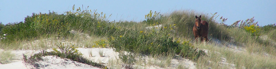
SALT MARSH Once considered worthless, salt marshes are incredibly valuable areas. They are complex ecosystems defined by the constant ebb and flow of salt water. Tides transport nutrients into the marsh and detritus {decaying plants and animals) out into the bay. Scavengers, like snails, amphipods, and fiddler crabs, feed on detritus. They in turn are food for high tide visitors to the salt marsh like fish and crabs. When the tide is out, a banquet is exposed in the mudflats where birds feast on the small creatures that inhabit this transitional area. Few plants can thrive in a salt marsh. Cordgrass, salt meadow hay, and saltwort are among those that can. These plants create shelter for willet and rail and hunting grounds for Northern harrier and raccoon. Horses can often be seen grazing on marsh grasses.
MARITIME FOREST The forest edge is bordered by a shrub thicket on both bay and ocean sides. This is another transition area between distinct communities. Greenbrier, highbush blueberry, and bayberry thrive here. Trees, stunted and sculpted by salt-laden winds, mingle with shrubs and vines. Guarded by this thicket, the maritime forest is sheltered from much of the wind and provides habitat for some of Assateague's other residents. While loblolly pine is the dominant tree, southern wax myrtle, American holly, and red cedar survive in the shaded understory. The forest is home to white-tailed and sika deer, raccoons, and birds like the yellow-rumped warbler and Eastern towhee. Predators like great horned owls and red fox hunt small mammals, birds, and reptiles in the woodland.
DUNES AND UPPER BEACH The dunes and upper beach are always in motion. Windblown sand and salt dictate the plant and animal life of this stark environment. Less salt-tolerant plants like beach heather and seaside goldenrod hide on the leeward side of dunes, sheltering the small but fierce dune wolf spider as it hunts its insect prey. Plants trap sand, elevate dunes, and form a malleable barrier against the assault of wind and water. Where overwash does occur, piping plovers and other birds find prized nesting habitat. The primary beach front dunes are dominated by American beach grass, with its extensive root system and ability to tolerate relentless exposure to the elements. Many creatures visit the beach, but ghost crabs enjoy a great view from oceanfront burrows.
OCEAN So visually compelling are the surf and ocean that it is easy to forget how much happens beneath the surface. Mole crabs, coquina clams, and small invertebrates thrive in the intertidal zone where crashing waves deliver food and render all homes temporary. Shorebirds dance away from the surf while attempting to dine on creatures concealed in the sand.
The ocean food web starts with phytoplankton. Most other marine life is dependent upon these tiny plants for survival. The oceans support more than half the species on earth, yet 95 percent of these waters remains unexplored, offering endless possibilities for discovery.
ABOUT YOUR VISIT
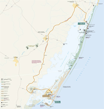 (click for larger map) |
ASSATEAGUE ISLAND NATIONAL SEASHORE is open year-round. Camping is allowed in designated areas only. Campers may not bring firewood from out of state. Firewood must be purchased locally. Assateague Island Visitor Center is open 9 am to 5 pm year-round except Thanksgiving Day and December 25. Here you can get information and see aquariums, a touch tank, exhibits, maps, and a film about the island's wild horses. You can register for camping and get permits for the Over Sand Vehicle (OSV) zone at the campground office on the island. Dates and hours vary for Toms Cove Visitor Center. Contact the park for information.
CHINCOTEAGUE NATIONAL WILDLIFE REFUGE, managed by t he U.S. Fish and Wildlife Service, is open year-round. The Herbert H. Bateman Educational and Administrative Center is open year-round except December 25 and January 1. Hours vary seasonally. Contact the refuge for information.
ASSATEAGUE STATE PARK'S beach and parking lot are open year-round, 9 am to sunset. Contact the park for camping information.
ACCESSIBILITY Visitor centers, restrooms, bookstores, and some trails are wheelchair-accessible. Service animals are welcome. Call each area for more specifics.
REGULATIONS Call or visit each area's website for regulations on firearms, pets, personal watercraft, and more.
SURF AND SEASHORE SAFETY
National Park Service lifeguards cover North Ocean Beach (Maryland) and
Toms Cove Beach (Virginia, in the National Wildlife Refuge) in summer
only. Assateague State Park also has lifeguards in summer. Mats and
floats, except U.S. Coast Guard-approved personal flotation devices, are
prohibited at all lifeguarded beaches. Surf conditions are posted in
multiple locations near the beach. Learn about rip currents (seaward
currents) and their danger at www.ripcurrents.noaa.gov. Never swim alone. Prevent
overexposure to sunlight with sunscreen or protective clothing. Biting
insects are abundant spring through autumn. Insect repellent and/or
protective clothing are recommended.
Assateague State Park
Maryland's only oceanfront state park has two miles of beach for swimming, surfing, and fishing. Lifeguarded areas are available Memorial Day through Labor Day. The campground is open late April through October. Campsites include fire rings, picnic tables, and bathhouses with warm showers. A small number of electric hookups are available. Reservations are recommended. Alcohol is prohibited in all areas of the state park. A park store is open seasonally, offering food and souvenirs. Pets are permitted, with restrictions, in designated areas. The marina/boat launch, located on the mainland side of the Verrazano Bridge, is a popular fishing and crabbing spot and features seasonal kayak rentals. Visit the Nature Center in the campground for live animal exhibits, arts and crafts, and family fun. Entrance fees apply. Assateague State Park offers something for everyone.
Assateague Island National Seashore
Explore the national seashore and discover the mysteries of a barrier island. Before traveling across the Verrazano Bridge to the Maryland end of the island, begin your visit at the Assateague Island Visitor Center. Watch a film about the wild horses. The visitor center also includes restrooms, a gift shop, exhibits, aquariums, and staff to provide information and orientation. Touch a sea snail or horseshoe crab. Ask at the information desk for a Junior Ranger booklet and have some family fun. Enjoy the park roads by bike. Observe wild horses feeding in the salt marsh. During summer, visit the Beach Hut for supplies and beverages and swim at the lifeguarded North Ocean Beach. Camping is available year-round and reservations are encouraged April 15 through October 15. Expect rustic conditions, vault toilets, and coldwater showers. Electric hookups are not provided. Pets are permitted in designated areas. Avid paddlers and hikers should not miss the backcountry camping experience. The Over Sand Vehicle (OSV) zone provides an adventurous getaway (permit required). Nature trails, beachcombing, and ranger-led programs will bring back childhood memories, while guided kayak tours and campfire programs will make new ones. Entrance fees apply.
Chincoteague National Wildlife Refuge
Originally established to protect migratory birds, the refuge today is a destination for birders, beachcombers, anglers, and outdoor enthusiasts. Careful management of freshwater pools and marshes provides ideal habitat and feeding areas for migratory waterfowl, shorebirds, and other wetland-dependent species. The refuge is a paradise for birders and photographers. Walk or bike the trails to catch a glimpse of the rare Delmarva Peninsula fox squirrel or the Chincoteague "ponies." Drive the Wildlife Loop around Snow Goose Pool between 3 pm and dusk. Expect Toms Cove Hook to be closed during the nesting season of the threatened piping plover. Visit the Refuge-operated Herbert H. Bateman Educational and Administrative Center and the National Seashore-operated Toms Cove Visitor Center for exhibits, programs, and assistance. There is no camping in the refuge, so check in the nearby community of Chincoteague. A lifeguarded beach is available Memorial Day to Labor Day. Pets are prohibited. Entrance fees apply.
Source: NPS Brochure (2014)
|
Establishment Assateague Island National Seashore — September 21, 1965 |
For More Information Please Visit The  OFFICIAL NPS WEBSITE |
Documents
A Comparison of Methods for Monitoring Epiphytes of Eelgrass (Zostera marina L.), Assateague Island National Seashore, Maryland and Virginia NPS Technical Report NPS/NRWRD/NRTR-2003/317 (Chris Lea, Rebecca L. Pratt, Elden W. Hawkes, Jr., Alejandro E. Almario and Jim Tilmant, August 2003)
A Photo Point Monitoring System for the Assateague National Seashore (Terry Bashore, Shauneen Giudice, Chris Pagan, Herb Thompson and Gary Taylor, December 1999)
Atlantic National Seashores in Peril: The Threats of Climate Disruption (Stephen Saunders, Tom Easley, Dan Findlay and Kathryn Durdy, ©The Rocky Mountain Climate Organization and Natural Resources Defense Council, August 2012, all rights reserved)
Assateague Beach Coast Guard Station, Station House, Garage, and Boat House Historic Structure Report, Assateague Island National Seashore (Maureen K. Phillips, 2007)
Assateague Island National Seashore: An Administrative History (HTML edition) (Barry Mackintosh, 1982)
Assateague Island National Seashore: NPS Handbook #106 (1980)
Assateague Island National Seashore Water Quality Monitoring 1987-1990, Data Summary and Report NPS Technical Report NPS/NRWRD/NRTR-91/06 (November 1991)
Assessment of the Effects of Feral Horses, Sika Deer and White-Tailed Deer on Assateague Island's Forst and Shrub Habitats Final Report (Mark Sturm, May 2007)
Atlas of Environmental Dynamics: Assateague Island National Seashore Natural Resource Report No. 11 (Robert Dolan, Bruce Hayden and Jeffrey Heywood, October 1977)
Coastal Vulnerability Assessment of Assateague Island National Seashore (ASIS) to Sea-Level Rise USGS Open-File Report 2004-1020 (2004)
Evaluating VDataum in Coastal Network Parks: Fire Island National Seashore, Gateway National Recreation Area, and Assateague Island National Seashore NPS Natural Resource Report NPS/NCBN/NRR-2016/1148 (David Ullman, Amanda Babson and Michael Bradley, March 2016)
Fire Control Handbook, Assateague Island National Seashore (July 25, 1968)
Fire Management Plan for Assateague Island National Seashore (September 18, 1985)
Foundation Document, Assateague Island National Seashore, Maryland-Virginia (March 2018)
Foundation Document Overview, Assateague Island National Seashore, Maryland and Virginia (December 2017)
General Background Study and Historical Base Map, Assateague Island National Seashore, Maryland-Virginia (Edwin C. Bearss, December 18, 1968)
Geologic Resources Inventory Report, Assateague Island National Seashore NPS Natural Resource Report NPS/NRPC/GRD/NRR-2013/708 (C. Schupp, August 2013)
Historic Context Study of Waterfowl Hunting Camps and Related Properties within Assateague Island National Seashore, Maryland and Virginia (Ralph E. Eshelman and Patricia A. Russell, July 21, 2004)
Historic Structure Report: Assateague Beach Coast Guard Station, Station House, Garage, and Boathouse, Assateague Island National Seashore, Assateague, Virginia Draft (Maureen K. Phillip, September 2000)
Horses of Assateague Island: Population and Habitat Viability Assessment Workshop Final Report (C. Zimmerman, M. Sturm, J. Ballou and K. Traylor-Holzer, eds., 2006, ©IUCN/SSC Conservation Breeding Specialist Group)
Junior Ranger, Assateague Island National Seashore (2017; for reference purposes only)
Long-Range Interpretive Plan, Assateague Island National Seashore (2002)
Management of Wild Horses by Fertility Control: the Assateague Experience NPS Scientific Monograph NPS/NRASIS/NRSM-95/26 (Jay F. Kirkpatrick, 1995)
Marine Animal Strandings: 2002 • 2003 • 2004-2007 • 2008-2009 • 2010-2023
Mosquitos at Assateague Island National Seashore (July 9, 1991)
Natural Resource Condition Assessment, Assateague Island National Seashore, Maryland, Virginia NPS Natural Resource Report NPS/ASIS/NRR-2011/405 (Tim Carruthers, Kris Beckert, Bill Dennison, Jane Thomas, Tracey Saxby, Mike Williams, Tom Fisher, Jack Kumer, Courtney Schupp, Brian Sturgis and Carl Zimmerman, June 2011)
Natural Resources Inventory and Monitoring Program Analysis, Assateague Island National Seashore (Andrea Jauck Chynoweth and Gordon Cooper Olson, October 1990)
Northeast Coastal and Barrier Network Geomorphological Monitoring Protocol: Part I—Ocean Shoreline Position, Version 2 NPS Natural Resource Report NPS/NCBN/NRR-2022/2415 (Norbert P. Psuty, Mark Duffy, Dennis E. Skidds, Tanya M. Silveira, Andrea Habeck, Katherine Ames and Glenn Liu, June 2022)
Oil Spill Risk Assessment for Assateague Island (Amuel Kennedy, Andrew Ristvey, Jessica Lankford and Marilyn Ailes, December 1991)
Overview of Climate Change Adaptation Needs, Opportunities and Issues: Northeast Region Coastal National Parks NPS Natural Resource Report NPS/NER/NRR-2014/789 (Amanda L. Babson, April 2014)
Park Newspaper (Visitor's Guide): Summer 2000
Proceedings of the 1991 Assateague Island Science Conference Sheraton Ocean City Resort and Conference Center, Ocean City, Maryland, October 28-29, 1991 (1992)
Radio Manual: Assateague Island National Seashore (May 1972)
Resource Briefs
George Washington and the Barrier Island Sheep (October 2015)
Changing Landscapes are a Reality (undated)
Feral Horse Management at Assateague Island National Seashore (undated)
Horse (Equus caballus) (April 2013)
Piping Plover (Charadrius melodus) (September 2012)
Seabeach Amaranth (Amaranthus pumilus) (March 2015)
Use of Submerged Aquatic Vegetation Habitat Requirements as Targets for Water Quality in Maryland and Virginia Coastal Bays — Assateague Island National Seashore, Maryland and Virginia NPS Technical Report NPS/NRWRD/NRTR-2003/316 (Chris Lea, Rebecca L. Pratt, Elden W. Hawkes, Jr. and Alejandro E. Almario, August 2003)
USGS, NPS, and NASA Investigate Horse-Grazing Impacts on Assateague Island Dunes Using Airborne Lidar Surveys USGS Open-File Report 2001-382 (2001)
Water Quality Overview of Maryland Coastal Bays (Date Unknown)
A Very Special Place (1994)
asis/index.htm
Last Updated: 01-Jan-2025