|
Bandelier
Administrative History |

|
CHAPTER 4:
A SHOW PLACE FOR THE AMERICAN TOURIST
When the Park Service assumed responsibility for Bandelier National Monument in 1932, the development of visitor-use facilities played a significant role. Two major periods of development defined Bandelier. The initial phase, during which the major administrative and visitor-use facilities were constructed, lasted from 1933 until the Civilian Conservation Corp (CCC) camp closed in 1941. The second period began with the Mission 66 program for Bandelier, which to led to major construction during the 1960s. In the 1980s, planning for the physical plant at the monument remained under the influence of the Mission 66 plan.
The three master plans designed for Bandelier revealed the evolution of Park Service attitudes towards development and accommodation of visitors. The initial plan, dating from 1934, was an unrestricted program of development. Its primary focus was to create facilities that allowed the monument to become an integral part of the southwestern national monuments group. Centered around the building of an entrance road into the Frijoles Canyon, the plan created a physical plant which made the site into a pre-eminent tourist attraction.
The master plan of 1953, revised under the auspices of the Mission 66 program, sought to alleviate the impact of the Los Alamos community upon the monument. Local residents came to see Bandelier as a "city park," causing serious overcrowding on the canyon floor. The master plan was a belated response to existing conditions, designed to address the conditions of the 1950s. Its emphasis on acquisition and development revealed a preoccupation with providing a buffer zone for the resources of the monument. Visitation at the site, however, quickly outgrew this plan.
After being caught short during the 1950s and early 1960s, Park Service planners tried to anticipate growth before it occurred. The master plan of 1977, in the works for a decade before its approval, planned for an expected increase in visitation. Confronted with the imminent opening of the Cochiti Dam recreation facility, Park Service planners took preventative action. Rather than wait for the impact, as they had in 1940s, NPS officials created a plan to facilitate what they expected to be the impact on the monument.
The Park Service and the powerful environmental community clashed over the proposal as the development ran afoul of another NPS program—the legally mandated evaluation of larger-than-5000-acre roadless areas for wilderness status. Wilderness areas were highly desirable to the environmental constituency. When the NPS recommended no wilderness for Bandelier, local and national organizations attacked the agency, claiming its stance would cause the degradation of the Bandelier back country. Although at the time the proposals seemed antithetical, in reality careful management made development of the facilities at the park and wilderness preservation into complimentary objectives.
Ironically, by the late 1980s, the expected growth of the Cochiti Lake region, the catalyst for the controversy, had not occurred. In 1986, the implementation of the proposals that exasperated local and regional environmental groups appeared to be a decade in the future. The Park Service took a more cautious approach to future plans of accommodating visitors at Bandelier. Agency focus shifted from trying to entice visitors to the site to providing visitors that arrived with a quality experience.
At Bandelier, the Park Service did not inherit a physical plant from the Forest Service. Although the concessioner's buildings were adequate, if ramshackle, there was little else in Frijoles Canyon. A small, dilapidated ranger cabin, with a telephone line that hooked into the network of the Forest Service, comprised the extent of Forest Service improvements in the canyon. The only access to the canyon was via a steep trail, preventing the sedentary, the infirm, and the old from visiting the main canyon ruins. To make Bandelier fulfill Frank Pinkley's dream of an entry point into the southwestern national monument group required extensive development.
After the Park Service assumed control at Bandelier, Frank Pinkley began to press for the construction of a physical plant. The only facilities in the monument belonged to the concessioners. Pinkley needed some place to base his operation. Although George and Evelyn Frey ran the Frijoles Canyon Lodge, Pinkley found their facilities inappropriate. From his perspective, the lodge area was too close to Tyuonyi, the community house ruins. The whole canyon floor looked too much like a homestead to Pinkley, with fruit trees, a large garden, chickens and ducks in the canyon, and cattle grazing on the south mesa.
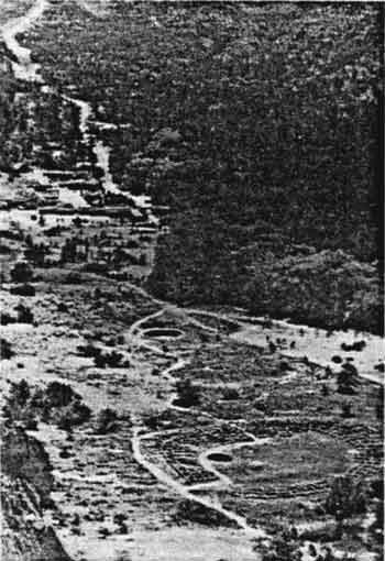
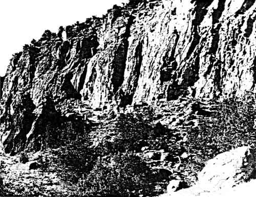 Before the coming of the CCC camp, the few trails in the monument discourage travelers who wanted to inspect the ruins. This photograph of the area including the restored Talus House reveals the condition of the trails in the park prior to 1933. |
Pinkley envisioned Bandelier as a prime attraction in the southwestern national monument group. More importantly, he saw it as the mouth of a funnel that would bring visitors to the other southwestern national monuments. As such, the monument required substantial development, the cornerstone of which was a road to the floor of Frijoles Canyon. Automobile accessibility would increase visitation dramatically, giving the agency justification for requesting substantial development funding.
For development purposes, the Park Service acquired Bandelier at precisely the right moment. It came into the Park System in 1932, ahead of the rash of park areas that Executive Order 6166, Franklin D. Roosevelt's measure to streamline the Federal bureaucracy, transferred to the agency. By the time New Deal programs, such as the Federal Emergency Relief Administration (FERA), were established, the Park Service, and particularly Pinkley, had specific plans for Bandelier. The Emergency Conservation Work (ECW) program of the Civilian Conservation Corp (CCC) gave the Park Service access to the necessary funding and work power to build administrative and visitor facilities from scratch. The Federal programs supplied funding and labor for the developments of the 1930s.
The most important feature of the development program was the construction of a road into Frijoles Canyon. Without a road to the canyon bottom, Bandelier would remain inaccessible. Although Forest Service officials opposed the idea of a road until the end of the 1920s, late in their tenure, they explored construction possibilities. The threat of local opposition thwarted any plans that developed. [1]
With his vision of Bandelier as a preeminent attraction among the southwestern monuments, Frank Pinkley advocated the construction of the road even before the Park Service assumed jurisdiction of the area. He weathered the opposition of a cadre of Santa Fe residents, to whom he referred as "mud-hut nuts," arguing that the road was a necessary improvement for a park area so close to an important tourist center. "We can't refuse 15,000 visitors admission" he wrote Horace Albright on October 8, 1932, "just because the Spanish didn't use automobiles 300 years ago: it just doesn't make sense." [2]
According to Jesse Nusbaum, it was not only Pinkley's "mud-hut nuts" who opposed the project. Much of the Santa Fe community, including prominent citizens such as Bronson Cutting, the owner of the New Mexican, resisted the idea of a road into the canyon. The Park Service presence was a feature in the volatile political climate of northern New Mexico, and Nusbaum worried that a proposal for a road would create new opposition. As a long-time resident of Santa Fe, his "firm conviction" was that the NPS should wait until there was a permanent ranger in Frijoles Canyon before it proceeded with the road. [3]
Despite resistance in Santa Fe, the NPS decided the road was imperative. Advocating its construction was an easy way to differentiate NPS administration from that of the USFS. "It would be unfortunate, indeed," Acting Director Arthur E. Demaray responded to Nusbaum on November 18, 1932, "if we were to follow a no more vigorous policy [regarding construction of the road] than was practiced by the Forest Service." [4] The road to Frijoles Canyon became a pivotal issue. Without it Bandelier would remain no different than the other Forest Service national monuments. Remote and unimportant, like many of the other national monuments, it would serve little purpose for an agency interested in attracting visitors.
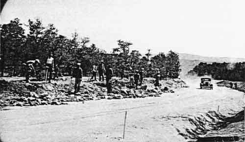 Building the road from the mesa to the canyon was the single most important innovation in Frank Pinkley's development plan for Bandelier. As soon as CCC workers completed the initial trail, the Park Service opened it to visitor travel. Meanwhile, as this photo shows, CCC men continued to improve the road. |
During the 1920s, Stephen T. Mather and Horace M. Albright developed the Park Service by providing visitor service and in the early 1930s, the agency closely adhered to their doctrine. Park Service inspections stressed the problems that existing conditions created. The lack of access impeded visitation. According to George Grant, a Park Service photographer who inspected and photographed Bandelier on October 20, 1932, the trail into the canyon was an "actual barrier" for all but the most vigorous travelers. The existing trail discouraged four of every five visitors who approached the park. Many looked over the edge at the trail and abandoned their plans to visit the canyon floor. "The visitor," Grant wrote, "must be able to get his car close to the points of interest." [5]
With a road to the canyon bottom, Bandelier could be as a popular as any park area in the Southwest. The Washington Office of the NPS favored the development of the park and discounted opposition; Demaray told Nusbaum that "the easiest way to get visitors to Bandelier is to build a good road." [6] "Looked at from the standpoint of keeping visitors out of a national monument," Pinkley wrote Hunter Clarkson, the proprietor of the Indian Detours guide service, "the present trail may be considered a complete success, although we could, by putting in a few more steep angles and digging some holes in the trail[,] cut the present four thousand visitors in half." [7] Pinkley's facetious tone indicated his position clearly. In 1933, there were few projects more important to his southwestern national monuments group than the road to Frijoles Canyon.
To mask his true objectives and combat local resistance, Pinkley initially presented the road as a service trail. He stressed the efficacy of the road in letters to CCC and ECW administrators. Without the road, building the structures he sought for the canyon verged on impossibility. It also provided him a convenient way to achieve his goals without arousing the rancor of those who opposed him.
There were a number of possible routes for roads into the canyon. National Park Service Historian Verne E. Chatelain visited Bandelier with George Frey, the concessioner, and looked at the options. The New Mexico state surveyor had laid out one possibility, which had steep grades and was visible from the canyon bottom. Park Service landscape architects did their own road survey. The route the agency proposed was longer, but its grades were less steep and according to Chatelain, the scar it left would be almost invisible from the canyon floor. [8] Despite the increased distance, a road that could not be seen from the canyon floor fit the philosophy of the Park Service. After a number of additional inspections, the longer, more scenic route was approved.
Construction began in November 1933, almost as soon as the CCC camp at the monument opened. On December 9, 1933, the first car went down the unfinished trail, carrying Mrs. Evelyn Frey and Walter G. Atwell, the Park Service engineer who oversaw the project. [9] The road, however, was far from complete. ECW regulations only permitted the construction of a truck trail twelve-feet wide with its funds. It took money from another New Deal agency, the Civil Works Authority (CWA) money and most of 1934 to complete the 22-foot wide trail to the canyon.
Other development projects started as soon as the CCC camp was staffed. As work began on the initial master plan, Pinkley submitted a list of projects that he believed were necessary at the park. After the road, the priorities were water and sewer systems, renovation of the ranger's cabin, and trails—on the valley floor, to the Frijoles falls, and to the Ceremonial Cave. Fencing to protect the Frijoles section from cattle that wandered over from the nearby Ramon Vigil grant was necessary, as well as some sort of boundary protection for the detached Otowi section. Construction on many of these began when the camp opened in November 1933. Pinkley also wanted money to repair the ruins and remove the Frey's fencing, barns and outbuildings. [10] The ECW appropriation, however, was too small to include his entire plan, and Pinkley was forced to wait until later enrollment periods.
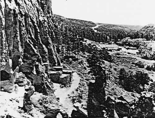 Frank Pinkley's program created facilities for visitor service at Bandelier. By early in 1934, the trail through the main ruins of Frijoles Canyon had been substantially improved. This photo of the trail shows the importance of capital improvements to the Park Service. The road from the mesa top, the most important development in preparing the monument for visitors, is visible, as are the temporary structures of the CCC camp. |
The major planning problem at Bandelier was to find adequate space in the canyon for all of the necessary facilities. Spontaneous development at the monument aggravated the situation. While the Office of Planning and Design drew up a master plan for Bandelier, ECW money allowed Pinkley to begin other projects.
The ECW programs made it advantageous to the NPS to begin as many projects as possible. Projects already underway received nearly automatic renewal at the beginning of a new enrollment period; new projects required the approval of ECW administrators. As a result, Pinkley began every project he could, and despite the efforts of Assistant Landscape Architect Jared Morse to keep track of everything, programs funded through the ECW often began when ECW money arrived. NPS architects and planners accepted these projects as established fact and worked such faits accompli into their long-term plans.
 The original Frijoles Canyon Lodge, pictured here, offered the only accommodations and refreshements in Frijoles Canyon prior to the coming of the Park Service. In 1907, Judge A. J. Abbott and his wife Ada Patton Abbott built the structure directly across the creek from Tyuonyi. When George and Evelyn Frey took over concessions in the monument in 1925, they improved it. In addition to the main cabin, there were a number of guest cabins located behind the structure. |
The location of the parking area and administration building became the most divisive issue that emerged from the planning process. According to the initial plans of the Engineering Branch, the Frey's hotel operation was to remain across Frijoles Creek, southwest of Tyuonyi. For protective reasons, Pinkley was committed to the concept of providing visitors with guided tours through the ruins. He thought his program gave the visitors better understanding of the site than did self-guided visits. The two perspectives were irreconcilable.
If the Park Service were to eliminate the possibility of self-guided visits at the monument, agency facilities had to provide the only approach to the ruins. As a result, Pinkley suggested that the agency locate a combination administration building and museum, along with a widened parking area, at the base of the new road. Such a development would compel visitors to make contact with Park Service personnel before reaching the ruins, a program with which Pinkley had great success at Casa Grande. It also meant that tourists would have to walk about one-quarter of a mile to the Tyuonyi ruins.
The Frey's development, however, presented a formidable problem for Pinkley. Its location threatened the proposed development. Besides the contemplated structures, Park Service plans called for a campground south of Frijoles Creek, with an auto trail that continued to the Frey's lodge. Frank A. Kittredge, the Chief Engineer of the agency, believed that the trail to the Frey lodge would allow visitors to circumvent the interpretation facilities of the agency. "No artificial obstacles . . . will long prevent the extension of the road [toward Tyuonyi]," Kittredge wrote Pinkley. "When the road is extended up the valley, then the parking area and museum will become merely a way-point and little used." [11] In Kittredge's opinion, the camp road to the lodge would become the primary road in the canyon and make the proposed development obsolete. "If placed in the lower end of the valley," he wrote, [the administrative offices and museum] "will be by-passed almost from the start." [12] This became a critical administrative issue. If Pinkley was to make Bandelier the entry point to the southwestern national monuments group, visitors had to understand that the Park Service was their host. The growth of the system he established in the Southwest depended upon the development of Bandelier. If the Freys answered the questions of visitors and provided them with water and shelter, it would defeat Pinkley's purpose. People would not see the relationship between Bandelier and his other monuments. Pinkley could not afford to let the Freys remain where they were.
Committed to controlled access to archeological sites, Pinkley envisioned the administration building as the permanent termination of vehicular access to the monument. If it was constructed as a portal to the ruins and "we make the parking ground the end of the journey and show the visitor he has arrived," Pinkley wrote, and "that here are the administration and museum buildings, . . . [and] the point of departure for guided trips," then visitors would stop. [13] They would realize that they were at the place from which to begin their tour and would not continue to the lodge unless they planned to stay there.
In Pinkley's mind, if the hotel interfered with the ability of the Park Service to manage the site, it would have to be moved. The Freys were subject to NPS jurisdiction, and they would have to accede to the agency's wishes. "If . . . we find we can't handle the visitors but that they are determined to by- pass us and go to the lodge," Pinkley announced to Kittredge, "I will then propose to move the lodge down to the administration area." [14] In Pinkley's view, concessioners were less important than presenting the ruins in a fashion that would ensure both protection of the site and a worthwhile experience for visitors. The Freys would have to accommodate the wishes of the agency.
From a technical standpoint, Kittredge and the engineering branch were laying long-term plans to preserve the agency's investment. They believed that the Park Service would continue to accommodate an increasingly sedentary public. Visitor service was the means through which the agency built its constituency. As long as the agency advocated that policy, Kittredge would offer plans that required little physical effort on the part of visitors.
Pinkley viewed the administration of archeological ruins in a more subtle fashion. More concerned with presentation and protection of the resource than the engineering branch, Pinkley drew a line at allowing the visitors so much leeway that his rangers could not fulfill their obligations. He felt that the quality of the experience at Bandelier would be preserved by keeping cars away from the ruins. "Almost all the visitors have heard of and seen pictures of the Ceremonial Cave; they want to see it above anything else in the canyon," Pinkley wrote in response to Kittredge's contentions. "Must we, therefore, build an automobile road up to it through the whole length of the canyon and deliver [visitors] there as soon as they arrive?" [15] Instead, by controlling access through a gateway, Pinkley felt that visitors would get a better grasp of the meaning of the Frijoles Canyon ruins. From his perspective, education of that kind was the chief obligation of the agency.
Pinkley's stance tempered the Mather-Albright visitor accommodation edict, and Pinkley received praise from those in the Park Service who believed site development went too far towards comfort. His rigid control over the southwestern national monument group made him an important factor in decisions concerning Bandelier. Moreover, his extensive experience in the Southwest gave him the authority to contradict agency engineers and planners.
In the end, most of Pinkley's ideas for Bandelier were implemented. With ECW labor and funding, the old lodge was torn down. The 99-year lease that the Freys made with the Forest Service in 1925 still bound the agency. Thus it had to replace the facilities it destroyed. The new Frijoles Canyon Lodge soon appeared within the administrative compound. Other than the campground road which led to the old lodge, additional roads beyond the main parking area were not built. Pinkley's ideas about controlled access served well at Bandelier. Park Service personnel continued to control access to the ruins, which remain insulated from the noise and traffic of modern life in the area.
According to agency plans, the main compound area was constructed in the canyon. Despite the restriction to 1500 square feet on construction of individual units, the compound ultimately included visitor facilities, the administrative offices, the new lodge, employee residences, picnic and campgrounds, and a maintenance area.
  |
| These two photos show the completed compound that the CCC constructed. In the top photo, the gateway by the administration building is blocked by posts. Note the CCC camp in the background. The bottom photo shows the relationship between the compound and Tyuonyi ruin. Note that the portal in the compound remained open at the time of this photo. At this time, visitors drove their vehicles into the portal, where a ranger greeted them. This practice was short-lived, for it violated the principal that Frank Pinkley insisted upon when he developed the first plan for the monument in the 1930: control of access to the ruins. |
The ECW project at Bandelier also constructed utility systems for the monument. An oil house and underground gasoline and oil storage tanks were added. In advance of the construction of a new telephone line to the monument, the NPS installed a telephone line to the administration building, residential, and utility areas. The old Forest Service line and the Frey's hotel line served in the interim.
Modern electrical and sewage systems were also part of the project. Workers constructed a power house near the utility area and ran power lines to the administration building, each of the residences, the maintenance and utility shops, and the lodge. A refuse burner made of reinforced concrete was located upon the north mesa, and two reinforced septic tanks, connected with 2150 lineal feet of service lines made of vitrified clay, handled sewage. [16] After June 1939, when the last of this work was completed, the monument had the physical plant and utility capabilities of a small city.
After the completion of the road to the canyon, providing water also posed a problem. Prior to the road, the Abbotts and the Freys got their drinking water from the stream. Yet the increase in the numbers of people living in the canyon, combined with the influx of auto tourists upon completion of the road, posed the danger of fouled water. With the arrival of the CCC camp, Pinkley had the enrollees run a pipeline from above the Ceremonial Cave to avoid the chance of contamination. Later, permanent water lines to the lodge, residential area, headquarters, and campground were built, and two water storage tanks, with 10,000- and 20,000-gallon capacities, were constructed. [17] With the completion of the project, water quality and pressure at Bandelier was better than anywhere else on the plateau.
When the CCC camp at Bandelier was disbanded in 1940, the physical plant in the canyon was complete. In seven years of concentrated effort, park planners designed the facilities and CCC enrollees carried out the massive building program that formed the basis of the physical plant at the monument in 1985. Made exclusively with indigenous materials and constructed in the style of the region, the stone masonry structures at Bandelier have acquired historic significance in their own right. In 1987, the Secretary of the Interior declared them National Historic Landmarks.
  |
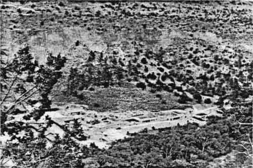
| These two photos of construction of the compound show the process of building the compound. The CCC buildings used stone from a quarry on the mesa-top and other indeginous materials. Construction was a labor intensive process that often employed more than 200 men. |
The physical plant that the agency built, however, was constructed to serve the needs of a remote park area. During the 1930s, there was no need to take into account local day use of the monument. The Pajarito Plateau had few residents and most made a living in ranching or farming. They had little need for the recreational facilities of Bandelier National Monument and little time to enjoy its cultural attributes. The coming of Manhattan Project, which developed the atomic bomb, and the growth of the town of Los Alamos changed Bandelier and the Pajarito Plateau forever.
During the development of the Los Alamos facility in the early 1940s, the military ran into stiff resistance from Custodian Art Thomas and the staff at Bandelier. When the secret facility at the old Los Alamos Ranch School began operations, Thomas visited the installation to offer his cooperation. He found barbed-wire gates in his way and the guards rudely rebuffed him. Surprised, he informed his superiors and left the camp alone. But Thomas knew that the access routes to the installation passed through the Otowi section of Bandelier. Moreover, he heard rumors that indicated the "army," local slang for the people in charge of the secret project, planned to build an extensive facility at Los Alamos. While Thomas had no desire to obstruct the war effort, he had obligations of his own and was determined to protect the monument.
But the U. S. Army, whose officers administered the installation, took an aggressive approach to its needs in the area. The U.S. Army Corps of Engineers made plans to develop the road through the detached Otowi section of Bandelier. By February 5, 1943, the contractor drilled one hundred holes twenty to thirty feet deep in order to dynamite cliffs adjacent to the Otowi section and widen the road.
When he found out what was going on, Thomas became incensed. The army intended to "shoot the whole cliff off in one blast," he reported. If it did, he could "not see how it can help creating a terrific scar and do great damage to the trees and vegetation below the hill." In Thomas's view, military plans would damage the Otowi section irreparably.
The implications of military behavior on the plateau posed a threat to the monument. Thomas pushed his superiors for some kind of agreement with the army. The status quo put the Park Service at a disadvantage, Thomas believed, and he "dislike[d] the idea of letting [the military] proceed and then coming around later wanting a permit for what they have already done." [18] He wanted a conference with the military officials to sort out decorum in the region.
Thomas had little success talking with the military. He began to visit the Otowi section every other day to keep an eye on its activities. His vigilance got Ray Bell, construction superintendent for the Sundt Construction Company, to pay closer attention to the desires of the Park Service. Rather than indiscriminately cutting through the monument, Bell ordered his trucks to use only one path through Otowi and promised to ensure that his men kept their warning fires under control. Thomas was not convinced and informed his superiors: "it goes without saying that the contractor is going to get things done as cheaply as he can and the fewer restrictions he has the more cheaply he'll get by . . . note that cooperation was promised, but it will probably take a good deal of watching to gain compliance." [19]
Thomas continued to watch "The Hill" suspiciously and his vigilance paid dividends. In October 1944, the U.S. Army Corp of Engineers began clearing a power line right-of-way through the northern tip of the Otowi section without Park Service permission. On one of his trips, Thomas discovered a fifty-foot wide clearing and two unauthorized buildings on monument land, as well as a surveying party setting up stakes to mark the location of line poles. Thomas immediately "shut the work down," threw the surveying party out of the monument, and ordered them to tell Colonel Whitney Ashbridge, the commander of the post, that the army had to consult the Park Service before beginning such projects. Thomas then contacted his superiors and waited for the showdown. In the meantime, he arranged for the Director of Region Three, M. R. Tillotson, and the Superintendent of the Southwestern National Monuments, Charles A. Richey, to inspect the area on October 19.
The ability of the military to disregard the presence of the Park Service astonished Tillotson and Richey. Major Frank W. Salfingere of Project "Y" told the men that all the clearing work had been done in one day. Tillotson also noted that the army did not plan to inform the Park Service even after completion. The Park Service men realized that military plans meant permanent use of monument lands—another issue that Salfingere did not bring up.
Park Service officials found themselves in a difficult position. The development at the old Los Alamos ranch was the greatest threat to the integrity of the monument that had ever occurred. Yet, the Park Service faced a secret war-time project about which it knew little. Park Service officials had no desire to impede the war effort in any way. Carrying out the mission of the agency and assisting the war effort seemingly became antithetical.
All Park Service officials wanted was an acknowledgement of their right to administer the monument by the rules of their agency. But used to the preeminence it enjoyed during wartime, the military pressed ahead relentlessly, ignoring protestations about its disregard for Park Service rules and regulations. Salfingere apologized for the unauthorized construction and told Tillotson that he would see what he could uncover. Later, Salfingere met with Park Service officials and claimed he could not find out who authorized the construction of the right-of- way. Tillotson was disgusted and later referred to this as "a continuation of the old army game of 'passing the buck'". After considerable pressure, Salfingere finally relented and agreed "that it might be possible" to keep the power line out of the monument.
Rather than battle the feisty Park Service people, the military took a new approach. The army real estate suboffice began a move to have the Army Corp of Engineers take over portions of the Otowi section for the project. [20] The area it wanted included the access road, Bayo Canyon, and Pueblo Canyon, the location of the Otowi ruins. According to rumors, the military planned to detonate explosives throughout the area.
Regional Director Tillotson refused to back down. He saw such development as gratuitous and noted in a confidential memo to NPS Director Newton B. Drury that experimental detonation near Otowi might irreparably damage the ruins. Tillotson strenuously opposed the project, although he realistically noted that because of the importance of the project, "we realize that our opposition might not carry much weight." [21]
Such stiff resistance from the Park Service forced the army to back down. The Corps of Engineers found a location outside monument boundaries for the power line. Salfingere promised Art Thomas that when the two sides agreed on road issues, the Corps of Engineers would apply for special use permits through the War Department to the Secretary of the Interior. The Corps of Engineers also abandoned its plans to acquire portions of the Otowi section.
Agency vigilance protected the Otowi section from indiscriminate destruction at the hands of the military. By asserting their position, Thomas and Regional Office officials forced Project "Y" to take into account the world that existed on the Pajarito Plateau before the arrival of the atomic age. While those in charge of the Los Alamos installation never became sensitive to cultural values, Park Service resistance meant that the military knew that there were other concerns on the Pajarito than its own.
Despite friction over the Otowi section, Park Service cooperation with the project was the rule rather than the exception. Whenever possible, the agency accommodated the needs of the project, particularly when officers at the installation followed the proper channels. The Park Service only asked for standard inter-departmental courtesy and respect for its own obligations.
After the Second World War, local use became an important factor in visitation at the monument. Frank Pinkley designed the physical plant for needs of the 1930s. The canyon area was limited, and its resources confined. There was a small parking area, and overnight guests and daytime users shared the combined picnic area and campground. But residents of Los Alamos began to see Bandelier as an outlet for their recreational needs. The staff at the monument had to address new forms of use.
The first indications of impending changes in visitor use occurred after the Second World War. Project "Y", the portion of the Manhattan Project for which the Los Alamos installation was created, was the catalyst for the explosion of the atomic bomb. The name "Los Alamos" became synonymous with atomic weaponry, and the wartime installation became permanent. The Los Alamos Scientific Laboratory became the major employer on the Pajarito Plateau. By 1950, the surrounding communities grew to a population of 14,000.
Local residents quickly developed a view of the monument that was different from what Park Service personnel envisioned when they designed the site. After a few initial trips to the ruins, area residents became far more interested in the picnic and campground areas than they were in the ruins. Day-use trips to Bandelier became prevalent. On weekends, locals picnicking near Frijoles Creek filled the campground.
The existence of Bandelier offered residents of Los Alamos a release from the stress of life during the Cold War. In the late 1940s and early 1950s, the United States and the Soviet Union engaged in a race to develop superior weapons. Los Alamos was the focus of American efforts. The pressure was overwhelming, and Los Alamos itself offered few opportunities to relax. Its residents turned to the serenity of Frijoles Canyon. Superintendent Fred Binnewies recalled that he could "feel them being renewed physically and mentally" during their visits. [22]
 Interpretation of the prehistory of the region has always been an important part of the responsibilities of the Park Service. The spectacular backdrop of Frijoles Canyon and the ruins it contains have intrigued generations of visitors. |
Visitation also increased exponentially at most Park Service area after the war. Serious management problems throughout the system were the result. Americans had more money, better mobility, and more leisure time. They flocked to see their national park system in droves. Park facilities were quickly overwhelmed and overcrowding became common. Conditions at many parks deteriorated so badly that author Bernard DeVoto suggested closing the national parks if they were not properly maintained.
Bandelier was among the parks where overcrowding became a problem. Visitation rose from 9,312 in 1945 to 45,524 in 1950. The combination of local use and visitors from all over the nation aggravated the problem of facilities at Bandelier. It faced an enlarged traditional constituency and the new local one. The facilities designed during the 1930s could not comfortably handle the new levels of visitation.
The larger numbers posed a different kind of problem at Bandelier than at many other parks. Locals and visitors engaged in competition for the use of limited space and facilities. People from all over the world wanted to see the ruins. Accommodations in the vicinity were scarce, and many visitors expected to camp at the monument. These visitors were the original constituency of the agency, the ones for whom Frank Pinkley built the facilities. They were forced to compete for limited campground space with picnickers from Los Alamos and White Rock, who wanted to use the shaded campground/picnic area next to the creek. The CCC development, constructed to fill the needs of an earlier era, quickly became inadequate.
The Park Service, however, was in a difficult situation. Frijoles Canyon was an extremely small area, and the concentration of facilities at the southeast end of the canyon made expansion in that direction impossible. The campground/picnic area bordered the canyon wall on one side and the creek on the other. Its northwestern most point was within 650 feet of Tyuonyi, leaving little room for expansion in that direction. Ruins and trails covered much of the remaining area. With limited space available and users already overwhelming the existing facilities, Frijoles Canyon was becoming a major management problem.
When appointed Director of the National Park Service in late 1951, Conrad L. Wirth initiated a program to revise existing master plans at all agency park areas. He had been an advocate of visitor-service developments since he became involved with the Park Service in the early 1930s. Wirth orchestrated the planning and execution of extensive developments, including the Mission 66 capital development program, during his thirteen years as agency director. [23] The impact of his programs on Bandelier ultimately changed the administration of the monument.
Park Service personnel began from scratch. The existing Bandelier master plan preceded the Second World War. The issues confronting park managers were no longer the same. By the early 1950s, Bandelier was overwhelmed. It had acquired many of the characteristics of a city park. Residents of nearby communities accounted for more than half the annual visits, an eventuality that Frank Pinkley and the others who designed the site in 1930s could not have foreseen. The facilities at Bandelier were not constructed to accommodate the conditions that came to exist at the monument. Recreational day use was simply not an issue during the 1930s. The new master plan had to address the realities of the moment. Planning for the future had to be delayed.
Recognizing the problems and getting something done about them were two completely different tasks. In 1952, Superintendent Fred W. Binnewies carved out a master plan that identified the minute size of the concentrated headquarters area and the overcrowding of the canyon floor as the two most important problems facing the monument. But there was little funding available for development until the advent of the Mission 66 program in 1956. Binnewies's program was approved and began to gather dust. [24]
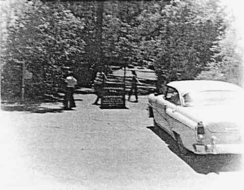 The photograph suggests the frustration of visitors who arrived at Bandelier only to find the campground full. The growth of visitation inspired the development of a campground on top of Frijoles Mesa. This converted the old area to day-use and allowed the Park Service to accommodate larger numbers of visitors. |
In 1955, Binnewies's successor, Superintendent Paul Judge, began to compile a prospectus for Mission 66 at Bandelier. Following the guidelines set out in the master plan of 1952, Judge began to look for ways to address the perennial problem at the monument: its "urbanization" and the consequent overcrowding of the canyon floor.
Judge's solution suggested ways to shift the focus of visitors to the monument away from Frijoles Canyon. He advocated bringing the portion of Frijoles Mesa between Highway 4 and the existing boundary into the monument, as well as terminating additional development within the Frijoles Canyon. He also proposed a contact and information station on Highway 4, near the Los Alamos "Y", as well as a development in the Otowi section that included a museum, campground, ranger station, and employee residence as an additional part of a "gradual pulling back." [25] Judge attempted to interest the public in more than the cultural resources of Frijoles Canyon.
Mid-level agency response was sympathetic to Judge's plan, but opinions differed on how to achieve his goals. Robert G. Hall, Acting Chief of the Branch of Design and Construction of the Western Office, concurred with the principal recommendations. He questioned the need for the dual development in the Otowi section and suggested changing the fee structure in order to discourage picnicking as a quick way to alleviate overcrowding in Frijoles Canyon. [26] Acting Regional Chief of Operations Jerome Miller believed that if camping were eliminated, overnight lodging in the Canyon could also be removed. Oscar T. Carlson, Superintendent of Mesa Verde, agreed, as did K. M. Saunders of the Regional Office, who wrote: "Bandelier should be used as an archeological area, not a playground." [27]
Agency executives were less impressed. Regional Director Hugh M. Miller passed the proposals to Director Wirth. Miller agreed with Hall that the Otowi contact station and museum ought to be combined in one unit, but he did not believe that any other improvements in the detached portion were necessary. Although he concurred with the proposed addition of the Frijoles Mesa area, he questioned the need for campgrounds atop the mesa. Instead of restricting camping in Frijoles Canyon, Miller endorsed Hall's proposal to change the fee structure in order to discourage picnicking. [28]
After the necessary revisions, Judge submitted the Mission 66 prospectus for approval. The document reflected Acting Regional Director Miller's beliefs as much as those of the superintendent. The prospectus offered fee adjustments and reservations as the means of controlling day-use in Frijoles Canyon, and the detached Otowi section was slated for development. The campground, however, would remain in the canyon.
The prospectus also included substantive development of the physical plant. Seven housing units were included in the program, providing living space at the monument for the families of the entire permanent staff. Judge also proposed additional housing for seasonal employees. Other programs for Frijoles Canyon included 17.9 miles of trails, a new telephone system, and boundary fencing on the north side of the monument. The total cost was projected at $510,000, of which $347,000 was earmarked for building new quarters. Improvements at Otowi were expected to cost another $450,200.
Mission 66 for Bandelier also proposed dramatic increases in the number of staff members employed at the monument. The permanent administrative and protective staff was to be increased from the four existing members in 1956 to nine by 1966, seasonal staff, from eight to fifteen. Two additional positions in the maintenance division and one on the road and trail crew were also included in the plan.
Judge erroneously believed that the Mission 66 program for Bandelier would solve the problems of the monument once and for all. After the completion of the program, Judge contemplated no more major development. If everything in the prospectus became reality, he believed that facilities at the monument would be capable of handling the projected increases in visitation well into the 1970s. [29]
On March 8, 1957, Associate Director E. T. Scoyen approved the document with one reservation. He recommended additional study of the camping/picnicking issue. Scoyen believed recreational uses at Bandelier ought to be provided only as a convenience for visitors. He requested a study to determine the feasibility of separating camping and picnicking facilities, as well as an assessment of the potential of lands outside the monument that might be developed into parks for local residents.
By far the most important consequence of the Mission 66 program at Bandelier was the acquisition of the Frijoles Mesa. The idea to acquire the mesa had occurred earlier, but the potential for capital development that Mission 66 inspired made the acquisition a necessity. The new area modified the original Mission 66 plan and gave Park Service officials a number of additional management options for the monument. By the early 1960s, Superintendent Judge and the regional planning staff envisioned the Frijoles Canyon as an area exclusively reserved for day-use. Agency officials believed that the completion of State Highway #4 through the Jemez Mountains, projected for 1965, would aggravate the eternal problem at Bandelier—the overcrowding of Frijoles Canyon.
The acquisition of the mesa provided additional space into which to expand and allowed the administration of the monument to rethink development plans. Judge codified all of the earlier objectives of the agency that had been passed over because of space limits in the monument. The new land allowed the old campground to be converted into a picnic area, furthering the day-use only ideal for Frijoles Canyon. Meanwhile, the Park Service sought to convert Mrs. Frey's lodge into a visitor center to handle the increased traffic.
The Frijoles Mesa tract allowed the Park Service to manage the historic structures in Frijoles Canyon as if they were a cultural resource. The structures built during the 1930s were unique, and unlike those at other parks, they had not been modified or rebuilt. The Park Service realized that they ought to be preserved, and a new policy emerged. The agency forbid additional new construction within the canyon area. All future developments were slated for the mesa-top. Many of the existing facilities, including the utility area, were also going to be removed from the canyon. Frijoles Canyon was to be frozen in time, as if to reveal what the visitors of earlier decades discovered when they came to the monument.
The acquisition of Frijoles Mesa meant changes in Park Service policy. Having found it impossible to discourage local residents from using the monument as if it were a city park, Park Service officials instead accommodated such use. Under the revised Mission 66 program for Bandelier, the Frijoles Mesa development became a reality. Construction of the new three loop, 93-site campground atop the mesa began in 1963 and was completed at the end of that summer. Workers converted the old quarry, from which the stone for the canyon buildings was cut during the 1930s, into an evening campfire circle. The staff housing area was built on a spur off the campground road. The removal of overnight campers from the canyon floor cut back daytime crowding. The new campground was close enough to hike to the ruins, but far enough away not to increase traffic problems. During the 1960s, the agency began to modify Frank Pinkley's controlled-access philosophy. The Park Service again practiced control by exclusion in an effort to make the canyon floor area a more pleasant place to visit.
Although the boundaries of the monument were again adjusted in 1963, the newest addition did little to alleviate the pressure on Frijoles Canyon. The AEC acquired the Otowi section, excepting the minimally developed Tsankawi area, and the NPS added the Upper Frijoles tract, exchanging a wilderness area for a damaged archeological area. Frijoles Canyon, however, remained the primary focus of visitation. Despite increasing NPS efforts to promote the back country, almost everyone who came to Bandelier still wanted to see the ruins in Frijoles Canyon. New facilities, better roads and conditions, and more staff made the monument an even more desirable objective for the American public. Visitation to the monument was likely to make even the new development obsolete.
From this perspective, Mission 66 for Bandelier was not a complete success. Although capital development improved conditions at the monument, it addressed the effects of overcrowding rather than its primary cause—the changing demographics and growing mobility and affluence of American society. Mission 66 provided facilities to support the park at the existing level of visitation, but it failed to address the problems of overuse. Thus there was little change in the situation. More people still wanted to be in Frijoles Canyon than it could support without sustaining damage. The future could only become more crowded.
The first development program at Bandelier created visitor use facilities; the second caught up with existing demand. By enlarging the monument and developing the mesa, Park Service officials hoped to alleviate long-standing problems in the canyon. The result of development, however, was another wave of visitors with only one objective—Frijoles Canyon.
But the agency learned an important lesson from the Mission 66 program at Bandelier. It became aware of the need to anticipate development needs at the park. If a new impact upon the site could be included in the planning process before it became reality, Bandelier would not have to suffer long periods of inadequate personnel and facilities. Planning in advance of actual conditions became an important component of agency strategy for Bandelier, and this "pre-emptive" planning became an important part of the creation of the master plan of 1977.
The plan began as a response to the threat of a dam on the Rio Grande south of the monument. In the late 1940s, Congress, the U.S. Army Corps of Engineers, and the Bureau of Reclamation contemplated a flood-control and irrigation-management dam near Cochiti Pueblo. The dam had considerable support among the New Mexico congressional delegation; Senator Dennis Chavez was an original advocate, and Senator Clinton P. Anderson, who became quite powerful in Washington, became a major supporter. The tone of the late 1950s encouraged the development of water resources in the West; the Colorado River Storage program envisioned dams along the length of the Colorado River, and the Rio Grande received considerable attention from the Corps of Engineers and the Bureau of Reclamation. Even the abandonment of the Echo Park Dam in the face of the opposition of conservationists did not alter the thrust of the era.
The Park Service objected to the project from its inception, but few in energy bureaucracy paid any attention. The Corps of Engineers ignored the objections of the Park Service. The dam had the support of much of the public, and the Park Service seemed out of step during this growth-oriented time. The agency reconciled itself to minimizing the damage from the project. During the Mission 66 program, regional planners began to prepare for the eventuality. "If the [United States Army Corps of Engineers] wins out and the Cochiti Dam is built," read an unsigned memo of March 3, 1960, "we will have to do something with the south portion of the monument." In February 1963, Anderson initiated a bill, and with the support of New Mexico Senator Edwin Mechem and U.S. representatives Joseph Montoya and Tom Morris, the Cochiti dam was authorized in 1964. [30]
The Park Service began to fashion a response to this imposing reality. In an effort to protect the park values of the southern portion of Bandelier, the agency played an instrumental role in convincing the New Mexico Parks and Recreation Department to designate the lake a "no-wake" area. This prohibited speedboats from using the lake, decreased the interest of boaters, and helped prevent unauthorized entry by water into the back country. But the construction of the dam and the expected recreational activity at the undeveloped south end of the monument meant that Park Service strategists needed to develop a plan that addressed the new reality.
Not to be caught short, the Park Service commissioned a planning team. Bandelier Superintendent Linwood E. Jackson, wilderness representative Douglas Knudson, interpretive planner William T. Ingersoll, landscape architect Harold Brown, and architect and team captain Philip Stuart Romigh, all of the Branch of Environmental Planning and Design of the Western Service Center, sought to create a new master plan. Dr. Charles Lange of Southern Illinois University and Albert H. Schroeder, an archeologist and an interpretative specialist for the Southwest Regional Office, served as consultants to the project.
The preliminary working draft of the document that they produced restructured administrative priorities for the monument. It proposed expanding the boundaries of the monument to include both the Canada de Cochiti grant to the south and the headwaters of the Frijoles area, northwest of the Upper Canyon area. The plan proposed the Cañada de Cochiti grant as the location of a major development to accommodate the visitors who would arrive via the new Cochiti Lake. The Cañada de Cochiti acquisition was also to broaden the interpretive scope of the monument. The tract contained a refuge from the Pueblo Rebellion, as well as traditional communities that survived into the early twentieth century. Other proposals included in the plan were the development of a transportation system to carry visitors from Frijoles Mesa to the canyon, a move designed to end the congestion plaguing the area for three decades. The agency also planned the elimination of overnight lodging in Frijoles Canyon.
The plan, however, inadvertently accelerated an existing conflict between the NPS and portions of its constituency. Under the terms of the Wilderness Act of 1964, the Park Service was required to evaluate all of its roadless areas containing more than 5,000 acres. Like many other park areas, Bandelier was reviewed. In 1970, the agency recommended that no wilderness be established at the monument, arousing the ire of many conservation and environmental groups.
The passage of the Wilderness Act of 1964 was a major victory for preservation advocates, and their zealous fervor persisted for years to come. In essence, the advocates of the concept of wilderness had a new option. The Bandelier backcountry gave them another place where they could implement it. The draft of the Bandelier master plan included provisions for a floating marina on the new lake, as well a means to connect the separate visitor facilities in Frijoles Canyon with those proposed for the south end of the monument. The pro-wilderness groups believed that the NPS sought an auto road between the two areas, an idea antithetical to their conception of the management of the backcountry. From their point of view, the issue was very clear: a development at the southern end of Bandelier would encroach upon any undesignated wild land in the area. A designated wilderness was necessary to protect the pristine character of the backcountry. Wilderness advocates played to the current biases of their supporters by presenting themselves as defenders of the wild. They presented the Park Service as a short-sighted bureaucracy, concerned more with its position than its mandate.
Park Service officials saw the development of the southern end of the monument as a trade-off. It allowed them to protect the wild areas of the monument by offering the backcountry the protection afforded by a permanent Park Service presence. The development at the south end would also allow the agency to monitor the inevitable increase in visitation that the lake would bring. The Park Service saw other drawbacks to a wilderness designation. The Wilderness Act of 1964 limiting the ways in which Government agencies could administer wilderness areas. At Bandelier, this meant that backcountry excavations would have to be carried out without the benefit of mechanized equipment, making archeological research more difficult. The mandate for Bandelier made the monument an archeological area, not a natural one. Thus, the Park Service believed that to uphold its mandate, it had to oppose the wilderness.
The prospect of a wilderness at Bandelier did not appeal to many within the Park Service. The idea was new, and its ramifications remained unclear. There had not yet been a wilderness established in a designated archeological area. From the management perspective, the potential for conflict between different kinds of management objectives seemed too great. The administrative issues concerning archeological excavation and a designated wilderness seemed impossible to reconcile.
The no-wilderness recommendation of the agency, however, was not offered to allow the backcountry to be overrun with the curious from Cochiti Lake. The protection of resources in the backcountry was the agency's primary goal. There were many ways to uphold that obligation. The Park Service wanted to keep management options open, but the specific restrictions governing designated wilderness limited the options of the agency. According to Linwood E. Jackson, the superintendent at that time, the NPS had every intention of maintaining the roadless status of the backcountry. To do so without designating it as a wilderness made management of the area much easier.
Battle lines were clearly drawn. The wilderness constituency formed a private organization, the New Mexico Wilderness Study Committee (NMWSC), to evaluate wilderness proposals within the state. The Park Service previously recommended that no wilderness be established in the Chaco Canyon. The Wilderness Study Committee went along with the agency. Its members were not as supportive at Bandelier. Instead of concurring with the Park Service, the NMWSC proposed the establishment of a 22,133-acre wilderness that included the entire monument except for the area north of Frijoles Canyon.
The American environmental movement earned its spurs with the passage of the Wilderness Act of 1964. At Bandelier, it sought to apply a portion of its new power. Wilderness groups believed that the Park Service was compromising its principles in an effort to develop its constituency of sedentary tourists. Although they recognized the importance of the recreational visitor to the Park System, wilderness advocates could not condone developments designed to promote extensive use in previously pristine areas. In an era when Americans were suspicious of the motives of even the most benign of Government agencies, wilderness advocates sought safeguards to preserve the wild character of the Bandelier backcountry. From their point of view, the Park Service was not fulfilling the obligations of its mandate.
The issue came to a head on December 18, 1971, in a public hearing at the Los Alamos Inn in Los Alamos, New Mexico. Sixty-one people attended the meeting and forty spoke. Another 174 letters were placed in the record. Every one of the private citizens who spoke opposed the recommendation of the agency, as did all who wrote letters. "Why invite another Yosemite?" wrote Steve Schum, the President of the University of New Mexico Mountaineering Club. "Anthropologists can research and develop ruins without using mechanized equipment." Echoing the sentiment of many in the wilderness coalition, Elizabeth A. Jackson of Guilford, Connecticut, wrote that wilderness was "the only way to preserve [Bandelier's] pristine state." [31]
With the New Mexico Wilderness Study Committee leading the charge, private organizations overwhelmingly opposed the Park Service. Norman Bullard of the NMWSC expressed the view of the majority of the groups. He favored the wilderness designation because it would protect the backcountry from "changing administrative perceptions." [32] Many others stressed the compatibility of wilderness and archeological management. Of the forty speakers in Los Alamos, fourteen supported the Wilderness Study Committee and its 22,133-acre proposal, while an additional twenty-five supported the general idea of a designated wilderness in the Bandelier backcountry.
The National Parks and Conservation Association (NPCA), provided the sole support for the agency. The authors of the NPCA report wondered if any portion of the monument were suited for wilderness status. They used the same rationale that the agency did, focusing on the archeological mandate at Bandelier and its incompatibility with the concept of a wilderness.
NPCA support of the NPS position, however, was not unequivocal. The organization stated that the existing values at the monument had to be protected before new ones could be developed. It opposed certain aspects of the new master plan, including the proposal for a floating marina and the possibility of connecting Cañada de Cochiti to Frijoles Canyon by road. The NPCA believed that the area was unsuited for wilderness, but conversely, did not want to see major development in the backcountry. Its support for the agency was predicated upon a less extensive development plan.
The full range of issues was more complex than most of the respondents realized. Many of the individual respondents advocated adding the Cañada de Cochiti grant to the proposed wilderness. The agency wanted to acquire it as a buffer for the backcountry. Unaware that the provisions of the Wilderness Act of 1964 limited wilderness areas to undeveloped land, some supporters even suggested that the entire monument, including the developed portions of Frijoles Canyon, be declared a wilderness.
The wilderness constituency, however, had a valid point. A designated wilderness guaranteed a pristine backcountry in the future. Its advocates sought to shape agency policy without clearly understanding the reasons the agency opposed the designation. Without agency affiliation and with a supportive public audience, they were free to challenge the plans of the Park Service without having to participate in subsequent daily administration.
Two viable management alternatives, easily construed as mutually exclusive, arrived at the same time and place. The newness of the wilderness designation and its appeal to vocal and visible interest groups made it an attractive option. It received considerable backing when compared to a plan that on the surface appeared to be another accommodation of sedentary America. In response to the public pressure, Park Service officials reconsidered. In August, 1972, the agency recommended a wilderness area of 21,110-acres for Bandelier. To the cheers of the environmental community and many within the Park Service, the Bandelier wilderness area was established in 1976.
The wilderness proposal and the proposed master plan for the monument did not turn out to be antithetical. Nor did the reconsideration alter the Bandelier master plan. "The purpose for which the monument was established . . ." read the wilderness recommendation, "remains paramount." [33] The Park Service was committed to the archeological resources of the monument. It also pursued the acquisition of the Cañada de Cochiti grant, as well as a development in the southern quarter of the monument.
The Park Service was determined to manage the proposed wilderness in conjunction with its proposed development, dispelling notions of the incompatibility of the two objectives. Despite changes in the attitude of the agency regarding the designation of a Bandelier wilderness, the Bandelier Master Plan of 1973 resembled the working draft of 1971. Only the most blatantly threatening features, the floating marina and the proposed "connection" between Frijoles Canyon and the Cañada de Cochiti grant, were excised from the plan. It seemed that a compromise had been reached.
Ironically, by the mid-1980s, much of the anticipatory strategy for the southern end of the monument had yet to be implemented. Little of the expected development in the surrounding area occurred. Cochiti Lake did not immediately spawn a flourishing city on its banks. In part because of the no-wake zoning, which the Park Service fought to keep, there was little pressure upon the monument from recreational users of the lake. There simply was no need for the facilities proposed in the master plan. Yet, the program remained a part of agency policy, ready to be implemented if ever needed.
In 1986, many of the programs that the master plan laid out for the Frijoles Canyon and Mesa areas remained in the planning stages. Despite the sanction of various restrictions in a transportation study by the Denver Service Center on the use of canyon, access to the Frijoles Canyon facilities continued to be uncontrolled. Private vehicle access to the canyon bottom continued unabated. In early 1987, no controlled transportation system existed to convey travelers to the Visitor Center. The picnic area that was to be phased out remained an important part of visitor accommodation in the canyon.
Yet the controlled-access policy that Frank Pinkley initiated has endured at the core of management philosophy for Bandelier. Park Service plans called for eventual limitations on access not only to ruins, but to the canyon itself. In keeping with the ideas Pinkley expressed during the 1930s, the Park Service constructed an ethic that will shape the manner that visitors experience the canyon and its ruins.
By 1986, the land acquisition facets of the master plan of 1977 were not yet implemented. Besides the acquisition of the Cañada de Cochiti grant, the plan envisioned reacquiring four sites from the old Otowi Section, the Big and Little Otowi ruins, the decorated cave kiva, and the game trap near Mortandad Canyon when the Department of Energy declared them excess. The Department of Energy, however, clung to its holdings in the Los Alamos vicinity. Despite the continued efforts of a small group of enthusiastic advocates, no opportunity presented itself to the agency.
The most recent master plan was the first of three at Bandelier to prepare for the future. The plan remained a broad mandate, allowing for many kinds of expansion under appropriate conditions. The plan of 1977 allowed park managers a wide range of options and the discretion to determine when to press for the implementation of the programs. An anticipatory program, it left the Park Service with a mandate to serve in case of most eventualities.
Since the Park Service assumed management of Bandelier in 1932, agency personnel worked to accommodate the demands of diverse constituencies. Yet, agency philosophy continued to be strongly influenced by the overwhelming need to protect the ruins and ensure the quality of visitor experience at the park. What seemed like unnecessary restriction to the casual observer became a piece of a larger mosaic, designed to preserve the legacy of the monument while enlightening visitors in the present.
| <<< Previous | <<< Contents >>> | Next >>> |
band/adhi/chap4.htm
Last Updated: 28-Aug-2006