|
Bighorn Canyon National Recreation Area Montana-Wyoming |
|
 NPS photo | |
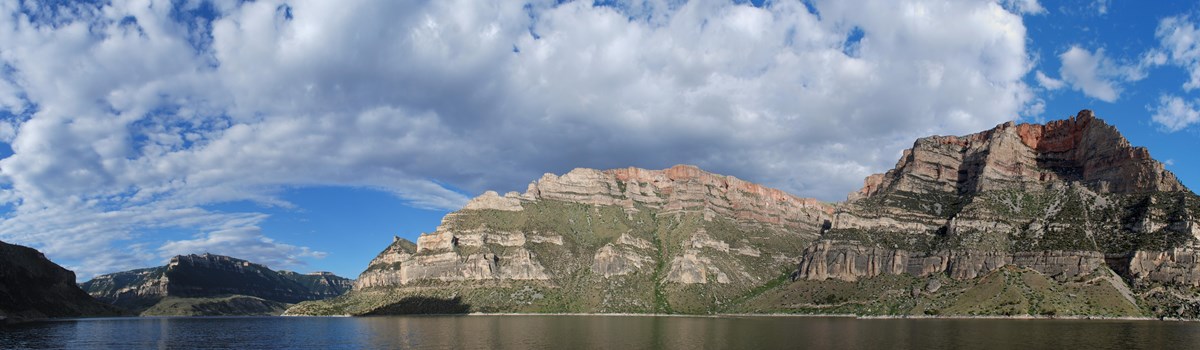
At first glance, time seems to have stopped at Bighorn Canyon. The lake and the steep-sided canyons provide a peaceful setting for those seeking a break from the daily routine. The focus of the area is 71-mile-long Bighorn Lake, created by Yellowtail Dam near Fort Smith, Mont. Dedicated in 1968, the dam provides electric power, water for irrigation, flood control, and recreation. Boating, waterskiing, fishing, swimming, and sightseeing are main attractions.
While you enjoy the play of light and shadow on rock and water, take time to contemplate the changes that the land and the life upon it have undergone. Time and water are keys to the canyon, where the land has been shaped by moving water since upheavals of the Earth's crust built the Pryor and Bighorn mountains millions of years ago. For 15 miles upstream from the dam, the lake bisects a massive, arching anticline, exposing fossils that tell of successive times when this land was submerged under a shallow sea, when it was a tropical marsh, and when its conifer forests were inhabited by dinosaurs. Humans arrived here more than 10,000 years ago, living as hunters and gatherers. In modern times people have further altered the land.
Most of Bighorn's visitors come to enjoy the recreational opportunities the lake offers. Boaters, waterskiers, anglers, and scuba divers find attractions here. But the park offers more than just the lake—from the wildflowers in spring and summer to more than 200 species of birds—and from the stories of life forms adapting to a harsh environment to the modern search for energy. You can get more information on what the park offers at visitor centers near Lovell, Wyo., and Fort Smith, Mont. We hope you will find your own place of solitude to relax and to enjoy the diversity and timelessness of this uncommon canyon waterland.
A Challenging Land
In North America people have traveled and made their living along rivers and streams for more than 40,000 years. But the Bighorn River was too treacherous and too steep-walled. People here lived near the Bighorn but avoided navigating it—until the dam tamed the river.
The broken land here also challenged the ingenuity of early residents, forcing them to devise unusual strategies of survival. More than 10,000 years ago, Indian hunters drove herds of game into land traps. These Indians lived simply, gathering wild roots and seeds to balance and supplement their meat diet. They made clothes of skins, baskets and sandals of plant fibers, and tools of stone, bone, and wood. The many caves of the Bighorn area provided seasonal shelters and storage areas for the Indians, as well as for early traders and trappers.
Absaroke means "People of the large-beaked bird," in the Siouan language of the Crow. Their reservation surrounds most of Bighorn Canyon. Originally a farming people, the Crow split off from the Hidatsa tribe more than 200 years ago. They became a renowned hunting people, described by one of the Lewis and Clark Expedition as "the finest horsemen in the world."
After 1800 explorers, traders, and trappers found their way up the Bighorn River. Charles Larocque met the Crow at the mouth of the Bighorn in 1805; Captain William Clark traveled through a year later. Jim Bridger claimed he had floated through the canyon on a raft. Later fur traders packed their goods overland on the Bad Pass Trail, avoiding the river's dangers.
During the Civil War the Bozeman Trail led to mines in western Montana by crossing the Bighorn River. Open from 1864 to 1868, the trail was bitterly opposed by Sioux and Cheyenne; the Crow were neutral. The Federal Government closed the trail in 1868 after the Fort Laramie Treaty. Fort C.F. Smith, now on private land, guarded the trail as an outpost. A stone monument commemorates the Hayfield Fight, a desperate but successful defense against Sioux and Cheyenne warriors. In this skirmish a party of soldiers and civilian haycutters, working three miles north of Fort C.F. Smith, fought for eight hours until rescued by the fort's troops on August 1, 1867.
After the Civil War cattle ranching became a way of life. Among the huge open-range cattle ranches was the Mason-Lovell (the ML); some of those buildings remain. Dude ranching, reflected in the remains of Hillsboro, was popular in the early 1900s.
The Crow made the transition from hunter-gatherers to ranchers in one generation. In 1904, after 12 years of labor, they completed an irrigation system and opened 35,000 acres of land to irrigated farming. Water was diverted into the Bighorn Canal by a 416-foot diversion dam, moving 720 cubic feet of water per second. Near Afterbay Campground is Bighorn Canal Headgate, remains of this human response to the challenge of the land.
Congress established Bighorn Canyon National Recreation Area in 1966 as part of the National Park System to provide enjoyment for visitors today and to protect the park for future generations.
Land and Life at Bighorn
Bighorn Canyon Visitor Center
The solar-heated visitor center near Lovell, Wyo., symbolizes the
energy-conscious concerns of the National Park Service and of modern
Americans. The heating is accomplished by storing heat from the sun in a
rock bin, then blowing hot air through the building. The Yellowtail Dam
Visitor Center, in the park, is two miles past the community of Fort
Smith. It is approachable from the north by car.
Pryor Mountain Wild Horse Range
In 1968 this area was established to provide a well-maintained sanctuary
for wild horses. The herd size of about 120-140 is managed by the Bureau
of Land Management.
Bighorn Wildlife
The wildlife of the Bighorn Canyon country is as varied as the land,
which can be divided into four climate or vegetative zones. In the south
is desert shrubland inhabited by wild horses, snakes, and small rodents.
Midway is juniper woodland with coyotes, deer, bighorn sheep, beaver,
woodrats, and porcupine. Along the flanks of the canyon is pine-and-fir
woodland with mountain lions, bear, elk, and mule deer. In the north is
shortgrass prairie, once home to herds of buffalo. Many of the smaller
animals, such as cottontails, skunks, coyotes, and rattlesnakes, are
seen frequently throughout the park. More than 200 species of birds,
including many kinds of waterfowl, have been seen here. Each plant and
animal species is adapted to the particular conditions of temperature,
moisture, and landform within one or more of the park's four primary
zones.
Yellowtail Dam
The dam is named in honor of Robert Yellowtail, former Crow tribal
chairman and reservation superintendent. The dam creates one of the
largest reservoirs on the Missouri River tributary system. This arch
type dam is 525 feet high.
Yellowtail Wildlife Habitat Management Area
Riparian, cottonwood forest, shrubland, and wetlands provide habitat for
white-tailed deer, bald eagles, pelicans, heron, waterfowl, wild
turkeys, and other species. The area is managed by the Wyoming Game and
Fish Department through agreements with the National Park Service,
Bureau of Land Management, and Bureau of Reclamation.
Ranch Sites
• Mason-Lovell Ranch: A.L. Mason and H.C Lovell built cattle ranch
headquarters here in 1883. Cattle roamed the Bighorn Basin in a classic
open-range operation. • Hillsboro: A one-mile roundtrip trail takes
you to the site of Grosvenor William Barry's Cedarvale Guest Ranch and
the 1915 to 1945 Hillsboro post office. • Lockhart: Caroline
Lockhart, a reporter, editor, and author, began ranching at age 56. The
well-preserved buildings give a feel for ranch life; one-mile roundtrip.
• Ewing-Snell: This site was in use for nearly 100 years.
Bad Pass Trail
American Indians camped along this trail 10,000 years ago, and in
prehistoric and historic time Shoshone used it to get to the buffalo
plains. Early trappers and traders used it to avoid the dangers of the
Bighorn River. You can see rock cairns left along the route between
Devil Canyon Overlook and Barry's Landing. Before the arrival of the
horse, life changed little here for thousands of years. Small family
groups wintered in caves near the canyon bottoms. In early spring they
moved out of the canyon bottoms in search of plants and small animals,
and in summer they moved to the highlands in search of game and
summer-maturing plants. Large groups gathered in fall for a communal
bison hunt.
Devil Canyon Overlook
Here the canyon crosscuts the gray limestone of the Devil Canyon
Anticline, a 1,000-foot high segment of the fault blocks that make up
the Pryor Mountains.
About Your Visit
 (click for larger map) |
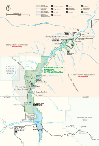
No road connects the park's north and south ends directly. To visit both, use the map to choose a route. Be sure to stop at the Bighorn Canyon Visitor Center at Lovell, Wyo., or the Yellowtail Dam Visitor Center near Fort Smith, Mont.
Getting Here To get to the park's south end, take U.S. 310 from Billings, Mont., or U.S. 14A from Sheridan, Wyo. To reach the north end, take Mont. 313 from Hardin, Mont. You can rent cars in nearby communities, but no public transportation serves the park. Scheduled airlines do serve Cody, Wyo., and Billings. Transcontinental buses serve Greybull, Cody, Lovell, and Powell, Wyo., and Billings and Hardin, Mont. Unattended aircraft landing strips are at Fort Smith and Cowley, Wyo.
Accommodations Hotels, motels, restaurants, service stations, and grocery and sporting goods stores are in Lovell and Hardin. At the park's north end, Fort Smith has motels and a restaurant, service station, and grocery store.
Private Property The Crow Indians own property within the boundaries of the national recreation area. Tribal lands are closed to the public. Check with a park ranger for more information.
More Information Contact the park to plan your visit in advance—especially if you will be bringing a group.
Boating Tips Get a copy of the park's boating brochure and map before you head for the water. It shows the boating facilities, boat ramps, navigational markers, and campgrounds for Bighorn Lake. More information includes the regulations for boating safety while you are on the lake. Please read the boating brochure carefully and observe all rules and warnings. For your safety, sign the registration sheet at the boat ramps.
What to See and Do
A film at Bighorn Canyon Visitor Center highlights park activities. Exhibits explain the canyon's history and natural features.
Boating enthusiasts will find a marina, snack bar, campstore (gas and oil), and boat ramp at Horseshoe Bend and Ok-A-Beh. Ramps are also at Afterbay Dam and Barry's Landing. All boaters should sign registration sheets at the ramps when entering and leaving the lake. If mechanical problems develop while you are on the lake, stay with your boat; hail other boaters and ask them to notify a ranger. Carry both day and night signaling devices. Do not try to climb the lake's steep canyon walls.
Swimmers are encouraged to use the lifeguarded areas at Horseshoe Bend and Ok-A-Beh.
Camping is restricted to designated sites in developed areas. It is also allowed in the backcountry and below the highwater mark along Bighorn Lake. Fire restrictions during periods of high fire danger may close certain areas to camping. Check with a ranger for the restrictions on fires or backcountry camping.
Hiking is available in the national recreation area and in nearby forests. Ask at the visitor centers for more information.
Hunting is allowed in designated areas in accordance with state laws. Trapping is prohibited.
Fishing in Montana or Wyoming requires the appropriate state fishing license. Fine game fish, such as brown and rainbow trout, sauger, ling, and perch, abound. The most popular game fish, a gourmet's delight, is the walleye. Winter ice fishing around Horseshoe Bend is good. The Bighorn River provides excellent brown and rainbow trout fishing.
Regulations and Safety: Firearms are prohibited in developed areas and areas of concentrated public use, unless they are unloaded and cased. Pets must be on a leash in developed areas and in areas of concentrated public use. Trash and waste disposals into area waters are prohibited; all vessels must have a waste receptacle on board. Carry a first-aid kit as a precaution against poisonous snakebites.
All plants, animals, natural and cultural features, and archeological sites are protected by federal law. Collecting is prohibited.
Source: NPS Brochure (2004)
|
Establishment Bighorn Canyon National Recreation Area — October 15, 1966 |
For More Information Please Visit The  OFFICIAL NPS WEBSITE |
Documents
A Preliminary Assessment of Paleontological Resources at Bighorn Canyon National Recreation Area, Montana and Wyoming (Vincent L. Santucci, David Hays, James Staebler and Michael Milstein, 1999)
A Symbol of Progress?: Memories of Bighorn Canyon and Yellowtail Dam (Shawn Bailey and Jonathan Hall, October 15, 2011)
Assembling History: The River Before the Dam Collection, Bighorn Canyon National Recreation Area Draft (2012-2013)
Bad Pass Archaeology (Laura L. Scheiber, Judson Byrd Finley and Maureen P. Boyle, extract from The American Surveyor, April/May 2008, ©Cheves Media)
Caroline Lockhard Ranch, Bighorn Canyon National Recreation Area Draft (Mary Shivers Culpin, October 1981)
Every Morning of the World: Ethnographic Resources Study, Bighorn Canyon National Recreation Area (Peter Nabokov and Lawrence Loendorf, 1994)
Foundation Document, Bighorn Canyon National Recreation Area, Montana-Wyoming (March 2016)
Foundation Document Overview, Bighorn Canyon National Recreation Area, Montana-Wyoming (February 2017)
Geologic Resources Inventory Report, Bighorn Canyon National Recreation Area NPS Natural Resource Report NPS/NRPC/GRD/NRR-2011/447 (K. KellerLynn, September 2011)
Geology of the Bighorn Canyon-Hardin area, Montana and Wyoming USGS Bulletin: 1026 (1955)
Historic Basic Data, Bighorn Canyon National Recreation Area, Montana-Wyoming: Volume 1 (Edwin C. Bearss, February 1970)
Historic Basic Data, Bighorn Canyon National Recreation Area, Montana-Wyoming: Volume 2 (Edwin C. Bearss, February 1970)
Historic Structure Report and Historic Resource Study, Historical Data Section-Ewing (Snell) and ML Ranches, and Hillsboro (Edwin C. Bearss, March 1974)
Historic Structures Report: Hillsboro (Cedarvale), Bighorn Canyon National Recreation Area, Part III: Architectural Data (Peter Snell, 1975)
Integrated Weed Management Program Environmental Assessment, Bighorn Canyon National Recreation (January 2004)
Junior Ranger Booklet, Bighorn Canyon National Recreation (Date Unknown; for reference purposes only)
Long-Range Interpretive Plan, Bighorn Canyon National Recreation (May 2012)
National Register of Historic Places Nomination Forms
Bad Pass Trail (Sioux Trail) (George C. Mackenzie, August 1, 1974)
Bighorn Ditch Headgate (Rodd L. Wheaton, January 12, 1976)
Caroline Lockart Ranch (Paul Gordon, April 12, 1988)
Hillsboro (Cedarvale) (Virgil J. Olson, September 20, 1974)
Ewing-Snell Ranch (Sorenson Ranch) (Rodd L. Wheaton, January 12, 1976)
M L Ranch (Mason-Lovell Ranch) (Paul Gordon and Kathy McCraney, March 5, 1992)
Old Ft. C.F. Smith (Virgil J. Olson, January 24, 1975)
Pretty Creek Archeological Site (Wilfred D. Logan and G.C. Mackenzie, August 1, 1974)
Natural Resource Condition Assessment, Bighorn Canyon National Recreation Area NPS Natural Resource Report NPS/BICA/NRR-2012/554 (M. R. Komp, A. J. Nadeau, E. Iverson, L. Danzinger, S. Amberg, K. Kilkus, J. Sopcak, C. Jean, M. Myers and B. Drazkowski, July 2012)
Park Newspaper (Canyon Echoes): June 1991 - May 1992 • 2010 • 2011 • 2013
Personal Watercraft Use Environmental Assessment, Bighorn Canyon National Recreation (April 2003)
Relict Aspen Stand at Bighorn Canyon National Recreation Area, Montana NPS Natural Resource Report NPS/BICA/NRR-2017/1540 (Joseph E. Steven, Karin L. Decker and Beth M.L. Morrison, October 2017)
Statement for Management — Bighorn Canyon National Recreation Area (November 1992)
Strategic Plan: 2001-2005, Bighorn Canyon National Recreation Area (2000)
Subaqueous tetrapod swim tracks from the Middle Jurassic: Bighorn Canyon National Recreation Area (BCNRA), Wyoming, U.S.A. (Debra L. Mickelson, Michael Ryan King, Patrick Getty and Katherine A. Mickelson, New Mexico Museum of Natural History & Science Bulletin 34, 2006, ©New Mexico Museum of Natural History and Science, all rights reserved)
bica/index.htm
Last Updated: 01-Jan-2025