OPPORTUNITY AND CHALLENGE
The Story of BLM
|
|
|
PROLOGUE:
The Public Domain From 1776-1946
There was nothing but land; not a country at all,
but the material out of which countries are made.
—Willa Cather
My Antonia, 1918
|
PROLOGUE
The Public Domain from 1776-1946
|
|
|
The Bureau of Land Management (BLM) today administers
what remains of the nation's once vast land holdings—the public
domain. The public domain once stretched from the Appalachian Mountains
to the Pacific and "constituted," in historian Frederick Jackson Turner's
mind, "the richest free gift that was ever spread out before civilized
man." Of the 1.8 billion acres of public land
acquired by the United States, two-thirds went to individuals,
corporations, and the states. Of that remaining, much was set aside for
national forests, wildlife refuges, national parks and monuments, and
other public purposes, leaving BLM to manage some 270 million acres, as
well as 570 million acres of mineral estate.
|
|
Overview |
|
Lands managed by BLM are often scattered and take on
checkerboard, jigsaw, and patchwork patterns, but in much of the Great
Basin, desert Southwest, and Alaska, solid blocks of public land
predominate. These land patterns are inherited: the result of the public
land policies pursued by the country prior to the agency's founding in
1946.
To the young American nation the public domain
represented challenge and opportunity—a wilderness waiting to be
transformed into an agricultural Eden. The nation also needed revenue. A
policy of disposing of public lands through auction seemed to meet both
these needs. As the need for revenue lessened, policy shifted to one of
development and lands were generously provided to settlers,
corporations, and the states. But as the public domain diminished, the
government chose to set aside timber, mineral, and grazing lands and
regulate their development as a means of preserving the opportunity of
the public domain.
|
|
|
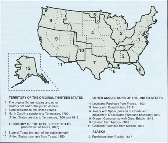
ACQUISITION OF THE PUBLIC DOMAIN
|
|
|
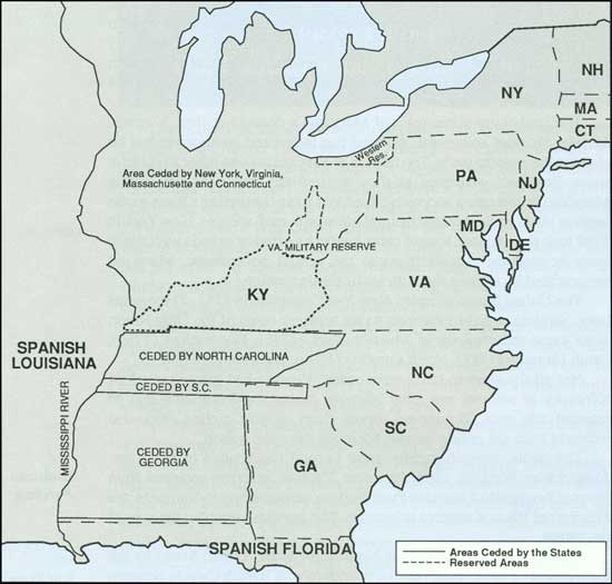
"The back Lands [sic] claimed by the British
Crown," contended Maryland legislators in November 1776, "if secured
by the blood and treasure of all, ought in reason, justice, and policy...be
considered as a common stock." With that declaration, Maryland
raised the issue of what should become of the territory between the
Appalachian Mountains and the Mississippi River. The issue proved
contentious and threatened the bonds that held the new union of states
together.
|
|
Original
Public
Domain |
|
Seven states had claims to the region. Virginia,
Massachusetts, Connecticut, North Carolina, South Carolina, and
Georgia had early colonial charters from England granting them title to
the lands beyond the Appalachians. New York's claim resulted from
concessions by the Iroquois Indians. The remaining states had no claims to the
area.
For states without land claims, like Maryland, the
disposition of western lands was of major importance. They needed
land to reward the soldiers who served in their regiments against the
British. Maryland also feared that if Virginia and the other land-claim
states took title to lands in the trans-Appalachian West, they would
dominate the nation economically and politically. Maryland demanded that
the land-claim states relinquish their title to the central government
and vowed not to sign the Articles of Confederation until that was
done.
The land-claim states resisted Maryland's demand at
first. Virginia, Maryland's chief antagonist, declared that the central
government had no claim to the western lands. The resolve of Virginia
and the other land-claim states, however, weakened as they realized the
importance of having Maryland in the union and recognized that their
conflicting claims to the western lands could threaten their relations
with each another. New York in 1780 took the first step toward
compromise by offering to cede its claim to lands beyond the
Appalachians to the central government. Maryland reciprocated by signing
the Articles of Confederation.
The United States accepted New York's cession in 1781.
Three years later, Virginia ceded its interests to the territory
north of the Ohio River. Then came the cessions of Massachusetts (1785),
Connecticut (1786), South Carolina (1787), North Carolina (1790), and
Georgia (1802).
Not all the western lands were ceded. Virginia had
granted much of Kentucky to soldiers and other interests during the
Revolution and so retained this area. Tennessee, carved from North
Carolina, was also withheld from the public domain for much the same
reason.
|
|
|
The public domain rapidly grew beyond the bounds of
the trans-Appalachian West. In 1803, President Thomas Jefferson acquired
from France (through the Louisiana Purchase) the immense
region drained by the Mississippi River's western tributaries. The purchase
doubled the size of the nation.
|
|
Louisiana
Purchase |
|
The Red River Valley of the North came to the United
States by the Convention of 1818, which set the boundary with
British Canada between Lake Superior and the Rocky Mountains at the 49th
Parallel. By treaty with Spain the following year, Florida was acquired and
the western border of the Louisiana Purchase redrawn.
|
|
Red
River
Country |
|
America's "Manifest Destiny" to span the continent
was fulfilled in the 1840s. The United States and Britain in 1846 ended
their joint occupation of the Oregon Country by dividing the region
along the 49th Parallel. That same year also saw the beginning of war
with Mexico. American troops seized control of New Mexico and
long-coveted California, and by the Treaty of Guadalupe Hidalgo in 1848,
the United States took title to the Southwest from Mexico for $15
million.
|
|
Oregon
Country
and the
Southwest |
|
When Texas joined the Union in 1845, it retained
title to its vacant and unappropriated lands. The federal government,
however, purchased the northwest portion of Texas in 1850 and added it
to the public domain. Three years later, James Gadsden negotiated the
purchase of 19 million acres along the Mexican border needed for a
southern transcontinental railroad route. The region was described at
the time by Missouri Senator Thomas Hart Benton as "utterly desolate,
desert, and God-forsaken."
|
|
Texas and the
Gadsden
Purchase |
|
|
Western land cessions by the original states
|
|
|
"Most astonishing of all the United States' acquisitions of territory,"
in public land historian Paul Wallace Gates' mind, "was the purchase of
Alaska." Americans had expressed no interest in the northern
icebox. The Russian Tsar, however, wanted to sell, and in 1867
Secretary of State William H. Seward obliged. For $7.2 million, the United States
acquired more than 365 million acres and made its last addition to the public
domain.
|
|
Alaska |
|
THE LAND ORDINANCE OF 1785
|
|
|
When New York offered to relinquish its claim to the
western lands in 1780, the Congress of the Confederation responded with
a pledge that "the unappropriated lands that may be ceded or
relinquished to the United States, by any particular state...shall be
disposed of for the common benefit of the United States." This raised
the issue of how public lands should be disposed of.
|
|
|
|
Aquisition of the public domain
|
|
|
Most in Congress agreed that the public lands should
be used as a source of revenue for the nation's cash-starved treasury
and provide land, as promised, to soldiers who had enlisted in the
Continental Army. There was sharp difference, however, as to how
disposal should be carried out.
|
|
Land System
Debate |
|
Most southern delegates favored a system of
indiscriminate location and subsequent survey, as had been the practice
in their states. Others advocated more orderly settlement, voicing
arguments set forth by Thomas Jefferson, that indiscriminate location
with subsequent survey led only to costly and protracted lawsuits as
owners sought to establish boundaries. What they wanted was a system,
like in New England, where survey preceded settlement.
|
|
|
The Confederation in the Land Ordinance of May 20,
1785, opted for the policy of orderly settlement. After Indian title
issues had been quieted by treaty, the public lands were to be surveyed
and numbered by the Geographer of the United States into townships, 6
miles square, and seven ranges. (In this, a rectangular survey system,
townships are numbered in a north-south direction; ranges, in an
east-west direction.) One-seventh of the townships, selected at random,
were to be used to satisfy military land warrants. The remaining
townships were to be auctioned at not less than $1
an acre. Half the townships were to be offered whole
and the other half in "lots," later called sections, 1-mile square. The
United States reserved Lot 16 in each of the townships to provide
revenue for public schools as well as four other lots for later sale.
The government also reserved rights to one third interest in any gold,
silver, lead, or copper that might be found.
|
|
Land
Ordinance
Provisions |
|
Operation of the Land Ordinance disappointed
Confederation officials. Surveys were slow. The Geographer of the United
States Thomas Hutchins began work in the fall of 1785,
but dense forests, swamps, and the threat of Indian attack resulted in
the survey of only four ranges after 2 years of work.
|
|
Surveys Begin |
|
Impatient to sell public lands and bring revenue into
the treasury, Congress ordered the completed townships auctioned in
the fall of 1787. Not one whole township sold and
only 108,431 acres were bid for. Indian troubles, the distance of the lands from agricultural
markets, and the availability of cheaper lands in the original 13
states were all factors contributing to the lack of interest.
|
|
First Land
Sale |
|
Desperate for revenue, the Confederation abandoned
the Land Ordinance of 1785 and contracted to sell public
lands, without competition, to two speculative land companies: 1.5 million acres to
the Ohio Company and 1 million to a company headed
by John Cleve Symmes. Both offered Congress mere pennies per acre but, in the end, were
able to purchase only a portion of the lands contracted.
|
|
Sales to
Speculators |
|
EARLY PUBLIC LAND POLICY
|
|
|
The United States ratified the Constitution in 1788,
rendering the Land Ordinance of 1785 inoperable. A new public land policy
had to be enacted. By Article IV, Section 3, Clause 2, of the
Constitution, the task fell to Congress, for it had the "Power to dispose of and
make all needful Rules and Regulations respecting the Territory and other
Property belonging to the United States."
|
|
Constitution
and the Public
Domain |
|
Congress debated the public lands questions for
several years but no general policy was enacted until 1796.
Interestingly, the debates did not center on whether the public lands
should continue as a source of revenue, since the national debt
continued to be troublesome, but rather to whom the lands should be
sold. Secretary of the Treasury Alexander Hamilton wanted the lands sold
to capitalists and land companies who could pay top price for public
lands. Pennsylvania Congressman Albert Gallatin, an adherent of Thomas
Jefferson thinking on public land matters, did not oppose Hamilton's
thinking, but did urge that cash poor farmers be accommodated.
|
|
Land System
Debate
Renewed |
|
The Land Law of 1796 sought a compromise between the
positions. The law provided for the disposal of the public lands north
of the Ohio River by the Department of the Treasury. Lands could be
purchased in unlimited quantities at the minimum price of $2 per acre,
with the full balance not due for a year. Half the townships sold in
quarter townships, the other half was offered in 640-acre sections.
Congressman Gallatin and his supporters hoped that settlers would pool
their resources to buy the 640-acre tracts, but when bidding for prime
agricultural land, monied interests had the advantage.
|
|
Land Law of
1796 |
|
JEFFERSON AND HAMILTON AND THE PUBLIC
LANDS
by Jerry A. O'Callaghan
Volunteer Historian
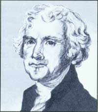
Thomas Jefferson (Jennifer Reese)
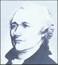
Alexander Hamilton (Jennifer Reese)
|
Thomas Jefferson, the nation's first Secretary of
State, and Alexander Hamilton, its first Secretary of the Treasury, had
strong opposing views on which social/economic groups could best
guarantee the future of the new nation.
Jefferson, a Virginia landowner, wanted
self-sufficient family farmers as the base from which to build
the new nation. He assumed they would produce enough to feed and clothe
themselves, and sell the surplus to buy other necessities. Because they
were landowners, Jefferson also assumed they would take an interest in
public affairs. Their rural lives would allow them to study public
issues and officials, unswayed by the commercial, industrial, or
financial preoccupations of cities.
Jefferson wanted the government to sell public lands
to small farmers in tracts that would provide the self-sufficiency he
envisioned. In short, Jefferson's public lands strategy was to retail
small tracts at cut rate.
Hamilton, a New York lawyer, cast his lot with, in his
words, "the rich, the able, and the well-born," who could organize and
finance commercial and industrial enterprises. Hamilton's plan was more
complicated. He saw public lands as a way to back the government bonds
sold to merchants, bankers, and others. He favored auctioning public
lands in large blocks to promote maximum revenue with low overhead. By
investing in land, "the rich, the able, and the well-born" helped
guarantee revenue that would return their capital with annual
interest.
Hamilton's strategy, then, was to sell public lands
at wholesale and bind the merchants and bankers to the new nation.
Hamilton's view prevailed in the Public Land Act of 1796. Hamilton's
plan required small farmers to buy their farms from those who had the
money to respond to his strategy. Small farmers did not stand still for
such treatment. Their aggravation brought on the Land Act of 1800, which
authorized local land offices, reduced the minimum size for purchase and
extended credit. In 1820 credit was abolished, but the minimum price was
lowered. The ultimate in the retail policy was the Homestead Act of
1862. Under it, at no cash costs other than fees, settlers could buy
160-acre, self-sufficient farms with their time and labor.
Jefferson's views quickly supplanted Hamilton's.
Nevertheless Hamilton has prevailed over all with national and
international markets placing a premium on one-crop farming—the
antithesis of self-sufficient farming. Such commercial agriculture gives
great economic rewards. It also takes them away. Jefferson's influence
is present in federal agricultural policy to mitigate wide market swings
and natural disasters such as drought.
|
|
|
Another notable feature of the Land Law of 1796 was
the retention of the rectangular survey system established by the Land
Ordinance of 1785. As before, public lands were to be surveyed before
sale. Surveys were to be contracted to independent surveyors who would
follow the direction of a surveyor general. In executing township
surveys, they were to note "all mines, salt licks, salt springs, and
mill-seats...all water-courses...and also the quality of the lands" in
their notebooks, so that purchasers could be informed about the
character of the lands being offered.
|
|
Rectangular
Survey System |

|
|
Township configuration under the Land Law of 1796
|

|
|
Township configuration under the Land Ordinance of 1785
|
|
|
The sale of public lands came 2 years later. The
results, as with the earlier Land Ordinance, were disappointing. At
auctions held in Philadelphia and Pittsburgh, less than 50,000 acres
sold. Congress reacted to the poor showing by amending the Land Law of
1796.
|
|
|
The Land Law of 1800 embodied many provisions
advocated by frontier interests. Tracts offered for sale were reduced to
half sections (320 acres) and purchasers were given 4 years to pay the
amount bid, with an 8 percent discount if the entire amount was paid at
the time of auction. Another important feature of the act was the
establishment of land offices in Cincinnati, Chillicothe, Marietta, and
Steubenville. The offices were near the lands being sold and gave
westerners an opportunity to bid on the offered lands.
|
|
Land Law of
1800 |
|
The local land office became an important center of
activity on the frontier. Here, people made entry for the public lands.
Administering the offices were a register and receiver, appointed and
removed at the discretion of the President. The register entered the
land applications in the record books and on the survey plats of the
office. The receiver handled all payments and receipts. These actions
were supervised by the Secretary of the Treasury in Washington. Land
offices were moved or closed as the public lands within their
jurisdictions dwindled or as new public lands were being surveyed and
opened to entry. More than 360 district land offices were ultimately
established.
|
|
Local Land
Office System |
|
The Land Law of 1800 stimulated a sharp increase in land sales. By the
close of 1802, more than 750,000 acres had been sold. Further
stimulation came with the Land Law of 1804, which extended credit
payments and reduced the size of tracts offered for auction from 320 to
160 acres.
|
|
Land Law of
1804 |
|
Congress also opened the public lands south of Tennessee to sale. The
Land Law of 1803 ordered the region surveyed under the rectangular
system and sold in the manner set forth by the Land Law of 1800.
Hundreds of thousands of acres in the South were soon put on the market
and sold.
|
|
Public Lands
in the South |
|
THE GENERAL LAND OFFICE
|
|
|
To handle the rapidly growing public land business,
Congress created the General Land Office (GLO) in 1812. Headed by a
commissioner, the GLO was given the responsibility to "superintend,
execute, and perform all such acts and things touching or respecting the
public lands of the United States." Previously, public land sales had
been handled directly by the Secretary of the Treasury, while the
Department of War had administered military land warrants and the State
Department, land patents. The General Land Office was placed within the
Treasury Department until 1849, when it was transferred to the new
Department of the Interior.
|
|
Duties and
Function |
|
|
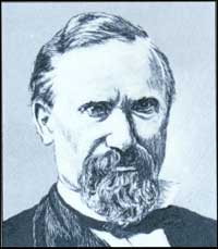
Edward Tiffin (BLM)
|
|
|
|
Responsibility for organizing the GLO went to Edward
Tiffin, its first commissioner. Tiffin, a physician,
former U.S. Senator, and farmer,
set about the task without delay. With a chief clerk and staff of eight,
Tiffin consolidated the land records spread throughout Washington and
began the daily business of processing land entries.
|
|
First GLO
Commissioner |
|
THE BOOM AND BUST CYCLES OF PUBLIC LAND SALES
|
|
|
Public land sales declined with the outbreak of war
with Great Britain in 1812. After the war, however, there was an
unprecedented rush for public lands. Land cessions by the Indians
defeated during the War of 1812 opened the trans-Appalachian region to
farmers and speculators, but the main catalyst for the coming boom was
the rise in agricultural prices. The GLO auctioned off 1.5 million acres
of public land in 1815; within 4 years, 5.5 million acres had been sold.
Competition for land was intense. In some parts
of the South, prime cotton land sold for as much as
$78 an acre.
|
|
Land Rush |
|
COMMISSIONERS OF THE GENERAL LAND
OFFICE
by Jerry A. O'Callaghan
Volunteer Historian
Editor's Note: Jerry O'Callaghan, a 21-year veteran
of BLM, has been a volunteer historian for the Bureau since retiring in 1982 as Assistant
Director of Lands and Minerals.
The Commissionership of the General Land Office has
been one of the nation's most prestigious and sought-after posts. When
Abraham Lincoln's strong bid in 1849 failed, he was so disappointed that
he took a long leave from politics.
Thirty-four Commissioners of the General Land Office
presided over the distribution of one billion plus acres of public
lands—roughly half of the United States' total land area. The
distribution is possibly the largest and most beneficent real estate
deal in history, giving the language an idiom, "doing a land office
business," for a high volume of retail trade.
The General Land Office was created in 1812 to
relieve the Secretary of the Treasury from having to oversee directly
the local land offices. It was a quasi-judicial, ministerial office
centralized in Washington, and became part of the newly formed
Department of the Interior in 1849.
Edward Tiffin, the first commissioner, combined a
long public career with the practice of medicine. When the British
burned Washington's federal buildings in 1814, Tiffin arranged for the
removal of the land records to safety across the Potomac River.
So he could return to Ohio, Tiffin arranged a trade
with Josiah Meigs, the Surveyor-General, with Tiffin himself becoming
Surveyor-General stationed in Cincinnati. Incidentally, Tiffin has been
considered a superb Surveyor-General, a position closely related and
equally important to that of the Commissioner of the General Land Office
to which it later became subordinate.
No commissioner became President, but John McLean
became an Associate Justice of the United States and was often talked
about as a presidential candidate. Thomas A. Hendricks, after his
commissionership, served in the U.S. House of Representatives and U.S.
Senate. He was able to serve only nine months of his term as Vice
President before his death.
Although he served as commissioner a short time,
James Shields must have been very persuasive. He went on to become a senator from
Minnesota, California, and Missouri.
William Sparks was an aggressively forthright
commissioner. His efforts to redress what the public saw as preferential
treatment of the land grant railroads, syndicates and speculators, to
the disadvantage of actual settlers, aroused congressional and press
ire. Three of his annual reports in the mid-1880s were cogent arguments
for public land reform. Both L.C.Q. Lamar, Secretary of the Interior,
and President Cleveland backed him, but Sparks resigned before his term
was over in a difference with Lamar on a railroad case.
Many commissioners had been state governors. The
last, Fred Johnson, was also, briefly, the
Bureau of Land Management's first director.
|
|
|
Then came panic.
America's economy collapsed in 1819. Cotton and other
agricultural prices plummeted and banks failed. The economic depression
threatened the financial stability of the United States. During the land
rush, speculators had taken advantage of the federal government's
liberal payment terms; at the time of the collapse, nearly $23 million
was still owed to the Treasury.
|
|
|
Congress quickly abandoned the credit system. The
Land Law of 1820 discontinued the sale of lands on credit. Full payment
for land had to be made at the time of purchase. However, buyers could
now purchase land for as little as $1.25 an acre and the size of tracts
could be as small as 80 acres. The buyers could still purchase public
lands in unlimited quantities and lands not sold at auction were subject
to private entry at the minimum price.
|
|
Land Law of
1820 |
|
Land speculation did not end with the Land Law of
1820. Although sales declined with the panic of 1819, they increased
steadily during the 1820s. A big jump in land sales came in 1835 when
the acreage sold climbed to 12.5 million acres from the previous year's
4.6 million acres. In 1836, more than 20 million acres were sold. This
surge in sales resulted from an improved economy, an expanded road and
canal system in the West, available money, and the opening of new lands
west of the Mississippi River created by the federal government's
removal of trans-Appalachian Indian tribes.
|
|
Land Sales in
1830s |
|
The federal government was "doing a land-office
business" and the increased sales enabled it to pay off the national
debt. The rampant speculation, however, was being financed by state
bank-issued currency of uncertain value. This fact forced President
Andrew Jackson to issue the Specie Circular of 1836 requiring all
payments for public land to be made in gold and silver coin. This action
brought an end to the land sale boom and sales once again declined.
|
|
|
MILITARY VETERAN LANDS AND PRIVATE LAND CLAIMS
|
|
|
The General Land Office was concerned with more than
land sales during these years. There were also military land warrants
and private land claims.
|
|
|
At the outbreak of the Revolution, the Continental
Congress and states offered land bounties to recruits who joined the
army and navy. The federal government offered the same incentives used
to raise an army for the War of 1812. Giving land for military service
was a time-honored practice. Historian Paul Gates points out that the
practice recognized "that land was not always easy to obtain, was much
in demand, and that a land bounty might prove more attractive than
anything else the government could promise."
|
|
Military Land
Bounties |
|
The amount of land offered to soldiers varied
according to rank. Privates in the Continental Army during the
Revolution received 100 acres, whereas major generals got 1,100
acres.
The call for Virginia and the other land-states to
relinquish their claims to the region west of the Appalachian Mountains
was partly spurred by the need to provide land to soldiers and sailors.
The Land Ordinance of 1785 provided that one-seventh of the townships
surveyed in the first seven ranges be set aside for the location of
military land warrants. Congress later established a military district
in Ohio for the location of these warrants. Other military bounty land
reserves were established in Illinois, Missouri, and Arkansas after the
War of 1812. In 1842, Congress began permitting veterans to select
public lands outside the military districts.
The policy of giving land bounties for military
service continued until the Civil War. War veterans were then given the
privilege of deducting all or part of their military service from the
period of residence and cultivation required under the Homestead
Act.
|
|
|
Private land claims were another concern for the
General Land Office. With each addition to the public domain, the United
States recognized land titles granted by previous sovereigns. This
required verifying claims and issuing patents to confirm titles.
|
|
Private Land
Claims |
|
Adjudication of private land claims was difficult.
Claims often conflicted and rights of ownership complicated by missing
documents. Fraudulent title papers were another problem. Sorting out the
titles required lengthy hearings to determine the legitimacy of the
claims.
The first claims came with the acquisition of the
trans-Appalachian frontier. With the purchase of Louisiana from France
the GLO was swamped with private claims given by both the French and the
Spanish. Thousands of claims were presented, most for lands in Missouri
and Louisiana. To expedite adjudication, Congress established land
commission boards, but the poor documentation for most title claims
slowed their confirmation. Several thousand claims remained outstanding
for more than 50 years.
|
|
|
THE POLICY OF PREEMPTION
|
|
|
The federal government's policy of auctioning public lands had
always placed frontier settlers at a disadvantage compared with monied
capitalists and speculators. Frontier farmers found money hard to
come by, forcing many to build a home, clear land, and eke out what income
they could on unsurveyed public lands.
|
|
Pioneer
Dilemma |
|
The policy of orderly settlement, however, sought to dissuade such
squatting activity. The Confederation used troops to
remove trespassers who had settled north of the Ohio River. The federal
government used the same tactic, and an 1807 law provided for the removal,
imprisonment, and fining of trespassers. These efforts, however, did little to deter the
squatters.
|
|
Action
Against
Squatters |
|
As surveys and sales progressed westward, squatter communities
formed "claim associations" to protect their interests and regulate
how lands were claimed and recorded. They also protected
members from "claim jumpers" and worked to intimidate anyone who dared bid against
a member's claim at auction.
|
|
Claim Clubs |
|
The government did, though reluctantly at first,
provide some of these settlers with relief by extending the privilege of
preemption. Preemption was the preferential right of an individual to
purchase, at the minimum price, public lands that he or she had
improved. The preemption concept had been used in southern colonies
prior to the Revolution, but the Confederation and federal government
initially rejected the practice in favor of selling lands for
revenue.
|
|
Preemption
Concept |
|
Frontier interests did not let the idea of preemption
lapse. Congress received petition after petition asking that the
privilege be allowed. In 1799, Congress gave Ohio settlers, who had been
duped by a speculator, the right to preempt the lands they had settled.
Limited rights of preemption were then granted to settlers in Indiana,
Illinois, Alabama, Mississippi, and other public land states and
territories. The first general grant of preemption came in 1830 but
applied only to those who had settled on public lands prior to the law.
The grant allowed claimants to enter 160 acres at the minimum price as
long as the right was exercised prior to the auction of a tract and
within 1 year of the law's passage. The law was extended temporarily
several times until 1841 when Congress passed a permanent preemption
measure.
|
|
Early
Preemption
Laws |
|
The Preemption Law of 1841 allowed "every person,
being the head of a family, or widow, or single man over the age of
twenty-one years," and who was a citizen or declared his or her intent
to become a citizen, the one time privilege of entering up to 160 acres
of surveyed public land at the minimum price per acre. The claimant, or
entryperson, had to reside on the tract entered and to have cultivated
the land. Public lands occupied as towns or places of trade, containing
known mines, or those reserved by the government, could not be
entered.
|
|
General
Preemption
Law |
|
This Preemption Law, in the words of historian Roy
Robbins, was a "frontier triumph." Congress had come to recognize the
plight of frontier farmers and had decided that allowing settlement of
the public domain was as important a consideration as the raising of
revenue. The new law allowed tens-of-thousands of farmers to obtain
title to the lands they had worked so hard at improving.
|
|
Frontier
Triumph |
|
THE GRADUATION PRINCIPLE
|
|
|
The rapid westward movement of the frontier bypassed
scattered tracts of public land. These were the less desirable
lands—rough and broken in character, often with inferior soils.
Missouri Senator Thomas Hart Benton, a champion of frontier interests,
pointed out as early as 1824 that these "worthless" lands sold at the
same minimum price per acre as the best public lands—$1.25. The
Senator argued for years that these less desirable lands would sell only
if the price was reduced, and that reducing the price would actually
increase revenue to the government. Benton also wanted the lands sold to
the actual settlers rather than monied interests and speculators.
|
|
Forgotten
Lands |
|
In 1854, Congress adopted Senator Benton's proposal.
The Graduation Law provided that the less desirable lands open to
private entry for (a) more than 10 years be offered for $1 an acre; (b) more
than 15 years, 75 cents an acre; (c) 20 or more years, 50 cents; (d) more than 25 years, 25 cents;
and (e) over 30 years, 12-1/2 cents. Buyers had to live on or own a farm
adjacent to the parcel purchased, and no more than 320 acres could be
bought by any one individual.
|
|
Graduation
Law of 1854 |
|
The effects of the law were immediate. Public land sales in 1854
exceeded 7 million acres, a 700 percent increase over the previous year.
The figure more than doubled in 1855. Unfortunately,
speculators were again the beneficiaries through the use of fraudulent
entries, forcing Congress to repeal the law in 1862.
|
|
Graduation
Law Sales |
|
"FREE LAND" AND THE HOMESTEAD ACT
|
|
|
The Graduation and Preemption Laws helped placate frontier demands
for land but what pioneer farmers really wanted was
"free land." They argued that free land was their due. They transformed
the public lands from wilderness to farmlands. They were the bulwark against Indian
hostilities. And upon their efforts rested the country's economic, political, and
social strength.
|
|
Demand for
Free Land |
|
Congress had on occasion offered free land in regions the nation
wanted settled. The Armed Occupation Law of 1842 offered 160 acres of land
to each person willing to fight the Indian insurgence in
Florida and occupy and cultivate the land for 5 years. Between 1850 and 1853,
Congress offered 320 acres to single men and 640 acres to couples who had settled
in the Oregon Country or who migrated there. A similar, but less generous
proposition was extended in 1854 to include the New Mexico Territory.
|
|
Early Land
Donation
Laws |
|
Debate over a free land or homestead law began in the 1840s.
Frontier advocates of the homestead principle were joined by eastern labor
reformers who envisioned free land as a means by which
industrial workers could escape low wages, job insecurity, and deplorable
working conditions. Against the proposal were industrialists from the
Northeast who feared a homestead law would empty cities of workers and weaken their domination
over labor. The South also worried. The delicate political balance
between the slave and free states in the Senate could be undermined by
opening the undeveloped territories to small, independent farmers
opposed to slavery.
|
|
The
Homestead
Principle |
|
Despite opposition, support for the idea of homesteads increased
over time. In 1860, Congress finally passed a compromise measure whereby
settlers could purchase 160 acres at 25 cents an acre
if they resided on and cultivated their tracts for 5 years. President James
Buchanan, however, vetoed the legislation, stating that the law would
reduce public land revenues and undermine the present land system.
Furthermore, Buchanan thought the law was unconstitutional.
|
|
Homestead
Law Vetoed |
|
SURVEYING NEW MEXICO TERRITORY IN 1859
The men employed by the General Land Office to survey
the public lands in the 1800s were often on the cutting edge of the
frontier. In the wilderness these deputy surveyors and their crews faced
myriad dangers and many lost their lives. Indian problems were one
hazard often encountered by survey crews and in 1859 two surveyors wrote
the following about their near brush with death.
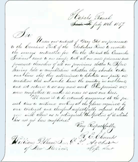
The Surveyor General of New Mexico granted this request. (National
Archives, Denver Branch)
|
|
|
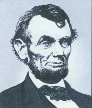
The Republican Party's 1860 presidential platform called for passage
of a homestead measure. With Abraham Lincoln's election and
the South's secession from the Union, Republicans made good on
their promise. Under the Homestead Act of May 20, 1862, heads of households,
widows, and single persons over 21 years old could apply for 160 acres subject to
entry under the Preemption Law. Patent for the land would be issued after 5
years of residence and cultivation or, if applicants so
chose, they could commute their claim before the end of 5 years to a
cash entry, paying the minimum price per acre.
|
|
The
Homestead
Act |
|
|
Abraham Lincoln (Jennifer Reese)
|
|
|
|
The Homestead Law was seen as a great democratic
measure by its supporters. The law, however, was but a promise; not
all could take advantage of it. The Homestead Law offered free land
but building of a home and breaking soil for crops took capital. The
environment also worked to defeat the dreams of many. Of the more than
1.3 million homestead entries filed before 1900, only about half would
go to patent.
|
|
Vision and
Reality |
|
|
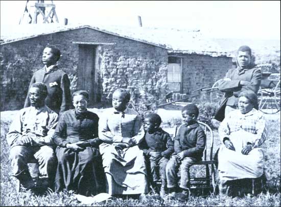
Homesteading in Nebraska in 1887 (Denver Public Library Western
History Collection)
|
|
|
TOWNSITE LAWS
|
|
|
Congress also turned its attention to townsites on
public lands. As early as 1824, counties were allowed to preempt a quarter section
(160 acres) of land for county seats. In 1844 towns founded on the public lands
were allowed to preempt up to 320 acres, and in 1864 and 1867 Congress
enacted new provisions that permitted towns to take title to even larger
areas. Most communities established on the public lands did not take
advantage of the townsite laws, but cities such as Denver, Boise, and
Carson City did.
|
|
Townsite
Laws |
|
MINERAL LAND POLICY
|
|
|
The discovery of gold in California in 1848 caught
the United States without a general mineral land policy, and Congress
took no immediate steps to institute one. Miners, who quickly spread
their search for precious metals across the Pacific Coast and Rocky
Mountains, were forced to develop their own laws and regulations.
Prospectors organized mining districts and devised rules as to how
claims were staked and "title" was held. These rules were then enforced
by miner courts.
|
|
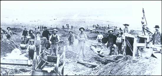
California
Gold Rush |
|
The government did have experience in dealing with
mineral lands. The Confederation had reserved a one-third interest in
all gold, silver, lead, and other minerals in the Land Ordinance of
1785. The federal government initially ignored the issue, only reserving
saline lands. But in 1807 it chose to reserve and lease public lands
valuable for lead in the Indiana Territory. The policy was extended to
Missouri and the Great Lakes region by 1816. The War Department, because
of the importance of lead in making rifle shot, administered the leasing
program, but found it could not cope with miners' resistance to
government oversight.
|
|
Early Mineral
Policy |
|
The leasing of lead deposits in Missouri ended in
1829. In 1845, President James Polk told Congress that the "system of
managing the mineral lands of the United States is believed to be
radically defective," costing the government more to administer than the
royalties it received. Congress agreed, and from 1846 to 1850, the lease
policy was abandoned in favor of the disposal of lead, copper, and iron
deposits in the Great Lakes region by preemption and sale.
Congress, however, avoided the mineral question in
the West. Presidents, Secretaries of the Interior, and General Land
Office Commissioners repeatedly asked for enactment of a policy—be
it lease, preemption, or sale—but Congress remained silent until
1866.
|
|
|
The first mining law was introduced by Senator
William Stewart of Nevada. As enacted, the Mining Law of 1866 declared
that "mineral lands of the public domain...be free and open to
exploration and occupation," and deal with the patenting of
lodes—claims containing gold, silver, or other precious metals
occurring in veins. Lode claims were subject to the customs and rules of
local mining districts, as long as they did not conflict with federal
law. The law also provided for the patenting of lode claims on which at
least $1,000 in actual labor and improvements had been completed. The
length of a claim could not exceed 200 feet and the miners could follow
the "dips, angles, and variations" of their lodes into adjacent
property. Metes-and-bounds surveys of the claims were to be made under
the direction of the Surveyor General, and the cost of patenting a claim
was $5 an acre.
|
|
Lode Mining
Law of 1866 |
|
In 1870, Congress passed a second mining statute,
this one pertaining to placer claims. The act defined placers as "all
forms of deposit, excepting, veins of quartz, or other rock in place."
Claims could be as little as 10 acres but no one person or association
of persons could have a single claim for more than a quarter section.
Claims had to conform with the legal subdivisions of the surveyed
townships, but metes-and-bounds surveys were allowed in unsurveyed
areas. The cost of patenting a placer claim was set at $2.50 an
acre.
|
|
Placer
Mining Law
of 1870 |
|
WILLIAM MORRIS STEWART -
"FATHER" OF THE MINING LAW
by William Condit
Mining Law and Salable Minerals, Washington Office
William M. Stewart (Jennifer Reese)
|
William Morris Stewart was the chief protagonist in
debates to secure passage of laws that recognized the governance system
miners had established by organizing into mining districts in the remote
and largely lawless West.
Born in upstate New York in 1827, Stewart turned to
study law in 1849 and went off to Yale to pursue a degree. He quit
school the next year to join the rush to the California gold camps.
There he engaged in gold mining, but with little success. Stewart again
turned to study law and was admitted to the California bar in 1852. Two
years later he became Attorney General of California.
In 1860, news of the fabulous silver discoveries on
the Comstock Lode drew him to Virginia City in the Nevada Territory. For
the next several years Stewart represented mining interests in fierce
litigation battles over possessory rights to portions of the Comstock
Lode. By all accounts he was domineering in the courtroom, a trait that
served him well later in life. (Stewart allegedly waved a gun while
interrogating a witness of "questionable veracity"!)
Based on his accomplishments in territorial politics,
Stewart was elected to serve as one of Nevada's first U.S. senators.
Stewart proved an eloquent "apologist" for lode and placer miners
occupying the public lands in technical trespass. Since no federal
statute authorized the settlement and mining of mineral lands, he
championed their system of self-governance. He believed "free mining" by
U.S. citizens should be encouraged by enactment of a law granting
patents to the discoverers of mineral wealth who diligently worked their
deposits under the rules of their mining districts.
After the Senate was persuaded, only the powerful
chairman of the House Committee on Public Lands, George Julian of Ohio,
stood between Stewart and passage of a lode law. Julian could bottle up
the bill in committee indefinitely. Stewart out-maneuvered his foe by
substituting his lode bill for one that had already passed the House,
dealing with rights-of-way for ditch and canal owners on public land.
Upon Senate passage, it was sent back to the House where Julian was
unsuccessful in having the bill referred to his committee. On July 28,
1866, the full House of Representatives passed Stewart's bill by a vote
of 77 to 34, a remarkable margin considering that most seats were held
by eastern congressmen who were expected to support legislation that
produced federal revenues from the public land.
In 1870, Stewart sought to persuade Congress that
placer miners on the public lands needed similar legislative recognition
of their possessory rights and an opportunity to patent their claims.
Julian continued to protest "free mining" policies but to no avail;
Congress went with Stewart's views again. On May 10, 1872, Congress
merged the lode and placer statutes and made technical amendments, such
as granting defined preemptive rights to lode claimants for the
discovered lode and the area of land flanking the lode.
|
|
|
Congress restated its mining policy in 1872 with the
passage of the General Mining Law. This law declared that "valuable"
mineral deposits rather than simply "mineral deposits" as stated in the
Lode Mining Law of 1866, were to be "free and open to exploration and
purchase." Local mining customs were still recognized. Lode locations,
however, could be no more than 1,500 feet long and 600 feet wide.
Furthermore, individual claimants were limited to 20 acres, while
associations or groups could still have 160-acre claims. To protect
their claims from others, claimants had to perform $100 of assessment
work yearly and show at least $500 worth of improvements before the
claims could be patented. Milling or processing sites could be entered
on nonmineral lands but could not exceed 5 acres. Survey requirements
and the per-acre cost of patenting a claim remained the same as
before.
|
|
General
Mining Law
of 1872 |
|
|
Placer Mining at Cripple Creek, Colorado in 1893 (State Historical
Society of Colorado)
|
|
|
The enactment of the mining laws transformed miners
from trespassers into legitimate occupants of the public lands. Valid
claims were given a status akin to private property. More important, the
development of minerals on the public lands was given priority over
other possible land uses.
In 1873 Congress provided for the sale of public
lands valuable for coal deposits. The law replaced an 1864 statute that
offered coal lands at auction for no less than $20 an acre and an 1865
law that permitted miners who had developed coal deposits prior to
enactment to preempt their mines. Neither law had been effective. The
new statute was intended as a remedy,
providing for the location, development, and preemption of 160 acres to
individuals and up to 640 acres to associations that had spent at least
$5,000 in development. The minimum price was set at $20 an acre if the
claim was within 15 miles of a railroad and at least $10 an acre, if
further out.
|
|
Coal Lands
Law of 1873 |
|
GEOLOGICAL SURVEYS
|
|
|
After the Civil War, Congress began funding scientific and geologic
explorations of the West to further encourage mineral development of
public lands. Ferdinand Hayden, Clarence King, Lieutenant
George Wheeler, and John Wesley Powell conducted expeditions
over large areas of the Great Plains, Rocky Mountains, and Great Basin, mapping the
terrain and describing the resources. In 1879, Congress consolidated
these independent efforts into one organization, the U.S. Geological
Survey.
|
|
Early
Exploration |
|
The Geological Survey was responsible for "the classification of the
public lands and examination of the Geological Structure,
mineral resources and products of the national domain." Under its first
Director, Clarence King, and his successor, John Wesley Powell,
the Geological Survey established itself as a competent, scientific
organization. Its studies
became highly valued by private industry and the General Land Office
came to depend on its geologic and hydrographic knowledge.
|
|
U.S.
Geological
Survey |
|
STATE AND RAILROAD LAND GRANTS
|
|
|
Congress shared the bounty of the public domain with
more than miners and settlers. Soon after passage of the Homestead Act,
it provided immense grants of lands to the states and railroad
corporations.
|
|
|
The Morrill Act of 1862 provided each state within
the Union 30,000 acres of public land for each senator and
representative to finance agricultural and mechanical arts colleges.
States with public lands chose the acreage from the public lands within
their boundaries. States having no public land, or little remaining
acreage, were given scrip. Scrip, which was issued in 160-acre
increments and sold to private parties by the states, could be used to
locate and pay for any nonmineral public lands open to sale or private
entry. From this grant, schools such as Cornell and Illinois State
University were established.
|
|
Public Lands
for Colleges |
|
By providing lands to the states for the
establishment of agricultural colleges, Congress was simply continuing
its tradition of granting public lands for schools. The Confederation,
in the Land Ordinance of 1785, had reserved Section 16 in each township
to finance public education in the Ohio Country. The federal government
reinstituted this practice when it admitted Ohio into the Union in 1802.
The practice was continued with other states, partly to placate them for
having to disclaim any right, title, or interest to the public lands
within their boundaries. After 1848, states received two sections of
land from each township, which increased to four sections with the
admission of Utah, Arizona, and New Mexico.
|
|
Early Grants
in Aid of
Education |
|
Congress also provided public lands to the states to
finance institutions such as schools for the deaf and blind, and prisons.
Most important to the economic development of the public land states
were the grants for internal improvements. Under the land grants, roads
and canals could be built and waterways improved. In 1841, Congress
granted each of the public land states 500,000 acres of land for such
purposes. Congress also gave lands classified as swamp and overflow to
various states prior to the Civil War.
|
|
Internal
Improvement
Grants |
|
The day before President Lincoln signed the Morrill
Act, he approved a law granting lands to aid the construction of the
first transcontinental railroad. Congress gave the Central Pacific and
Union Pacific railroad companies "every alternate section of public
land, designated by odd numbers, to the amount of five alternate
sections per mile on each side of said railroad, on the line thereof,
and within the limits of ten miles on each side of said road." In 1864,
the grant was increased to 20 alternate sections for each mile of track.
Lands reserved by the United States, to which a preemption or homestead
claim had been attached at the time the railroad's route was fixed, were
excluded, as were all mineral lands except those known to be chiefly
valuable for iron or coal.
|
|
First
Transcontinental
Railroad
Land Grants |
|
Before the Central Pacific and Union Pacific grant,
Congress had given public lands to the states to encourage railroad
construction. The practice began in 1850 with the Illinois grant for the
Illinois Central Railroad and extended to other states in the Midwest
and South in the decade that followed. But with few states between the
Missouri River and the Pacific Ocean, and a vast territory to be
crossed, a new policy for granting lands directly to railroad
corporations became necessary.
|
|
Early
Railroad
Land Grants |
|
|
Limits of the railroad land grants
|
|
|
The Central Pacific and Union Pacific grant was
followed by others. The largest went to the Northern Pacific Railroad
Company, which built a line from Lake Superior to Puget Sound. Northern
Pacific received 20 odd numbered sections for each mile of right-of-way
across states and 40 odd numbered sections for each mile across the
territories. The massive grant, if it had been entirely fulfilled, would
have provided 47 million acres of public land to the company, more than
twice the acreage provided for the first transcontinental route. From
1862 to 1871, Congress granted nearly 128 million acres to corporations
for the construction of railroads.
|
|
Northern
Pacific
Railroad
Land Grant |
|
These multimillion-acre "checkerboard" empires came
under criticism in the late 1860s. Many westerners raised the cry of
monopoly as railroads failed to bring their lands to market; the people
demanded that the public lands be reserved for actual settlers. They
called for an end to the grants and for the forfeiture of unearned and
unsold land grants. Congress responded at first by placing "homestead
clauses" on any railroad land grant legislation that required companies
to sell their grants in quarter-section tracts for $2.50 an acre to
actual settlers. After 1871, Congress refused all further railroad land
grants. Legislation on forfeiture came years later, but few land grants
were revoked as a result.
|
|
End of
Railroad
Land Grant
Policy |
| Selected Railroad Land Grants as of 1941 |
| Company | Acres |
| Central Pacific | 11,199,560 |
| Union Pacific | 19,156,460 |
| Santa Fe Pacific (Atlantic & Pacific) | 11,595,341 |
| Northern Pacific | 39,064,567 |
| Southern Pacific | 7,907,966 |
| Oregon and California | 2,777,632 |
|
|
|
NEW LAND LAWS FOR THE WEST
|
|
|
As if settlers did not already have enough
competition for public lands, Congress continued to auction lands after
passage of the Homestead Act. Congress ordered millions of acres to
market in Wisconsin, Nebraska, Kansas, California, and other states and
territories. Good agricultural lands were offered at many of these
auctions. But, after 1870, Congress was reluctant to put any more public
lands up for auction.
|
|
Land Sales
After
Homestead
Law |
|
The Congressional reluctance to sell public lands
coincided with an effort to expand settlement opportunities. By the
Timber Culture Law of 1873, 160 acres could be entered by anyone
interested in planting and growing trees on land naturally devoid of
timber. The Timber Culture Law responded to the common belief that trees
would bring rain to the semiarid West. Forty acres had to be planted in
trees, with the trees set no farther than 12 feet apart. No residence
was required and patent would pass if the trees had been kept in
"healthy, growing condition for ten years." Amendments
to the law in 1874 and 1878 reduced the acreage
planted to 10 acres and permitted patenting within 8 years.
|
|
Timber
Culture Law
of 1873 |
|
The Desert Land Law was passed in 1877. It applied to
public lands "exclusive of timber lands and mineral lands which will
not, without irrigation, produce some agricultural crop." Entry could be
made for a full section (640 acres), at a cost of $1.25 per acre, and
patents if irrigation was accomplished within 3 years. The law applied
only to the States of California, Oregon, and Nevada, and to the
Territories of Washington, Idaho, Utah, Dakota, Montana, Arizona, New
Mexico, and Wyoming. The State of Colorado was included in 1891. Like
the Timber Culture Law, no residence was required.
|
|
Desert Land
Law of 1877 |
|
Congress had enacted the Timber Culture and Desert
Land Laws to give settlers flexibility. Both laws recognized that the
public lands west of the 100th Meridian were semiarid in character and
that settlers needed more land than east of the meridian for successful
farming operations to be established. The laws allowed settlers to
acquire up to 1,120 acres when used in conjunction with the Preemption
and Homestead Laws.
|
|
Timber
Culture and
Desert Land
Law in
Operation |
|
Proving up—successfully patenting
lands—under the Timber Culture and Desert Land Laws, however, was
difficult. The Timber Culture Law, after its amendment in 1878, required
claimants who had entered 160 acres to have 6,750 trees in "living (and)
thrifty" condition at the end of 8 years. In the semiarid West this was
difficult to achieve, and only 65,000 of the 260,000 entries filed under
the law were patented under the tree planting provisions of the law.
Success under the Desert Land Law was little better.
Construction of irrigation works was expensive and most settlers found
they could not comply with the requirements of the law. Many settlers
responded to the situation by resorting to fraudulent methods of proving
up on their claims.
Fraud was also used with the Timber Culture and other
laws. The situation became so bad that much of the work in the General
Land Office became more and more concerned with the detection and
prosecution of fraudulent claims.
|
|
|
LAND FRAUD
|
|
|
Fraud, as stated previously, had been a problem since
the creation of the public domain. By the 1870s, evidence of the
illegal appropriation of the public lands and resources became
pronounced. In 1879, Congress created the first Public Lands Commission
to look into how the land laws might be revised but then paid little
attention to the recommendations.
|
|
First Public
Lands
Commission |
|
In his annual report for 1882, Commissioner of the
General Land Office Noah McFarland noted that investigations by his
bureau had found "that great quantities of valuable coal and iron lands,
forests of timber, and the available agricultural lands in whole regions
of grazing country have been monopolized." Mineral, livestock, and
timber companies had people make entries under the Preemption and
Homestead Laws and then purchased the claims after patenting
requirements had been met so they could amass large
landholdings. The Timber Culture Law was used by
speculators to secure interests in lands they knew later settlers would
buy. Stockraisers used the Desert Land Law to control access to streams
and rivers. They also fenced public lands to exclude other ranchers and
settlers from rangelands they used. In Colorado alone, 3 million acres
were fenced.
|
|
Commissioner
McFarland
and Land
Fraud |
|
THE BEAUBIEN-MIRANDA (MAXWELL)
MEXICAN LAND GRANT
By Andrew Senti
Realty Specialist, Colorado State Office
Editor's Note: The United States has, with each
acquisition of the public domain, recognized
land titles granted by the previous sovereign. Of the
thousands of private land claims and
grants patented, those in New Mexico and California
were the largest and among the most complicated to adjudicate.
The Beaubien-Miranda grant (within present Colorado
and New Mexico) had its origin in a brief period when the territory was
under Mexican rule. On January 8, 1841, a fur trader of French-Canadian
ancestry named Carlos Beaubien and Guadalupe Miranda, a Mexican citizen,
filed a petition with the Civil and Military Governor of New Mexico
asking for a grant of land that they promised to settle and develop. The
grant given to Beaubien and Miranda was the largest of several large
private land grants approved by Mexican officials in 1843-1844.
The grant consisted of a 1,714,765-acre tract of land
in the County of Taos. Its boundaries were described by a
metes-and-bounds description that used natural boundaries — streams,
mountain ranges, etc. A portion of the grant's boundary description went
as follows: "commencing below the junction of the Rayado and Red Rivers
from thence in a direct line to the east to the first hills from thence
following the course of the Red River in a northerly direction to the
junction of Una de Gato with Red River."
The grant to Beaubien and Miranda far exceeded the 11
square leagues (44,800 acres) allowed under Mexican law. In historical
perspective, these large, rather hastily processed grants appear to have
been an attempt to foster occupancy along the vulnerable northern and
eastern boundaries of the Mexican Territory and encourage settlement and
at least agricultural development.
Beaubian sold his half of the grant in 1858 to Lucian
B. Maxwell, an American who had married Beaubian's daughter in 1842. It
thereafter became commonly known as the Maxwell Grant.
By the Treaty of Guadalupe Hidalgo of 1848, the
United States acquired New Mexico and pledged to recognize the land
grants made by the Mexican government. The General Land Office
recommended patenting of the Maxwell Grant in 1857. Congress confirmed
the grant on June 21, 1860. but conflicting claims of interest in the
grant by others, delayed final confirmation of the grant by the U.S.
Supreme Court until 1887.
Perhaps some of the ordeal of confirming the Maxwell
and other land grants can be attributed to centuries-old Spanish
philosophy toward land tenure that clashed with Anglo-American
attitudes. Anglo-American thought leaned toward economic aspects, while
Spanish social and political thought valued land as a territorial
dimension of society. Anglo-Americans found this difficult to
understand.
|
|
COMMISSIONER WILLIAM A. J. SPARKS
CONFRONTS PUBLIC LAND FRAUD
Annual Report of the Commissioners of the General
Land Office, 1885
William A. J. Sparks (Jennifer Reese)
|
At the onset of my administration I was confronted
with overwhelming evidences that the public domain was being made the
prey of unscrupulous speculation and the worst forms of land monopoly
through systematic frauds carried on and consummated under the public
land laws.
In many sections of the country, notably throughout
regions dominated by cattle raising interests...entries were chiefly
fictitious and fraudulent and made in bulk through concerted methods
adopted by organizations that had parceled out the country among themselves
and inclosures defended by armed riders and protected against immigration
and settlement by systems of espionage and intimidation.
In other cases...individual speculation, following
the progress of public surveys, was covering townships of agricultural
land with entries made for the purpose of selling the claims to others,
or by entries procured for the acquisition of lands in large bodies. Again,
in timbered regions, the forests were being appropriated by domestic and
foreign corporations through suborned entries made in fraud and evasion of
law. Newly-discovered coal-fields were being seized and possessed in
like manner.
The question of my own duty, as the administrative
officer immediately charged under the law with seeing that the public
lands were disposed of only according to law, was at once forced upon
me. Should I continue to certify and request the issue of patents by
the President indiscriminately upon entries which there was every
reasonable ground to believe were fraudulent...or should I withhold
such final action until examinations could be made and the false claims
separated from those that were valid? Should I disregard cumulative
evidences of the universality of fraudulent appropriation of public
lands and become an official instrumentality of their consummation, or
should I say: "I mean to know what I am doing before I ask the President
of the United States to sign any more land patents?"
As a measure...of indispensable precaution I notified
the several divisions...that final action should be suspended upon
entries made in states and territories in which the greater degree of
fraud had been developed, and where the larger disposable area of public
lands remained.
This notification, or order, was not expected to be
acceptable to those whose purposes it is falsely and fraudulently to
acquire title to public lands, nor to those whose profitable vocation
was to promote the speedy obtainment of patents for compensation for
fee. It was a public measure in the public interest...intended to
check...conspiracies against the government.
I have caused lists of suspended entries to be
placed in the hands of special agents for examination and report,
and am convinced that it is not safe to issue patents or pre-emption,
commuted homestead, and other entries in which fraud most largely
prevails without such examination.
|
|
|
McFarland established a corps of agents to
investigate illegal entries and fencing. The new agents joined others
already assigned to investigating illegal timber cutting. These agents,
however, were few; a single investigator was often responsible for an
entire state or territory, limiting what could be accomplished. To help,
the Commissioner called for the repeal of the Preemption and Timber
Culture and the other land laws being fraudulently used. He also called
for enactment of an anti-fencing statute, the only request Congress
acted on.
|
|
|
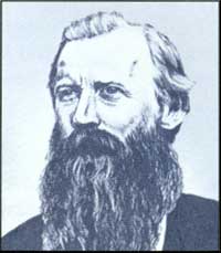
McFarland's successor, William A. J. Sparks,
continued the fight against fraud. Sparks saw illegality everywhere. To
combat it, he suspended all pending patent applications under the
various land laws and began reinterpreting the land laws and their
requirements to prevent their misuse.
|
|
Commissioner
Sparks and
Land Fraud |
|
The new Commissioner was joined in his crusade
against fraud. His New Mexico Surveyor General, George Julian, also
railed against illegal practices. Julian was particularly concerned
about private land grant claims made by Spain and Mexico. Charged with
adjudicating these claims, the Surveyor General of New Mexico found many
of the claims to be forgeries or excessive in the lands they
included.
The zeal of Sparks and his lieutenants brought
protests. The Cheyenne Sun in 1887 derided the Commissioner by
declaring that the West "shalt have no other god than William Andrew
Jackson Sparks, and none other shalt thou worship." Such protests became
too much for President Grover Cleveland and he eventually had to ask for
Sparks' resignation.
|
|
|
The efforts of McFarland and Sparks had a telling
effect on fraud. While not eliminating it, they reduced fraudulent
activity on the public lands. The two commissioners also clearly brought
the problem to the attention of Congress. Public land law reform was
needed, and Congress, always slow to react on land matters, did
eventually react. In 1890, individuals were restricted from acquiring
more than 320 acres of public land. Under the General Public Lands
Reform Act of 1891, Congress stopped auctioning public lands under the
Land Law of 1820, repealed the Timber Culture and Preemption acts
(though not without some saving clauses), and reduced Desert Land
entries to 320 acres.
|
|
Public Land
Law Reform |
|
LAND RUSH IN OKLAHOMA TERRITORY
by Anthony Rice
From OUR PUBLIC LANDS (Summer 1976)
Editor's Note: In 1889 the opening of Indian lands in
Oklahoma Territory to homesteaders began. Early openings provided
opportunities for settlers to race for homestead tracts. The last "rush"
came with the opening of the 6,500,000-acre "Cherokee Strip" in 1893.
Among the 45 clerks hired by the General Land Office to handle homestead
applications was Anthony Rice, who wrote the following account of his
experience of the Cherokee Strip.
It was a "Public Land Opening," in its wildest sense.
I will attempt to describe it as I saw [it] and as it in reality was.
In order to prevent parties who had no rights under
the homestead laws from entering the land and thereby defeat the chances
of those who were entitled thereto, the "booth" or registration system
was adopted. Accordingly, nine booths were established, five of which
were on the northern and four on the southern line of the [Cherokee
Strip].
The booths were open from September 11 to September
19, 1893, between the hours of 7 A.M. and 6 P.M. Over 115,000 persons
registered, while the lands fit for homesteading would provide for only
about 20,000.
I registered a blind man and in order to satisfy my
curiosity, I inquired of his guardian what possible chance the poor
fellow had in this wild scramble and how he proposed to make the race.
The guardian replied that he would stand him on the line and as soon as
the gun was fired, he would make one jump and plant his flag. I am
afraid that this fellow, if he got in front of that crowd, was himself
planted, instead of the flag.
The hardships endured were indescribable. Persons
slept on the line for two and three days, waiting to be
registered....And all this was endured for what? In the bare hope of
realizing that which is so characteristic of our present speculative
generation — the desire to get "something for nothing."
At high noon on September 16, 1893, the soldiers fired
their guns and off started the greatest and most wonderful race of all
times. About 150,000 persons went pell mell, helter skelter. Some went
on horseback, some in vehicles of every conceivable description, some by
train and some on foot.
The trains were loaded. Every inch of the roofs were
covered and many hung on the sides of the cars by holding to the window sills, while the
open windows furnished room for some.
You have often heard of doing a "Land Office
Business." We did it there.
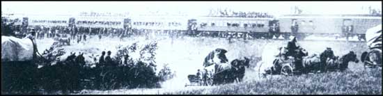
(BLM)
|
|
|
THE DWINDLING PUBLIC DOMAIN
|
|
|
By 1891, the public domain was rapidly diminishing.
In 1887, Congress, seeking to satisfy the nation's hunger for land, had
adopted a policy of giving individual farms to reservation Indians and
opening the remaining Indian lands to settlers. The Great Sioux Indian
Reservation in South Dakota, Chippewa lands in Minnesota, and the famous
"land rush" openings in Oklahoma, were among the many Indian
reservations opened to settlers. But the opening of Indian reservations
did little to alleviate the increasing demands.
|
|
Opening
Indian Lands |
|
Questions of how and to whom public lands would be
allocated became increasingly divisive; competing interests struggled to
gain control of the lands and resources they needed. This was
complicated by the federal government's more active role in
administering the use of public lands and resources, as the idea of
conservation began sweeping the nation.
|
|
|
THE COMING OF CONSERVATION
|
|
|
Early conservation efforts focused on public timberlands.
When Americans moved west from the Appalachian
Mountains pioneers gave little thought to conserving forests. Forests were an
impediment to progress. Trees were everywhere and made the clearing of land
for farming difficult.
|
|
Early
Attitudes
Toward
Timberlands |
|
The federal government disposed of these timberlands like any
others. Most forested areas east of the Mississippi River were sold at
auction. Agricultural lands with timber could be settled under
provision of the Preemption and Homestead Laws. In 1878, Congress
passed the Timber and Stone Law providing a quarter-section of land chiefly
valuable for timber or stone at the minimum cost of $2.50 an acre. Until
1892, the law applied only to California, Nevada, Oregon, and
Washington; afterwards it included all the public land states.
|
|
Timber and
Stone Law of
1878 |
|
Timberlands were quickly disappearing by the late 1800s. Many areas
around the Great Lakes had been clear cut and timber
production in the South was rapidly increasing. Fear arose that the
nation would soon have no more forests and calls for conserving what timberland remained began to
be heard.
|
|
Timber
Famine Scare |
|
The first response to this concern came with passage of the General
Public Lands Reform Law of 1891. The last section of the law allowed
the President to withdraw and reserve public lands "wholly or
in part covered with timber and undergrowth, whether of commercial
value or not" from settlement and location. The provision, which had been a
last minute amendment to the law and went forward without serious debate, was a
radical change from the disposal policies long followed by Congress.
|
|
Forest
Reserve Law
of 1891 |
|
No sooner had the 1891 law been enacted than President Benjamin
Harrison created the first "forest reserve" adjacent to Yellowstone
National Park. By 1893, 16 more reserves had been created, with nearly 18
million acres of public land set aside. Administration of
the forest reserves went to the Department of the Interior and the General Land
Office. Congress, however, failed to provide authority to administer use
within the forest reserves and Secretary of the Interior Hoke Smith
halted the creation of more reserves until Congress did so.
|
|
First Forest
Reserves |
|
After much debate, Congress passed the Forest Management Act of
1897. The law permitted the President to modify, suspend, and revoke
the forest withdrawals he made. It also gave the Secretary of
the Interior authority to regulate occupancy and use within the
reserves, develop mineral resources, provide for fire protection on the
reserves, and permit the sale of timber. Further, the law allowed owners of
private property within the reserves to exchange their lands for
nonmineral, public lands of equal acreage outside the withdrawals.
|
|
Forest
Management
Act of 1897 |
|
Administration of the reserves remained with the GLO,
which had a small corps of superintendents, supervisors, and rangers.
The GLO was assisted by the Geological Survey, which surveyed and mapped
the reserves, and the Department of Agriculture, which provided
scientific expertise on grazing and timber management matters.
|
|
|
THEODORE ROOSEVELT AND THE CONSERVATION ETHIC
|
|
|
Theodore Roosevelt became President after the
assassination of William McKinley in 1901. A New Yorker born to wealth,
Roosevelt had as a young man gone to the Dakota Territory and run a
cattle ranch. He had a great love of the outdoors and hunting. Under his
leadership, the federal government would mount a crusade for the
conservation of public lands and resources.
|
|
|
The central theme of Roosevelt's conservation
philosophy, according to Gifford Pinchot, chief architect of the policy
and first head of the Forest Service, was to provide "the greatest good
for the greatest number for the longest time." This called for
developing public lands in a manner that promoted the best and highest
use of resources, accomplished through scientific and technical
efficiency.
|
|
Roosevelt
Conservation
Philosophy |
|
Roosevelt's first conservation crusade involved
irrigation. Low precipitation mandated irrigation in many parts of the
West and Congress' enactment of the Desert Land Law of 1877 had been an
admission of this fact. In 1888 Congress, wanting to learn more about
irrigation possibilities in the West, ordered the Geological Survey to
investigate potential reservoir, ditch, and canal sites on the public
lands in the West, only to cancel the effort in frustration over the
slowness of the work.
|
|
Early
Irrigation
Policy |
|
The Carey Land Act of 1894 was then passed to
encourage state- and territorial-sponsored irrigation projects on public
lands. The states and territories could receive patent to any arid
public lands they had irrigated— up to 1 million acres. The
projects were to be constructed by private companies, but the lands had
to be sold in 160-acre tracts to actual settlers. The effort proved
disappointing, as few projects were built.
|
|
Carey Land
Act of 1894 |
|
To Roosevelt and other conservationists, irrigation
was a chance to make "worthless" lands valuable and to increase
agricultural opportunities. In 1902, the President and his supporters
pushed a reclamation law through Congress. The law provided for the
construction of federal irrigation projects in the western states and
territories, using proceeds from the sale of public lands. Lands
selected for reclamation were to be withdrawn from settlement but then
opened to settlers under the Homestead Law after the construction of
projects. No one person could receive more than 160 acres within a
project and settlers were to eventually repay the government for the
costs of construction.
|
|
Reclamation
Law of 1902 |
|
THEODORE ROOSEVELT ON CONSERVATION
Special Message of the President Transmitting
Report of the National Conservation Commission, January 22,
1909
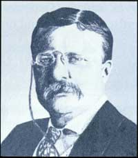
Theodore Roosevelt (Jennifer Reese)
|
The policy of conservation is perhaps the most
typical example of the general policies which this Government has made
peculiarly its own during the opening years of the present century. The
function of our Government is to insure to all its citizens, now and
hereafter, their rights to life, liberty, and the pursuit of happiness.
If we of this generation destroy the resources from which our children
would otherwise derive their livelihood, we reduce the capacity of our
land to support a population, and so either degrade the standard of
living or deprive the coming generations of their right to life on this
continent.
We should do all in our power to develop and protect individual liberty,
individual initiative, but subject always to the need of preserving
and promoting the general good. When necessary, the
private right must yield, under due process of law and with proper
compensation, to the welfare of the commonwealth...no man and no set of
men should be allowed to play the game of competition with loaded
dice.
All this is simply good common sense. The underlying
principle of conservation has been described as the application of common sense to
common problems for the common good.
Our public-land policy has for its aim the use of the
public land so that it will promote local development by the settlement
of homemakers; the policy we champion is to serve all the people
legitimately and openly, instead of permitting the lands to be
converted, illegitimately and under cover, to the private benefit of a
few. Our forest policy was established so that we might use the public
forests for the permanent public good, instead of merely for temporary
private gain. The reclamation act, under which the desert parts of the
public domain are converted to higher uses for the general benefit, was
passed so that more Americans might have homes on the land.
We are striving to add in all ways to the
habitability and beauty of our country. We are striving to hold in the
public lands the remaining supply of unappropriated coal, for the
protection and benefit of all the people. We have taken the first steps
toward the conservation of our natural resources, and the betterment of
country life, and the improvement of our waterways.
The nation, its government, and its resources exist,
first of all, for the American citizen, whatever his creed, race, or
birthplace, whether he be rich or poor, educated or ignorant, provided
only that he is a good citizen, recognizing his obligations to the
nation for the rights and opportunities which he owes to the nation.
The tasks this nation has to do are great tasks. They
can only be done at all by our citizens acting together, and they can be
done best of all by the direct and simple application of homely common
sense.
|
|
|
Soon dozens of federally sponsored irrigation
projects were underway in the West. Construction and management of the
irrigation systems went to the Reclamation Service, later renamed the
Bureau of Reclamation, but handling of Homestead entries remained with
the General Land Office.
|
|
|
Another of Roosevelt's public lands issues was the
resurgence of fraud. Ranchers were again fencing public lands;
speculation and fraud surrounded Homestead, Desert Land, and Timber and
Stone entries. The President created a second Public Lands Commission to
look into the problem.
|
|
Fraud
Resurgence |
|
The Commission, chaired by Gifford Pinchot, found the
public land laws "antiquated and ill-suited to conditions of the
remaining public domain." It called for changes in the Homestead and
Desert Land Laws to prevent fraud and asked that the Timber and Stone
Law be repealed because timber companies were using it illegally to
acquire large forest holdings. A few of the recommended changes were
enacted by Congress, but Roosevelt had to largely rely on the GLO's
corps of investigators to reduce fraudulent and illegal activity.
|
|
Second Public
Lands
Commission |
|
President Roosevelt pushed other conservation
measures with greater success. In 1905, he stepped-up creation of
wildlife reserves (establishing more than 50 by the end of his term),
and created the Forest Service within the Department of Agriculture to
administer the forest reserves (soon after renamed national forests). He
began the withdrawal of lands from settlement thought to be valuable as
sites to build dams for the generation of electrical power. The
President also pushed passage of the Antiquities Act of 1906.
|
|
Roosevelt's
Conservation
Initiatives |
|
The Antiquities Act provided for the protection of
historic and prehistoric objects on public lands. Any "historic
landmarks, historic and prehistoric structures, and other objects of
historic or scientific interest" were to be designated as national
monuments. Roosevelt created the first national monument that year with
the withdrawal of Devils Tower in Wyoming. Ten years later, 35 natural
areas and prehistoric sites, ranging from one-half acre to nearly
300,000 acres, had been set aside.
|
|
Antiquities
Act of 1906 |
|
The General Land Office was given the responsibility
to manage and protect the national monuments, but Congress never
appropriated the needed funds. In 1916, administration of the monuments
was transferred to the newly created National Park Service, which also
took over management of the national parks from the Secretary of the
Interior.
|
|
National
Monuments |
|
COAL AND OTHER MINERAL POLICIES
|
|
|
Another of Theodore Roosevelt's conservation concerns dealt with the
mineral values of the public domain. Much of his attention focused on
coal; vital to the nation's industrial economy and the heating of
homes.
|
|
|
Fraudulent acquisition of coal lands had been a problem for years; to
stop the problem, Roosevelt wanted to withhold these lands so the
Geological Survey could determine whether the lands were more valuable
for coal than for other purposes. The President did this in 1906.
Roosevelt, however, had no explicit authority from Congress to
make such withdrawals, but he did contend, that as chief executive, the
President could do whatever was necessary in the interest of the people,
as long as the Constitution did not specifically prohibit it. Many in
Congress disagreed with this rationale; but a year after Roosevelt left
the White House, Congress enacted the General Withdrawal or Pickett Act
of 1910, giving the President power to "temporarily" withdraw public
lands from settlement and location for public purposes.
|
|
Roosevelt's
Coal Lands
Policy |
|
The coal land withdrawal action, which embraced more
than 66 million acres by November 1906, shocked western politicians and
business interests. They clamored for revocation of the withdrawals,
claiming that withholding coal lands from development would result in
winter coal shortages and that the withdrawals kept lands from
homesteaders.
|
|
|
To solve the problem, the President advocated
settlement if the coal could be reserved to the government. On the last
day of his presidency, Roosevelt signed the Act of March 3, 1909, which
provided patents to homesteaders who had settled previously unclassified
coal lands, as long as they consented to the United States' reservation
of the coal. The Act of June 22, 1910, permitted homesteaders to file
for known coal lands under the same condition.
|
|
Reserving
Coal to the
U.S. |
|
The policy of reserving mineral rights was also
extended to petroleum lands by Roosevelt's successors. Public land
valuable for oil could be patented under the placer mining law; to
protect that resource, President William Howard Taft in 1909 began to
withdraw suspected petroleum lands from agricultural entry. In 1912,
Congress permitted nonmineral entries on oil and gas lands in Utah, as
long as those minerals were reserved to the United States. Two years
later, during Woodrow Wilson's administration, the policy was extended
to all public lands and the list of minerals that could be reserved was
enlarged to include phosphate, nitrate, potash, and asphaltic
minerals.
|
|
Reserving Oil
and Gas to
the U.S. |
|
As part of the mineral policies initiated during his
Presidency, Roosevelt had advocated a leasing policy for coal and
petroleum lands, but Congress resisted the idea. In 1917, potassium
deposits could be leased because potassium was essential to America's
production of military explosives during World War I. This prompted the
policy to extend leasing to coal, petroleum, natural gas, sodium,
phosphate, and oil shale in 1920.
|
|
Mineral
Leasing
Debate |
|
Under the Mineral Leasing Act individuals and
companies could prospect for and develop the minerals listed.
Preference-right leases were issued to those who discovered previously
unknown deposits or were able to develop deposits previously thought
unworkable into marketable minerals. Competitive leases were issued for
public lands known to have valuable mineral deposits. Of the royalties
received by the United States from production of minerals under these
leases, 10 percent went to the U.S. Treasury, 37-1/2 percent to the
states in which production occurred, and the remainder to a fund for the
construction of federal irrigation projects.
|
|
Mineral
Leasing Law
of 1920 |
|
The law was administered among three Interior
Department agencies. The Geological Survey, through its Land
Classification Branch (later renamed the Conservation Division) classified public lands according to
mineral value. The General Land Office issued leases and collected fees
and royalties, and the Bureau of Mines oversaw lease development.
|
|
|
HISTORY OF THE U.S. GEOLOGICAL SURVEY'S CONSERVATION DIVISION
by Larry Godwin
Geologist, Washington Office
On March 3, 1879, Congress established the U.S.
Geological Survey (USGS) in the Department of the Interior and charged
it with the responsibility for classifying public lands and examining
the geologic structure and mineral resources and products of the
national domain.
Conservationists were becoming increasingly alarmed
over the waste of coal and other mineral resources caused by poor mining
methods and apathy toward conserving nonrenewable resources. During the
1890s many large companies fraudulently obtained coal land by paying
others to homestead lands having coal in the subsurface. Most of the
western coal fields were unmapped and had not been classified.
Accusations of fraud increased until, in 1906, President Theodore
Roosevelt ordered coal basins in the western United States withdrawn
from agricultural entry until they could be classified. That same year
the USGS began mapping and classifying coal fields on the public lands,
establishing the Land Classification Board to oversee the efforts.
In 1920, Congress passed the Mineral Leasing Act
which changed the disposal of oil and gas, coal, and other minerals to
leasing. The Bureau of Mines was given full responsibility for managing
oil and gas leasing operations. In 1922, Interior Secretary Albert B.
Fall approved the issuance of leases in the Teapot Dome Naval Petroleum
Reserve without competitive bidding. Congressional investigations
revealed that Fall had accepted money in return for the leases. As a
result of this scandal, Fall's successor, Hubert Work, in 1925,
transferred the mineral-leasing responsibilities to the USGS.
The Conservation Branch was established to
incorporate these new functions with the Land Classification Board. It
was authorized to classify lands according to their highest use; protect
the public interest in undeveloped minerals, water power, and
agricultural resources; and promote economical and efficient development
of mineral deposits on public and Indian lands. In 1948, the
Conservation Branch became the Conservation Division.
The Outer Continental Shelf (OCS) Lands Act extended
the jurisdiction of the United States to include the continental shelf
outside the 3-nautical-mile zone. The act authorized the Secretary of
the Interior to grant OCS mineral leases through competitive bidding. In
1953, the Division became responsible for OCS mineral exploration and
development.
By 1970, the Conservation Division was responsible
for (1) managing exploration and development of OCS minerals; (2)
classifying federal onshore lands as to their mineral and water power
value and managing exploration and development of minerals on federal
and Indian leases; and (3) collecting royalties from federal and Indian
leases.
The Nixon, Ford and Carter administrations considered
merging BLM, the Forest Service, and the Conservation Division into one
agency. Finally, on January 19, 1982, the Reagan Administration
established the Minerals Management Service (MMS) and transferred to it
all functions of the Conservation Division. On December 3, 1982, all
MMS's onshore minerals management functions were transferred to BLM.
|
|
|
HOMESTEADING AND CONSERVATION
|
|
|
The Conservation Movement did not mean that the
nation's settlement policy for the public lands had come to an
end—far from it. The country's commitment to providing farms to the
landless is well illustrated by the Reclamation Act of 1902 and other
acts.
|
|
|
The Forest Homestead Law of 1906 opened agricultural
lands within the forest reserves to settlement.
|
|
Forest
Homestead
Law of 1906 |
|
The most significant settlement law passed during the
Roosevelt years, however, was the Enlarged Homestead Law. The new law
responded to the dryland farming movement that grew soon after the turn
of the century. Lands previously thought to be valuable only for grazing
now became valuable for agriculture as farmers adopted techniques of
deep plowing, soil compacting, summer fallowing, and seeding
drought-resistant crops. Dryland farming, however, required greater
capital investment and more land.
|
|
Enlarged
Homestead
Law of 1909 |
|
The Enlarged Homestead Law gave 320 acres to farmers
who entered public lands that could not be irrigated. As with the 1862
Homestead statute, homesteaders had to reside on the land. One-eighth
the area entered now had to be planted, whereas the 1862 statute had no
specific requirement and settlers who had made 1862 Homestead entries were
permitted to make additional entries that would increase their total
holdings to 320 acres. Representatives from California, Idaho, Kansas,
North Dakota, and South Dakota originally asked that the law not be
extended to the public lands within their boundaries, but by 1915, the
new law, in one form or another, had been extended to those states as
well.
Congress further liberalized the homesteading laws in
1912 with passage of the Three-Year Homestead Law. This law reduced the
5-year residence and cultivation requirements to 3 years.
|
|
Three-Year
Homestead
Law of 1912 |
|
The Enlarged Homestead and Three-Year Homestead Laws
further stimulated a homestead rush already underway in the West because
of dryland farming promotion, increased precipitation, rising land
values, and escalating agricultural commodity prices. Millions of acres
were turned by the plow and new communities sprang up across the West.
In Montana, the Enlarged Homestead Law pushed entries from the 7,500
filed in 1909 to nearly 22,000 the following year. The crush of
settlement activity led to more Homestead entries being patented after
1900 than before.
|
|
Homestead
Boom |
|
The rush for homesteads, however, ended with
America's entrance into World War I in 1917. Many homesteaders were
drafted into the military, while others left to take well-paying
industrial jobs in the cities. After the war the bust continued as
drought swept across many parts of the West and agricultural and
livestock economic prices collapsed.
|
|
Homesteading
Bust |
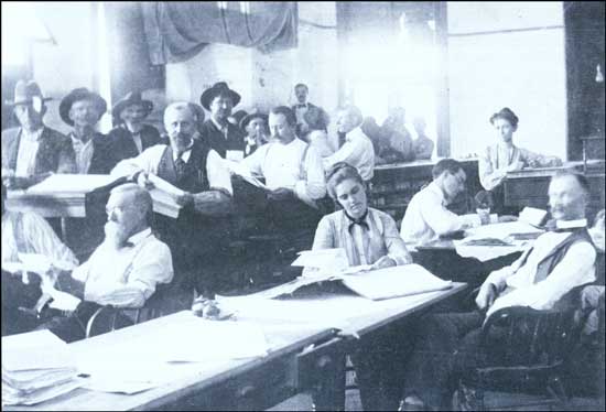
|
|
The El Reno District Land Office, Oklahoma Territory, 1901
|
|
|
THE PUBLIC LANDS GRAZING ISSUE AND PASSAGE OF THE TAYLOR GRAZING ACT
|
|
|
Another reason that homesteading dwindled after World
War I was the fact that the public domain had little good agricultural
land remaining. Excluding Alaska, there was little more than 200 million
acres of vacant, unappropriated, and unreserved public land remaining.
Much of the land was located in the eleven westernmost states, and most
of it was described by the General Land Office as arid, broken,
mountainous, or grazing in character.
|
|
|
It would be wrong to call this remaining acreage, as
so many have, the "land no one wanted." Many western ranchers still
depended on the remaining public domain to support their herds. They had
no right to these lands, but used the range for all it was worth. "It
was," as the Forest Service's Chief of Grazing, Will C. Barnes, put it
in 1926, "a clear case of first come, first served and the devil take
the hindmost." Never assured use of the same range year after year,
ranchers crowded and allowed overgrazing of public lands and, by doing
so, were destroying the foundation upon which their ranches were
built.
|
|
Grazing the
Commons |
|
Crowding and overgrazing the public domain had been a
long-term problem for the western livestock industry. As early as the
1870s, there was more livestock than the range could provide for. Cattle
ranchers first tried to use livestock associations and organized
roundups to control the situation. The coming of sheepherders and
farmers, however, complicated matters. Ranchers, as pointed out earlier, began
fencing the range with barbed wire to keep others out and gain control
of scarce water sources through the use of fraudulent land entries. The
federal government, however, ordered the fences down and investigated
the illegal claims.
The root of the ranchers' problem was that the
federal government was not meeting their needs. Stockraisers had to have
more than 160 acres of range for their herds. By 1900, some ranchers
were advocating a grazing lease system for public lands, and in 1905,
Theodore Roosevelt's Public Lands Commission seconded the
recommendation. Opposition to the proposal was strong and Roosevelt's
effort to enact such a law in 1907 was rejected by Congress.
|
|
|
In 1916, Congress decided that the answer to the
public lands grazing problem was not leasing but larger homesteads. The
Stockraising Homestead Law allowed individuals
to enter 640 acres (one section) of
public land chiefly valuable for
grazing and the cultivation of forage crops.
Settlers had to reside on the land
and make improvements equal to a $1.25 an acre. All coal and other
minerals were reserved to the United States.
Those who had already made entry under other
homestead laws could make additional entries until their holdings equalled 640
acres.
|
|
Specialized
Homestead
Law of 1916 |
|
The new law offered great hope. In its first year of
operation, about 60,000 applications were filed for some 20 million
acres of public land. Most of the entries, however, had to be suspended
until the public lands could be classified as to their character as
grazing lands.
Within a few years, attitudes had changed.
Agricultural economists agreed that a section of land was inadequate to
support enough livestock for a family ranch. By 1923, the General Land
Office contended that few making entry under the law could comply with
the law's requirements in good faith. Another policy was needed.
Grazing policy debate in the 1920s focused on a
leasing system for the public domain. As important as the question of what
type of lease arrangement would be provided was
the question of who would administer the policy: the Department of the
Interior or the Agriculture Department. Rivalry between the departments was keen, but in 1924
Interior gained the edge after the Forest Service alienated ranchers with
a proposal to raise national forest grazing fees.
|
|
Department
Rivalry |
|
In 1928, Congress established the Mizpah-Pumpkin
Creek Grazing District in southeastern Montana under the direction of
the Interior. The reserve comprised just over 100,000 acres of federal,
state, Northern Pacific Railway Company, and private lands. Congress provided for
the leasing of public lands to an association of ranchers who proposed
to block ownership and ensure conservative grazing. Congress hoped this
experiment would indicate the policy direction they should pursue.
|
|
Mizpah-
Pumpkin
Creek
Grazing
District |
|
Before the Mizpah-Pumpkin Creek Grazing District
could do that, however, President Herbert Hoover proposed giving the
remaining vacant, unappropriated, and unreserved
public lands to the states. Hoover felt the states could better manage the remaining public domain
and in 1930 established a Committee on the Conservation and Administration of
the Public Domain. In its 1931 report, this third public
lands commission supported the Hoover initiative, and called for the
cession of the public lands. Overwhelming opposition to the proposition,
both in the East and the West, killed the recommendation.
|
|
Third Public
Lands
Commission |
|
The rejection of the Hoover proposal gave the leasing
idea new life. The Mizpah-Pumpkin Creek Grazing District was so
successful, that ranchers from across the West petitioned Congress and
the Department of the Interior to create similar grazing reserves in
their areas. Supporters of leasing, however, wanted a law that applied
to all public lands.
|
|
Grazing Issue
Debate |
|
Led first by Congressman Don Colton of Utah and then
by Congressman Edward Taylor of Colorado, general grazing lease bills
were introduced, but opposition to them was strong. The deadlock was not
broken until 1934, when Secretary of the Interior Harold Ickes
threatened to withdraw the public lands and begin regulating grazing
under his own authority. This, along with a worsening drought in the
West, forced the opposition to capitulate. In signing the Taylor Grazing
Act, President Franklin D. Roosevelt declared it "a great forward step
in the interests of conservation, which will prove of benefit not only
to those engaged in the livestock industry, but also the nation as a
whole."
|
|
|
The Taylor Grazing Act sought "to stop injury to the
public grazing lands [excluding Alaska] by preventing overgrazing and
soil deterioration; to provide for their orderly use, improvement, and
development; [and] to stabilize the livestock industry dependent upon
the public range" through lease of the public domain to stockraisers.
Pending the "final disposition" of the public lands, the Secretary of
the Interior was permitted to place 80 million acres of public land
chiefly valuable for grazing and forage crops into grazing districts.
Section 3 of the law provided for the lease of grazing district lands to
landowners and homesteaders in or adjacent to the reserves first and the
issuance of 1 to 10 year leases. The public lands within grazing
districts were withdrawn from nonmineral entry, but lands classified as
valuable for agricultural development under Section 7 could, at the
Secretary's discretion, be opened to homesteading. Private lands within
the grazing reserves could be exchanged for outside public lands.
Isolated and disconnected tracts of public land no larger than 640 acres
could now be sold to facilitate district administration, an effort to
consolidate federal and private land holdings. Public lands outside
grazing districts could, under Section 15, be leased to ranchers with
contiguous property.
|
|
Taylor
Grazing Act
of 1934 |
|
After signing the law, President Franklin D.
Roosevelt withdrew from nonmineral entry all vacant, unreserved, and
unappropriated public lands in the West so that grazing districts could
be set aside and the remaining public lands classified as to their best
use.
|
|
|
THE TAYLOR GRAZING ACT AND THE DIVISION OF GRAZING
|
|
|
Secretary of the Interior Harold Ickes created a Division of Grazing
within his department to administer the grazing districts created under
the Taylor Grazing Act. To head the division, he selected Farrington
"Ferry" Carpenter, a northwestern Colorado rancher who had studied law at
Harvard and Princeton.
|
|
Division of
Grazing |
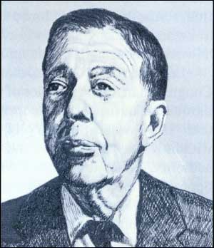
|
|
Farrington Carpenter (Jennifer Reese)
|
|
|
|
Immediately after his appointment, Carpenter set up a series of local
and state meetings with ranchers and state officials to discuss grazing
policy and to determine grazing district boundaries. The first district
was established in Wyoming on March 20, 1935. Others followed in
California, Colorado, Idaho, Montana, Nevada, New Mexico, Oregon, and
Utah. By June 1935, more than 65 million acres had been incorporated
into grazing districts.
|
|
Creating
Grazing
Districts |
|
Ranchers recommended the establishment of 50 grazing
districts covering 142 million acres, 62 million more than authorized
under the Taylor Grazing Act. Congress consented to this recommendation
in 1936. Eventually, the acreage limitation was entirely eliminated.
|
|
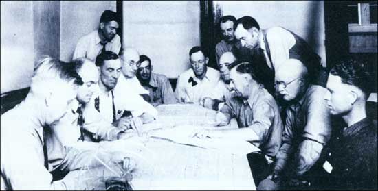
|
|
New Mexico Grazing District No. 6's advisory board
allocating use of the public range in 1936. (BLM)
|
|
|
With the creation of grazing districts, rules and
regulations to control grazing use had to be promulgated. In granting
grazing permits to ranchers, the first priority was to those who had
adequate private land to support their herds when not using the public
range and who had a history of range experience. Others would be given
permits using criteria that weighed property ownership and traditional
use. For the privilege of using the public lands, ranchers and
sheepherders were assessed a fee of 5 cents per animal
unit month (AUM), which was judged to be the cost of
feeding one cow, one horse, or five sheep for 1 month.
|
|
Determining
Range Use |
|
To help administer the grazing districts, Carpenter
set up district advisory boards. From these boards, he sought advice and
recommendations on district grazing boundaries, range conditions, and
the apportionment of public rangelands among users. This "home rule on
the range" was successful and ensured the cooperation and help of
ranchers in implementing the Taylor Grazing Act.
|
|
Grazing
Advisory
Boards |
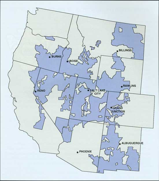
|
|
Taylor Grazing Districts (January 1937)
and regional offices
|
|
|
Congress gave the district advisory boards legal
status in 1939. The following year, a National Advisory Board Council
composed of district board representatives was organized, and later state
advisory boards came into being.
|
|
|
In administering the grazing districts, Carpenter
sought both to conserve and to restore the range. To do this, he
enlisted the assistance of the Civilian Conservation Corps (CCC). The
CCC workers developed watering sources to more evenly distribute
livestock on the range and erected fencing for better range management.
CCC crews also worked on rodent and insect control, soil erosion
measures, and fought fires.
|
|
CCC and the
Public Range |
|
Secretary Ickes, who had disliked Farrington
Carpenter from the beginning, finally fired him in 1939 and replaced him
with Richard H. Rutledge. Under the new director, a former Forest
Service employee, the Division of Grazing was renamed the U.S. Grazing
Service and its headquarters transferred to Salt Lake City in 1941.
|
|
|
ADMINISTRATIVE PRINCIPLES OF THE GRAZING
SERVICE
by Richard Rutledge
Director, U.S. Grazing Service
Editor's Note: Grazing Service Director Richard
Rutledge sought to establish an effective conservation agency. To
achieve this, he set forth principles of conduct for his District
Graziers. Here are some of the principles.
SELF-RELIANCE—There is often the tendency upon
receiving a tough assignment to push it aside and wait until you can ask
the boss a lot of questions concerning the way he wants the job done.
This results in procrastination and in a leaning attitude on the part of
the doer. Stand on your own feet and take responsibility.
ORGANIZATIONAL ATTITUDE—No organization can be
successful if cliques or jealousies exist. These things tend to retard
and to break down the spirit of the organization. Likewise, feuds and
personal fights are extremely detrimental and are bound to react upon
someone. Troublemakers have no place in the organization. Rating officers
must take recognition of such things. The ability to get along with and
work with others, and the attitude toward others, are important factors
in efficiency determination.
PUBLIC SERVICE—Let's get firmly fixed in our
minds at the outset that we are public servants, employed by the public
and paid by the public from funds provided by taxation in some form. We
are responsible to the entire public and are not bureaucratic bosses to
work our will upon the public as we see fit.
SHARP PRACTICES—There can be no place in an
administrator's thoughts or actions for anything that approaches sharp
practices. Stockmen are usually not as well informed as the
administrator. Many times they are trusting, depending upon the
administrator. There should be no tendency toward scheming around or
taking advantage of lack of information or ignorance. Your actions
should always be square, with equity and fairness.
MIXING—This is somewhat akin to friendliness,
although it goes farther. It is very necessary that an administrator mix
with or contact all kinds of people, meetings, associations, church
groups, and others. Be a part of the community.
SELF-JUSTIFICATION—One of the very worst habits
that an administrator can fall into is that of trying to justify his
actions under all circumstances. If an administrator has made a mistake,
the thing to do is to face the situation and correct the action. An
administrator can lose the respect and confidence of his users very
quickly by adopting an attitude of self-justification.
CAPRICIOUSNESS—The administrator should avoid
actions which might be termed capricious. Any funny notion or foolish
idea, or snap judgement, may take the turn of capriciousness. Keep your
feet on the ground and remember that you are business men [sic], doing
business.
|
|
|
THE TAYLOR GRAZING ACT AND THE GENERAL LAND OFFICE
|
|
|
The Taylor Grazing Act gave the General Land Office
new responsibilities. Its previous function had primarily been to
dispose of public lands and minerals. Now the GLO had authority to
manage these resources.
|
|
|
The Secretary of the Interior gave the GLO
responsibility for administering the leasing of rangelands outside the
grazing districts as provided by the Taylor Grazing Act. It also handled
all land exchanges, land sales, settlement entries, and mineral leasing
within the grazing districts. The largest responsibility given to the
GLO, however, was the classification of public lands to further the
conservation and development of public land resources outside grazing
districts.
|
|
New
Responsibilities |
|
President Franklin D. Roosevelt's executive order of
November 1934 directed that all remaining public lands in Arizona,
California, Colorado, Idaho, Montana, Nevada, New Mexico, North Dakota,
Oregon, South Dakota, Utah, and Wyoming be temporarily withdrawn,
investigated for possible inclusion in grazing districts, and classified
for agricultural values. Public lands could not be allocated until their
best and highest use had been determined. In February 1935, the order
was extended to include public lands in the states of Alabama, Arkansas,
Florida, Kansas, Louisiana, Michigan, Minnesota, Mississippi, Nebraska,
Oklahoma, Washington, and Wisconsin.
|
|
FDR's
General
Withdrawal
Order |
|
The move toward conservation required a major
reorganization of the GLO. It was no longer just a disposal agency. A
Range Development Service was created in 1939 to plan and oversee
construction of range improvements. The inventory and classification of
public lands went to a Branch of Planning, Use, and Protection, while a
Branch of Research and Administration aided conservation efforts by
abstracting agency land records so that federal land and mineral
interests could be identified. Transfer of the Interior Department's
Division of Investigations to the GLO in 1942 enabled the agency to
better investigate illegal use of public lands.
|
|
GLO
Reorganization |
|
THE OREGON AND CALIFORNIA REVESTED LANDS
|
|
|
The Oregon and California Revested Lands Sustained
Yield Management Act of August 28, 1937 gave the General Land Office
even more conservation responsibilities. The revested lands had been
granted in 1866 to the Oregon and California (O&C) Railroad Company
for construction of a line from Portland to the California border.
Congress stipulated in 1869 that the 3.7 million acres granted the
railroad had to be sold in tracts no larger than 160 acres to actual
settlers and for no more than $2.50 an acre. The company and its
successors ignored the conditions; so, in 1916, after lengthy
litigation, Congress revoked title to more than 2 million acres of the
grant. In 1919, the federal government reclaimed another 93,000 acres
from the nearby Coos Bay Wagon Road Grant.
|
|
O&C
Railroad
Grant |
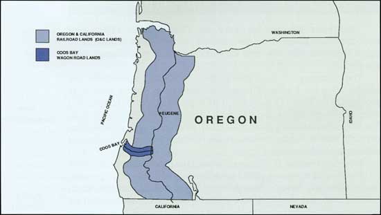
|
|
Revested lands of the Oregon and California Railroad and the Coos Bay
Wagon Road
|
|
|
The revested lands had some of the best timber stands
in the United States. Naturally, the Forest Service wanted jurisdiction
over the former land grant lands, but Congress gave it to the General
Land Office because of the ill will Oregonians had toward the Forest
Service. The GLO's mandate was to classify the revested lands in terms
of their value for power sites, agriculture, or timber. Lands were then to
be disposed of accordingly, although, trees on timberlands had be cut
before the land itself was sold. Revenues from the lands and timber sold
were to be divided among the federal government, Oregon, and the
counties in which the lands were located.
|
|
Early
Administration
of the O&C
Lands |
|
The GLO immediately began classifying the O&C
lands with a small staff of surveyors and timber cruisers. As
timberlands were identified, they were offered for sale at auction to the highest
bidders, who then had 10 years to cut the timber. Timber sales were
disappointing over the next 20 years and the GLO came under increasing
criticism for its management of the area.
The Oregon and California Revested Lands Sustained
Yield Management Act of 1937 sought to enhance the GLO's administration
of the O&C lands. The law called for implementation of a sustained
yield cutting program (lumber production would not exceed forest
regeneration), so that continuous forest production could be assured.
Lands could be used for grazing and recreation, and watersheds,
wildlife, and other resources were to be protected. Receipts from the
sale of timber were generously shared with counties having O&C
lands.
An O&C Revested Lands Administration was placed
under the General Land Office in 1938 to implement the act, and Walter
Horning was appointed chief forester. Under his guidance, district
offices were established, timber cutting regulations written,
rights-of-way acquired, and timber inventory work begun.
Along with the establishment of the O&C
Administration, Secretary of the Interior Harold Ickes appointed an
O&C Advisory Board. The board represented state government, county,
lumber, and public interests and advised the O&C Administration's
chief forester on policy matters. District advisory boards were also
established.
To supplement the O&C Administration's meager
budget, several Civilian Conservation Corps camps were assigned to the
revested lands. CCC enrollees constructed roads, planted trees, worked
on insect control, and fought fires. This work did much to conserve and
improve the management of O&C lands.
|
|

|
|
Civilian Conservation Corps Camp in the O&C area of Oregon (BLM)
|
|
|
PUBLIC LAND POLICY IN ALASKA
|
|
|
The General Land Office's new conservation program
also included public lands in Alaska. Alaska was truly
the United States' last frontier; the region had long been ignored, and little of its 378
million acres developed. Alaska was a land apart. None of the public land laws
of the contiguous United States applied to Alaska, unless expressly
provided.
|
|
Land Apart |
|
There had been no public interest in acquiring Alaska
before its purchase in 1867. After the area was bought a few
hardy Americans rushed north to take advantage of
whatever opportunities the new territory might offer. Commissioner of
the General Land Office Joseph S. Wilson spoke of Alaska's potential in
1868. He estimated 150,000 acres of good agricultural land existed and
noted deposits of gold, silver, copper, coal, and other minerals. Wilson
recommended that the public land system be extended to Alaska so
"settlers, present and prospective, may enjoy the privileges similar to
those conceded to our people elsewhere in the public domain."
|
|
Acquisition |
|
Congress paid no attention to Alaska until the
discovery of gold in the early 1880s. The Act of May 17, 1884 extended the
mining laws to the region and established a local
land office to handle mining claim patent applications. That was,
however, all Congress chose to do, for it then declared that "nothing
contained in [the] Act shall be construed to put in force in said
district the general land laws of the United States."
|
|
Mining Laws |
|
Two years later Commissioner of the General Land
Office William A. J. Sparks still saw no need to change the situation.
"No information," he pointed out, "indicates either
the necessity or expediency of extending the
public land laws over the territory at present."
Sparks noted that only one mineral application had been filed
and the value of Alaska's agricultural
lands was questionable. He felt it best to hold the
region for future occupation. Congress agreed, but did in 1891, provide
for the establishment of townsites and 160-acre trade and manufacturing
sites.
|
|
Townsite and
Other Laws |
|
The Klondike discovery in 1896, which brought
thousands of gold seekers north, forced Congress to extend other
public land laws to Alaska. The Act of May 14, 1898 granted
railroad rights-of-way, allowed timber
cutting, and permitted entry of 80-acre tracts under the
Homestead Law. The public land survey system was extended to the
region in 1899, and the year after that, the Coal Land Law of 1873 was also
implemented.
|
|
Homestead and
Other
Laws |
|
The new laws had little impact on Alaska. By 1914,
fewer than 200 Homestead applications had been filed and little of
the territory's coal had been mined. To encourage the settlement and
development of Alaska, Congress that year funded construction of a railroad from
the Pacific coastline to Fairbanks and provided for the lease of
coal deposits. Neither action achieved the intended result; however,
construction of the Alaska Railroad, completed in 1923, did lead to the founding
of Anchorage.
|
|
Alaska
Railroad |
|
The federally sponsored Alaska Resources Committee
reported to Congress in 1938 on the resources and potential development
of the territory. Committee members pointed out that there was no
population pressure nor raw resource demand requiring rapid development.
Alaska's resources, however, did need protection until
development. This was particularly true for timber and the committee
stated that "establishment of a fire-protection organization on the open
public domain [was] an essential first step in...bringing the
public-land resources under a reasonable degree of control."
|
|
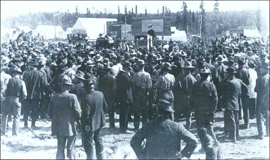
|
|
GLO auction of Anchorage townsites in July 1915 (BLM)
|
|
|
The General Land Office responded to the Alaska
Resources Committee report by gathering information on the economic
resources of Alaska. The agency also looked at the protection of the
Territory's resources, and in 1939, persuaded Congress to appropriate
funds for fire suppression in Alaska. This resulted in the creation of
the Alaskan Fire Control Service.
|
|
GLO in
Alaska |
|
The Alaskan Fire Control Service (AFCS) was a
bare-bones operation. It had a chief forester and 10 permanent staff
members. During the summer it was augmented by temporary fire guards and
later with CCC crews. The vastness of Alaska, however, restricted most
fire suppression work to areas accessible by railroad or highway.
|
|
Alaska Fire
Control
Service |
|
WORLD WAR II AND THE PUBLIC LANDS
|
|
|
The coming of war had a significant impact on the
activities of the General Land Office and the Grazing Service. Both
agencies were looking at ways they could contribute to the national
defense program. They tried to continue their conservation efforts on
the public lands, but this became increasingly difficult when America
entered into World War II.
|
|
|
The General Land Office and the Grazing Service found
themselves understaffed and underfunded. Civilian Conservation Corps
camps were closed in 1942 and the work of enrollees had to be
abandoned. For the Grazing Service, this meant a halt to range
improvements and a reorganization of their firefighting program. The GLO
replaced its CCC camps on the O&C with Public Service Camps staffed
with conscientious objectors, and the Alaskan Fire Control Service
received invaluable assistance from the Army. But still conservation of
the public lands suffered. Livestock trespasses increased on public
rangelands and timber harvesting on the O&C lands went above
allowable levels in an effort to meet wartime demands.
|
|
War's Impact |
|
As the end of the war neared, the GLO and the Grazing
Service began to look at ways to resurrect conservation efforts. The
General Land Office's postwar policy called for "continued management
under progressive conservation policies for...in no other way [could]
the domestic demands for maximum beneficial use of the land and
resources of the public domain, adequately be met." To accomplish that,
the GLO argued that new laws had to be provided. It recommended a review
of the public land laws and a congressional restatement of the nation's
public land policy. It also called for authority to lease acquired
mineral estates, a uniform trespass law, and the decentralization of
administrative and adjudication functions to regional offices.
|
|
Postwar Plans |
|
The General Land Office was particularly concerned
with Alaska. Construction of the Alaska Highway during the war had made
the Territory more accessible. Military and civilian personnel who had
gone to Alaska were expected to stay. The GLO believed its jurisdiction
over much of Alaska's land made it responsible for the orderly
development of the Territory. It asked for land classification authority
and laws better suited to Alaska's conditions.
|
|
Alaska Plans |
|
THE ALASKAN FIRE CONTROL SERVICE
by Roger R. Robinson
Former Director, Boise Interagency Fire Center
The Congress authorized the establishment of the
Alaskan Fire Control Service (AFCS) beginning July 1, 1939 in the USDI
under the aegis of the General Land Office. Its mission:
the detection and suppression of wild forest and
range fires on the Public Lands in the Territory of Alaska.
Western and interior Alaska for years had suffered
from large fires burning unchecked during its 5 to 6 month fire season;
fires started by trappers, miners, farmers and generally careless
travelers. It was not until AFCS had been in operation a year that it
was found lightning was in some years a major cause!
Fifty years ago relatively few people in the
contiguous states knew anything about Alaska and most of their "facts"
were wrong! The quirk of fate: Secretary Ickes on his honeymoon trip in
1938 visited Alaska and was confronted by Alaskans and shown the ravages
of wildfires and the ever-present threat to the cities and homes of the
pioneers. Anchorage had to build a major fire break (600 feet wide and 3
miles long) to protect itself from fires started by the government-owned
Alaska Railroad. Secretary Ickes was impressed and upon his return to
Washington pushed for the establishment of a firefighting agency in
Alaska.
The head office was set up in Anchorage under W. J.
McDonald, Chief, R. R. Robinson, Associate Chief, and C. W. Butler,
Chief Clerk. Two stenos, a mechanic, and a warehouseman rounded out the
Anchorage operation. Fairbanks District had a fire control officer, a
mechanic, a warehouseman and a steno. A very small amount of equipment and
10 temporary fire guards completed the roster. Although we were
responsible for detection and suppression of fires on some 125 million
acres, we obviously could do little except work on fires along the few
miles of road around Anchorage and Fairbanks. Our major effort was
getting to know the country and trying to find out what, where and how
the fire control job could be effectively accomplished. We also had to
begin an intensive education campaign to prevent fires.
With the start of World War II the Congress cut
appropriations for all "old line agencies"—for FY 1941 we received
$27,000! We survived only because all Civilian Conservation Corps
(CCC) activities on Alaska's public lands lands were
turned over to the AFCS in the fall of 1940. Their funds and personnel were used by us until
the CCC was terminated in 1942.
Beginning in 1940, the Alaska Defense Command was
establishing a military presence throughout Alaska. The Army realized
the importance of fire control in all military areas—not only for
its installations, munition dumps, etc., but also the real necessity to
keep the vital air lanes to Alaska free of smoke. We developed specially
trained and equipped fire crews and had aircraft assigned as needed for
transport to the back country. AFCS, young as we were, became a leader
in the use of aircraft in fire suppression.
AFCS survived the war years up to 1946, at which time
the BLM was created by combining the General Land Office and the Grazing
Service. Alaska became a separate region within the BLM and the AFCS
became the Division of Forestry.
|
|
|
DEMISE OF THE GRAZING SERVICE
|
|
|
Grazing Service officials also concerned themselves
with postwar policies. They wanted to reinstitute range studies and
range improvement projects. Their efforts to do this, however, were
hampered by congressional attacks.
|
|
|
The Grazing Service problems came from its effort to
raise grazing fees. The initial fee of 5 cents per animal unit month
(AUM) had been reasonable in the mid-1930s when poor economic
conditions prevailed, but prosperity had returned to the livestock
industry by the eve of World War II. In 1941, a Grazing Service study
showed that the 5-cent fee was considerably below that charged for
private and state lands and one-sixth that charged by the national
forests. The Grazing Service recommended tripling its existing fee.
|
|
Grazing Fee
Controversy |
|
Ranchers using grazing district lands opposed the
proposal. Resistance was particularly strong in Nevada, where ranchers
had just lost a suit before the U.S Supreme Court demanding that the
Grazing Service be restrained from interfering with their free use of
the public range. Faced with this opposition, Secretary of the Interior
Harold Ickes backed off the proposed fee increase.
|
|
Fee Increase
Abandoned |
|
The appointment of Clarence Forsling as Grazing
Service Director in 1944 resurrected the grazing fee issue. Like his
predecessor Rutledge, Forsling came from the Forest Service and viewed
the 1941 fee increase proposal as fair when compared with that of the
Forest Service. He asked the National Advisory Board Council to agree to
a 1941 fee increase but the board turned him down cold.
|
|
Fee Increase
Resurrected |
|
Forsling was not without allies in his call for a fee
increase. The House of Representatives' Appropriations Committee favored
the proposal. Appropriations for administration of the grazing districts
appeared high to many legislators and they wanted the Grazing Service to
cover most of its own expenses through the fees it collected. Senator
Pat McCarren of Nevada and other westerners in the Senate opposed such
an idea.
|
|
Grazing Fee
Debate |
|
By 1946, the Grazing Service was caught between a
House committee demanding a fee increase and western senators warning
against it. The trapped Grazing Service decided not to pursue the matter
further. The House Appropriations Committee reacted by cutting the
agency's funding to little more than $200,000, one-eighth of the Grazing
Service's requirements. Senator McCarren felt the reduction too drastic.
He wanted the Grazing Service subservient, but did not want it
destroyed. He worked to have the budget increased to half of what the
agency had requested. This appropriation forced the Grazing Service to
cut its personnel from 250 to 86 and to close 11 of its 60 district
grazing offices.
|
|
Grazing
Service
Dilemma |
|
BUREAU BEGINNINGS
|
|
|
As the Grazing Service's relations worsened with
Congress, Interior officials looked at merging it with the General Land
Office. Both agencies were responsible for grazing issues, but the
division of duties was awkward. The Grazing Service dealt primarily with
grazing policy, while the General Land Office handled settlement, land
sale, land exchange, and mineral entries in the grazing districts. The
GLO also administered grazing lands outside grazing districts, a task
the Grazing Service could better handle. Both agencies were responsible
for land classification and planning within grazing districts, and
consequently, both competed for funds to do the work. By integrating the
agencies' responsibilities, more effective management of the public
land's resources could be achieved through better utilization of skills
and experience. Yet, a departmental committee, seeing no need for
reorganization, recommended against the proposal in late 1945.
|
|
Consolidation
Idea |
|
In January 1946 Secretary of the Interior Harold
Ickes, perhaps concerned over the Grazing Service's troubles with
Congress, decided to again recommend a merger. In May, President Harry
S. Truman forwarded the proposal to Congress as part of his
Reorganization Plan No. 3 of 1946.
|
|
Reorganization
Plan No. 3 of
1946 |
|
By law, the proposed merger could only be prevented
if both houses of Congress passed nonconcurrent resolutions. The House
of Representatives did this, but the Senate, after much debate, did not.
On July 16, 1946, the Grazing Service and the General Land Office became
the Bureau of Land Management, and "with that date," notes historian E. Louise Peffer,
"there...opened 'a new chapter in the history of...[public] land
administration in the United States.'"
|
|
A New
Agency
Created |
|
FURTHER READINGS |
|
|
There are several good general public land history
overviews. Benjamin Hibbard's A History of the Public Land
Policies (1924) is quite helpful in sorting out the numerous land
laws and their requirements. The Lure of the Land: A Social History
of the Public Lands from the Articles of Confederation to the New
Deal (1970) by Everett Dick is written for general readers, as is
Roy M. Robbins', Our Landed Heritage: The Public Domain,
1776-1970 (Revised edition, 1976). The authoritative History of
Public Land Law Development (1968) written by Paul Gates is
mandatory reading for anyone truly interested in the history of public
land policy.
For books with readings on various aspects of public
land policy, see The Public Lands: Studies in the History of the
Public Domain (1962) edited by Vernon Carstensen and Paul Gates, ed.,
Public Land Policies: Management and Disposal (1979).
On the early aspects of public land policy, Malcolm
J. Rohrbough's The Land Office Business: The Settlement and
Administration of American Public Lands, 1789-1837 (1968) is outstanding. On
military land bounties, see Jerry O'Callaghan's, "The War Veteran and the
Public Lands," in The Public Lands: Studies in the History of the Public
Domain (1962), edited by Vernon Carstensen.
On the General Land Office and its operation, see
Malcolm Rohrbough's, "The General Land Office, 1812-1826: An
Administrative Study," Ph.D. dissertation, University of Wisconsin,
1963; F. H. White's, "The Administration of the General Land Office,
1812-1911," Ph.D. dissertation, Harvard University, 1912 and Milton
Conover's, The General Land Office: Its History, Activities and
Organization (1923).
Closely intertwined with public land questions has
been the federal government's policy toward Native American possession
of land. Francis Paul Prucha's two volume The Great Father: The
United States Government and the American Indians (1984) is a
comprehensive look at federal Indian policy.
The process of surveying the public lands is a
subject of interest to many. For an instruction to the subject, readers
should refer to Joseph Ernst's, With Compass and Chain (1979);
Lola Cazier's, Surveys and Surveyors of the Public Domain,
1785-1975 (ca. 1975); and C. Albert White's, A History of the
Rectangular Survey System (1982). The impact of the rectangular
survey system on the environment is well addressed by Hildegard Binder
Johnson in Order Upon the Land: The U.S. Rectangular Land Survey and
the Upper Mississippi Country (1976).
The federal government's grants of land to the states
was an important feature of public land policy. Of interest here is
Matthais Orfield's, Federal Land Grants to the States with Special Reference to
Minnesota (1915).
Grants of public lands for the construction of
railroads is a topic that has attracted the attention of numerous historians. A few
of the works available are Carter Goodrich's, Government Promotion of
American Canals and Railroads, 1800-1890 (1960); Thomas E. Root's,
Railroad Land Grants from Canals to Transcontinentals (1986);
William S. Greever's, Arid Domain: The Santa Fe Railway and Its
Western Land Grant (1954); and Ross Cotroneo's, The History of
the Northern Pacific Land Grant, 1900-1952 (1979).
Private land claims and grants have not received the
attention they deserve. Claims that are a consequence of early land
acquisitions of the United States' are discussed by Paul Gates' "Private
Land Claims in the South," in Public Land Policies: Management and
Disposal (1979) edited by Paul Gates. Mexican and Spanish grants in
New Mexico are taken up by Victor Westphall in Mercedes Reales:
Hispanic Land Grants of the Upper Rio Grande Region (1983).
The settlement laws and their operation in the later
half of the nineteenth century are discussed in numerous books and
articles. Those interested in this subject might consider starting with
"The Homestead Law in an Incongruous Land System" by Paul Gates in
The Public Lands: Studies in the History of the Public Domain
(1962) edited by Vernon Carstensen. Also good is John T. Ganoe's, "The
Desert Land Act in Operation, 1877-1891," in Public Land Policies:
Management and Disposal (1979) edited by Paul Gates. Harold Durham's
Government Handout: A Study in the Administration of the Public
Lands, 1875-1891 (1970) is indispensable to serious students of
public land policy. For homesteading after 1900, see Mary W. M.
Hargreaves', Dry Farming in the Northern Great Plains, 1900-1925
(1957); Paula M. Nelson's, After the West was Won: Homesteaders and
Town-Builders in Western South Dakota, 1900-1917 (1986); and Barbara
Allen's, Homesteading the High Desert (1987).
Few histories have been written on the administration
and disposition of the public domain within their borders. Some of those
that have been written are Paul Gates' Fifty Million Acres: Conflicts
Over Kansas Land Policy, 1854-1890 (1954); The Public Domain in
New Mexico, 1854-1891 (1965) by Victor Westphall; Stephen
Strausberg's, Federal Stewardship on the (Indiana) Frontier
(1979); and The Disposition of the Public Domain in Oregon (1979)
by Jerry O'Callaghan.
Mineral policy is discussed by Robert W. Swenson in
"Legal Aspects of Mineral Resources Exploitation" in Paul Gates'
History of Public Land Law Development (1968), and in Public
Domain—Private Dominion: A History of Public Mineral Policy in
America (1985) by Carl Mayer and George Riley. Petroleum policy is
taken up by John Ise in The United States Oil Policy (1926). On
early federal government geological investigations and the U.S.
Geological Survey, see Richard A. Bartlett's, Great Surveys of the
American West (1953); Wallace Stegner's, Beyond the Hundredth
Meridian: John Wesley Powell and the Second Opening of the West
(1954); and Mary C. Rabbitt's, Minerals, Lands, and Geology for the
Common Defense and General Welfare: A History...of the U.S.
Geological Survey, Before 1879-1939, 3 vols. (1979, 1980, 1986).
Irrigation and water in the West are addressed by
Donald Worester's, Rivers of Empire: Water, Aridity and the Growth of
the American West (1986); Donald J. Pisani's, From the Family Farm
to Agribusiness: The Irrigation Crusade in California and the West,
1850-1931 (1984); and Michael C. Robinson's, Water for the West: The
Bureau of Reclamation, 1902-1977 (1979).
On timber and forestry in general, refer to the work
of Thomas Cox, Robert Maxwell, P. D. Thomas, and Joseph Malone, in
This Well-Wooded Land: Americans and Their Forests from Colonial
Times to the Present (1985). On the development of national forest
policy, see Samuel T. Dana's, Forest and Range Policy: Its
Development in the United States (1956), and Harold Steen's, The
U.S. Forest Service: A History (1976). The O&C revested lands
are discussed in Elmo Richardson's BLM's Billion-Dollar Checkerboard:
Managing the O&C Lands (1980) and the The O&C Lands
(1981) by the University of Oregon's Bureau of Governmental Research and
Service.
The national park system is well-documented by Alfred
Runte in his National Parks: The American Experience
(1979).
Some books on conservation policy are Samuel Hays',
Conservation and the Gospel of Efficiency: The Progress Conservation
Movement, 1890-1920 (1959); Elmo Richardson's, The Politics of
Conservation: Crusades and Controversies, 1897-1913 (1962); E.
Louise Peffer's, The Closing of the Public Domain: Disposal and
Reservation Policies, 1900-50 (1951); Donald Swain's, Federal
Conservation Policy, 1921-1933 (1963); and A.L. Riesch Owen,
Conservation Under FDR (1983).
Grazing of the public domain has received much
attention from historians and other writers, particular reference should
be made to George Rollins', The Struggle of the Cattleman, Sheepman,
and Settler for Control of Lands in Wyoming, 1867-1910 (1979); E.
Louise Peffer's, The Closing of the Public Domain: Disposal and
Reservation Policies, 1900-50 (1951); William Voigt, Jr.'s,
Public Grazing Lands: Use and Misuse by Industry and Government
(1976); Philip O. Foss', Politics and Grass: The Administration of
Grazing on the Public Domain (1960). A history of the Grazing
Service is much needed but see Farrington R. Carpenter's,
Confessional of a Maverick: An Autobiography (1984), and Marvin
Klemme's reminiscence about his time with the agency in Home Rule on
the Range: Early Days of the Grazing Service (1984).
Public land policy toward Alaska has been largely
ignored by historians. For some background, see Ernest
Gruening's, State of Alaska (1958); William Hunt's, Alaska: A Bicentennial
History (1976); and Melody Webb's, The Last Frontier: A History of the
Yukon Basin of Canada (1985).
|
|
chap1.htm
Last Updated: 08-Sep-2008
|