|
LAKE ROOSEVELT The Grand Coulee Dam and the Columbia Basin Reclamation Project |
|
Section III.
THE COLUMBIA RIVER AND ITS WATERSHED
THE COLUMBIA RIVER BASIN
EXTENT OF THE COLUMBIA RIVER WATERSHED
The drainage basin of the Columbia River covers on area of 259,000 square miles. It includes almost all of Idaho, the greater parts of Washington and Oregon, and parts of British Columbia, Montana, Wyoming, Utah, and Nevada, an area equal to practically four times that of the New England States.
The Columbia Basin Project is concerned with the 74,100-square mile area above the Grand Coulee, drained by the Columbia and its upper tributaries. Of this area, 39,000 square miles are in Canada.
|
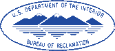
| Kettle Falls, 112 miles above the dam, marks a spot of scenic and historic interest in the reservoir area which is generally surrounded by low timber-covered mountains. The 30-foot falls will be submerged |
THE COLUMBIA RIVER
The Columbia River, second in flow only to the Mississippi and greatest in potential power among the rivers of North America, rises in Columbia Lake at an elevation of 2,650 feet in the southeastern part of British Columbia, flows northwesterly 195 miles, between the high timber-covered Rocky and Selkirk Mountains, thence southward 270 miles, entering the State of Washington 151 miles, by river, above the mouth of the Grand Coulee and the site of the dam. It contributes about 37 percent of the flow at the dam.
THE KOOTENAI RIVER
Among its principal tributaries above the dam are the Kootenai, Clark Fork, and Spokane Rivers. The Kootenai has its source about 76 miles north of that of the Columbia, but flows in an opposite direction 180 miles into Montana, thence into Idaho; and, after making a 167-mile loop in the United States, returns into British Columbia through Kootenai Lake, and joins the Columbia 30 miles north of the international border.
The Kootenai River drains an area of 19,450 square miles, 14,550 square miles of which are in Canada. Its average annual flow is about 34,000 second-feet, and its average run-off 25,300,000 acre-feet, about 31 percent of the run-off above the dam.
|
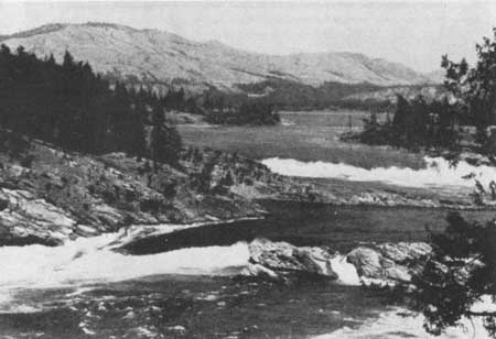
| Below the dam site, the river is bounded by rugged, arid hills extending back on the right bank to the Okanogan and Cascade Mountains, and on the left to the Columbia Lava Plateau |
THE CLARK FORK RIVER
Clark Fork of the Columbia River rises on the west side of the Rocky Mountains near Butte, Mont., and not far from the headwaters of the Missouri River, and the Snake River, largest tributary of the Columbia. Its course is generally to the northwest through Montana about 360 miles into Pend Oreille Lake in the panhandle section of Idaho. Thence its course is northerly nearly 100 miles, through Idaho and northeastern Washington into Canada, where it empties into the Columbia about one-half mile above the international boundary. The Clark Fork basin covers 25,820 square miles, only about 1,200 of which are in Canada. Its average annual flow is about 25,000 second-feet, and its average annual run-off 19,300,000 acre-feet. It brings into the Columbia about 23 percent of the water passing the dam.
THE SPOKANE RIVER
The Spokane River is, relatively, a minor tributary, its drainage area being only about 6,600 square miles, and its average annual flow only about 8,000 second-feet. Its source is Coeur d'Alene Lake in Idaho, which receives its water supply chiefly from the Coeur d'Alene and St. Joe Rivers, rising on the western slopes of the Bitter Root Mountains. The lake is a valuable regulator of the flow of the Spokane River. The average annual run-off of the Spokane River drainage basin is about 5,800,000 acre-feet.
|
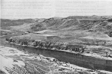
| Blockaded by ice, this canyon was for thousands of years filled to overflowing with turbid glacial water |
COLUMBIA RIVER ABOVE GRAND COULEE
At the dam site the Columbia flows in a channel 700 to 850 feet wide, in a canyon 2,000 feet wide at the bottom and a mile wide at the top. The average elevation of bedrock is about 875, of the river bed about 910, and of the low stage water level about 933. The average high-water mark over a period of years was 978, but in the flood of 1894 it is believed to have reached elevation 1,003.
The drainage basin above this point covers 74,100 square miles, 39,000 of which lie in British Columbia. Particularly in Canada the headwaters of the Columbia rise in high mountain snows, glaciers, and lakes, which have the effect of regulating the river flow and bringing high-water periods in the months of June and July which will be highly advantageous to both irrigation and power development an the Columbia Basin Project.
|
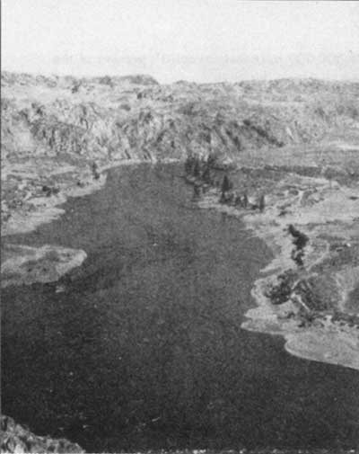
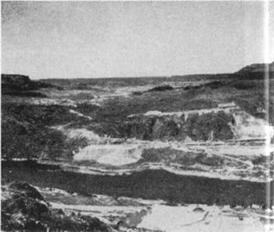
| Entrance to the Grand Coulee, prehistoric diversion channel, cut by a torrential glacial Columbia in the last Ice Age |
The mean flow of the river at the dam site during the past 23 years was 110,000 second-feet. A minimum of 17,000 second-feet and a maximum of 492,000 second-feet have been recorded, and it is estimated that in the flood of 1894 a flow of 725,000 second-feet was reached. By means of the Grand Coulee Dam it will be possible to regulate the flow to a minimum of 35,000 second-feet
The average annual run-off of the Columbia Basin above the Grand Coulee Dam is 80 million acre-feet. At an estimated maximum annual requirement of 5 feet of water for each acre of land to be irrigated, only 6 million acre-feet will be diverted from the river. The run-off at the Grand Coulee Dam is five times as great as that of the Colorado River at Boulder Dam.
| <<< Previous | <<< Contents>>> | Next >>> |
grand_coulee_dam/sec3a.htm
Last Updated: 01-Feb-2008