|
CABRILLO
Historic Structures Report |

|
ARCHITECTURAL DATA
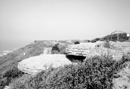
The following section summarizes information on each of the nineteen structures dealt with in this report, including their location, a brief history, physical description, current condition and a structural analysis. Information on structures of similar type, such as the two end stations Calef & Wilkeson, is grouped.
The structures are concentrated primarily in two locations. Structures on the east side of Point Loma overlooking San Diego Bay are accessed via the Bayside Trail and those located on the west side facing the Pacific Ocean are accessed by roads.
The subject structures are primarily reinforced concrete construction, with concrete floors, walls and roofs. Most of the structures are partially buried beneath the ground or bermed into the hillside. Variations from this typical description include the wood-framed roof of the army radio station, the steel-framed roofs of the searchlight shelters, the primarily corrugated steel pipe bunker complex structures, and the circular concrete gun emplacements, almost fully buried in the ground.
STRUCTURAL SUMMARY
Based upon visual observations (structural drawings are not available), the existing structures typically appear adequately sized and constructed to resist the expected vertical (gravity) and lateral (wind and earthquake) loads. Because they were designed for military purposes, they would likely have been intended to withstand substantial forces. Hence the concrete walls and roofs appear to have been provided with generous thicknesses and reinforcing.
Some deterioration has occurred in the reinforced concrete walls and roofs. This consists primarily of cracking in the concrete walls and localized spalling of the concrete, with the reinforcing bars exposed and corroded in some locations. In addition, the steel components of the structures are corroded in many areas. This deterioration is consistent with the age and weather to which these structures are exposed. In most cases the deterioration is not advanced enough to significantly compromise the integrity or capacity of the structures, however if left unchecked it will eventually become a problem. Specific locations where this deterioration is more significant are noted in the evaluations.
|
| Figure 3. Cabrillo National Monument historic harbor defense structure locations. (click on image for an enlargement in a new window) |
|
| Figure 4. The Army Radio Station front facade. |
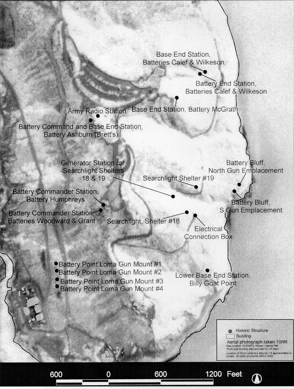
ARMY RADIO STATION (Rehabilitation)
Location
The Army Radio Station sits 1000 feet northwest of the old lighthouse, its radio towers were once situated between the two structures.
History
World War I stimulated San Diego coastal defense developments, including the construction of the Army Radio Station at Fort Rosecrans, authorized in 1917. Both constructed and operational in 1918, the building was the Army's first radio station in the Harbor Defenses of San Diego. The structure functioned as a radio station through 1936, when radio operations were relocated to the harbor defense command post. The building next became the meteorological station for the coast artillery, later housing the Monument Superintendent's office, then storage. The building was rehabilitated in 1998-1999. An exhibit on the military history of Fort Rosecrans was installed in March, 1999.
Description
Exterior
This one-story building is rectangular in plan and set into the sloping hill (figures 4 and 5). Walls are reinforced concrete, with a flat, asphalt roll roofing-clad, wood-framed roof. One single, wood-panel door with glazing, is located on the northwest side of the building. Windows are fixed, wood sash with eight lights each containing wire-mesh glazing, replicated from a sample window taken from Battery Whistler. The original door hardware was replaced, originally consisting of a knob and keyhole system.
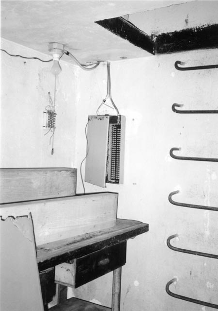
Interior
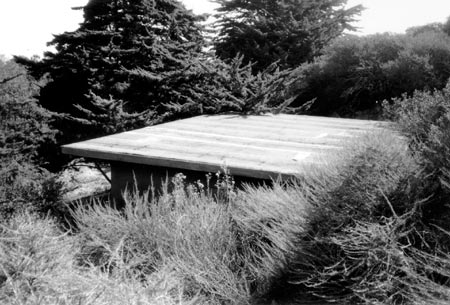
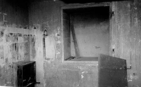
The three rectangular interior rooms feature vinyl tile flooring, painted concrete walls, one-and-one-half- inch crown molding and a beaded six-inch wood tongue-and-groove ceiling. Flat wood door and window surrounds are approximately five-inches wide. The Operating Room contains two fluorescent light fixtures, while the Sleeping Quarters and Motor Generator rooms each have one. Electrical equipment hangs on the south wall of the Operating Room. The opening connecting the Operating Room and the Motor Generator Room is an alteration, as is the tan and green vinyl flooring and fluorescent lighting (figure 6).
Condition
Exterior
The exterior is in good condition overall. However, the concrete foundations and walls are in fair condition with spalls, exposed reinforcing rod, and cracks visible on the exposed north facade. At the time of this survey, the south foundation was partially covered by the hillside and excavation to clear a path around the building was in progress. The wood trim at the roof fascia needs paint, while the roof itself was recently replaced. Nails attaching the non-original plywood infill have punctured the door and the surrounding trim. The windows are in good condition.
Interior
The concrete walls are in fair condition with hydrostatic pressure at the lower south wall causing blistering of the paint and concrete and stress cracks at the window and door headers. Unfinished concrete and spalls are visible at the new door cut. The ceiling has loose boards, failing paint and missing crown molding trim. The ferrous metal suspended light fixtures are corroded.
Structural Analysis
No significant structural concerns were noted. The cracks and spalling in the concrete walls and foundations noted above are relatively minor and do not at this time appear to compromise the structural capacity of the building.
|
| Figure 5. Roll-roofing clads the roof of the Army Radio Station. |
|
| Figure 6. A non-original opening connects the Operating and Motor Generator Rooms. |
|
| Figure 7. The small electrical box is located on the Bayside Trail. |
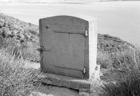
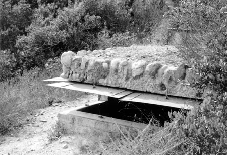
ELECTRICAL CONNECTION BOX (Restoration)
Location
The Electrical Connection Box stands on the Bayside Trail, near Searchlight Shelter No. 18 and the Generator Station for Searchlight No. 18 and No. 19.
History
The concrete electrical connection box was installed during WWII as part of the defense modernization activity. The box was part of the artillery fire control system. Two dates appear on the box, "1941, U.S.A." on the exterior and "1909 Engineers Department U.S. Army, Colin Electric Company, New York" on an aluminum box within the metal door. The electrical connection box remains locked.
Description
Exterior
This reinforced concrete, two-foot-by-three-foot-by-four-foot high electrical connection box is rectangular in plan with tapered concrete sides capped by a continuous concrete arched top (figure 7). Painted drab green, the box sits on a six-inch concrete slab foundation. One painted, one-eighth-inch steel plate metal door with angle iron reinforcing, rivets, and a single latch is attached to the southwest face.
Interior
The interior of the electrical connection box is concrete, except for the one-eighth-inch steel plate door. According to drawings, the box contains a ten-pin controller receptacle, a power terminal box and a junction box. Four, two-inch galvanized iron conduits disappear below ground through the concrete slab base.
Condition
Exterior
Deterioration includes: spalling concrete and exposed reinforcing metal at the north side; a concrete spall at the east face; spalling at the foundation; soil erosion exposing the foundation; metal corrosion at the top left corner of the door; and corroding metal hinges and cross bars.
Interior
The box was locked and could not be opened with the key provided to the survey team.
Structural Analysis
No significant structural concerns were noted. The spalling noted above in the exterior concrete surfaces is relatively minor and does not at this time appear to compromise the structural capacity of the box. The soil erosion at the base of the box appears to be a consequence of the location of the box, on a slope and at the side of a road/path where rainwater run-off will accumulate. The erosion does not appear to compromise the capacity of the foundation at this time.
|
| Figure 8. An overall view of Searchlight Shelter No. 15's structure visible above ground. |
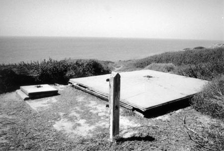
SEARCHLIGHT SHELTER NO. 15 (Preservation)
Location
This searchlight is located on the west side of Point Loma. The nearby generator that originally supplied power to it is no longer visible or accessible.
History
Constructed during WWII, this structure sheltered a 60-inch coastal searchlight previously mounted on a counterweighted elevator. The structure is similar to other structures at the monument dating c.1916-1921. The searchlight (now missing) and its operating mechanism were salvaged from the defunct, c. 1921 Searchlight No. 4. To prevent vandalism, the metal roof of the shelter was sealed, and the structure remains closed to the public.
Description
Exterior
This is a reinforced concrete, rectangular plan, multi-level underground searchlight shelter. The mechanized, hipped, riveted metal roof (figure 8), painted green, rests on a wooden curb. Metal rails mounted on concrete extend to the north, originally allowing the retracting roof to slide open, exposing the counterweighted searchlight platform and its searchlight. The interior of the shelter is accessed through a riveted metal hatch, also painted green, located in the southwest corner. An above-ground, concrete post formerly supporting a telephone box stands at the southeast corner of the shelter. The roof operating mechanism is located at grade at the northeast corner.
Interior
This multi-level rectangular space features concrete flooring and walls with visible formwork lines. The ceiling is the exposed underside of the steel roof. The shelter is accessed through a manhole at grade located in the southwest corner. Steel rungs embedded into the concrete wall serve as a ladder leading into the personnel portion of the shelter. Nine-feet-six-inches deep, the operator area contains a cable pit that provided electrical service from the nearby generator. The 15-foot, two-inch deep lower space, containing the counterweighted elevator, is accessed by a metal ladder. The elevator is operated manually with a chain sprocket drive (figure 9).
Condition
Exterior
The metal roof vent is missing from the roof of this structure, as is the original square metal entry hatch which was replaced with the current sheet metal one at some point. The roof exhibits heavy overall corrosion with concentrations at the edges. Corrosion appears at all riveted connections and at the metal half-round trim piece that is also bent. Heavy corrosion damage is present on the north and east sides of the roof. Originally retractable, the roof has been sealed closed. The wood curbs supporting the roof are deteriorated, especially to the south where the curb has split horizontally into two pieces. The concrete at the entry hatch exhibits cracks. Spalls are present along the beveled concrete edge that supports the roof assembly, especially on the west side. Reinforcing rod corrosion stains are visible on all concrete surfaces.
Interior
All steel elements exhibit corrosion. The base of the elevator framework is severely corroded. The concrete is generally in sound condition, although efflorescence is visible at the ceiling near the elevator gear traces and rust stains run down the west wall below the entry hatch. Graffiti on the south wall includes some appearing to date from 1946.
Structural Analysis
Similar to Searchlight No. 19, the concrete surfaces exhibit some spalling and cracking, which is relatively minor and does not at this time appear to compromise the structure's capacity. The concrete deterioration at this searchlight appears slightly worse than at Searchlight No. 19. The spalling at the concrete post appears to be the result of inadequate concrete cover to the reinforcing during the original construction.
Also similar to Searchlight No. 19, the steel elevator platform and frame for the searchlight, and the steel roof cover, are corroded. For the most part, this appears to be primarily superficial and is unlikely to have compromised the structural capacity of the main steel members. However the capacity of the bolts and brackets connecting the members together may have been reduced significantly.

|
| Figure 9. Interior view of the elevator platform operating mechanism. |
|
| Figure 10. Originally 75-feet of narrow-gauge rail extended out, but only five feet remain today. |
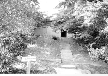
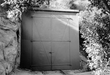
SEARCHLIGHT SHELTER NO. 18 (Restoration)
Location
This structure is located on the Bayside Trail, near Searchlight Shelter No. 19 and the Generator Station for Searchlight No. 18 and No. 19.
History
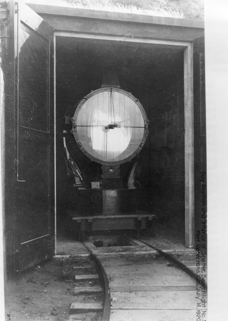
Constructed in 1918-1919, this World War I structure sheltered a 60-inch searchlight mounted on narrow-gauge rails. The approximately 75 feet of rails extended from the structure up the Bayside Trail, allowing the searchlight movement to a point overlooking the harbor entry. Originally named Searchlight No. 5, the searchlight shelter was renamed No. 11 in 1936 when additional searchlights were added to the coastal defense system. The searchlight was renamed No. 18 during WWII. This structure currently contains a searchlight, which is not the original. The searchlight is not mounted on the tracks inside the shelter. The shelter remains closed to the public.
Description
Exterior
This single-story reinforced concrete structure is rectangular in plan. Its flat, vegetation-camouflaged roof features a drip edge at the front, and a twelve inch diameter clay ventilation pipe penetrating the roof toward the rear of the structure. Thirteen foot high double access doors are wood-framed, clad in metal, and painted drab green (figure 10). The remains of the narrow gauge rails protrude from underneath these doors, terminating approximately five feet in front of the structure.
Interior
The single, rectangular room features a concrete slab floor, and concrete walls and ceiling with visible formwork lines. A cable pit near the doors provided electrical service from the nearby generator station. Removable two-by-four wood boards cover the cable pit, currently filled with water. Iron narrow-gauge rails, visible from the exterior, are embedded in the concrete floor, stopping halfway into the interior (figure 11).
Condition
Exterior and interior
The building is in good condition. Deterioration includes erosion of the surrounding hillside, minor corrosion at the doors, and damage to the clay vent pipe.
Structural Analysis
No significant structural concerns were noted. The concrete is in good condition with only very minor cracking.
|
| Figure 11. The 60-inch Searchlight originally housed in Searchlight Shelter No. 5 (later numbered 18). |
|
| Figure 12. Only the metal roofs and a concrete post are visible above ground. |
SEARCHLIGHT SHELTER NO. 19 (Preservation)
Location
This structure is situated on a bluff above the Bayside Trail, near Searchlight Shelter No. 18 and the Generator Station.
History
Constructed in 1918-1919, this World War I structure sheltered a 60-inch searchlight mounted on a counterweighted elevator. Originally named Searchlight No. 6, the searchlight shelter was renamed No. 12 in 1936 when additional searchlights were added to the coastal defense system. The searchlight was renamed No. 19 during WWII. This structure no longer contains a searchlight. The shelter remains closed to the public.
Description
Exterior
This reinforced concrete, multi-level underground structure features a square, mechanized roof that moves north on metal tracks embedded in concrete curbs. The riveted, metal hipped roof, painted green, rests on a wooden structure (figure 12). The roof slides north to completely expose the main room of the structure and the counter-weighted elevator platform below. A single, solid, riveted metal hatch, located at the south end provides access to the structure. A cog and chain roof opening mechanism is located at grade, west of the roof. An above-ground, single concrete post situated also to the west of the roof, originally supported a communications control box.
Interior
The interior is bi-level. The southern third of the space comprises the operator area, while the remainder drops down to house the searchlight lift. The space features concrete slab floors and walls with visible formwork lines. The exposed underside of the steel roof cover forms the ceiling (figure 13). The shelter is accessed through a manhole at grade. Steel rungs embedded into the concrete wall serve as a ladder leading into the upper, personnel portion of the shelter. Nine-feet, six-inches deep, this space contains a cable pit that provided electrical service from the nearby generator station, and a wood tongue-and-groove closet located in the southeast corner. The closet features a five-panel wood door and shelving. The 14-foot deep lower space containing the counterweighted elevator is accessed from the personnel area by a metal ladder. The elevator is operated manually with a chain sprocket drive. Traces of gray-green paint remain on the walls.
Condition
Exterior
Deterioration includes minor cracking at the concrete walls; rotting wood at the roof base; corrosion at the metal roof and platform mechanism; and cracking, spalling and exposed reinforcing rod at the concrete post. The metal cover is sound with some corrosion evident at the edge, although it is no longer firmly attached. Invasive vegetation covers part of the structure and the roof tracks.
Interior
The concrete walls exhibit minor deterioration including spalling concrete over the control area.
Structural Analysis
As noted above, the concrete surfaces have some spalling and cracking, which is relatively minor and does not at this time appear to compromise the structure's capacity. The spalling and exposed reinforcing rod at the concrete post appears to be the result of inadequate concrete cover to the reinforcing during the original construction.
As noted above, the steel elevator platform and frame for the searchlight, and the steel roof cover, are corroded. For the most part, this appears to be primarily superficial and is unlikely to have compromised the structural capacity of the main steel members. However the capacity of the bolts and brackets connecting the members together may have been reduced significantly.

|
| Figure 13. The underside of the elevator platform viewed from the pit. |
|
| Figure 14. Nestled in the hill, this generator station served Searchlights No. 18 and No. 19. |
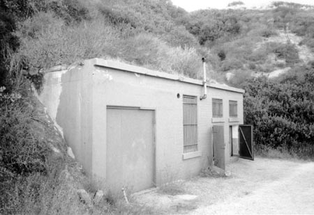
GENERATOR STATION FOR SEARCHLIGHT NO. 18 & NO. 19 (Restoration)
Location
This structure is situated in a ravine along the Bayside Trail and supplied power to Searchlight No. 18 and No. 19.
History
Constructed in 1918-1919 to serve Searchlights No. 5 and No. 6 (later renamed No. 18 and No. 19), this World War I structure is one of three known stations of its type. When operational, the structure contained two Fairbanks-Morse gasoline-powered 25kw generators. These generators featured four cylinder engines, 560 RPM, 43/54 horsepower and delivered direct current power to the searchlights. Two underground gasoline tanks located in front of the station were removed in 1985. The station remains closed to the public.
Description
Exterior
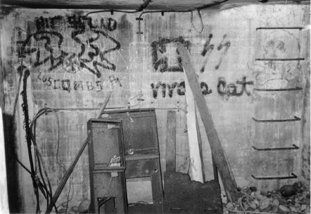
This single-story flat-roofed reinforced concrete structure is rectangular in plan. The primary facade features two riveted metal doors with windows above, one large window and a plywood-infilled doorway (figure 14). The three windows feature projecting concrete sills and vertical steel security bars. One exhaust vent protrudes from this wall and the hole remains from another, although the vent is gone. Two vents also penetrate the roof. Alterations include the widening of the larger door, originally a single wood door leading into the engine room; and the infill of a second large window (figure 15). The two smaller windows located above the metals doors, originally glazed, are covered with chicken wire. The remaining larger window, also originally glazed, is now sealed with plywood.
Interior
The two rectangular interior rooms feature concrete slab flooring, and reinforced walls and ceilings. A four-inch wide flat wood surround, partially missing, trims the opening connecting the radiator and the engine rooms. Alterations to the engine room include removal of the generating sets and the widening of the exterior doorway, requiring infill of an original window opening.
Condition
Exterior
Concrete is in good condition with select spalling occurring at the drip edge and at ferrous metal attachments (hinges and vents). Paint has peeled away, especially where vegetation once covered the side facade.
Interior
Corroded reinforcing rod has caused concrete spalling at the metal door header. Numerous impact spalls speckle the walls and ceiling.
Structural Analysis
No significant structural concerns were noted. The minor cracking and spalling in the concrete walls do not at this time compromise the structural capacity of the building. The corroded reinforcing rod at the pockets above the door headers appears to have been left exposed during the original construction. The spalls on the interior walls appear to be the result of impact rather than concrete deterioration.
|
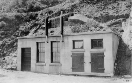
| Figure 15. The generator station prior to alteration. |
|
| Figure 16. The missing metal observation slot shutters are located inside this structure. |
BASE-END STATION, BATTERY MCGRATH (Preservation)
Location
This structure is located just below the Cabrillo statue, on the east side of Point Loma.
History
This structure served as the sole fire control point for Battery McGrath, the only Endicott battery incorporated into the updated harbor defenses. Constructed c.1920, this station was part of a remote network that tracked targets and relayed the data to their associated guns via a plotting room. Observers in these stations used sophisticated data collection instruments that improved the coastal gun aiming system. Originally temporary structures, by WWI concrete walls and tar and gravel roofs provided permanence. During WWII the tar and gravel roofs were replaced with earth-covered rough aggregate concrete roofs. Cemented boulders on the roof provided additional camouflage. The station was abandoned in 1942.
Description
Exterior
The base-end station for Battery McGrath is identical to the base-end station and battery commander station for batteries Calef and Wilkeson, except that the structure has a steeper roof slope (figure 16). The structure was also painted a drab yellow at one time.
Interior
The interior is identical to that of the base-end station and battery commander station for batteries Calef and Wilkeson, except that it has a small storage compartment built into the rear wall (figure 17). The steel plate door for this compartment is missing, although the hardware remains. Olive drab paint once covered the interior concrete. A speaking tube running to the nearby 'old restrooms' remains in place, although the restrooms are now in ruins.
Condition
Exterior
The concrete is in good condition with some cracks and exposed reinforcing bar. The steel surface hatch is extremely corroded with holes and missing parts. The asphalt waterproofing is worn and stones have dislodged, leaving voids. Exposed reinforcing rod and spalls mar the main observation slot. Covered with temporary wooden slats, its removed metal shutter is stored inside. At the south observation slot, the header is cracked and the metal shutters corroded. Vegetation has rendered the hatch inoperable.
Interior
The interior walls feature several concrete spalls: spalls caused by rusted ferrous metal near the concrete surface; minor spalls at metal attachments; and a severe spall at the southeast corner opening. These walls were originally painted, but only fragments of the paint remain. Graffiti and corrosion stains from metal attachments are present on the walls. Ghosts of items no longer present on the south wall are apparent.
Structural Analysis
The spalled concrete and exposed reinforcing rod at the front and side areas of the roof appears to be a consequence of casting the large stones into the face for camouflage. The deterioration at the front and sides of the roof appears primarily as a result of shrinkage over time of the concrete surrounding the large stones. This shrinkage would have caused cracks around the stones, which would have then allowed water, salts and air to penetrate down to the rebar. The reinforcing rod would have then begun to corrode, and the resulting expansive forces would then have spalled the stones. The only structural concern is that this deterioration reduces the capacity of the anchors that support the steel shutters. The cracks at the interior concrete surfaces are relatively minor and do not at this time appear to compromise the structure's capacity.
|
| Figure 17. Unique to McGrath's base-end station, a storage compartment is present on the rear wall. |
|
| Figure 18. Metal shutters in the open position allow visual access through observation slots. |
BASE-END STATION, BATTERIES CALEF & WILKESON (Preservation)
BATTERY COMMANDER STATION, BATTERIES CALEF & WILKESON (Preservation)
Location
These structures are located on a bluff above the Bayside Trail. The base-end station is the lower of the two structures, while the battery commander's station is the higher.
History
These structures were among the first base-end stations built at Fort Rosecrans. Base-end stations were part of a remote network that tracked targets and relayed data to their associated guns via a plotting room. Recommended in 1914, they first appear on a 1915 map of the fort's defenses. The original temporary structures were replaced c.1920 with concrete walls and tar and gravel roofs. During World War II the tar and gravel roofs were replaced with earth-covered rough aggregate concrete roofs. Cemented boulders on the roofs provided additional camouflage. The stations were abandoned in 1942.
Description
Exterior
These one story, eight foot square reinforced concrete structures sit partially into the hillside (figure 18). The rough concrete roofs are camouflaged with earth and edged with eight inch diameter stones embedded into the concrete. On each structure, four metal awning shutters cover observation slots which pierce the smooth concrete walls on three sides. Square roof hatches with metal covers resting on concrete curbs access the structures. Lush vegetation conceals these structures from view.
Interior
The single, square rooms each feature a concrete slab floor, and reinforced concrete walls and ceilings with visible formwork lines. Steel rung ladders, embedded into the concrete walls, lead from the roof hatches into the spaces below. These spaces contain corner cable pits; low, concrete, octagonal DPF (depression position finder) bases with surmounting wood swivel benches; and miscellaneous conduit attachments (figure 19). The survival of the wood swivel benches is rare. The base-end station features a vertical electrical raceway at the south end of the west wall, and a horizontal chase in the south and east walls. The battery commander's station has a metal raceway at the east and south walls connecting to an electrical box in the southwest corner. Military graffiti remaining on the base-end station walls presumably marked orientation data for the operators.
Condition: Base-End Station
Exterior
Curing cracks from the initial construction and corrosion jacking mar the camouflage roof. Weather and exposure has widened these cracks, causing additional damage. Concrete spalling is typical at the concrete headers. Metal corrosion covers the top hatch hardware, especially the bolts and edges. The concrete hatch curb is badly spalled. The metal shutters have surface corrosion and all hardware is deteriorated. Vegetation covers the roof drainage channels.
Interior
Concrete walls and ceilings are solid. Water seepage has contributed to failing paint and small attachment spalls at the south wall. The wooden bench and concrete DPF base are in good condition.
Condition: Battery Commander Station
Exterior
The large aggregate concrete walls are cracked and spalled. The camouflaged roof edges have missing stones, which have resulted in corroding exposed rebar. The top hatch, overgrown with vegetation, features minor metal corrosion and a seriously spalled and cracked concrete curb. The observation slot sills and headers are in good condition, but the metal shutters have spot corrosion. The south shutter is severely corroded at the east end. Light lichen growth covers some of the roof.
Interior
The interior features numerous concrete spalls: spalls caused by rusted ferrous metal near the concrete surface; eight minor spalls at metal attachments at the south wall; and ceiling spalls where conduit is attached. The ladder rungs at the west wall are corroded and are staining the adjacent wall. Hairline cracks and efflorescence occur at the north concrete wall. The wooden bench and concrete DPF base are in good condition.
Structural Analysis
As noted above, the concrete surfaces have significant cracking and spalling, particularly at the front and side areas of the roof, where the large stones were cast into the concrete. The square reinforcing rod is exposed in several places. This deterioration does not appear to compromise the capacity of the structure at this time, however it does reduce the capacity of the anchors which support the steel shutters. The deterioration at the front and sides of the roof appears primarily as a result of shrinkage over time of the concrete surrounding the large stones. This shrinkage would have caused cracks around the stones, which would have then allowed water, salts and air to penetrate down to the rebar. The reinforcing rod would have then begun to corrode, and the resulting expansive forces would then have spalled the stones. As noted above, the cracking at the hatch curb at the battery commander station is reasonably advanced. Other than supporting the hatch, this curb does not have a significant structural function. The remaining cracks and spalling at the interior concrete surfaces are relatively minor and do not at this time appear to compromise the structure's capacity.

|
| Figure 19. Embedded metal ladder rungs provide access from the hatch opening above. |

|
| Figure 20. These structures are accessed through hatchways or observation slots. |
LOWER BASE-END STATION AT BILLY GOAT POINT (Battery White Base-End Station) (Preservation)
Location
This structure is located on the east side of Point Loma overlooking San Diego Bay. Situated below the Bayside Trail, it is the lower of a pair, with the upper structure located on Navy property.
History
The lower of two stations at Billy Goat Point, this structure was first associated with Batteries Whistler and White. Constructed between 1916-1921, this station was part of a remote network which tracked targets and relayed the data to their associated guns via a plotting room. Observers in these stations used sophisticated instruments to collect data which improved the system of aiming for the coastal guns. Originally temporary-type structures, by WWI concrete walls and tar and gravel roofs provided permanence. During WWII the tar and gravel roofs were replaced with earth covered rough aggregate concrete roofs. Cemented boulders on the roof provided additional camouflage. This station was modified in 1925, 1928 and 1934. The station was unassigned after October 1942, when Batteries Whistler and White were decommissioned. The San Diego Urban Corps stabilized the structure in 1993. Accessed from the Bayside Trail, the station remains closed to the public.
Description
Exterior
This structure is virtually identical to the base-end station and battery commander station for batteries Calef and Wilkeson, and the base-end station for Battery McGrath (figure 20). The roof edge boulders embedded in concrete, the steel window shutters and the access hatch have all been painted.
Interior
The interior is similar to that of the base-end station and battery commander station for batteries Calef and Wilkeson and to the base-end station for Battery McGrath. The interior features a vertical raceway on the west wall descending into a corner cable pit; raceways along the bottom of the south and east walls; a low, concrete, octagonal base for a depression position finder; miscellaneous conduit attachments and an octagonal concrete azimuth instrument stand (figure 21).
Condition
Exterior
The concrete walls are cracked and spalled, particularly near the entry hatch and at the southeast corner. Exposed, rusting reinforcing steel has created corrosion jacking at this corner, where the structure is literally crumbling and in critical condition. Square reinforcing rod and the power cable wrapping (copper and lead treated with gutta percha) are visible at this corner. The camouflaged roof edges have missing stones, causing corrosion of exposed steel reinforcing bars. The support for the front shutter collapsed, and the shutter, although no longer in place, remains on site. Excessive vegetation covers the roof.
Interior
Due to the remote location, this structure has suffered from illegal entry and vandalism. The concrete interior walls are covered with graffiti and corrosion stains. Electrical, metal and wooden features are either vandalized or missing from their original locations. Evidence suggests that missing wood interior components were used as firewood. The cable pit in the southwest corner was used as a fire pit. Two broken metal observation slot shutters were found inside on the floor. The walls feature several concrete spalls: spalls caused by rusted ferrous metal near the concrete surface; minor spalls at metal attachments; and severe spalling at the southeast corner opening. Minor hairline cracks are present in both the southeast and northwest corners.
Structural Analysis
Similar to the base-end station and battery commander station for batteries Calef and Wilkeson, and the base-end station for Battery McGrath, the spalled concrete and exposed reinforcing rod at the front and side areas of the roof appear to be a consequence of casting the large stones into the face for camouflage. This spalling affects the anchors which support the steel shutters (several of these connections have already failed and the shutters are missing). The cracks and spalls at the interior concrete surfaces are relatively minor and do not at this time appear to compromise the structure's capacity.
|
| Figure 21. Electrical box debris and graffiti are the results of inactivity and vandalism. |
|
| Figure 22. Battery commander station and base-end station, Battery Humphreys. Rough-textured concrete roofs provide camouflage for these structures. |
BATTERY COMMANDER STATION AND BASE-END STATION, BATTERY HUMPHREYS (Restoration)
BASE-END STATIONS, BATTERIES WOODWARD & GRANT (Restoration)
Location
Both structures are located on the west side of Point Loma, directly below the whale overlook. The upper structure is the Battery Commander Station and Base-End Station, Battery Humphreys. The lower structure is the Base-End Stations, Batteries Woodward and Grant.
History
This pair of structures was constructed c.1936-1941, for use during World War II. The upper level of the upper structure served as the battery commander's station for Battery Humphreys, which had two six-inch guns, while the lower level served as the base-end station. The upper level of the lower structure served as the base-end station for Battery Woodward, which was located at the north end of Fort Rosecrans, and the lower level served as the base-end station for Battery Grant at Fort Emory. The structures are currently vacant and are not open to the public.
Description
Exterior
These multi-level, partially underground structures are configured roughly by their two mounded semi-circular concrete roofs (figure 22). Rough aggregate concrete with embedded steel rings cover the roofs. The steel rings were used to anchor camouflage covering. Square ferrous metal roof hatches access the interiors. The concrete walls at both levels feature observation slots facing the Pacific, protected by eight solid metal, green-painted, rectangular shutters. Hardware allows the shutters to be fixed open or closed. Miscellaneous PVC pipes are visible, formerly supplying either water or electricity.
Interior
These two-story structures each contain three rooms, one at the upper level and two at the lower. All three rooms are rectangular in plan with concrete floors, walls and ceilings. Access to the structures is through roof-mounted manholes, down steel rungs embedded into the upper-rooms' northern walls. The lower level rooms are accessed from the upper again via manhole and wall-embedded steel rungs. The upper level rooms feature one-inch galvanized pipe railing, plywood shelving, miscellaneous conduit, a telephone box and the remains of a concrete azimuth instrument stand. The rear lower room contains a cable pit in the northeast corner, a metal azimuth instrument stand on the ground, miscellaneous conduit and a fuse box. The forward lower level room was the base-end station used for observation, located two steps up. The room contains an octagonal concrete depression position finder base, a metal azimuth instrument stand and miscellaneous conduit (figure 23).
Condition
Battery Commander Station and Base-End Station, Battery Humphreys
Exterior
Concrete wall deterioration includes minor erosion, spalls, cracks and exposed reinforcing rod ends. Minor cracks and spalls are present at the east end of the structure and a portion of the lower-level roof is missing. A rust hole and overall minor corrosion mars the entry hatch. Corrosion is also present on the shutter hinges.
Interior
Conditions in the upper level room include: a hairline crack along the south wall; missing wall attachments at the north and south walls; peeling paint at the ceiling; a raised, rough spot on the floor where the azimuth instrument stand was removed; debris; and spalling around the three-inch pipe on the east elevation. The azimuth instrument stand, missing from the lower level front room, lays on its side in the lower level rear room. Overall the interior is in good condition.
Base-End Stations, Batteries Woodward and Grant
Exterior
Concrete deterioration includes minor spalls and exposed rebar, especially on the upper portion of the west wall. Some stones are missing from the roof camouflage and others have separated from the roof concrete creating gaps. The access hatch has several rust holes and overall corrosion. One of the hatch cover hinges is severed. Vegetation is encroaching from the rear of the structure.
Interior
The upper level room contains debris, graffiti on the concrete wall surfaces, and minor corrosion on the metal shutters. The lower level front room exhibits minor efflorescence, especially at the wall base, and minor spalling at ferrous metal wall attachments. Corrosion is present on the metal ladder rungs in the lower level rear room, but the rungs are still sound.
Structural Analysis
No significant structural concerns were noted. The cracks and spalling in the concrete walls and roof noted above are relatively minor and do not at this time appear to compromise the structure's capacity.

|
| Figure 23. A depression position finder with extant swivel bench, typical to both structures. |
|
| Figure 24. Rough-textured concrete provides camouflage for this structure. |
BATTERY COMMANDER AND BASE-END STATION, BATTERY ASHBURN (Restoration)
Location
This battery commander station and base-end station, one of six for Battery Ashburn, is located west of the Army Radio Station.
History
Constructed c. 1936-1941 for use during WWII, the upper level served as a battery commander's station and the lower level was the base-end station and sleeping area. The five structures associated with the Battery supplied tracking data to Ashburn's two 16-inch coastal guns. The station closed in 1948. Later used as a whale watching station and a darkroom, the structure currently is vacant and closed to the public.
Description
Exterior
Battery commander's station is a multilevel, partially underground battery and base-end station comprising two semi-circular concrete mounds. Constructed with reinforced concrete using formwork for the foundation walls and rough camouflage techniques for the finish, the half buried structure cascades down the hillside (figure 24). The roof is a continuation of the concrete camouflage walls, formed of large aggregate, rough concrete. Concave voids at the edges appear to have been formed using approximately nine-inch diameter rock-like forms wrapped in burlap, pressed into the wet concrete. Rough drainage grooves penetrate the roof concrete. A stairway with pipe handrails descends to an exterior metal door. Observation slots facing the Pacific Ocean at both levels have six solid metal, rectangular shutters arrayed geometrically. Ferrous metal hook-and-eye hardware allows the shutters to be fixed in either the open or closed position.
Interior
This two-story structure contains three rooms, one on the upper and two on the lower level. All three rooms are rectangular in plan with concrete floors, walls and ceilings. The lower-level rooms are accessed from the battery commander's station through a manhole in the floor with a removable wood trapdoor. Steel rungs embedded into the concrete wall serve as a ladder. This space contains fluorescent light fixtures, plywood shelving, miscellaneous conduit, a circuit breaker and a junction box (figure 25). The space directly below was used for sleeping. This area contains a single-bulb light, miscellaneous conduit, a terminal block and telephone box. The forward lower-level room was the base-end station used for observation, separated from the sleeping area by a single, wood paneled door and five concrete steps. This space contains plywood shelving and drain board, wood two-by-four railings at the steps, water pipes, faucet and a steel sink.
Condition
Exterior
Concrete wall deterioration includes cracked and spalled sills and severely spalled stairway headers. All ferrous metal, including the shutters, shutter hardware and pipe railing, was badly corroded in 1998. Although abated and primed in 1999, it still requires a finish coat. Conduit extends through the base concrete wall at various locations. The staircase is missing its pipe railing.
Interior
The interior of the building features minor concrete spalls and flaking paint throughout. Steel shutters are primed, fixed in place and boarded over. Built in furnishings, including a window and chart shelf at the forward lower level room, are missing. Original conduit feeding holes in the concrete walls have been plugged in most cases.
Structural Analysis
No significant structural concerns were noted during the review this structure.
|
| Figure 25. Embedded metal ladder rungs provide access to both floors of Ashburn's base-end station. |
|
| Figure 26. This concrete gun emplacement is partially buried. |
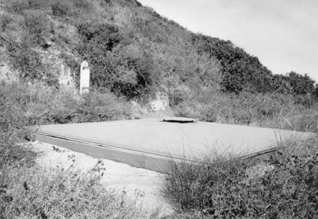
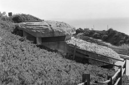
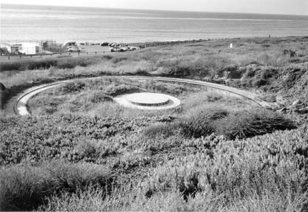
BATTERY BLUFF, NORTH AND SOUTH GUN EMPLACEMENTS (Stabilization)
Location
These gun emplacements, located at the edge of a bluff overlooking San Diego Bay, are reached from the Bayside Trail. Public access is prohibited.
History
Constructed in 1942, this World War II battery consists of two mounts located on the east side of Point Loma, at the edge of a high bluff overlooking the Bay. Serving as an anti-motor torpedo boat battery, it protected the entry channel to San Diego Harbor. Each mount held a 37mm M3E1 gun. An azimuth instrument was mounted on the associated four-foot steel pipe filled with concrete to the north, when the battery was active.
Description
Each semi-circular concrete emplacement is three feet wide and originally two feet high on the inside (figures 26 and 27). Although partially buried, approximately 13-inches of the two-foot high emplacement remains visible. Eight bolts attaching the weapon's base plate are embedded into concrete at the center of the northern emplacement, but if they remain at the southern emplacement, they are no longer visible. Traces of paint are visible on the inside concrete surface of the south emplacement. Remains from associated wood structures are nearby, in addition to the azimuth instrument pole.
Condition
Due to erosion, these two emplacements are now perched precariously at the cliff edge. Both are partially filled in with sand and vegetation. A fissure present in the soil 12-inches in front of the south gun emplacement jeopardizes the structure. Cracks in the concrete mount are visible signs of ground instability. Plant growth is present in one of the surface cracks, accelerating deterioration. The north gun emplacement remains about three feet from the cliff edge. Site instability limits the life span for these structures.
Structural Analysis
The major concern associated with these emplacements is the stability of the cliff-top where they are located. The edge of the cliff is only two or three feet from the front of the north emplacement, and it is only a matter of time before the cliff erodes back to the face of the emplacement. The south emplacement is further back from the cliff-top, however it appears to have settled at the front side and is now slightly tilted. The concrete ring structures themselves are in reasonable condition, although the south emplacement has large circumferential cracks (up to one-half-inch wide) in the concrete.
|
| Figure 27. Bolts to attach the weapon's base plate are visible at the north emplacement. |
|
| Figure 28. An overall view of the Panama Mount looking west toward the Pacific Ocean. |
BATTERY POINT LOMA PANAMA GUN MOUNT (Stabilization)
Location
This structure is located on the west side of Point Loma. Nearby structures associated with these mounts include the bunker complexes and the storeroom/sleeping quarters.
History
In 1939, four 155 mm guns were brought to Fort Rosecrans. Emplacements for the guns were begun on the west side of Point Loma in 1941 when funds became available. The mounts were completed in January of 1942. The guns were emplaced on Panama mounts with a traverse of 360 degrees, located 90 feet apart from center-to-center. An underground communications trench connected the four guns. The guns were actively used during 1941-42, staffed by Battery E of the 19th Coast Artillery. This battery served as the examination or "challenge" battery for ships approaching the water areas to the west and northwest of San Diego Harbor. Following Pearl Harbor, they served as the primary anti-submarine battery. The guns were abandoned in 1943 with the completion of the 90mm AMTB Battery Cabrillo installation. Although three of the mounts are no longer visible, archaeologists uncovered the mount of gun number four during the mid-1980s.
Description
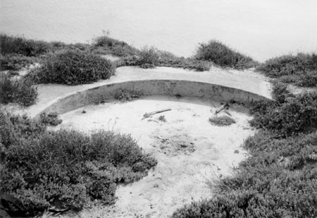
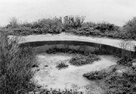
This emplacement consists of two concrete rings. An inner, ten feet in diameter circular concrete base banded with iron located at the center of the emplacement seated the gun. The outer ring is three feet wide and 38 feet six inches in diameter. The guns' trails rested and turned on the steel rails embedded in this outer ring. One of the rails is smooth, the other is toothed. The emplacement is approximately three feet high, although only about 12-inches remains visible (figure 28).
Condition
The only visible mount, number four, was stabilized when it was excavated during the mid-1980s. Stabilization included the treatment and painting of metal elements.
The central concrete portion of the mount exhibits cracking at the beveled edge and across the top surface. The steel band encircling this element is delaminated and the bolts are missing. The outer concrete ring is partially covered at the northeast side due to slope erosion. Some concrete erosion and spalling is present. All metal components show signs of corrosion and are in need of paint.
Structural Analysis
No significant structural concerns were noted. The cracking and spalls in the concrete ring structures are relatively minor and do not at this time appear to compromise the structure's capacity.
|
| Figure 29. Small corrugated metal structures served the four Panama Mounts once here. |
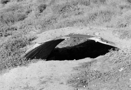
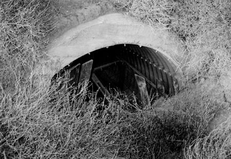
BATTERY POINT LOMA BUNKER COMPLEX, GUNS 1 & 2 (Stabilization)
BATTERY POINT LOMA BUNKER COMPLEX, GUNS 3 & 4 (Stabilization)
BATTERY POINT LOMA RESERVE MAGAZINE
Location
These structures are located on the west side of Point Loma, originally supporting the four Panama gun mounts located nearby.
History
These bunker complexes each consist of five structures; one located to the south of each gun, one to the north of each gun and one to the east situated between the guns. Associated with the Panama Mounts, these corrugated metal bunkers connected to a communications tunnel at the rear of the battery. Actively used from 1941-42, they were abandoned in 1943. The bunkers were either ready magazines, storage facilities or sleeping quarters. The reserve magazine might be the magazine specified in 1936 drawings, with a later conversion into a bunkroom.
Description
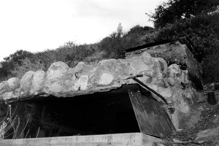
Exterior
Partially covered with earth and vegetation, these quarter-inch thick corrugated metal barrel vault structures range from seven-and-one half to ten-feet long, and are ten-feet wide (figure 29). Exposed corrugated metal, approximately four foot wide panels bolted together, form both the ceilings and the walls of these structures. The panels run the length of the bunkers. Corrugations are six-and-one-half inches on center and about one-and-a-half inches deep. The metal panels are connected with two-inch threaded bolts with square nuts, the joints overlapping about five-inches. Some of these bunkers are almost entirely buried and the interiors of others are relatively free of debris.
The reserve magazine (storeroom/sleeping quarters) is a partially buried, corrugated metal barrel vault covered with a 12-inch layer of concrete (figure 30). Ten-feet wide and forty-feet long, only the ends of the structure are visible, the remainder covered by earth and vegetation, creating an artificial hill.
Interior
One of the bunkers has an intact wooden rear wall constructed of five-inch wide boards with two-inch wide cross pieces. Two collapsed corrugated pipes are inside.
At the reserve magazine, the remains of wood one-by-three inch tongue-and-groove flooring and a built-in wood and chicken wire bunk or storage assembly are scattered about the floor with other debris.
Condition
The corrugated metal bunkers range from partially infilled to almost entirely infilled with earth and vegetation from the site. Their condition is difficult to access. The exterior exposed portions of the metal structures are heavily corroded and the interiors viewed showed signs of galvanization.
Reserve Magazine: the concrete curbs at the base of the walls, which apparently once supported the wooden infrastructure, have collapsed, taking the wooden elements with them. The structures are overgrown with vegetation.
Structural Analysis
No major structural concerns were noted. The wood retaining wall at the north end of the south bunker at Guns 3 and 4 is decaying and does not appear to be well tied to the steel pipe. Several bolts or nuts that tie together the sections of the steel pipe at the reserve magazine structure are missing, however this is not serious. Sections of the concrete support for the wood bed frames have collapsed, however this does not affect the overall stability of the structure.
|
| Figure 30. Collapsed wood and chicken wire assemblies are visible at the entrance. |
| <<< Previous | <<< Contents >>> | Next >>> |
cabr/hsr/architectural-data.htm
Last Updated: 06-Apr-2005