|
Castle Mountains National Monument California |
|
 NPS photo | |
A New National Monument
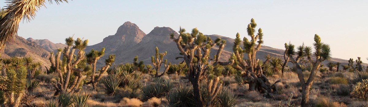
President Barack Obama signed a Presidential Proclamation in February, 2016 creating the Castle Mountains National Monument. Nestled against the border with Nevada and bounded on three sides by Mojave National Preserve, the 20,920 acre National Monument provides serenity, solitude, natural soundscapes and dark night skies. The National Monument protects an expanse of relatively intact desert ecosystem. It provides a wide variety of recreational experiences and opportunities for the public to explore and enjoy including hiking, backpacking, wildlife viewing, scenic driving, as well as opportunities for solitude and personal discovery.
Mojave Desert
An integral piece of the Mojave Desert, the Monument is home to important flora, fauna, water, and historic resources. The Castle Mountains contain resident populations of, and migratory corridors for, desert bighorn sheep and other fauna. It has some of the finest Joshua tree forest and native desert grassland in the Mojave Desert. It also completes the protection of the 226-square mile Lanfair Valley watershed, shielding an aquifer that is critical to life in the desert ecosystem both within the area and Mojave National Preserve. Cultural resources throughout the area reflect a long history of prehistoric and historic human use.
Flora and Fauna
The Castle Mountains National Monument provides a critical linkage for plants, animals, and water between two mountain ranges within the Mojave National Preserve—the New York Mountains to the northwest and the Piute Mountains to the southeast. The Monuments high quality desert habitat includes some of the finest Joshua tree forest in the Mojave Desert, as well as pinyon pine and juniper forest at the upper elevations. The Monuments native desert grassland is a hotspot of botanical diversity. The unique plant assemblage includes 28 species of native grasses, about half of which are rare, such as burro-grass (Scleropogon brevifolius) and false-buffalo grass (Munroa squarrosa). This high concentration of rare plants in such a small area indicates the likelihood of future discoveries of new plants.
With its habitat linkages, wildlife corridors, and intact ecosystems, the area offers exceptional opportunities to study plant and animal movement and connections between diverse natural systems, especially in the context of climate change. Ongoing studies of desert bighorn sheep and other plant and animal species have shown the priority of this area for scientific research.
Geology and Hydrology
Shaped by millions of years of geologic forces, the rugged Castle Mountains are emblematic of the Mojave landscape. Composed of early Proterozoic gneiss and foliated granites, overlain by thick volcanic deposits, the Castle Mountains rise from the broad sweep of the Lanfair Valley to a height of over 5,000 feet, presenting a picturesque skyline visible from many locations within the Preserve in California and surrounding lands in Nevada, while also affording spectacular views of the Preserve and beyond. Hart Peak is the prominent feature in the Castle Mountains National Monument skyline at 5,543 feet.
Underlying much of the Lanfair Valley, including the Castle Mountains National Monument, is a large groundwater aquifer of critical importance to the desert ecosystem. With its primary recharge zone in the New York Mountains, this aquifer feeds Piute Spring located in the Preserve just south of the Monument. Piute Spring is also the only perennial stream and riparian corridor in the Preserve. The Lanfair Valley groundwater basin is a closed system, with recharge entering the upper elevations of the New York Mountains and discharge at Piute Spring. Sampling by the U.S. Geological Survey (USGS) revealed a radiocarbon date for the water at Piute Spring of 6,825 years, indicating that discharge from the spring originated as precipitation in the New York Mountains thousands of years ago during the mid-Holocene epoch.
Human History
Some of the best-preserved segments of a wagon road that linked the Arizona Territory (Hardyville, now Bullhead City, Arizona) to settlements in Southern California can be found in the Monument. Ranchers grazed cattle in the area and, by 1894, the Rock Springs Land and Cattle Company had consolidated its holdings in the eastern Mojave Desert. Much of this historic ranching operation, which has been nominated to the National Register of Historic Places as a historic district, lies within the Monument and Mojave National Preserve. Characteristic features of this ranching era can still be seen on the landscape in the form of corrals and watering troughs.
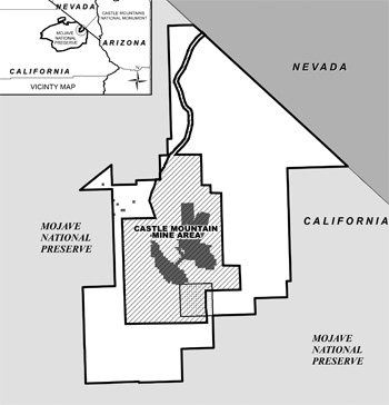 (click for larger map) |
In 1907, likely attracted by the volcanic deposits and igneous intrusions cutting through older rocks, three prospectors, James Hart and brothers Bert and Clark Hitt, found pockets of rich gold ore in the Monument area and staked claims that later became the Oro Belle and Big Chief Mines. By early 1908, the town of Hart had nearly 700 people, a post office, telephone lines, and a weekly newspaper. By the summer of 1908, the population of Hart peaked at around 1500 residents. But the pockets of high-grade ore proved too small, and mining began to decline a year later. The newspaper and other businesses closed, the post office shut down in 1915, and by Prehistoric rock art and archeological sites are found throughout the area, typically associated with travel corridors and important resources which demonstrate the long-term significance of the Castle Mountains area for prehistoric inhabitants.
Planning Your Visit
Operating Hours and Seasons
Hours: Open every day
Entrance fee: No Charge
Directions
Castle Mountains National Monument lies within a few hours drive of several
major metropolitan areas. It can only be accessed by dirt roads. High
Clearance is mandatory, and Four Wheel Drive is highly recommended for
Walking Box Ranch Road. All other Roads require four wheel drive and
high clearance vehicles. Cellphone service is spotty, and there are no
facilities in the monument. Be prepared to be self sufficient with
plenty of water, fuel, and a good working off road vehicle Note: No
ATVs or UTVs allowed in the Monument.
You can access the National Monument from Walking Box Ranch Road off of California State Road 164 (Nipton Road) or from several unnamed dirt roads off of Lanfair Road in Mojave National Preserve.
Source: NPS Brochure (2016)
|
Establishment Castle Mountains National Monument — February 2, 2016 |
For More Information Please Visit The  OFFICIAL NPS WEBSITE |
Documents
Castle Mountains Geology and Gold Mineralization, San Bernardino County, California and Clark County, Nevada (Richard C. Capps and John A. Moore, 1997)
East Mojave National Scenic Area Guide (BLM, undated)
Economic Impact of Designation of National Monuments in San Bernardino County: Sand to Snow, Castle Mountains and Mojave Trails National Monuments (AM Development Group, July 2018)
Geology and Mineral Resources of the East Mojave National Scenic Area, San Bernardino County, California U.S. Geological Survey Bulletin 2160 (Ted G. Theodore, ed., 2007)
Geology and Mineral Resources of the Ivanpah Quadrangle, California and Nevada U.S. Geological Survey Professional Paper 275 (D.F. Hewett, 1956)
Preliminary Geologic Map of the Castle Peaks 7.5' Quadrangle (David Reioux, Benjamin Parrish, Brian J. Swanson and Howard J. Brown, 2022)
Preliminary Geologic Map of the Crescent Peak 7.5' Quadrangle (David Reioux, Benjamin Parrish, Brian J. Swanson and Howard J. Brown, 2022)
Preliminary Geologic Map of the Ivanpah 7.5' Quadrangle (David Reioux, Benjamin Parrish, Brian J. Swanson and Howard J. Brown, 2022)
Preliminary Geologic Map of the Pinto Valley 7.5' Quadrangle (David Reioux, Benjamin Parrish, Brian J. Swanson and Howard J. Brown, 2022)
Presidential Proclamation 9394 — Establishment of the Castle Mountains National Monument (Barack Obama, February 12, 2016)
Springs and Water Resources Inventory, Castle Mountains National Monument NPS Natural Resource Report NPS/MOJN/NRR-2016/1345 (Jennifer L. Bailard, December 2016)
Vegetation Classification at Lake Mead National Recreation Area, Mojave National Preserve, Castle Mountains National Monument, and Death Valley National Park: Final Report (Revised with Cost Estimate) NPS Natural Resource Report NPS/MOJN/NRR-2020/2178 (Julie M. Evens, Kendra G. Sikes and Jaime S. Ratchford, October 2020)
camo/index.htm
Last Updated: 01-Jan-2025