|
Capitol Reef
Administrative History |

|
CHAPTER 12:
GRAZING AND CAPITOL REEF NATIONAL PARK: A HISTORIC STUDY
Livestock grazing has been the most dominant and frustrating resource issue throughout Capitol Reef National Park's history. Because of the inherent conflicts between the local dependence on livestock and the limited-use, preservation philosophy of the National Park Service, grazing management has become a target issue for park managers, neighboring federal agencies, local communities, and single-use advocates.
For all the attention that grazing has received at Capitol Reef, there has yet to be commissioned a comprehensive history of livestock management and its impacts from the 19th century to the present. This history, nonetheless, proposes to answer some of the key questions about the nature, origin, and impacts of past grazing practices, and to describe National Park Service grazing management at Capitol Reef since the area's initial designation as a national monument.
Over the past 100 years, grazing became interwoven into the cultural and economic fabric of south-central Utah. During this time, the desert areas serving as traditional winter grazing range were heavily used and abused. When the National Park Service brought its limited-use philosophy to Capitol Reef in the late 1930s, conflict was inevitable. A lack of National Park Service attention and understanding, together with the agency's desire for quick solutions, exacerbated tensions. The steel of federal preservation management struck against the flint of local lifestyles has sparked ongoing grazing management conflicts at Capitol Reef National Park. Underlying reasons for these disputes must be analyzed and understood if the cycle of lingering conflict is to be broken so a new, more cooperative relationship among all parties can be created.
Chapter 12 is organized into seven sections. The first three sections establish the historical context by discussing how traditional livestock practices and federal grazing management evolved, first in Utah and elsewhere in the West, and then in the Waterpocket Fold country where Capitol Reef National Park is today. It was during this early period that many of the lands now within the national park were altered by a combination of overgrazing, drought, and economic fluctuations. This was also the time when the first regulation was attempted. Those early efforts at grazing management by the U.S. Forest Service (USFS) and what later evolved into the Bureau of Land Management (BLM) have had a significant effect on the livestock industry and the local relationship with federal land management agencies.
The remaining four sections of Chapter 12 primarily focus on grazing management at Capitol Reef as it evolved from a small national monument to a sprawling national park. From the monument's establishment in 1937, through the controversial expansion and park designation in 1971, to the grazing phaseout debates, Capitol Reef managers struggled to find ways to protect lands already used by cattle. By the time a partial buyout of grazing permits was possible in the late 1980s, the previous conflicts had left scars that may persist for years.
The sources researched for this study came primarily from the National Park Service records, Record Group 79, found in Capitol Reef National Park's archives, superintendent's and resource management files, and at the National Archives, Rocky Mountain Region (now, Intermountain Region) in Denver. The records of the Bureau of Land Management, Record Group 49, were also examined in the National Archives, Denver, and at the Henry Mountain Resource Area files in Hanksville and Escalante, Utah. United States Forest Service records pertaining to areas adjacent to Capitol Reef were reviewed in Teasdale and Loa, Utah. The author thanks Keith Durfey for his help in examining these local BLM and USFS records.
Other primary documents came from the Utah State Historical Society archives and the special collections at Utah State University in Logan. Secondary sources and interviews provide additional insight and case examples. For more detailed background information such as a physical and historical description of the Capitol Reef area, see Volume I of this history. Copies of the legislation that established the monument and the park are provided in the appendix to Volume I.
The Evolution of Grazing in
Utah
Vegetation Before the Introduction of Domestic
Livestock
The focus of this study is the history of grazing management, but the actual impact of livestock on the park's natural resources is an important part of this history. Since ardent disagreement exists over the nature and severity of those resource impacts, it is important first to document vegetation changes within Capitol Reef National Park. The information provided here, however, is only a cursory look. For more detailed information, consult the appropriate management documents or specific grazing studies, which are listed in the bibliography at the end of this chapter.
While there have been a variety of historic and scientific accounts describing range conditions throughout Utah and the West, the isolation of Wayne and Garfield Counties prevented the recording of any comprehensive, scientific descriptions of vegetation before the 1930s. The descriptions and oral testimonies used to reconstruct earlier conditions, while illustrative, are not complete or systematic. Nevertheless, virtually every account, whether of Utah in general or the Waterpocket Fold region of Capitol Reef in particular, documents considerable vegetation change over the past 100 years. [1]
Utah's pre-settlement vegetation of the 4,000-to-7,000-foot range of elevation, which describes most of Capitol Reef, is described as follows:
Where the soils and the moisture supply was somewhat more favorable than ordinary, as along stream courses, the wheatgrasses and giant ryegrasses predominated. On drier sites sagebrush was proportionately more abundant but bore grasses between the sages in considerable amounts. Practically always the plant cover was dominantly a mixture of wheatgrass (or ryegrass) and sagebrush. [2]
The first known written description of Utah came from the journal of Friar Francisco Silvestre Velez de Escalante. Escalante, along with his fellow Franciscan, Francisco Atanasio Dominguez, circled around the Colorado Plateau in 1776. According to the journal, Utah Valley, near present-day Provo, contained bountiful "pasturage" that recently had burned. Escalante postulated that the area's native inhabitants were burning the grasses to prevent the friars' party, with its small herd of horses, from entering their lands. There are many accounts of American Indian people burning areas to maintain grasslands and otherwise manipulating natural resources well in advance of European settlement. [3]
Closer to Capitol Reef, Dr. Almon H. Thompson, who led John Wesley Powell's 1872 survey party through the Waterpocket Fold, commented that the abundant grasses on Boulder Mountain would someday be "a perfect paradise for the ranchers." [4] Expedition photographer Jack Hillers described the lush grasses and evidence of the first known cattle to graze in the vicinity of lower Pleasant Creek, perhaps within today's park boundaries:
This is the great hiding [place] of the Indians and many heads [of cattle] have found their way in here, all stolen from the Mormons, who never suspected for a moment that their friends the Utes would do the like, but thinking the Navajos the guilty party....They never dreamed that here the Indians feasted on broiled steak. Wild oats grow here the same as cultivated does anywhere else but not so heavy. [5]
Many of the first ranchers in southern Utah also recalled abundant, tall grass. Dixie National Forest Ranger William Hurst documented a 1935 conversation with Elias Hatch, one of the original ranchers in the area. Hatch recalled that, prior to livestock grazing on the eastern boundary of the forest, there was no sagebrush on nearby mountains, and forage consisted of "a heavy stand of pershia, snowberry, choice grasses, and weeds." [6]
Ranger Hurst noted that this description was accurate, supported by numerous other ranchers and by his own observations. Iinterviews corroborate the latest scientific evidence that range vegetation at Capitol Reef itself has changed during historic times.
For instance, the monument's first superintendent, Charles Kelly, recorded the observations of several older ranchers regarding the altered condition of the range. For instance, Kelly made one trip east of Hanksville in the company of an old cowhand, Court Stewart (whose name is inscribed in Capitol Gorge). Stewart looked at some rather bare ground and commented that, when he was a kid, that spot -- in fact, the whole desert -- "had grass on it that would rub the stirrups on a horse." [7]
Howard Blackburn, another early cattleman in Wayne County, also remembered the land before settlement. Blackburn told Kelly in 1946 about his first trip through what is now the heart of Capitol Reef National Park, in about 1881:
Sulphur Creek was then a tiny stream and had cut no canyon. Dirty Devil river was not more than a rod wide, its course thickly lined with willows. Most of the valley at Fruita was covered with a heavy growth of squaw bushes...The whole country, now an almost barren desert, was then heavy with tall grass. [8]
These accounts and a glance at the landscape today suggest that the vegetation covering the ranges of Capitol Reef has indeed substantially changed. The rugged, slickrock nature of the region has naturally limited grazing to the flatter, more open areas on the flanks surrounding the towering Waterpocket Fold. Grazed lands in the northern Cathedral Valley, southern Sandy Creek, Bitter Creek, and Halls Creek areas have always supported sparse vegetation. Yet, where bunch grasses and willows once dominated, cheatgrass, snakeweed, and tamarisk (all exotics or recent invaders) have become abundant. Large areas of grasses grow in some locations, while other areas have a few grass clumps only a couple of inches high. [9]
Based on analysis of preserved plant remains, Kenneth Cole's 1992 "Survey of Fossil Packrat Middens" offers a scientific reconstruction of vegetation cover prior to domestic livestock grazing. Cole cautions that his examination of packrat middens in the Hartnet Draw area in the northern end of the park and the Halls Creek drainage in the southern end of the park is not definitive. Nevertheless, he did establish that the vegetation collected by packrats for constructing their nests changed dramatically over the past 100 years. This change reflects the availability of plants in the local environment, where the rodents collect their materials. While Cole noted some cyclical change among the older varieties, such as certain grasses, pinyon, and winterfat, he observed:
None of the Presettlement middens are as different from the other Presettlement middens as are The Postsettlement middens. This suggests that recent changes in vegetation have been more severe than previous natural changes. In particular, at Hartnet Draw, where the time series of middens near one site yield the most reliable results, the vegetation changes occurring the last 100 years were more severe than any that had occurred during the prior 5400 years. This perspective of natural variation emphasizes the extreme severity of the recent vegetation changes. [10]
The fact that plant communities covering the arid plateau lands of southern Utah have changed is well substantiated. What now needs to be established is exactly how and when the changes occurred. If grazing caused today's comparatively depleted or altered rangeland, did these changes occur recently, historically, or cumulatively? What activities or policies caused the present landscape legacy? By placing grazing at Capitol Reef into its historical context and developing an understanding of when and how livestock management has evolved in the Waterpocket Fold country, present and future managers at Capitol Reef will be better equipped to make long-range policy decisions.
Early Utah Settlement and Grazing Patterns
The organized Mormon settlement of Utah, being different from settlement elsewhere in the American West, has left distinctive imprints on grazing history. The early communal herds, a spiritual belief in land stewardship, and significant control by Mormon Church officials resulted in a different tradition of grazing practices here. Yet, despite the best of intentions, the abundant ranges of Utah began to see almost immediate depletion This resulted from a lack of knowledge about arid environments, the influx of large, non-Mormon owned herds, and the rapid "Americanization" of Mormon grazing practices that ensued. [11]
The first arrivals to the foothills east of the Great Salt Lake in the late 1840s were from the Midwest, as were the stock they brought with them. Geographically isolated from new livestock breeds and the spread of customs dubbed the "Texas Invasion," Utah Mormons were able to establish their small herds in Utah before the huge, non-Mormon-owned herds arrived in the 1870s. [12]
The first outlying settlements north and south of Salt Lake City were founded near rivers emerging from the Wasatch and Oquirrh Mountains. Factors considered when deciding the suitability of a new settlement site included:
The presence of good soil, water enough for irrigation and for livestock, and timber supplies suitable for buildings, fences, fuel, and farm uses, and native forages for feed....The agricultural needs of the Mormon people founding Utah were (a) for areas of dependable land for cultivation, (b) irrigation water, (c) for nearby forage suitable as feed for horses, oxen, and farm livestock, and (d) sufficient range forage in the mountains, foothills, and semidesert valleys not immediately adjacent to the settlements to support range livestock. Permanent occupation depended in a large measure on the proper combination of all four of these resources. [13]
Since most of the meager lumber supply was used for house and barn construction, and because the settlements were springing up so quickly, the individual herds of cattle and sheep were gathered into common grounds for community herding. [14] Most Mormon families had at least a few head of cattle and sheep producing milk, cheese, wool, and meat. Customarily, groups of boys would assemble the numerous small herds each morning, and range the stock "on the nearby foothills in summer or flats in winter," bringing them back in the evening. [15] This kind of cooperative, town-based herding was distinctly different from the Hispanic and Texan traditions of expansive, open range ranching that were adopted elsewhere in the West throughout the 1860s and 1870s. Most distinctive of Mormon ranching practices, however, was the role of the church in governing the range and molding cultural attitudes towards the land.
Mormon Cultural Influences on Grazing
The Church of Jesus Christ of Latter-day Saints inarguably established among its members a certain regard toward the land. It also created a kind of Mormon perspective, which viewed "outsiders" as threatening to property rights and traditional lifestyles.
Like many rural residents of the American West, Mormon livestock owners viewed the land in terms of its economic potential. To the settlers of the arid and semi-arid landscapes that predominate throughout Southern Utah, the country was economically useless except for grazing. A strong spiritual confidence and the need to succeed and spread motivated church members to ranch on the forbidding open lands of Southern Utah -- and to make those lands produce. Modern resistance to preserving these public lands as wilderness or national parks is rooted in these same religious and economic motivations.
Many biblical references are interpreted by Mormons as ordaining their settlement of Utah. Perhaps the clearest is Isaiah 2:2: "And it shall come to pass in the last days, that the mountain of the Lord's house shall be established in the top of the mountains, and shall be exalted above the hills; and all nations shall flow unto it." [16]
Once settled in Utah, the Mormons looked at these new, unclaimed lands as their own, to be used in the wisest, most prudent manner that would benefit the individual and the church. The Mormon Doctrine and Covenants states:
[T]he fullness of the earth is yours, the beasts of the field and fowls of the air, and that which climbeth upon the trees and walketh upon the earth; Yea, and the herb, and the good things which come of the earth, whether for food or for raiment, or for houses, or for barns, or for orchards, or for gardens, or for vineyards; Yea, all things which come of the earth, in the season, thereof, are made for the benefit and the use of man, both to please the eye and to gladden the heart;...And it pleaseth God that he hath given all these things unto man; for unto this end were they made to be used, with judgment, not to excess, neither by exhortation. [Emphasis added.] [17]
This belief that the lands were for man to use as he saw fit was tempered by strict control by church officials, which in theory should have preserved the natural resources of Utah. Historian Dan Flores writes:
With their centralized leadership and their belief that the earth and all its products were the property of a divine entity, the Mormon brand of stewardship was at once less theoretical than Christian stewardship. Individual Mormons, for example, dedicated land and projects to the divinity. Additionally, the doctrine of continuing revelation was not only a boon for coping with a new environment, but endowed church decrees on natural resources with the power of supernatural sanction. The Mormons thus provide the closest American experience of the Judeo-Christian stewardship ethic, or the 'Abrahamic Land Concept,' in action on a pristine Frontier. [18]
Perhaps the most significant outlook toward the lands of Utah by the Mormons, however, is the attitude that the land was theirs and could not be taken from them. Again, this is a belief shared by many early settlers, as well as 20th century residents of the West. Yet the perception of persecution and identification as a chosen people would reinforce the Mormon belief that they should resist outsiders entering their lands and attempting to manage their livestock and lives. The Book of Mormon states:
Wherefore, this land is consecrated unto him whom he shall bring.... And behold it is wisdom that this land should be kept as yet from the knowledge of other nations; for behold, many nations would overrun the land, that there would be no place for an inheritance. Wherefore I, Lehi, have obtained a promise that inasmuch as those whom the Lord God shall bring out of the land of Jerusalem shall keep his commandments, they shall prosper upon the face of this land; and they shall be kept from all other nations, that they may possess this land unto themselves. And if it so be that they shall keep his commandments, they shall be blessed upon the face of this land; and there shall be none to molest them, nor to take away the land of their inheritance, and they shall dwell safely forever. [19]
Thus, not only is the land rightfully theirs, but so long as Mormons remain in good faith, the use of that land can not be taken from them. This notion is reiterated in the next passage, which warns that God would "bring other nations unto them, and he will give unto them power, and he will take away from them the lands of their possessions, and he will cause them to be scattered and smitten" if his people were not faithful. [20]
Utah, unlike the other Western states where grazing would begin to dominate in the last quarter of the 19th century, was established on firm religious grounds. Here, the earth itself was consecrated to the Mormon settlers as a chosen people, and promised to them for as long as they remained faithful and good stewards of the land. Such strong belief in the rights of Mormons to be the stewards of these chosen lands also helps explain why many Utah ranchers view all their traditional grazing lands, whether on federal lands or not, in terms of private property rights.
Despite the good intentions of the original Mormon settlers of Utah and the controlling influence of church officials, the lands grazed by the Mormons' cattle and sheep quickly began to deteriorate, even before the invasion of "other nations."
American Indians were noticing the decline in grass and wild animals as early as the 1850s, and overgrazing was noticed by the Mormons themselves a decade later. Apostle Orson Hyde of Sanpete County (30 miles north of Capitol Reef National Park) warned the General Conference of Saints in 1865 of a deteriorating range:
I find the longer we lie in these valleys that the range is becoming more and more destitute of grass; the grass is not only eaten up by the great amount of stock that feed upon it, but they tramp it out by the very roots; and where grass once grew luxuriantly, there is now nothing but the desert weed, and hardly a spear of grass is to be seen. [21]
The eastern and midwestern farming methods used by most early Mormons were not appropriate to the arid, Western landscape. Again, according to Flores:
Even before the rush of individualistic Gentiles into the territory, Utah's environment was showing signs of deterioration. In its efforts to provide for the growing numbers of converts by making 'the desert bloom like a rose,' the Mormons decidedly overstrained the fragile Wasatch environment. Accustomed to eastern conditions and lacking scientific knowledge of plant succession, or the relationship between water, vegetation, and slope, and forced increasingly both to provide for larger numbers and compete for resources with non-Mormons, the church could not develop a land ethic. [22]
The arrival of huge cattle and sheep herds during the 1870s and 1880s not only worsened the problem, but forever changed livestock management in Utah.
Large Herds and the "Americanization" of Utah
Grazing
Beginning sometime in the 1870s, large herds were pushed onto Utah's open range, where only a few small, cooperative herds grazed before. The move was slow in starting, again due to Utah's geographical barriers. There was an increase from 39,180 cattle, reported in the 1870 census, to 132,655 in the 1880 census. Yet, at the same time, neighboring ranges in Colorado, Wyoming, and Montana were supporting well over twice that many cattle, most driven north from Texas. [23]
The 1880s saw the real boom in livestock numbers as cattle jumped to 200,000 by 1885 and nearly 420,000 by the middle of the 1890s. Meanwhile, sheep were also being driven into Utah at an alarming rate:
From the modest beginnings of only a few head per farm, sheep increased so rapidly after 1875 that the ranges of Utah were supporting one million head by 1885; nearly two million in 1895; 2,600,000 in 1905. [24]
According to all available accounts, this dramatic increase in livestock at the end of the 19th century was due to arrival of several large outfits financed by eastern and English capital, and to local Mormons increasing their own herds to compete on lands that were previously theirs, alone.
The federal Works Progress Administration history of grazing in Utah, compiled during the late 1930s, blamed these invading herds for much of the damage to Utah's ranges:
[T]he system of handling livestock during the boom days was simply no system at all, first come - first served, during any season of the year....This country to all appearances was yearlong range in the eighties, and it would no doubt have continued to be such and supported many head of cattle had not the large eastern companies come in. There can be no doubt but that these companies came in to get all they could, utilize the virgin range and cash in on it. [25]
Yet throughout this era, the small Mormon ranchers with herds of only a few hundred cattle continued to be the dominant operators. The extremely large herds of cattle and sheep were owned by only a handful of powerful operators "who ruthlessly grabbed all they could, while they could -- and unloaded." [26]
The Works Progress Administration estimated that there were only four large companies with over 50,000 head of cattle each. The next class of owners, about 50 total, included those holding 1,000 to 5,000 head. The majority of livestock owners continued to be those owning only a few head "that were incidental to farming...in which case they were regarded as cattle men and not farmers." [27]
Both the WPA Grazing History and the respected historian Charles Peterson have blamed these large herds for the beginning of overgrazing. Utah ranchers, responding to outside competition, increased the size of their own herds and adopted herding practices common throughout the rest of the West. Historian Flores argues that non-Mormon pressure on Utah's resources caused Mormons to lose their "affection for egalitarianism." He explains:
When [Brigham] Young's death in 1877 removed the major advocate of the old order, Mormons in Utah began a process of Americanization....Although separation of church and state and abandonment of plural marriages were the most symbolic reforms required to 'bring the territory into conformity with national standards,' Americanization in process had meant a tacit recognition that resource use was a matter of competition rather than 'state' planning. [28]
In response to pressure, Mormons abandoned the old, church-encouraged stewardship and their small, cooperative herds in favor of larger, mobile flocks of sheep and cattle that could better compete for remaining ranges. The effect of this change was an "Americanization" of grazing in Utah and an even more rapid deterioration of the fragile, arid range.
The large outfits entering Utah during the 1880s included those of Preston Nutter, who ranged cattle west and north of the Colorado River; the Pittsburgh Company, which took over some of the small ranches around La Sal; and the Carlysles from England, who bought out ranches near the Blue Mountains. Closer to Capitol Reef, many of the larger ranches that had started up during the cattle boom days of the 1880s were developed by Mormons. The Scorups, from Salina, used a great deal of range east of the Waterpocket Fold. Another Utahn, Will Bowns, of Sanpete County, developed the Sandy Ranch a few miles south of Notom. Other ranches founded around the Henry Mountains around the turn of the century included John A. Burr's Granite Ranch, and the Starr, Fairview, and Trachyte ranches, some of which were Mormon-owned. [29]
Interviews conducted for the WPA grazing history give a clear picture of the competition between the large and small outfits. Niel Ray, of Moab, recalled:
These first settlers were not trying to become big cowmen, they only wanted enough cows to give them a good living, and they wanted to keep it that way and have the range like it was to pass on to their children and grandchildren. But even before 1900 the eastern companies started buying out the little fellows and after that they had big outfits, run by foremen, and hired riders from out of the community. These riders were tough hombres, many of them wanted by the law in Texas, Oklahoma and those places. [30]
Non-Mormon livestock companies pressured ranchers around Capitol Reef, too. Guy Pace, a long-time Wayne County rancher, describes the situation:
On the winter ranges [east and north of Fruita] we were getting operators from all over. Coming in from Colorado and everyplace. Just coming in. See, there was no controls at all...And people that had big herds of livestock [were] coming from all over, providing there was grass. It was a result of that, see, it depleted the ranges to beat hell. [31]
Regardless of whether range damage was caused by the large herds coming in or by the local, Mormon-owned herds, these large cattle and sheep companies left their mark on local culture, its oral traditions and, of course, the range. Southern Utah was particularly affected:
In this wonderland the large cow outfits like the Carlysle, Pittsburgh, and Elk Mountain existed for a decade and left history colored with long ropes, fast horses, smoking six guns, Robbers Roost, outlaw gangs, and blood. Texas cow punchers, Texas cattle, and Texas methods were introduced. The punchers grew in number; the cattle were rapidly bred away from the longhorn strain; and the old methods could not be used. [32]
There was also a general mixing of the wild Texas cattle culture with that of the more reserved Mormons. Charles Peterson wrote:
Young and full of life, cowboys invaded the Mormon towns socially. As a local folksong put it, they drank at Monticello's Blue Goose Saloon, traded with Mons's store (the town's only mercantile institution) and 'danced at night with the Mormon girls.' Occasionally there was gunplay....More important was the fact that a dozen or so outside cowboys married Mormon girls. Frequently these men stayed in the country where they became the relaxed channels through which Texas and Mormon customs evolved. [33]
This "Americanization" of grazing in Utah thus resulted in social, cultural, and economic changes that have lingered to the end of the 20th century. Perhaps the most significant of these changes was the adoption of the Texas style of ranching, which encouraged larger herds, running virtually wild, with few roundups or closely guarded water supplies. This altered the traditional Mormon pattern of small, cooperative herds, closely watched and often turned in toward town or the base ranch on a regular basis. Instead, sheep and cattle herds, in excess of natural carrying capacities, were moved to pasture earlier and earlier in the spring to claim what was left of the diminishing grasses. [34]
The federal Works Progress Administration study of grazing in Utah used interviews with hundreds of "stockmen, authorities and students of the range" to establish a maximum carrying capacity for Utah of 300,000 cattle and 2 million sheep. These levels were reached sometime in the 1890s. [35] Yet, figures showed that there were as many as 420,000 head of cattle in 1895 and a gradual increase to over 500,000 by the peak year of 1920. Meanwhile, sheep numbered 2 million in 1895, increased to 2.6 million 10 years later, and then fluctuated in number before reaching peaking at over 3 million head "crowding the arid, desert winter feeding grounds." [36]
There is ample testimony that the stiff competition between livestock herds destroyed range conditions and introduced new, invasive plant species by the turn of the century. According to information the WPA gained from the United States Forest Service:
The livestock industry in this section [of the intermountain region] reached its peak as far as numbers were concerned around the turn of the century. Practically every available foot of accessible range was being intensively used. It was: first there, first served....All this time the condition of the vegetation was forgotten. Feed for the current year was the by-word. There was a race to reach the feed. Stock were placed on the range too early and in too great numbers. Summer range was at a premium and the stock were often left on the range too late in the fall....This was no fault of any stockman and no criticism is due him for the conditions that prevailed. The range was there and was free to the man who got it. [37]
Glynn Bennion, who ranged cattle throughout central Utah, recounted:
Rush Valley was all a beautiful meadow of grass when we came here with stock in 1860; but in less than 15 years she was all et out, and we had move to Castle Valley...If you pass through the old livestock-growing communities of Utah you may think that those big old houses date back to the days of polygamy. Maybe so, but they also date back to that period in the life of every Western community when the grandfathers of the present tumble-down generation were making money hand over fist off the virgin ranges. The descendants aren't making any money now off the ranges their ancestors ruined. [38]
Bennion went on to discuss the changes in vegetation as a result of overgrazing:
A resurrected pioneer couldn't even recognize the present desert flora. It bears scarcely any relation to that of 1860. For as the pioneer flocks killed out the best forage types, other plants of less flavor and nutrition took the vacant place in the sun. Then the grazing herds lowered their standard of living and 'took' the poorer forms. Again the flora was changed to still worse types until by progressive deterioration we have the bitter, spiny, worthless kinds of today. [39]
At approximately the same time, the geologist Herbert C. Gregory documented deteriorating range conditions around the Kaiparowits Plateau, southwest of Capitol Reef:
In crossing the Kaiparowits in 1915 grass for horses was abundant along the Wahweap, Warm, and Last Chance Creeks, and the mesas and dun-colored areas east of Paria....In 1922 there was insufficient forage for pack trains at all places except in the sand dune areas of the Escalante Valley. In September, 1924, no grass or browse of any kind was found in the unfenced areas of Boulder Valley and about Canaan Peak. There is no doubt that the Escalante and Paria Valleys and the Kaiparowits Plateau have deteriorated as pasture lands during the last decade, and it seems unlikely that they can be restored to the state existing during the period 1875-1890. Some system of reservation seems most likely to bring improvement. [40]
From the beginning the Mormon livestock industry affected the range. Then, the invasion of large, out-of-state cattle companies and the infusion of large sheep herds stimulated the local small ranchers to raise their own herd limits to meet the rising competition. The public lands that could be used for grazing seemed unlimited when the Mormons first arrived. Yet, by the first decades of the 20th century, not only was all the possible range being used, but competitive herding practices were reducing the carrying capacity of grazed lands at an alarming rate. Significantly, however, while livestock management practices changed during the booming 1880s, the spiritual and communal nature of the Mormon residents would remain the same. So would their resistance to outside government officials determining the fate of their chosen lands.
Origins Of Federal Grazing Regulation, 1880 To
1936
After The Boom: Economic And Range
Deterioration
As was typical in the turn-of-the-century West, it was economics -- not the actual destruction of the landscape -- that eventually led to calls for change.
By the 1870s, the American economy was coasting toward tremendous expansion, and livestock speculation went along for the ride. The rapid advance in transportation by the railroads and growth in the eastern population helped fuel the cattle boom discussed above. In 1879, ordinary range stock sold at about $8 a head by the herd. Only two years later, the price was $12, and the scramble for more ranches and more land was fueled by speculators from around the world. [41]
At the same time, favorable weather patterns lulled many novice ranchers into a false sense of security. All this would change with the infamous winter of 1886-87. While it is unknown exactly what effect this winter had on southern Utah, hundreds of thousands of head of cattle and sheep throughout the American West were lost to starvation and sub-zero temperatures. When the winter was over, the industry was devastated:
Cattle that had been valued at from $30 to $35 on the range sold for $8 to $10, if they sold at all. The 'range rights' were found to be fictitious, and the free grass, if not gone, was going under fence now very rapidly. The holiday and fair-weather ranchman and remittance men suffered along with the real cattlemen. [42]
After this "big die-off," the overstocked, overgrazed lands were subjected to several years of abnormal drought. Most large, speculative cattle operations folded by the end of the decade, leaving the smaller and mid-sized cattle ranchers to fight over the remaining public lands. [43]
Early Public Land Policy
One of the most oft-debated aspects of Western history is the role of federal public land development policy in shaping, or failing to shape, the Western public domain. The most widespread interpretation is that the disposition of federal lands from the 1780s, through such legislation as pre-emption and homestead acts, was undertaken for political reasons having little bearing on practical reality. These laws, ill-suited to the West, pitted settler against rancher or rancher against rancher, with speculation, land wars, and overgrazing as the lasting legacy. [44] As land-use policy historian Phillip Foss observes:
This incalculable waste of resources and human life was not a consequence of the forces of nature: nor was it a consequence of the operation of economic forces through the market and the price system. It was basically and fundamentally a result of political decisions which ordered social forces in such a manner as to disturb the balance of nature. [45]
While the bloody range wars did not happen in Utah, thanks to its homogeneous and church-governed majority, ardent competition for mountain and desert ranges resulted in the destruction of vegetation. Even after the removal of many of the huge herds by 1900, the damage to the landscape was, literally, coming into Mormon homes as floods.
Throughout the rest of the 19th century and into much of the 20th, towns and cities have been inundated by flood waters no longer checked by deep-rooted grasses. Manti reported nine devastating floods between 1888 and 1909, and the years 1923 to 1930 saw a total of 16 Utah counties suffer from floods much larger than ever seen before. [46] Around the Capitol Reef area, these floods had a significant impact on settlement:
Depletion of the range up country and the ploughing of banks practically to the water's edge, increased volume of floods and the result was a severe lowering of the stream bed. By the turn of the century, Mormons along the Fremont below the reef found that much of their farm land had caved away to be washed downstream and that the river itself was dropping below the level of the headgates. The result was a contraction of the original frontier of settlement as people began to move away. [47]
The combination of these floods with the depleted range conditions, continued poor livestock prices, and uncontrolled use of the public domain finally forced Congress to begin looking at regulating the federal grazing lands.
The first comprehensive examination of Western land use problems was completed by John Wesley Powell in 1878. His Report on the Land of the Arid Region of the United States proposed a new system of large, self-regulated ranching units:
The grasses of the pasturage lands are scant, and the lands are of value only in large quantities.
The farm unit should not be less than 2,560 acres. The division of these lands should be controlled by topographic features in such manner as to give the greatest number of water fronts to the pasturage farms.
Residences of the pasturage farms should be grouped, in order to secure the benefits of local social organization, and cooperation in public improvements.
The pasturage lands will not usually be fenced, and hence herds must roam in common.
As the pasturage lands should have water fronts and irrigable tracts, and as the residences should be grouped, and as the lands cannot be economically fenced and must be kept in common, local communal regulations or cooperation is necessary. [48]
These suggestions for future grazing control were undoubtedly influenced by his years in Utah observing early Mormon cooperative practices. In essence, they later became the foundation for the Taylor Grazing Act in 1934. Between 1878 and 1934, however, there were few actual attempts to institute federal grazing management, except within the national forests.
The Forest Service Experiments With Grazing
Reform
In order to place this study of Capitol Reef National Park's grazing history in context, it is important to examine how other federal agencies in the area have managed their grazing lands, particularly those later included in the national park. The U.S. Forest Service became the first federal grazing manager.
The first forest reserves were set aside by President Benjamin Harrison in 1891, as authorized by what is known as the Creative Act passed that same year. Just what would be done with these resources was not established until the late 1890s.
In 1897, in a pattern often repeated in the years to come, Western livestock industry fears of over-regulation (brought on by President Cleveland's unexpected addition of 21 million acres of forest reserves) prompted Congress to restrict the Department of the Interior's authority to enforce land management. (The forest reserves were not transferred to the Department of Agriculture until 1905.) To ensure future appropriations, initial attempts to dramatically restrict sheep grazing were softened. Cattle were not seen as a threat to national forest resources until later. [49]
For example, early attempts to prohibit sheep in some reserves suffering from overgrazing were abandoned. Instead, a system of free permits would be used to regulate sheep numbers and period of use. However, because there was no way to enforce the permit system, sheep continued to roam the reserves as before. [50]
By 1902, Theodore Roosevelt was in office and his friend, Bureau of Forestry Director Gifford Pinchot, was a rising influence in grazing management. Pinchot realized that unregulated competition between various livestock ranchers was depleting timber and watersheds. He believed that any grazing policy must include some kind of regulation, rather than prohibition and "resting upon cooperation among the user interests themselves." [51]
The Department of the Interior, in a desperate attempt to rectify its previous attempts to manage the range, patterned its new grazing regulations after Pinchot's suggestions. A 1902 circular, issued by the department to help explain its new permit system, said that preference would be given to those who lived within or owned stock ranches adjacent to the forest reserve. Local woolgrowers' associations would recommend which ranchers received permits. This kind of self-regulated permit system favoring the local, established livestock operator, would dominate federal grazing management policy for the rest of the 20th century. [52]
When the forest reserves were transferred to Gifford Pinchot's Department of Agriculture in 1905, the management policies did not appreciably change. The concerns of the now national forests were to "break down the opposition and hostile attitude that sheep and cattle men held" and at the same time "discharge faithfully the responsibility of protecting and perpetuating the priceless natural resources." [53] The solution, according to the WPA Grazing History, was to establish "the first national forest advisory boards in Western range history, for the purpose of hearing by local forest officers the problems of allotment of range, numbers of stock to be grazed, adoption of special rules dealing with local conditions, etc." The history continues, "As soon as this provision was made, stock associations were formed on all the national forests. The stockmen welcomed these organizations and practically all the national forest permittees were represented on the advisory boards. Some of the original national forest livestock associations which were formed in Utah and Idaho are still in effect." [54]
These local advisory boards, made up of permittees elected by their peers, worked with the forest officials in granting permits, establishing allotments, periods of use, and carrying capacity for cattle and sheep. Information about local patterns and needs was the primary reason for the advisory boards. It was not their role to establish or enforce U.S. Forest Service policy. The advisory boards did, however, ensure the local ranchers' perceived right to graze as many head of livestock as possible. [55]
For example, in southern Utah:
The allowance for the Aquarius Forest [the western part of Dixie National Forest] for 1907 was 11,000 head of cattle and 55,000 head of sheep. Cattle season April 15 to November 15 and sheep season lambers May 12, others June 25 to October 20. All applications for cattle and sheep were approved. All sheep applications were approved except those which applied for more than 3,000 head. [56]
Livestock numbers were sustained on the already depleted range, according to Dixie Forest ranger, in an effort to protect "the principal resource of income in Southern Utah." The ranger believed that, had the USFS in 1910 abided by established carrying capacities at that time, the range in 1935 would have supported more livestock. [57]
U.S. Forest Service officials recognized that local economic and social conditions had to be considered when determining the uses of federal lands. From the outset of the forest reserves, it was obvious that range management would be successful only if the ranchers themselves were involved. Contributing to this philosophy was the fact that most if not all the forest rangers during this time were from the local communities. While the advisory boards helped legitimize grazing policy in the national forests, the result was an inability to close off the range to ensure resource recovery. In short, grazing management in the national forests necessitated compromises by the users and federal agencies, while the resources themselves were compromised. This situation would arise again with the implementation of the 1934 Taylor Grazing Act.
Economic Problems And Regulation Of The Pubic Domain:
1918-1934
Following the establishment of national forest grazing policies, members of Congress attempted to pass legislation that would create a similar permit system on the rest of the public domain. Resistance from the woolgrowers, jurisdictional disputes between the Departments of Interior and Agriculture, and the lingering belief that the remaining public lands needed to be partitioned by the traditional homestead method, prevented action. [58]
By the 1920s, little had been done to correct range abuses, and the climate for regulation had only worsened. Grazing fees in the national forests had been low since their inception in 1906. [59] By 1918, range conditions had apparently improved enough "to charge a rate which was more in line with the benefits derived." [60] After World War I, however, congressional committees searching for ways to pay the war debt fingered grazing fees as a promising means of raising revenue. While the forest service stalled for time by urging new studies, stockmen opposed to the escalating fees "took advantage of the controversy over grazing fees to make things as uncomfortable for the forest service as possible." [61]
Congressional subcommittees were dispatched out into the field to hold hearings, which turned out to be forums for those dissatisfied with forest service grazing management. These hearings raised the hopes of stockmen that fees would be lowered or even abolished, and awoke the conservation groups who rose in opposition to any change in U.S. Forest Service operations. Historian Foss writes:
The net effect of the investigation appears to have been a weakening of the position of the forest service and a postponement of much-needed regulation of grazing on the public domain. As a result of the forest service fee controversy Western stockmen were more distrustful than ever of federal regulation. The same fee controversy convinced eastern conservationists that the stockmen were out to loot the public domain and that no legislation should be enacted which would in any way accrue to their benefit. And the range continued to deteriorate. [62]
Conditions might have remained in this state for many more years if not for a post-war livestock recession that led directly into the Great Depression. A lot of the Western livestock industry's anxiety over increased grazing fees during the 1920s was due to the agricultural slump after the war. The lower demand for meat and wool caused prices to fall and forced livestock owners to sell at basement prices. It seemed to many ranchers that the worst of the crisis was over in 1930. Then the Depression hit, coupled with an extended drought throughout the West, and the livestock economy appeared doomed. Ranchers must have been disheartened to see their smaller herds forced to graze on range that should be improving but which, because of the drought, was actually deteriorating. [63]
Many ranchers have claimed that drought did more to damage the range than overgrazing. [64] Others, such as to Utah rancher Glynn Bennion, saw things differently:
If the range be considered the principal part of the grazer's capital stock, then we grazers have just about finished consuming our capital. We've got nothing much left to do business with. And all the time we've been kidding ourselves that we could eat our cake and have it. 'It's the drough[t],' we say when looking sourly out upon a depleted range. 'If we could only get the rainfall they used to have.' Let's quit kidding ourselves. [65]
The Works Project Administration's history of grazing in Utah found a depressing scenario for the state's livestock industry:
Ranchers and stockmen who were mortgaged were in many cases closed out, a good many turned their sheep, cattle or ranches over to the banks voluntarily; not however, until after they had been harassed beyond their endurance and could see no future ahead. Those who had kept their property unencumbered and now needed money and credit were unable to obtain it. The years from 1930 to 1934 were the darkest in the history of the livestock industry, and from the viewpoint of the men themselves, the darkest years in the history of local endeavor. Their resources were exhausted; there was nobody or no place to turn. They were finished and merely to watch their animals starve to death. [66]
In Utah and throughout the rest of the West, the stockmen were in such a weakened state that they no longer fought, and in many cases welcomed, federal grazing regulations for the remainder of the public domain.
The Taylor Grazing Act: Passage And
Implementation
By 1934, the economic and climatic devastation of the Depression years combined with the New Deal belief in federal assistance to make grazing reform inevitable. With many of the national livestock associations urging reform, and with Secretary of Agriculture Henry Wallace and Secretary of Interior Harold Ickes in strong favor of complete federal control of the remaining public domain, all that was left to decide was the exact wording of the enabling legislation. [67]
There was some reluctance among Western states to give up hope for some control of the lands, but the states had little budget or manpower to manage what lands they did control. Taking on marginal grazing lands would add to the burden. Utah Governor George Dern observed, "The States already own, in their school-land grants, millions of acres of this same kind of land, which they can neither sell nor lease, and which is yielding no income. Why should they want more of the precious heritage of desert?" [68]
In order to win the state-control advocates over to the Taylor Grazing Bill, Secretary Ickes promised to deliver Civilian Conservation Corps crews to help develop range improvements, such as fence, water holes, and stock driveways, in the more impoverished areas. He would do this, though, only if the range was under federal regulation. [69]
While the grazing reform bill sponsored by Congressman Edward T. Taylor (Colorado) was moving through the House with relative ease, Western senators, traditionally opposed to any federal regulation of land use, set about to block its path. The summer of 1934, however, saw the worst dust storms in the country's history, which weakened the last resistance to the Taylor bill. The Taylor Grazing Act was passed by the Senate on June 12, 1934, and signed into law by President Franklin D. Roosevelt on June 28, 1934. [70]
The reasons for supporting the Taylor Grazing Act are best summed up in the words of its sponsor:
I fought for the conservation of the public domain under Federal leadership because the citizens were unable to cope with the situation under existing trends and circumstances. The job was too big and interwoven for even the States to handle with satisfactory coordination. On the Western slope of Colorado and in nearby States I saw waste, competition, overuse, and abuse of valuable ranges and watersheds eating into the very heart of Western economy....The livestock industry, through circumstances beyond its control, was headed for self-strangulation. Moreover, the States and the counties were suffering by reduced property taxes and decreasing revenues. [71]
On November 26, 1934, President Roosevelt signed an executive order that withdrew from classification all previously unclaimed public lands in Arizona, California, Colorado, Idaho, Montana, New Mexico, Nevada, North Dakota, Oregon, South Dakota, Utah, and Wyoming. These lands, considered valuable chiefly for grazing, were originally supposed to comprise no more than 80 million acres. When Congress realized two years later that this did not go far enough, the amount of land subject to the grazing act was almost doubled to 142 million acres. Of this land, 95 percent would be in areas of the West that received less than 15 inches of annual rainfall. [72]
As stated in the legislation's preamble, the purpose of the Taylor Grazing Act was to "stop injury to the public grazing lands by preventing overgrazing and soil deterioration, to provide for their orderly use, improvement, and development, to stabilize the livestock industry, dependent upon the public range, and for other purposes." [73]
In order to accomplish these goals, the Secretary of the Interior was authorized to:
make rules and regulations...enter into such cooperative agreements, and do any and all things necessary to accomplish the purposes of this Act and to insure the objects of such grazing districts, namely to regulate their occupancy and use, the preserve the land and its resources from destruction or unnecessary injury, to provide for the orderly use, improvement, and development of the range. [74]
The secretary was given a great deal of flexibility in determining proper sale of some lands, leasing small parcels to owners of contiguous property, and exchanging lands with states or private interests in order to consolidate federal lands within each grazing district. [75]
Perhaps the most important components of the Taylor Grazing Act have been:
the Secretary of the Interior's authorization to determine and collect grazing fees;
the instructions to the secretary to provide "cooperation with local associations of stockmen, State land officials and official State agencies engaged in conservation...of wild life" [76]; and
the granting of preferential grazing privileges to "those within or near a district who are landowners engaged in the livestock business." [77]
The first provision gave the secretary the power to charge fees and enforce regulations, the second attempted to comfort Western livestock owners by providing for what Congressman Taylor called "home rule on the range," and the third ensured that local, traditional use by established property owners would be guaranteed. [78]
In a further effort to appease state governments, the 1934 act stipulated that 50 percent of grazing fees would be returned to the states, with the remainder to be split between range use and direct contributions to the U.S. Treasury. In 1947, the state cut was reduced to 12.5 percent. [79]
No regulations or fees were established during the first year of the Taylor Grazing Act. This was intended to permit a slow transition that would accommodate the Western stockman, and also to provide an information-gathering period during which many of the lasting policy interpretations could be made. [80]
From December 1934 to January 1935, the first director of grazing, Farrington R. Carpenter (a rancher and lawyer from Congressman Taylor's district), met with stockmen in 10 different states. Stockmen were then elected to a state committee that was charged with recommending grazing district boundaries. The most difficult problem Carpenter faced was trying to acquire as much detailed information in the shortest time possible about range conditions and carrying capacity for each individual district. [81]
The grazing director's solution was to establish district advisory boards, elected by the permittees themselves. These would "provide much of the information necessary and at the same time assist in the decision making process both on detail matters and major policy items," and would also assist in gaining the compliance of local ranchers. [82]
The advisory boards, somewhat patterned after the U.S. Forest Service advisory boards, evolved into powerful groups that guaranteed local input into virtually every facet of public grazing management. Since there was little money or time for scientific surveys, district advisory boards helped determine the carrying capacities of grazing lands. Those numbers could later be revised, if necessary. [83]
In 1936, a year after the grazing districts had been established, the Taylor Grazing Act was amended to specify who should be hired into the grazing service. The Civil Service Commission was ordered to consider those with prior "practical" range experience. The amendment further stipulated that "no Director of Grazing, Assistant Director, or grazier shall be appointed who at the time of appointment or selection has not been for one year a bona-fide citizen or resident of the State or of one of the States in which such Director, Assistant Director, or grazier is to serve." [84]
Thus, in another concession to Western livestock interests, federal grazing officials were required to be a resident of the state in which they were assigned.
The Taylor Grazing Act, like the U.S. Forest Service grazing policies 30 years before, left as its legacy a system of federal range management that favored close cooperation with the concerned local ranchers. The purpose of this partnership was to reduce competition on the depleted ranges and thus provide desperately needed stability for the rancher. It was hoped that if the local ranchers were a willing, integral part of the decision making process, then future resource protection was assured. The federal government seemed to realize that Western livestock owners knew how to play the game, but just needed a few referees to prevent fouls and fights. [85]
Through all this legislation and early federal grazing management decisions, resource utilization was considered to be the only interest in these lands. It was further assumed that the only ones interested in these lands were the ranchers and their multiple-use neighbors, the miners and timber harvesters. By the 1930s, few recreationists or tourists were using -- let alone traveling through -- most of the lands "valuable only for grazing." The only visitors that would come through these desert and mountain ranges were, most likely, on their way to a national park or monument where (supposedly) there was no grazing. It would take several more decades before tourists and environmentalists recognized the recreational potential of the Western ranges. In the meantime, as the federal advocate of preserving natural resources as scenery, the National Park Service would continue to confront the prospects of grazing on its own lands.
One of those confrontations, of course, centered on, Capitol Reef. Before examining the impacts of grazing and its management on national monument and park lands, it is first important to look at the evolution of grazing in the Waterpocket Fold country of south-central Utah.
Grazing In And Around Capitol Reef Prior To
1937
Early Grazing Patterns In The Waterpocket Fold
Country
The first livestock ranchers in or close to what is now Capitol Reef arrived in the 1870s and 1880s. Due to the area's small population and its physical isolation, however, there are few outside accounts detailing ranching practices in the Waterpocket Fold country prior to the Taylor Grazing Act. [86]
In this rugged, varied land, ranchers were free to graze their herds between the high-elevation summer pastures, on mountainsides rising over 10,000 feet, and the surrounding labyrinth of desert canyons and mesas, which provided winter range. Those who came later, especially after the national forest permit system was established in the early 1900s, ranged their sheep and cattle on the still unrestricted deserts year-round.
The effects of this unrestricted and highly competitive grazing were noticed in the Waterpocket Fold country in the early 1900s. Nethella Griffin, a long-time Boulder resident and daughter of prominent rancher John King, described the situation then:
[It was a] period of struggle between cattlemen and sheepmen and among individuals for control of the range. Every year the country became worse overstocked until, beginning in 1902 there were several years of drought that naturally intensified the evil of overgrazing. Cattle died by hundreds....By 1905 the rich meadows on the mountain plateau had turned to dust beds. Sheep, bedded in the headwaters of the mountain streams and dying in the water ditches, so befouled them that ranchers' families could hardly get a decent drink of water. Cattle bones bleached on the dry benches and around mudholes and 'loco' patches, these poisonous weeds seeming to grow after other forage was dead and to attract starving animals with a false promise of food. [87]
The U.S. Forest Service arrived on the scene when Fishlake National Forest was established northwest of the present National Park Service boundary in 1897. Powell (later part of Dixie) National Forest, adjoining Capitol Reef to the west, was created in 1905. The first known figures for cattle and sheep grazing near Capitol Reef are the Powell National Forest numbers, which presumably cover the summer pastures of those who grazed the Waterpocket Fold areas in the winter. In 1909, the U.S. Forest Service issued permits for 67,000 sheep and 11,000 head of cattle. These numbers gradually rose to 75,000 sheep and 13,800 head of cattle 10 years later. [88]
According to a draft history of the Dixie National Forest, the early years of U.S. Forest Service jurisdiction were not easy:
From the time the National Forests were established Dixie Forest officers have worked long and hard to find out what was actually taking place on the ranges due to heavy grazing use. Vegetative changes were so very slow that it was always difficult to be sure whether the range was getting worse, holding its own, or in some cases getting better. Differences of opinion were nearly always present. Stockmen generally felt that the range was getting better. World War I brought demand for more meat and as a result permitted stock in 1917 reached the peak numbers on the Dixie Forests. Since that time there has been a sustained effort to reduce numbers. In most cases the productivity of the ranges fell faster than reduction of livestock numbers which resulted in cut after cut with no apparent improvement of the range as a result. Reductions down to 1/3 of the 1917 load were not uncommon. In spite of this there was no apparent upward trend of the range established. [89]
Geologist Herbert Gregory, who made extensive geographic and geologic surveys of southern Utah throughout the early 20th century, confirmed the findings of the forest service:
The pioneer settlers, with small herds and flocks, before the native vegetation had been disturbed, were surrounded by conditions usual for stock ranges. 'Good years' of the period ending in 1893 were followed by bad years, culminating in 1896, when 'about 50 percent of the range stock died of drought and starvation.' Increased rainfall combined with the extension of grazing area...brought more favorable conditions. Overstocking of the range in response to the increased values of cattle during the World War appears to have been the first step toward the present unfortunate state. [90]
This pattern of use likely was common in the areas adjacent to the forest service and the Escalante area as reported by Gregory. In that case, is safe to say that southern Utah was following the cycles of good and bad years determined by climate, economics, and range deterioration found throughout the rest of the West.
As discussed earlier, the small, sometimes cooperative herds that were first on the range in the 1870s were soon increased by local ranchers responding to competition. By the early 1890s, the livestock depression reached into the isolated canyon country and combined with drought to bring on the first range crisis. By the beginning of World War I, increased demand for livestock and a series of wet years once again brought larger herds of sheep and cows onto both the forest and lower desert ranges. Then, the post-war agricultural recession and a return to drier times throughout the 1920s left the range and the livestock owners in the worst shape yet.
Other accounts concur that the range in and around Capitol Reef was already severely damaged by the early 1930s. A West Henry Mountains range survey, completed by the Bureau of Land Management in 1963, provides a brief description of past grazing use on the east side of the Waterpocket Fold. [91]
According to this survey, there was no domestic livestock use prior to 1875-76. Then in the early 1900s, Willard and George Brinkerhoff, William Meeks, and Will Bowns brought large herds of cattle to the area. At about the same time, Bowns also introduced the first large herds of sheep. By 1914, according to the report, sheep began to replace cattle on the range, and by 1928 sheep had largely replaced the cattle. [92] The U.S. Forest Service permit system also played a significant role in pushing more woolgrowers onto the still unrestricted desert range for the entire year. [93]
The BLM survey also includes portions of a 1948 interview with Mr. and Mrs. George Durfey, who brought their family and sheep to Notom in 1919. [94] The interviewer, Range Conservationist Ben S. Markham, recorded the situation that existed when Durfey first arrived:
[T]he range was heavily loaded with stock. The Bowns ran seven big herds of sheep, averaging 2,500 to 3,000 head per herd. Mr. Durfee [sic] ran 600 head of cattle and he was considered a small operator. Mr. Durfee said that at that time the same vegetative types were in existence, but with much better density than at the present time. The Sandy Ranch development was started in 1904. Mrs. Durfee remembered that in 1911 the Sandy Ranch was raising alfalfa. Mr. Durfee stated that the deep wash cut in the bedrock on the north side of the Sandy Ranch on Oak Creek was there when he first went into the country....The wash on Bitter Creek Divide has cut in the last forty-five years [since the early 1900s]....He attributes the accelerated erosion that is present in much of the Henry Mountain area to overuse by grazing livestock. [95]
George Durfey's son, Golden, spent much of his early life herding sheep in the Henry Mountain and Waterpocket Fold country. In a 1992 interview, Golden Durfey recalled that before the Taylor Grazing Act there were numerous herds, all in competition for the same ranges. [96]
Contributing to the impacts on the range were the enormous sheep-shearing pens at the Durfeys' Notom Ranch and at Sandy Ranch just a few miles to the south. Golden Durfey remembered that his family's sheep shearing operation lasted for about 45 days each spring, when as many as 30,000 sheep would be shorn. [97] The BLM survey reports:
From the year 1900 up to 1934 when the Taylor Grazing Act was passed, some 50,000 sheep were sheared annually at pens in Notom on the north and at Sandy Ranch. During the shearing period these sheep were allowed to graze unrestricted on the surrounding public domain. This condition, with unrestricted grazing from the ranches, depleted the range forage in the upper valley to a point where Russian thistle predominates, and sheet, gully and wind erosion is prevalent. [98]
While heavy, competitive sheep grazing predominated on the eastern side of the Waterpocket Fold, sheep and cattle were also roaming unrestricted in what is now the northern district of Capitol Reef National Park. On the Hartnet Mesa section, between the South and Middle Deserts, another BLM survey described past use:
Prior to passage of the Taylor Grazing Act in 1934, large numbers of livestock were brought from Wayne, Sevier, and Emery Counties to winter on these lands. Many of the animals remained on the range year-long, resulting in progressive destruction of soils and vegetation. Reports from stockman [sic] in the area indicate that many trespass horses used the area until about 1955. Prior to 1946 there were at least 163 cattle and 20 horses licensed yearlong in this area. [99]
Guy Pace, a prominent rancher whose livestock graze on the Hartnet, believes that the majority of these large herds belonged to out-of-state operators. [100]
This pattern of unregulated, competitive range coupled with economic depression and drought is the same pattern found elsewhere in Utah and throughout the West led to the perceived need for federal regulation. That regulation turned out to be first the U.S. Forest Service permit system and, ultimately, the 1934 Taylor Grazing Act.
The Taylor Grazing Act's Impact On The Waterpocket Fold
Country
While the onset of grazing regulations in the national forests exposed many ranchers to the allotment and permit system as early as 1905, passage of the Taylor Grazing Act in 1934 made it impossible to avoid federal supervision. The first director of grazing, Farrington Carpenter, had determined that the only successful means of enacting grazing regulations was through the hands-on cooperation of local ranchers, just as the U.S. Forest Service had concluded at the turn of the century.
At a meeting on October 22, 1934, Carpenter and his staff met with a delegation of 300 Utah cattle and sheep operators in Salt Lake City to familiarize the area ranchers with the Taylor Act's details and to gather information unique to Utah's ranges. In December, another meeting was held. This one was attended by approximately 200 livestock representatives, who met in Salt Lake to draw the boundaries for eight grazing districts in Utah. [101]
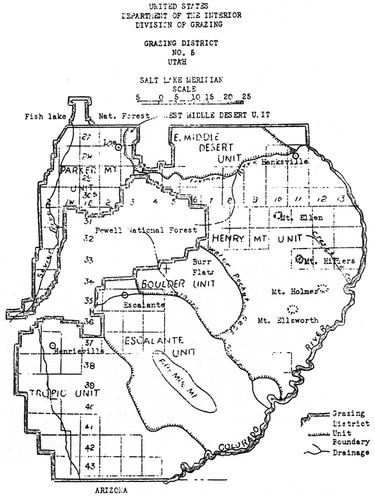
The area that includes Capitol Reef National Park was placed in Grazing District 5, officially established on May 7, 1935 (Fig. 34). [102] Each district had an advisory board, elected by its permittees, responsible for setting the original carrying capacities and the first line in settling disputes. The districts were then divided into allotments with one or several common users. Community and individual allotment committees were charged with setting up their own preliminary capacities and periods of use. [103] While it appears permits were issued almost immediately, they must not have carried much weight since permit priority was not clarified until January 1936 and the district offices were not established until a year after that. [104]
|
| Figure 34. Utah Grazing District #5. (click on image for an enlargement in a new window) |
At the January 1936 meeting in Salt Lake City, representatives from all the district advisory boards throughout the West gathered with the fledgling grazing service to decide on long-term regulations, the most important being the establishment of range fees and standards for grazing permits. Fees were initially set at five cents an Animal Unit Month (an adult and unweaned infant per month) for cattle and horses, and one cent an animal unit for sheep and goats (5 sheep = 1 AUM). [105]
Grazing permits, patterned after the forest service requirements, were to be issued according to a specific order of preference. First choice went to those with prior use (those with range claims for the previous five years) who had sufficient private or commensurate lands adjoining or close to the range in question. This decision was in line with the Taylor Grazing Act's original wording, and was also consistent with the traditional tenets of private property and prior use. Secondary permit priorities were for those with commensurate property but no prior use, followed by those with prior use but little or no property, and finally, everyone else. [106]
The link between property, prior use, grazing fees, and district advisory boards ensured that local, established users would carry the most weight in determining how the public domain would be used. The stabilization of the livestock industry, one of the primary motivations for the passage of the Taylor Grazing Act, was virtually guaranteed by this kind of system. It would be up to the U.S. Grazing Service and, after 1946, the Bureau of Land Management, to develop the other motivation: rehabilitation of the range.
At first, and some would say ever since, the federal officials charged with monitoring these new regulations were too few, and were too poorly funded to implement successful range conservation. Due to the lack of appropriations and manpower, the district graziers concentrated on means by which they could constructively cooperate with the local ranchers to gain their trust for the future.
The Federal Emergency Relief Administration (ERA) range improvement program was significant in showing ranchers that federal action could be positive. In its first year, the grazing service was given 60 Civilian Conservation Corps camps with approximately 12,000 workers to develop range improvements throughout the West. At that same October 1934 meeting with the ranchers and Director Carpenter, the Utah office of the ERA discussed potential improvement projects with the livestock operators. They determined that "work consisting of development of springs and seeps, construction of small reservoirs, drilling of wells, and the installation of tanks and troughs, would best serve the most pressing needs." [107]
Roads and stock driveways were also built with this unique federal assistance. With $200,000 of ERA money allocated to Utah one week later, advisory boards of ranchers met with the ERA engineers to determine what projects would benefit the most people. [108] In Garfield and Wayne Counties alone, 37 springs were improved for livestock use, four wells dug, four stock reservoirs built, and five trails either constructed or improved. While it is hard to determine if any of these range improvements is within Capitol Reef National Park, the names of these projects (which often reference local landmarks) suggest that at least a half dozen of these federal relief range improvement projects were completed within what is now the park boundary. [109]
Another early focus of federal management of the Waterpocket Fold country was eliminating some of the competition between sheep and cattle on the desert winter ranges. In 1935, competing Wayne County sheep owners and Garfield County cattle ranchers went to a U.S. Grazing Service hearings officer in Richfield to plead their cases. The sheep owners said they needed at least one month of winter grazing in the Circle Cliffs as part of their annual herding cycle. The cattle owners, who lived in the Boulder area close to the Circle Cliffs range, complained that the sheep grazing had destroyed their traditional, and now federally approved, range. During the course of testimony, Boulder rancher John King emphasized the adverse vegetation change resulting from this competition between cattle and sheep:
[All that's left is] a little shadscale, sagebrush, about all killed. No grass at all to amount to anything, only way on the ridge farthest away from water. But along the head of Horse Canyon or in the Flats there is some sagebrush there but it is pretty well killed. All the [Brigham] Tea is killed out there. Not much grass or browse. Spots of shadscale and sagebrush. [110]
The hearings officer concluded in favor the Boulder cattlemen, principally because they had prior use and could demonstrate closer commensurate property. Specific cattle and sheep allotment lines were drawn that effectively eliminated the Wayne County sheep herds from legally venturing onto the Circle Cliffs. Anne Snow observed that this curtailment of the range, coupled with cuts in the national forest sheep permits, drove some sheep owners out of business and caused others to switch over to cattle. [111]
Increased regulation, a lack of herders, and predators were the main reasons why sheep numbers steadily declined after the Taylor Grazing Act. The impacts of uncontrolled, year-long competition between sheep and cows throughout the late 19th century and into the 1930s is still evident on much of the grazed land along the Waterpocket Fold, including much of Capitol Reef National Park. Later attempts to rehabilitate the land by the Bureau of Land Management will be examined below.
Early Relationship Between Ranchers And Federal Land
Managers
As mentioned earlier, the beginning of the forest permit system had exposed some tensions between traditional users and new federal attempts to regulate resources. The Great Depression and war years of the 1930s and 1940s created further hardships, as well as determined resistance, from some ranchers opposing further U.S. Forest Service controls.
Livestock were being killed to keep them off the market in the early New Deal Days. Stockmen continued to hold their numbers up, hoping for better times. They fought reductions in number with all of their organizational ability. A group of stockmen at Escalante and another at St. George were especially strong in their opposition to further reduction in number....Forest officers knew what was happening but found opposition to change solidly entrenched against them. Meetings were continually held with stock associations, some lasting until 2 to 3 A. M. before either side would concede a point....There was extreme feeling between stockmen and Forest Service during this period and many reductions were forced through regardless of feelings. In most cases these reductions were even yet too small to solve the overgrazing problems and the ranges continued to decline....Many petitions were drawn up by the associations to get forest officers removed during the 1930s and 1940s. The Escalante livestock association petitioned against nearly every ranger they had over a period of 20 years. These efforts by stockmen though sometimes successful did not change the policy of the forest service to get the facts and proceed to instigate reductions on the basis of factual information. [112]
This kind of resistance to federal grazing policy was by no means universal. Many of the ranchers felt that both the forest service and grazing service regulations were needed, so long as their traditional rights and usage were respected. Golden Durfey, for instance, was mostly positive when asked his opinion of the Taylor Grazing Act and later BLM policies:
Well, we've got it and we've got to live with it and we do. And we have some people, some heads of it that are good and some that are bad. But it's better than it used to be. And then we're better too. We've learned to live with it. You know. They've learned to live with us and we've learned to live with them. [113]
Rancher Guy Pace concurred:
The Taylor Grazing Act was, I think, very necessary. What it did, it put people, it controlled where they were. Particularly sheep operators. See, those sheep used to go on the Henry Mountains and they just run wild. The people that owned the sheep was trying to feed the whole country in front of someone else. And the Taylor Grazing Act set up allotments [mostly for] cattle. And what they tried to do, is if you ran so many cattle in a certain area, that's where you stayed. [114]
Thus, by the middle to late 1930s, federal grazing regulations were in place on the remaining public domain. While there was certain resistance to federal regulation, especially when it meant herd reductions, the overall opinion was that the Taylor Grazing Act and U.S. Grazing Service policies stabilized the Western livestock industry. Whether it stopped damage to the fragile Western landscape is still being debated.
Ranchers and the federal grazing control agencies, each with different experiences and time-honored beliefs, attempted to find a middle ground in order to avoid conflict. Lack of money and understanding, rancher resistance, and the threat of congressional investigation prevented the federal agencies from instituting range controls as soon as they would have liked. On the other hand, cultural, religious, and traditional ranching values were difficult for the southern Utah livestock operator to put aside.
During the 1930s, the unquestioned belief, the paradigm, was that public domain throughout the American West was to be used for grazing, mining, or timber. Public lands, therefore, were placed under the control of these interests, provided they followed the specified controlling federal land managers' policies. The practice of setting these lands aside for recreation was still decades away.
In the meantime, there was a growing feeling among local tourism boosters that at least some of the canyon country of southern Utah should be brought into the national park system. The prospect of another, even stricter, federal agency entering the land control arena was more than some ranchers were willing to accept. If the relationship between the USFS or BLM and the ranchers was tense, imagine the reactions toward a new federal agency whose mission included the elimination of grazing from traditional grazing lands.
Grazing During The Early Years Of Capitol Reef
National Monument
General National Park Service Policy: 1916 To 1934
While it is often assumed that grazing is not allowed in national parks and monuments, this is not the case. According to the 1916 National Park Service Origins Act,
the Secretary of the Interior may, under such rules and regulations and on such terms as he may prescribe, grant the privilege to graze live stock within any national park, monument, or reservation herein referred to when in his judgment such use is not detrimental to the primary purpose for which such park, monument, or reservation was created. [115]
Because of this clause in the enabling legislation of the National Park Service, and because of traditional grazing in areas later added to the national park system, many of the older Western parks and monuments continued to allow grazing. Some parks gradually phased out grazing, while others actually increased livestock usage, particularly during the livestock range expansion of World War I. [116] For example, to the question of whether grazing would be allowed in an expanded Sequoia National Park in 1918, Acting National Park Service Director Alexander Volgelsang responded:
We are unable to see how the transfer of any of the lands covered by these measures from the forest service to the National Park Service will in any way affect the grazing problem, as there never has been any thought of prohibiting the utilization of the grazing areas in this region during the existing emergency or even after the war is over. [117]
By the 1930s, however, the growth of the national park system into previously grazed areas created increasing conflicts with ranchers. In southern Utah, this was clearly evident with the ranchers' resistance to the National Park Service proposal to include a large part of the Colorado Plateau in an Escalante National Monument. As a direct result of these negative reactions by livestock interests, when Capitol Reef National Monument was created on August 2, 1937, the boundaries were consciously created to eliminate as many grazing permits and as much grazing potential as possible. [118]
Establishing A Grazing Policy At Capitol Reef National Monument
After Capitol Reef National Monument was established, National Park Service officials would find themselves forced to deal with periodic grazing concerns, even though it was believed that "gradual, even immediate, elimination of this range stock should not present a critical problem." [119] While the number of livestock and acreage of area grazed were relatively small, the economic dependence and traditional lifestyles of the isolated local communities, as well as previous and perpetual impacts on the natural ecosystems, dictated that grazing would forever be a concern for managers of Capitol Reef.
From the outset, even the presidential proclamation that established this small, 37,000-acre monument in the northern, spectacular section of the Waterpocket Fold specifically addressed the movement of cattle across monument lands. It states, "Nothing herein shall prevent the movement of livestock across the lands included in this monument under such regulations as may be prescribed by the Secretary of the Interior and upon the driveways to be specially designated by said Secretary." [120]
This wording was inserted into the proclamation "to meet the needs of local stock growers in the movement of livestock." According to Acting Secretary of Interior Charles West, this phrasing was needed to protect ranching interests, as he had already signed departmental orders excluding the land within the monument boundaries from Grazing District 5 and revoking the grazing service's stock driveway withdrawal, which covered 3,480 acres now within the national monument. [121]
The lack of an on-site custodian at Capitol Reef until 1944, however, and the National Park Service's emphasis on development of roads and the Fruita headquarters area would significantly control grazing within the new monument. The rugged canyon labyrinths, physical isolation, private lands, lack of fencing, and a slowly evolving grazing service staff certainly did not help. In the face of these limitations, National Park Service officials tended to respond to grazing conflicts with policies that were neither enforceable nor even made known to the livestock owners.
From the beginning, grazing was never adequately addressed. Only a week after the presidential proclamation, Zion National Park Superintendent Preston Patraw, who was given jurisdiction over Capitol Reef, wrote Regional Director Frank Kittredge concerning "the more important projects" at the new monument. Patraw saw establishment of stock driveways and control of trespass grazing as priorities. Of the seven projects listed, stock driveways were number one. Patraw wrote, "All the various drainage canyons cutting through the Waterpocket Fold are used as driveways. Under agreement executed with stockmen, this may be limited to one driveway when properly developed. Development of a stock driveway will protect the other canyons." [122]
Patraw also believed that "grazing may be eliminated immediately over much of the monument if exclusion fences on the boundary and drift fences can be constructed now....For adequate protection of monument lands from grazing and other unauthorized operations...a permanent ranger resident in the monument is needed, and of course a ranger station is required." [123]
Thus, it appeared that grazing issues would be addressed from the beginning. In Regional Director Kittredge's response, however, grazing was completely ignored in favor of issues that had a greater consensus: long range planning and development of roads and other public accommodations. [124] The regional director put grazing policy on the back burner. In fact, all of Capitol Reef National Monument was given low priority: it did not even receive a volunteer custodian until 1944, and was not officially "activated" and given a separate, yearly budget until 1950. [125]
Two years later came what appears to be the first attempt to get specific information on grazing within the monument. Zion National Park Assistant Superintendent John M. Davis contacted Rulen Meeks, a prominent local rancher from Bicknell and member of the local grazing advisory board. According to Davis, Meeks told him that there were seven permittees with approximately 215 head of cattle, 300 sheep, and 20 horses, which grazed lands "not confined entirely in the Monument but include land outside as well." [126]
Although the information, as detailed by Davis, is not specific to allotment, it appears that Will, Dez, and Joe Hickman's 85 cattle had the southern half of the Meeks Mesa Allotment. James Pace's 300 sheep and Walter Smith's 35 cattle were assigned either to the Meeks Mesa or Torrey Town Allotment, and Clarence Mulford's 60 cattle and 20 horses were in the Fruita Allotment, which included his own private lands. In addition, George Clark held a permit to graze 35 cattle throughout the winter in Capitol Gorge, within monument boundaries. [127]
Davis also mentioned the traditional stock driveways used in the monument:
Grand Wash is used as a stock driveway only by the Meeks brothers. Capitol Wash and Pleasant Creek are generally used by all livestock owners. Pleasant Creek is used the most because of the pressure of poisonous weeds in Capitol Wash.... Stock using driveways through the Monument are supposed to make at least five miles a day. [128]
As part of the same study, Davis wrote a memorandum to his superintendent on May 1, 1939, detailing the lack of information pertaining to grazing within the monument:
The Capitol Reef [file] has been searched and nothing can be found on the minutes of any meeting where grazing was discussed or decided upon. These files were also searched for instructions from our Washington Office on the handling of grazing in the Monument. In all correspondence there is very little said about grazing and apparently this problem was not given much consideration or considered an important factor in the establishment of the monument. [129]
Even though Davis did not find anything in the Zion files, a thorough examination of the investigations and correspondence relating to a potential Capitol Reef National Monument makes it clear that opposition from grazing interests actually played a significant role in the eventual size and status of the area. [130] This opposition, or the threat of it, may have been one reason why so little had been done about the issue since it had first been raised by Patraw two years earlier. Even with this admitted lack of information about grazing within Capitol Reef, Assistant Superintendent Davis was willing to predict that all grazing could be phased out "with very little opposition" and that the number of stock driveways could be reduced to one "without much inconvenience to stock owners." [131]
Davis's conclusions were reached without taking into account the need for expensive fencing to enforce a grazing phaseout, the large amount of private land on which stock was free to roam, and the extra time and adverse impact on resources or ranchers. This failure to recognize existing conditions and local attitudes when determining grazing policy would plague Capitol Reef managers for many years to come.
The Scientists Arrive
A chance to gain more information came with the visits of the first scientific surveys of the new monument in the fall of 1939 and the spring of 1940. National Park Service Field Naturalist Joseph Dixon was the first to visit the area in October 1939. His "Special Report on Geology, Flora and Fauna" deals little with the natural resources, concentrating more on the Civilian Conservation Corps-constructed trail up to Hickman Natural Bridge just outside Fruita. His listing of flora and fauna are cursory at best, and he never mentions any part of the monument outside of Fruita and the Fremont River canyon. Nor does he mention any plant life other than trees. In his recommendations, Dixon urges further study of the cultural and natural resources, but never mentions grazing or its impacts. In short, his report is of little value in assessing the state of natural resources at Capitol Reef. [132]
The following May, Regional Biologist W. B. McDougall spent two days in the monument assessing its vegetative cover. Unfortunately, only the first day was spent in observation, and even then only along the road corridor. The next day it started raining, so he thought it best to leave while the road was still passable. During this all too brief visit, McDougall attempted to itemize the typical vegetation and the impacts of grazing. [133]
According to the biologist, the vegetation consisted of widely spaced pinyon and juniper trees with scattered serviceberry, cliff rose, Mormon tea, squaw bush, silver buffaloberry, "and in some places, where it has not been eaten by cattle or sheep,....some grass." McDougall further observed:
Cattle overrun the Monument everywhere to the number of about 200 head or more. So far as I know, no permits are issued but it wouldn't make any difference anyway under present conditions because there is no resident custodian to look after the area. If all domestic animals could be removed from the area, it probably would support a herd of 200 or more deer....[T]his area represents a certain biological type and it is hoped that the time will come when it can be administered in such a way as to represent this type normally. Primarily, of course, it is a geological monument but it is large enough to be biologically significant if it could be properly protected. [134]
McDougall's account of the overgrazing at first seems like overwhelming evidence of the damage livestock was having on the entire monument. Unfortunately, McDougall hiked only near the road, which was one of the traditional stock driveways through the area and, thus, the most severely impacted area of the monument. May is also the month when the cows and their calves are waiting to be moved to the mountains for the summer. Therefore, McDougall's findings are neither complete nor valid.
Capitol Reefs Grazing Policy Takes Shape
As part of an overall review of grazing in the National Park Service in 1941, Zion Superintendent Paul Franke was asked to contribute information on Capitol Reef National Monument, since there was no mention of it in the Washington files. [135] Franke's response generated the first known grazing policy for Capitol Reef National Monument.
Franke first determined from District Grazier D. S. Moffitt in Richfield, Utah that (except for stock driveway use) no permits had been issued for any lands within the monument for the past year. However, he reported, "No doubt there is some unauthorized grazing by local stockmen and residents of the village of Fruita. Such grazing can not be brought under control until the monument boundary is fenced and protection personnel provided to enforce regulations in this area." [136]
Concerning the stock driveways, Franke's search of the files showed that no one canyon had yet been specified for such use. However, he wrote, "As soon as time permits a study of this use will be made and recommendations submitted for consideration in the designation of driveways by the Secretary of the Interior." Apparently, this study was never completed, as driveways were never specifically designated by the secretary. This meant that the traditional trails would be used as before. [137]
In the accompanying charts and grazing policy statements, the specific grazing impacts on monument lands were detailed. It was estimated that the stock driveways saw up to 1,000 head of cattle for about four days a year. Within the monument there were also 115 cattle and 30 horses that grazed 918 acres of private land, and 200 cattle on 2,474 acres of state or county land from two to three months a year. The amount of land "overgrazed by trespass stock due to lack offence and other controls" was estimated at 300 cattle over 6,760 acres of land for the three winter months. The remaining 24,542 acres, or 67 percent of monument lands, were considered too barren or inaccessible to grazing. The carrying capacity was determined to be 255 cows per month for the entire monument, or 40 acres per cow. [138]
The grazing policy statement, presumably written in 1941, ruled out the grazing of additional livestock on monument lands. This was justified by the already overgrazed condition of some park areas, and the lack of personnel to monitor livestock. The statement declared, "The Monument being already in a badly overgrazed condition, the placing of more livestock in the area cannot fail to seriously aggravate the existing undesirable conditions and would promote erosion of a damaging nature." [139]
The policy statement also established that "stock grazed in Capitol Reef are legally on trespass as no permits have been issued to graze." [140]
While this policy statement makes it clear that grazing was not permitted within monument boundaries except through the limited use of stock driveways, the lack of enforcement meant that some ranchers would continue to use their traditional winter grazing areas.
Grazing Issues And Conflicts At Capitol Reef:
1948-1957
In August 1948, 11 years after the monument's creation, Capitol Reef Custodian Charles Kelly discovered a well-used, recent cattle trail to the rocky mesas between Grand Wash and Capitol Gorge. Kelly inquired among the local ranchers as to whose cows were in the monument, and learned that George Clark of Torrey held a grazing permit for the area. [141] This is, presumably, the same George Clark who had a winter permit for 35 cows for the Capitol Gorge area in 1939.
Zion Superintendent Charles Smith wrote a letter directly to Clark informing him that grazing was not legal in the national monument and requesting that he get his permit revised by the Bureau of Land Management. [142] Since there is no record of correspondence between Smith or Kelly and the BLM on this matter, it is hard to determine why Clark was able to continue grazing within the monument for so long. Presumably, either Clark continued using his traditional winter range within the national monument without knowledge of or care about its no-grazing policy, or he had a 10-year permit for the area that was only then coming due.
While George Clark soon removed his cattle without complaint, this action stimulated the concerns of other local ranchers as to how they would be compensated for their grazing privileges in the Meeks Mesa, Torrey Town, or Fruita Allotments lands within the monument. Charles Kelly wrote:
They think that if they are excluded from the monument, the grazing service should give them some other grazing area; or if that can't be done, the park service should compensate them for the loss of their rights. To date they have made annual payments for these rights. The fact is they did not know just where the boundaries were, and believed they were on public domain....Actually, the cattle who wander into the monument do no particular damage, since there is almost no vegetation in that section. However, if this place is ever fenced, the matter will have to be adjusted. The cattlemen have believed they were within their rights, and I did not know until this week that they had grazing rights within the monument boundaries. [143]
This notice from Kelly elicited a detailed response from Superintendent Smith. Smith reiterated the old assumption that the range within Capitol Reef National Monument was of such little value that it had previously been considered unimportant. [144]
Smith went on to clarify National Park Service policy toward the use of stock driveways, the ranchers' permits, and the manner in which future trespass should be handled. According to Smith, several visits of national park officials in the late 1930s and consultations with the local grazing board had determined that the monument would allow livestock drives over the Fremont, Grand Wash, Capitol Wash, and Pleasant Creek gorges. The drives were to be expeditious and were not to take more than one day through the monument. [145]
As to the ranchers' belief that their permits covered lands within the monument, Smith recited the 1941 statement by the district grazier that no permits had been issued for the monument; thus, "[t]his makes it very definite that there are no grazing rights on government lands within the area." [146] One fact Superintendent Smith failed to mention was that just prior to the presidential proclamation back in August 1937, the secretary had ordered all monument lands excluded from the grazing district. Thus, even if the U.S. Grazing Service, and later BLM, had issued permits, they should have been no longer valid. Smith also advised Kelly to tell the individual livestock owners that it was their responsibility to get permits adjusted, although the National Park Service would assist with clarifications. There is also no mention of compensation in those cases where the number of permitted livestock was reduced.
Smith realized, though, that with a total lack of fencing and boundary markers, a certain amount of trespass grazing was not only inevitable, but tolerable. He wrote:
We have no doubt that trespass grazing is quite common, unintentional or otherwise. We are not going to shut our eyes to flagrant trespass nor are we going to demand that the livestock men ride daily herd on their stock. We expect them to be reasonable and to show some respect for the regulations. If they do this, and do not take advantage of our attitude we will tolerate minor trespass....When physical improvements are made and other development take place the stock will be excluded entirely and the owner will have to see that they do keep out. Any tolerance we display now cannot be used as a basis for assuming that a privilege exists. [147]
In other words, while grazing was not permitted within the monument, there was little the National Park Service could do at that time to prevent all but the most flagrant cases of trespass. Thus, by the end of Capitol Reef's first decade, there was a semblance of a grazing policy, but it was vague and still unenforceable. As long as this was the case, the local ranchers would continue to graze their traditional ranges.
Toward the end of 1950, soil and conservation officials arrived to assess the potential for a comprehensive plan for Capitol Reef. As part of the initial soil survey, the impacts of grazing were noticed, as was the fact that severe drought had caused winter grazing in the immediate area to be curtailed for the last several years. It was anticipated, however, that livestock would soon be returned to area. Soil conservationists warned that if stock were allowed to continue trespass and unmonitored use during stock drives, there would be little point in beginning an extensive erosion control program. [148] The soil conservationist also mentioned that the grass types found in the monument included the dominant galleta, with lesser amounts of alkali sacaton, blue gamma, sand dropseed, and salt grass. It is not known exactly where these grasses were found or how extensive was the survey. [149]
By the mid-1950s, it seems that grazing conflicts at Capitol Reef National Monument had worked themselves out. So long as the ranchers were willing to control stock trespass as best they could, nothing was said by the Capitol Reef's new superintendent, Charles Kelly. In the 1953 Capitol Reef National Monument Master Plan, Kelly mentioned continued trespass problems, but expressed more frustration with the manner in which cattle were driven through the monument. He complained, "The monument is unfenced, and stray stock drift into it occasionally. However, the vegetation is so sparse that little damage results. Unfortunately, there is no designated stock driveway, and herds of cattle pass through without supervision, usually bedding two nights on the monument." [150]
One year later, however, Charles Kelly lost his patience with wandering stock. The incident apparently began when one of the private landowners inside the monument, Cass Mulford, refused to keep his cows and horses from crossing onto the monument. Kelly was particularly irate because the cows were grazing in the campground, at that time located on Sulphur Creek north of the present visitor center. According to Kelly, two other ranchers decided that if Mulford could get away with trespass, they might as well let their cows onto the monument lands, too. Kelly notified the regional office in Santa Fe of the problem and recommended that his superiors send him a "rather strong order" to remove the cows. But the superintendent also warned this may not work, and desired to know what other course of action he should take. Kelly also consulted the Richfield office of the Bureau of Land Management to see how they handled livestock trespass cases. [151]
This memorandum sparked a flurry of correspondence between Kelly and the regional office over how to handle grazing trespass. The regional office requested more information, researched applicable fence and impoundment laws, and asked Kelly to write down as many specific details as possible. Kelly was told that, if necessary, the sheriff should be called in to impound the offending animals. Assistant Regional Director Hugh Miller also warned Kelly to proceed cautiously, since this would be "bad public relations if it is necessary to go the whole way." He asked, "Is the total damage, plus nuisance, worth it?" [152]
Kelly responded that the sheriff, being one of the local Mormons, would probably not cooperate, and "[t]he county attorney would do so only reluctantly." Superintendent Kelly's solution was to build a drift fence across Sulphur Creek just west of the ranger station to prevent more strays entering the campground. He also suggested that the regional office issue Kelly an order to keep the monument free of cattle.
"I can then show this order to the offenders," Kelly wrote, "and it will have more weight than if I issued it here. They will not be so apt to hold it against me personally when the rule is enforced." [153]
As for public opinion, he complained:
I realize that the natives here will not be happy, but they have ceased to cooperate and after ten years it is time to let them know that this is actually a national monument. We also have to consider relations with the traveling public. Last summer a locoed cow walked through the tent of a camper in the night, and the resulting publicity was certainly not complimentary to the park service. When campers are kept awake all night by prowling stock, and their camps are messed with fresh manure, they ask me whether Capitol Reef is a national monument or merely a cow pasture. [154]
Eventually, the requested order from Regional Director Minor R. Tillotson arrived. Kelly then notified all local livestock owners that he had been directed to do whatever it took to keep stock off the monument. If trespass continued, Kelly warned, he would "be forced to resort to legal procedures to correct the situation." [155]
Kelly also informed the ranchers that no trailing or bedding of livestock would be permitted in the campground area, and that Utah Highway 24 would continue to serve as the designated stock driveway. There is no documentation available that elaborates on exactly when this decision had been made, or by whom. This is especially puzzling since only a year before, in the 1953 master plan, Kelly stated that there was no one designated stock driveway through the monument. [156]
This order seems to have satisfied both the ranchers in question and Superintendent Kelly for the time, as there is no more reference to the matter. After this episode, grazing once again resumed its place on the back burner, only to flare up again in 1957.
Kelly's nearest neighbors, Merin and Cora Smith, had a few cows that would apparently wander onto National Monument property from time to time. In June 1957, Kelly discovered that these cows had eaten much of his flower garden and "ruined" his vegetable garden and younger fruit trees. According to Kelly, he confronted Merin Smith and told him that he "would not any longer stand his pasturing his cattle in [Kelly's] yard." Smith, recorded Kelly, responded irately that his cows were there long before Kelly and that "he ha[d] always pastured his cattle on the government property (true) and still intend[ed] to do so" [parenthetical notes are Kelly's]. The Smiths then told the superintendent to remove the National Park Service picnic tables from around the Fruita schoolhouse, which was on their property. [157]
Charles Kelly may not have been the best man to handle an issue as sensitive as livestock trespass on National Park Service lands. Nevertheless, these examples do point out that if grazing policy is not clear, well known, and enforceable, then there is significant potential for conflict.
Nevertheless, the tiny monument's grazing problems paled in comparison to those of other national parks and monuments. Excluding eastern parks where livestock pasturage occurred and the more multiple-use-oriented national recreation areas, the 1957 totals for grazing within the national park system included 112 permittees. These permittees had approximately 10,000 head of cattle, 860 horses, and 15,000 sheep and goats. These accounted for 88,591 AUMs permitted on National Park Service lands. The largest AUMs were concentrated in Utah's Dinosaur National Monument, with 17,000 (mostly sheep); Grand Teton National Park, with 11,600 (cattle); Grand Canyon National Monument, with 15,000 (Navajo sheep); and Organ Pipe National Monument, with 13,000 (cattle). [158]
At Capitol Reef National Monument, grazing concerns lessened as Mission 66 development money was used to fence portions of the monument boundary, and special use permits were issued to regulate the monument's stock driveways. [159]
While Capitol Reef's grazing problems appear relatively minor throughout the first three decades of monument's history, this would suddenly change when another presidential proclamation in 1969 increased its size by 600 percent. This new monument land consisted of public domain within and surrounding the rest of the magnificent Waterpocket Fold, principally used for winter grazing range. Before discussing the implications this expansion, it is important to touch briefly on USFS and BLM range management of the public domain that would soon be added to the national park system.
Grazing On Public Lands Later Added To Capitol
Reef: 1950 To 1969
The uneasy relationship among the federal land management agencies and south-central Utah ranchers continued throughout the 1940s, '50s, and '60s. During this time, more scientific range surveys were completed for much of the land, and carrying capacities were established. Virtually every one of the new agency limits was less than the old limits set when ranchers had determined the carrying capacity in the 1930s. This required the Bureau of Land Management and the U.S. Forest Service to request reductions, which were often fought by the traditional users of the land. Through the advisory boards and the hearing process, the ranchers' grievances were heard, and sometimes compromises were made. Throughout the process, however, the range continued to be utilized at its highest limits. [160]
Range improvement programs provided one avenue of cooperation between federal land management agencies and the area ranchers. The BLM and USFS used a portion of each year's grazing fees to help ranchers build or improve stock ponds, trails, and fencing, and to reseed some of the more damaged ranges.
Summer Range: The National Forest Lands
By 1950, the Dixie National Forest, which included the Boulder Mountain area directly west and southwest of Capitol Reef National Monument, had been regulating grazing through permits and advisory boards for well over 40 years. While some gains had been made in terms of the range and federal-local cooperation, a history of the national forest indicates that there was still a long way to go:
Reseeding areas though greatly inadequate had tended to relieve pressures in some areas. Transfer reductions, exchanges, association purchases with cancellations and outright reductions had gone a long way toward easing the pressures and improving the relationships of stockmen and Forest Service on the Dixie ranges....The national [sic] Cattle Association had adopted a policy of cooperation. The National Woolgrowers, however, were still fighting for range rights instead of privileges along with other special considerations...1956 found the Dixie in a strong position to hold the gains that had been made and with emphasis on watershed, wildlife, recreation, reseeding, and farm pasture[,] further inroads into livestock numbers on overgrazed ranges may be effected. [161]
These livestock reductions occurred over many years. Ultimately, cattle, horse, and sheep grazing on the East Slope Allotment on Boulder Mountain was reduced from a total of 30,425 AUMs in 1920 to only 12,223 AUMs in 1959. The period of use had also been reduced. Cattle and sheep were now kept off the allotment until either May or June 1, whereas the 1920 permits allowed stock to graze as early as the middle of March. [162]
By 1959, forest service officials determined that the range was still "overstocked and the range to be in a depleted condition." A year later, an agreement was signed by the permittees on the east slope of Boulder Mountain to reduce their stock by another 35 percent over the next two years. By 1965 the last of the sheep permits had been converted to cattle, meaning even less competition. While some of the stock were later allowed back onto the range by the mid-1970s, these significant reduction numbers prove that the U.S. Forest Service was gaining control over range depletion. [163]
The method of grazing, however, had not changed since the turn of the century. Livestock were traditionally turned loose in the spring to "let them follow grass greenup to the Top, then be pushed off by fall or winter storms." Attempts by forest officials to establish a more regulated pattern were hampered by rough terrain and lack of fencing. Thus, while the number of livestock on Boulder Mountain had been significantly reduced by the end of the 1960s, the cattle were still allowed to roam the ranges far more freely than the U.S. Forest Service would have preferred. [164]
To the northwest of Capitol Reef National Monument, the large expanse of Thousand Lake Mountain is largely within the boundaries of Fishlake National Forest. The Sulphur Cattle and Horse Allotment bordered the monument from 1937 to 1969. This allotment included portions of Meeks Mesa, Spring Canyon, and Paradise Flats, which were later added to the monument through expansion in 1969. The eastern portion of the Polk Creek Allotment was included within the final national park boundaries in 1971. [165]
Throughout the 1940s and 1950s, there were consistent attempts by forest rangers to control livestock numbers and seasonal use on these allotments, especially during drought years. Unfortunately, there is no detailed grazing history available for this area. Yet, the number of U.S. Forest Service requests for reductions in livestock numbers or days of use, as well as some of the statements made at the advisory board meetings, indicates that Fishlake National Forest officials were just as active as their counterparts in the Dixie National Forest. [166]
Year-Round Range: The Baker Ranch
In the south end of the Waterpocket Fold, under the present high-water mark of Lake Powell, a cattle ranch established at the turn of the century impacted livestock operations in the area until the mid-1980s. Eight hundred Desert Homestead acres were first deeded to Thomas Smith, his wife, and their daughter-in-law sometime around 1910, and then were sold to Eugene Baker and sons in 1919. The Bakers doubled the base ranch and built all the out-buildings necessary to run a year-round, virtually self-sufficient ranch. After all, the Baker Ranch was located 80 miles by horse trail from Escalante, the closest real community from which goods could be purchased. It had an orchard and grape vines, and diverted water to cultivate 60-80 acres of alfalfa and corn. Most importantly, the Bakers ran 800 to 1,000 cattle and about 40 horses on a range "bordered in a rough triangle by the Henry Mountains on the north, the Colorado River on the east, and Waterpocket Fold on the south and west." This area is estimated to be about 25x35x40 miles. [167]
During the 1920s, cattle were grazed year-round on this open, public domain. [168] After the Taylor Grazing Act passed, however, the Baker herds were dramatically reduced to conform more closely to the established carrying capacity of the range. For example, in 1935 the Bakers grazed about 1,200 cattle and 75 horses on the unrestricted range. By 1938, the permitted number of livestock had been reduced to the carrying capacity of the range, only 440 cattle as determined by the district grazier. These were to run on an allotment that was the Halls Creek drainage from its mouth at the Colorado River up to Muley Twist Canyon. Apparently, there was no seasonal restriction at this time. [169]
Though the Bakers protested this reduction through the hearing process, the district grazier's decision was upheld. Even though the Bakers claimed that they could not make a living with such a reduced herd, the ranch continued its operations until the mid-1940s. At that time, Eugene's son, Carlyle, purchased a ranch on the eastern slope of Thousand Lake Mountain. By 1946, the Baker Ranch, and thus the rights to its allotment, had been sold to 10 ranchers from Wayne County, Utah. These men formed the Halls Creek Cattle Association, cooperatively using the Baker property until it was purchased by the federal government for Lake Powell in 1963. Ten years earlier, the Halls Creek Cattle Association transferred its grazing privileges in lower Halls Creek northward to "more productive holdings in Wayne County." [170]
Pre-1969 grazing management records for the other areas fringing the expanded boundary of Capitol Reef pertain mostly to yearly permits. There are also a few range studies, allotment plans, and protest hearings. [171] These records suggest that the BLM (created from the consolidation of the U.S. Grazing Service and the General Land Office in 1946) sought the cooperation of established ranchers in reducing livestock numbers and regulating use. In many cases, however, the range was in such a weak condition that the BLM changes reduced, but by no means eliminated, damage to the fragile desert vegetation.
Winter Range I: Bureau Of Land Management In The South
District
South of the Fremont River, along the eastern slopes of the Waterpocket Fold, is an area of traditional winter grazing known as the Sandy Allotments. This region, which includes the private ranches at Notom and Sandy Ranch (previously the Bowns Ranch), had been heavily grazed by cattle and huge herds of sheep since the late 1800s.
During 1962 and 1963, a comprehensive range survey was completed for the entire West Henry Mountain Range, which extends from the Fremont River to the Colorado River and from the Waterpocket Fold to the west slope of the Henry Mountains. Approximately the western one-third of this range was included in the 1971 Capitol Reef National Park boundary. Detailed vegetation, soil, and climate descriptions were made and final carrying capacities were established. [172]
During the early 1960s, there were 34 cattle operators with a total of 33,196 potential AUMs, and seven sheep operators with a total demand of 20,197 AUMs. These AUMs permitted grazing of 14,000 sheep and 2,000 cattle over seven and a half months in the area south of The Post (one mile south of the junction of the Burr Trail and Notom Bullfrog Road). They also allowed grazing of 4,000 sheep for seven months, 2,930 cattle during the winter, and 864 cattle during the summer. [173] The only summer usage along the Waterpocket Fold was by the Sandy Ranch, then operated by John Christensen.
The current condition of the entire range was established as .8 percent good, 43 percent fair, 39 percent poor, 10 percent bad, and 7 percent wasteland. The range conservationist noted:
The trend for most of the Unit is static with some areas declining. One of the areas which declined quite rapidly is Hall Creek in the Baker Allotment. This area is badly depleted and shows signs of very heavy use. Another of the poorer areas is the flats south of Sandy Ranch. Here most all perennial plants are gone with the exception of greasewood. The predominate forage here is Russian thistle. [174]
A dramatic increase in erosion, described as "very active and in advanced stages," was also noticed for the southern portion of what later became part of Capitol Reef National Park. Erosion was considered especially significant in the areas of Bitter Creek Divide, Sandy Ranch, the head of Muley Twist Canyon along the Halls Creek drainage, and east of The Post. The range study reported, "The erosion in most of these areas is advancing quite rapidly due to depleted forage conditions and lack of erosion control structures. The erosion in many of the above areas makes travel difficult." [175]
Much of the range was considered to be in such a fragile state that only a few extra livestock or a slight change in periods of use would be a noticeable detriment to the range. For example, one of the pastures used for study was in the vicinity of Bitter Creek Divide, along the eastern side of the Waterpocket Fold and about six miles north of the Burr Trail/ Notom-Bullfrog Road junction. For the 950 acres used in that pasture, it was determined that there were only 56 AUMs of feed available in 1962. The actual use that year was 58 AUMs. The next year there were 52 cattle in the pasture for one month, for a total of 52 AUMs, but there were also 50 cows that trespassed on this range for 10 days. This extra utilization was easily noticed by the survey crew, which recommended that this particular range be maintained at 58 AUMs. [176]
Because of the depleted condition of the range, it was recommended that the number of livestock and the seasons of use be reduced. This involved eliminating all summer ranges and establishing firm opening and closing dates, which would allow the vegetation to grow, flower, and seed. Identifying livestock distribution as a big problem, the study called for a large number of additional water development projects, salting, and fencing. Because the vegetation types were suitable for both sheep and cattle, and because the area's rugged topography made it difficult to fence out either species, the study concluded that the unit should be used by both classes of livestock. This could be done, the study suggested, by designating common use allotments or by setting up pastures and alternating livestock use. [177]
In 1964, the Bureau of Land Management, in accordance with the range survey's recommendations, decided to reduce livestock by as much as 74 percent in the Sandy Allotments. Some ranchers fought this reduction by claiming as much allotment land as possible, thereby pitting neighbor against neighbor. In a September meeting with BLM District Manager R. L. Caudill, the Durfeys of Notom claimed that they were not being given proper credit for land that they had always grazed. Caudill reported that Golden Durfey was so irate about the extreme reduction in his range that he vowed to have "this area as his allotment if it is the last thing that he was able to do." [178]
Two days later, District Manager Caudill met with the Morrell brothers, who shared the upper Sandy Allotment with the Durfeys. Clearly, the Morrells and the Durfeys believed they were the victims of the larger Christensen and Don E. Taylor herds. Caudill reported:
Both the Morrells indicated their displeasure at the severity of the indicated adjustment. They criticized the Bureau for 'favoritism' to Don Taylor and the Christensen Ranches. They expressed [the] opinion that the present range condition was directly [attributable] to us allowing the Christensen Ranches to graze the area during the summer months. They further indicated that the condition was [attributable] to trespass use by Don Taylor. They indicated agreement in the discussion that the range condition was less than fair condition but stated that they were being unfairly penalized for over use and abuse of the range by the other livestock operators. [179]
Despite these protests, in January 1965 District Manager Caudill called for a 74.2 percent reduction throughout the Sandy Allotment. He explained:
I fully realize that a reduction in grazing privileges will impose a hardship upon [certain ranchers]. However, the range in the Sandy Area is predominately in a poor to fair condition. Adjustments are essential for this range, with improvement, to reach its potential grazing capacity and a good range condition. A reduction of grazing privileges in the Sandy Area is necessary to reach the grazing capacity of the Federal range. [180]
Recognizing the hardships imposed, the district manager approved the district advisory board's suggestion of a three-year phaseout. Caudill did give the ranchers some hope, however. He promised, "Range conditions and utilization studies of the Federal range will be made each year. Should these studies show an improved range condition and increases in grazing capacity, an adjustment in the third year reduction will be made." [181]
This decision also established a firm maximum period of use as between October 1 and April 15 each year. This was done over the objections from many of the ranchers, the manager wrote, because "closing the range for grazing, during the initial and critical growth period for the forage plants in the spring, will improve the condition of the range. Protection from grazing during the summer months will allow maximum forage protection and provide natural reseeding of the range." [182]
The district manager, again in consultation with the advisory board, also stipulated that the Sandy area would be separated into three allotments. The Morrells and Durfeys would have their own northern allotment, Sandy #1, around Notom; the Christensen-owned Sandy Ranches would have exclusive use of Sandy #2, which stretched along the eastern side of the Waterpocket Fold; and Sandy #3, from Cedar Mesa to The Post, would be licensed to Don E. and Afton Taylor, C. A. Clark, and Urban Hanks. It was about this time that the Waterpocket Fold Allotment along Halls Creek was also created and use permits issued to Don Taylor (Fig. 35). These partitions were most likely made to help resolve the disputes among the various permittees and make the reductions more enforceable. [183]
Just two years later, bureau officials and some of the permittees conducting a field tour found that the range in all areas had improved. This improvement was impressive enough to justify significantly revising the 1965 timetable. [184]
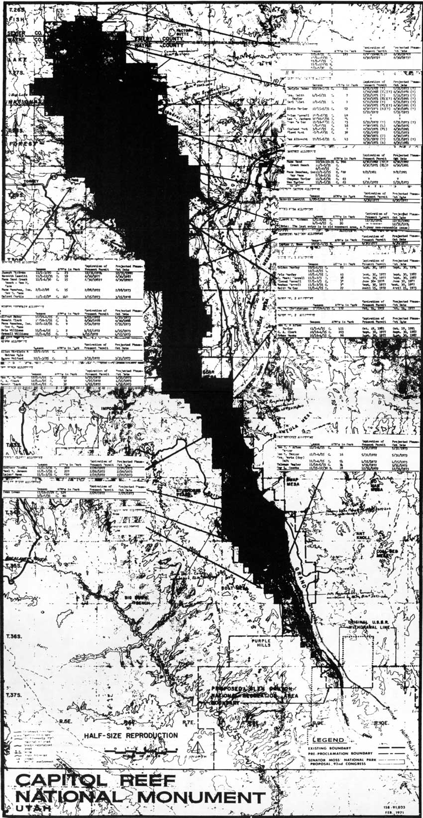
|
| Figure 35. Grazing permits, allotments, and phaseout dates, 1969. (click on image for an enlargement in a new window) |
Winter Range II: Bureau Of Land Management In The North
District
Similar difficulties arose in the northern section of what would later be Capitol Reef National Monument: the traditionally grazed areas known as the Cathedral Valley, Middle Desert, Hartnet, and South Desert. An allotment plan for the Hartnet Mesa in 1966 stated:
Prior to passage of the Taylor Grazing Act in 1934, large numbers of livestock were brought from Wayne, Sevier, and Emery Counties to winter these lands. Many of the animals remained on the range year-long, resulting in progressive destruction of soils and vegetation. Reports from stockmen in the area indicate that many trespass horses used the area until about 1955. Prior to 1946 there were at least 163 cattle and 20 horses licensed yearlong in this area. [185]
By 1953, range conditions had not improved. This sparked a dispute between William G. Taylor and Guy Pace as to who had priority use for the South Desert. The year before, the BLM range manager denied Taylor's application, explaining that there was "insufficient forage in the South Desert to take care of these 30 cattle along with qualified use already established in the South Desert." [186]
Other evidence and testimony during this appeal established that the permitted use of the South Desert and Middle Desert exceeded established carrying capacity. It was noted that Guy Pace, the primary user of the South Desert, had been forced in 1953 to move his livestock out of the South Desert early because there was not sufficient feed for them. The range manager decided that William Taylor would graze his cattle in the Middle Desert rather than in the South Desert. The hearings officer reported:
The Range Manager...testified the adjoining Middle Desert area was 30 percent over-grazed, [and] it would appear that the Middle Desert as a whole is over-obligated. For this reason the answer to the question of place of use for the appellant appears to hinge solely on proper range management practices and the availability of more carrying capacity in one area than in another does not appear to be a factor as both areas, the Middle Desert and the South Desert, seem to be fully or even over-utilized. [187]
In other words, the range was already at or above full carrying capacity and the addition of even 30 cattle for any length of time would infringe on Pace's established priority use.
The Hartnet Allotment, which consumes most of the northern district of Capitol Reef National Park, was examined for a new grazing plan in 1966. Prior to 1961 there had never been a recognized allotment, and thus no long-range grazing plan. In 1961, a common-use allotment was established among James Pace, James Pace, Jr., Don Pace, and Guy Pace. At the same time, the BLM requested a 38 percent reduction in the new allotment. This would have cut the Paces' permitted grazing on the Hartnet Mesa and in the South Desert Valley from approximately 4,000 AUMs to 2,489 AUMs. This was accomplished by reducing the actual number of cattle on the range as well as eliminating all the summer and year-long AUMs. According to a 1957 range survey, these 2,489 AUMs were just below the carrying capacity for the range. Beginning in 1961, the winter range dates were restricted from about mid-October to the beginning or middle of June. This was part of an effort by Bureau of Land Management officials in Richfield to restrict the desert ranges to winter use only. The summer range was to be in the neighboring national forests and all calves were to be weaned before going onto the winter range. [188]
Range condition surveys were completed for the Hartnet Allotment in 1958 and 1961. They found no appreciable difference between the two: grazing conditions in both years were classified as poor. In fact, of the allotment's 75,800 grazed acreage, only 1,700 were listed in good condition and 11,500 acres were reported in fair condition. The poor condition of the range required a change in management practices. Accordingly, the BLM, in consultation with the permittees, recommended dividing the range into three pastures, defined by natural barriers. These pastures would be grazed on a rest-rotation pattern for the growing season April 15 to the end of the permitted time in June. This basic pattern of use has continued into the 1990s. [189]
In September 1966, the common use allotment was formally divided into the Hartnet and Cathedral Allotments. The Paces and William G. Taylor were granted 2,939 AUMs in the Hartnet, with Taylor restricted to the area nearest the Fremont River in the south end of the allotment. The Cathedral allotment to the north (of which only a small western section was later added to the park) was allotted 3,311 AUMs of winter grazing permits, divided among 13 permittees. [190]
Grazing And The Creation Of Capitol Reef
National Park
It was not until the 1950s and '60s, then, that significant range reductions were first made on the ranges now within Capitol Reef National Park. While these sometimes dramatic limitations resulted in disputes among permittees and BLM officials, collaboration was essential for easing pressure on the depleted rangers east and north of the Waterpocket Fold. Yet, even with such cooperation, the resource itself was often compromised. Grazing continued on the abused land because it was often the ranchers' only source of winter feed. The Bureau of Land Management's focus was on the land's best use, traditionally assumed to be grazing. In the era before recreationists discovered southern Utah, it was inevitable that grazing would continue to be the predominant, priority use.
In January 1969, however, all these assumptions changed. In literally the last hours of Lyndon Johnson's administration, the president signed a proclamation to increase the size of Capitol Reef National Monument by 600 percent. The new monument lands now encompassed a great deal of land believed by the local residents, and by the federal multiple-use land management agencies, to be essential winter grazing lands. The outrage of the local communities toward this "federal land grab" exemplified the deep-rooted local belief in a right to graze the land. It also significantly shaped the grazing policy at Capitol Reef for the next 25 years.
Early Policy Decisions: 1969
The controversy and uproar sparked by the enlargement of Capitol Reef National Monument has been discussed in Vol. I, Chapter 11. The most outraged responses, by far, to the surprise addition of 200,000 acres to Capitol Reef came from the local, traditional land users of the public domain. They saw this expansion as an ill-considered move by an uncaring and arrogant federal government, which would destroy their livelihood and drive the residents of Wayne and Garfield Counties to the poorhouse. While all multiple-use proponents, including miners and some motorized recreationists, opposed the expansion, the ranchers were the ones with the most to lose. As a result, they were also the most vocal in their opposition.
The 1969 presidential proclamation itself addressed the concerns of livestock operators by including the same clause that was in the original 1937 monument proclamation, establishing the right to use stock driveways across the new monument lands. This concession did little, however, to mollify local opposition.
Boulder, Utah, was the home of many of the ranchers who used the southern half of the Waterpocket Fold for winter range. Residents there passed a resolution changing the town's name to "Johnson's Folly." The ranchers of Wayne County organized a press conference at the county seat in Loa, for pictures and articles describing how 41 families would be left destitute by the new monument boundary. Meanwhile, the Utah congressional delegation used the floor of Congress and hastily called field hearings to protest this perceived usurpation of rights by the Johnson administration.
At the root of all these complaints was the assumption that the national monument expansion would eliminate grazing in the affected areas. So long as the opposition remained vocal and passionate, there was the hope that the monument boundaries would be scaled back or that grazing would be allowed to continue within the expansion. The National Park Service failed to provide any clear message to the public or congressional hearings during the rest of 1969. Nevertheless, officials were working behind the scenes to establish a fair but restrictive grazing policy for the beautiful lands of a now 250,000-acre national monument. [191]
Before the presidential proclamation of January 21, 1969, National Park Service officials treated grazing matters at Capitol Reef National Monument as an easily resolvable and fairly insignificant issue. For example, when Superintendent Robert Heyder was first asked to come up with boundary proposals in September 1968, he did not seriously address grazing. This may have been because Heyder could not get the information he needed from the BLM without alerting those officials to the confidential monument proposal. Further, Heyder believed that the National Park Service could easily phase out the limited grazing within the new monument lands. [192]
On February 20, 1969, Utah BLM Director R. D. Nielson supplied a list of encumbrances within the new monument lands to the National Park Service. This occurred just one month after presidential proclamations expanded both Capitol Reef and Arches National Monuments. Included in that list were estimates of the numbers of livestock and ranchers affected by the expansion. Nielson figured there were 62 grazing permittees with 6,000 AUMs within the expanded monument. [193] Although the boundary had been made public only a month earlier, and although only a portion of most allotments fell within the new monument, Nielson's estimates were impressively close to the final counts provided two months later. The totals showed 39 individuals, some with more than one permit, allowed to graze approximately 6,077 AUMs on BLM lands, and seven permittees with 104 AUMs on Fishlake National Forest. [194]
One month later, the grazing policy in the newly expanded monuments was clarified by the Washington office. In a memorandum to the Under Secretary of the Department of Interior, Associate National Park Service Director Edward Hummel assured the public that
no orders have been issued to any Superintendents to start moving grazers out or to discontinue their grazing privileges held under previous land managers....We have, however, informed our field personnel that the grazing privileges in the extension to both monuments [Arches and Capitol Reef] will be handled in the same manner as at Canyonlands National Park. [195]
The associate director explained exactly how the grazing phaseout in Canyonlands, and thus Arches and Capitol Reef, was being handled:
The language of the Act of September 12, 1964, establishing Canyonlands, authorized the Secretary of the Interior to permit holding grazing privileges to continue in the exercise thereof during the term of the lease, permit or license, and one period of renewal thereafter. The legislative history of this provision indicates that it was the intent of Congress to authorize the Secretary to grant such renewals for a maximum period of ten years and thereafter to preclude further grazing. Therefore, the privileges for grazing in the recently acquired land may be extended for a maximum of ten years beyond the termination date of the permits that were valid on the date of the acquisition. [196]
Hummel also pointed out that there were no funds authorized for the expanded areas of the monuments and he did not expect new appropriations until Fiscal Year 1971.
Besides the lack of money, an additional problem was trying to anticipate how Congress might address the monument expansion dispute. Proposals ranged from changing the status of Arches and Capitol Reef to national parks within their previous or expanded boundaries, or even making the southern half of Capitol Reef into a multiple-use recreation area. Until money and congressional intent were known, however, National Park Service officials had to come up with a temporary plan to manage grazing in the new areas.
Since the National Park Service had neither the expertise in grazing management nor an in-depth knowledge of local conditions, officials opted for the most logical course of action: have the Bureau of Land Management continue to monitor the permittees within the new areas. It was, however, agreed that there would be no increase in AUMs, that the permits would be issued only on a year-to-year basis, and that there would be a moratorium on the building of "facility type improvements." Any changes in management or proposals for development in the new monument areas would require approval by the National Park Service superintendent and the Bureau of Land Management district manager. This temporary, cooperative effort between Capitol Reef and area BLM officials would later become permanent. [197]
Grazing Language In Capitol Reef's Legislation:
1971
By 1971, it was clear that Capitol Reef was going to become a national park with boundaries slightly reduced from those in Johnson's proclamation. Still needing resolution, however, was the time period over which the grazing phaseout would occur. [198]
The Senate bill, sponsored by Senator Frank Moss of Utah, had been refined during the previous two years to whittle away important grazing areas from the northern part of the monument. It also proposed to transfer Paradise Flats and upper Deep Creek to the monument from Fishlake National Forest, and rework the boundaries in the southeastern section of the park to conform to the natural escarpment across from the Waterpocket Fold. As to grazing, Moss's S. 29 was extremely detailed, yet effectively obtuse. For one thing, the bill called for a much more liberal phaseout of grazing than the National Park Service had anticipated. Moss wanted a 25-year permit period, followed by a phaseout that could be extended indefinitely if the grazing permit was held by the original permittee (or a member of the permittee's immediate family) at the time of the bill's passage. This would have continued grazing within most of Capitol Reef for perhaps 40 to 60 more years. S. 29 also stipulated that the Secretary of the Interior could "adjust such privileges to preserve the park land and resources from destruction or unnecessary injury." [199] This extended grazing phaseout was approved by the Senate Committee on Interior and Insular Affairs because. The reason, Sen. Moss explained, was that "the committee believes that the provisions of the bill are reasonable in view of the bitter controversy raised by residents of the area who own grazing rights, and in view of the fact that the number of rights affected is very limited." [200]
The Senate's long-term phaseout version was taken almost verbatim from the enabling legislation for Grand Teton National Park. [201] Grand Teton was created by merging a tiny Grand Teton National Monument with Jackson Hole National Monument, which also had its own controversial origin because of the private lands and grazing within its new boundaries during the 1930s and 1940s. [202]
The Capitol Reef legislation would be patterned after that of either Grand Teton or Canyonlands National Park. A 10-year phaseout timeframe had already been established at Canyonlands National Park, but livestock grazers had more political clout in Grand Teton than in Canyonlands. When the Capitol Reef bill made it to the House of Representatives, the grazing section was amended to conform more closely with the 10-year phaseout desired by the National Park Service. Ultimately, though, Capitol Reef would follow in the example -- and controversy -- of Grand Teton National Park.
When the congressional conference committee met in November 1971, it concurred with the House proposal to restrict grazing to "the persons holding such grazing privileges or their heirs to continue in the exercise thereof during term of the lease, permit, or license, and one period of renewal thereafter." [203] The conference report concluded, "The Committee of Conference agreed to accept the House language on the basis that it provides an adequate, reasonable, and equitable period of time to phase out the grazing privileges within the park." [204]
The 10-year phaseout was passed by both houses of Congress and signed by President Richard Nixon on December 18, 1971. P.L. 92-207, which created Capitol Reef National Park, was the first specific congressional action related to the Waterpocket Fold country. The language pertaining to grazing was also the first mandated grazing policy for these lands.
Unfortunately, legislators did not anticipate the problems of dealing with the large number of permittees, or realize that some permits were for 10 years and others were for only one. The last-minute, congressional rewrite of Senator Moss's bill would later trigger protests of the phaseout schedule.
Stock Driveways In Capitol Reef National Park
A separate section of the enabling act also pertained to stock driveways. P.L. 92-207 specified:
Nothing in this Act shall be construed as affecting in any way rights of owners and operators of cattle and sheep herds, existing on the date immediately prior to the enactment of this Act, to trail their herds on traditional courses used by them prior to such date of enactment, and to water their stock, notwithstanding the fact that the lands involving such trails and watering are situated within the park: Provided, That the Secretary may promulgate reasonable regulations providing for the use of such driveways. [205]
In the old monument lands, there were traditional driveways through Grand Wash, Capitol Gorge, Pleasant Creek, plus a new one along the recently built road through the Fremont River canyon. These driveways were heavily used by as many as 17 livestock operations involving 1,670 cattle. In addition, several of the operators were using trucks almost exclusively to haul their cattle from summer to winter range and back. By 1970, the 1,000 head of sheep owned by Guy Coombs were also being trucked between ranges. [206]
These driveways had been first authorized by the 1937 presidential proclamation. Although there had been several proposals to designate a single driveway and close the rest to such use, this position had been weakened during the 1967 Wilderness Proposal hearings. At those hearings, National Park Service officials acknowledged traditional use of the Grand Wash, Capitol Gorge, and Pleasant Creek driveways. [207]
In the new national park lands to the north, there were three stock driveways designated by the BLM and U.S. Forest Service. The one furthest north, used by Carlyle Baker, was outside the park boundary. The second driveway went from the town of Fremont, over the northern flank of Thousand Lake Mountain, past Round Lake, and then dropped into Upper and Lower Cathedral Valleys. In 1970, this stock trail was used by 16 operators herding approximately 1,000 head of cattle and 1,200 sheep. The third driveway began on the eastern slopes of Thousand Lake Mountain the vicinity of upper Sulphur Creek. It passed along the Holt Draw/Elkhorn Road and then down the Polk Creek Road before dropping into the Hartnet and South Desert. In 1970, this driveway was used by Don Pace with 183 head of cattle, and by Ross, Van, and Chapman Taylor to drive about 150 head between Fishlake National Forest and the eastern Hartnet area. [208]
To the south of Pleasant Creek, the Oak Creek canyon was the only route consistently used by those trailing from the east slope of Boulder Mountain to the lower Waterpocket Fold. All other stock driveways were too precarious for modern cattle operations, and sheep had been eliminated from crossing the lower Waterpocket Fold due to the Taylor Grazing Act restrictions. Thus, the only consistently active driveway south of Oak Creek was the West Henry Mountain stock trail. This followed the Notom-Bullfrog Road along the eastern side of the Fold from the Fremont River south to The Post (running east of the road between Cedar Mesa and Divide Canyon). From there, some animals were driven south of The Post into the Muley Twist and Waterpocket Fold Allotments, by way of the Halls Creek drainage. In 1971, these driveways were well established, and thus authorized by the enabling legislation of Capitol Reef National Park. [209]
The use of the Fremont River canyon, Grand Wash, Capitol Gorge, and Pleasant Creek driveways was controlled by special use permits issued without charge by the superintendent. The driveways to the north and south were controlled by the other federal land use agencies. These driveways could become invalid only if permits were transferred or the range was no longer utilized. [210]
The only recorded conflict regarding the stock driveways, other than an occasional extra-slow livestock drive through the park, occurred in 1976. Rancher Jack King, while preparing to move his cattle from winter to summer range through Oak Creek canyon, discovered that the driveway above the Oak Creek dam was blocked by a landslide. King, who had a drive permit from the BLM but not the National Park Service, wanted the trail cleared as soon as possible. He hired Terry Jackson to bulldoze it open. Capitol Reef management did not even know the action had taken place until King billed the BLM $2,500 for the work, and the BLM forwarded the bill to park headquarters. [211]
After investigating the bulldozer trespass, the National Park Service decided to ask the U.S. attorney to file petty offense charges for "construction of road or trail [within the] park area without valid permit." In August 1977, District Judge Willis Ritter dismissed the charges without even hearing the National Park Service arguments. Ritter's ruling was overturned by the U.S. Circuit Court of Appeals a year later. [212]
The significance of this episode is that King approached the problem of a blocked stock trail much as he had for many years. He used his own initiative to clear the trail and then billed the Bureau of Land Management. Of course, by 1976, Capitol Reef National Park controlled the land, but King acted either purposely or unknowingly without regard to this fact. Many local residents would continue to handle livestock problems as though land management of the area had not changed.
As time has passed, the stock driveways became less important. More and more of the operators began trucking their livestock between ranges. In 1993, only Guy Pace was still using the stock driveways through the headquarters area, and he trailed fewer than 100 head of cattle through the Fremont River canyon. The other driveways, particularly through Oak and Pleasant Creek drainages, are also still used to trail stock on a regular basis, but not nearly to the extent they were utilized in the early 1960s.
Grazing Management in the 1970s: Preparing for a Phaseout
That Didn't Happen
Once the legislation creating Capitol Reef National Park had been signed into law, park managers faced three imminent grazing issues. The first was a need establish to a cooperative agreement allowing the BLM to continue monitoring grazing within the park boundaries until the practice was phased out at Capitol Reef. The second was the need to document just how grazing was impacting the park's resources. The third was the need to establish an equitable way to phase out grazing among the various permittees, since the permit periods varied.
Throughout the 1970s, National Park Service officials believed that the grazing phaseout would be implemented as scheduled. Accordingly, they saw little need for the National Park Service to spend money on or dedicate personnel to an issue that would be eliminated fairly quickly. The park's former Chief of Resource Management Norman Henderson recalled:
With the grazing issue clearly settled, the NPS entered a maintenance phase with regard to actual management of livestock use within the park...The NPS initiated no research and conducted no monitoring of the grazing activities within Capitol Reef National Park. It is apparent that the NPS considered the grazing issue settled and that in a few years there would be no impacts to worry about so there was no need to conduct studies. [213]
Due to the number of different allotments and variety of permits, the Bureau of Land Management was asked to continue handling the day-to-day grazing matters within the park during the winter grazing period. The U.S. Forest Service was asked to help with the small amount of summer grazing on upper Polk Creek and in Paradise Flats. The cooperation between the sister agencies, while sometimes strained because of different mandates, was usually excellent. This good working relationship, especially with the BLM, has been a key reason why the National Park Service only recently suggested that the park manage the day-to-day grazing operation within its boundaries. [214]
It was obvious to Capitol Reef managers, nevertheless, that the traditional methods of grazing livestock were incompatible with National Park Service mission and policy. The number of cattle grazing in Capitol Reef during the winter was estimated in 1974 at 1,014 over 5.3 months a year, for a total of 5,343 AUMs (once animal death and loss was factored). These numbers made it nearly impossible to manage the new park lands in the same manner as some of the older, more pristine national parks. Since the cattle tended to congregate in the vicinity of roadside water catchments, anyone traveling on the park's backroads would notice that Capitol Reef National Park was not exactly a pristine environment. Capitol Reef officials found it difficult to fit their wilderness ideals to actual conditions in parts of the park. [215]
A draft wilderness proposal and a comprehensive environmental assessment on the proposed grazing phaseout were completed in 1974. These documents helped to document range damage and presented alternatives for grazing management and range rehabilitation. Unfortunately, these documents were not useful for long-term planning, for two reasons. First, the alternatives would become moot when the grazing phaseout was extended in 1982; and second, they were written by National Park Service employees who appeared to be biased against grazing. [216]
The draft wilderness proposal determined that grazing could coexist with wilderness so long as certain restrictions were met. Some of the more heavily grazed areas in the northern end of the park were eliminated from wilderness consideration. Nevertheless, grazing would occur in each of the wilderness units. Proposed restrictions on grazing would prohibit motorized vehicles during roundups and on the 10 miles of stock trails within the wilderness units. It was believed that this would be problematic only in the South Desert, where the access road from Lower South Desert Overlook was to be closed. [217]
While the wilderness proposal touched on the problems of grazing, it was based on the assumption that grazing would be phased out by as early as 1975 across much of the southern end of the park. The last permit, within the Hartnet Allotment, was expected to be terminated in 1992. This relatively quick phaseout was seen as a good reason why wilderness designation should be considered in the grazed areas of Capitol Reef National Park. [218] What had yet to be worked out, however, was an equitable solution to the disparity between permit phaseout dates.
In order to gather the pertinent information and provide alternatives for an equitable grazing phaseout, an environmental assessment on the grazing phaseout was completed the same year as the wilderness proposal. This document provided an extremely detailed analysis of the natural resources, such as soils, vegetation, and wildlife, and recounted how each had been affected by 100 years of grazing. The environmental assessment also examined the economic implications of the grazing phaseout and provided six alternatives for the eventual elimination of grazing from Capitol Reef, as mandated by Congress. [219]
The scientific analysis presented in the environmental assessment goes a long way in establishing the adverse effects of grazing in the desert environment. The report also argues for a correlation between climatic fluctuations and the increased damage from grazing, and points to the damage caused by not rotating cattle out of riparian zones on a regular basis. [220] For example, the environmental assessment reported that older cottonwood trees in heavily grazed areas along the Fremont River were noticeably absent, presumably because cattle had somehow destroyed that generation of trees. [221]
The conclusion reached by this environmental assessment was that grazing was incompatible with the values and management philosophy of the National Park Service in the 1970s. In discussing the altered landscape, the assessment states:
Overuse of areas where ground water availability would normally produce picturesque miniature meadows as well as those areas where warmer micro-climate reduces winter and spring snow cover to expose vegetation are denuded and normal surface conditions are destroyed. We are often asked, 'Why do you permit consumptive cattle and grazing activities to damage the land and aesthetic values of our national parks when human visitors are prevented from doing much the same thing with off-road vehicles, out of bounds camping, plant, animal and mineral collecting, pets off leash, etc., etc.?' Cattle ranchers are allowed vehicle access, for instance to certain areas that visitors are prevented from driving in: South Desert, Halls Creek, Divide Canyon Road, Swap Canyon, a trailer house on Burr Flat and a dozen or more corrals. It is difficult to display consistent management practices for natural values where these two opposing interests interact. [222]
It was thus argued that, since grazing was destructive to the natural environment, it should be eliminated as soon as possible. Of course, the National Park Service also had the congressional legislation that provided a relatively quick phaseout. The problem was that the legislation did not take into consideration that some permits were on a yearly basis and some were 10-year permits. To solve this dilemma, the environmental assessment proposed six alternatives. These ranged from an inequitable phaseout under a literal interpretation the legislation, to gradual phaseouts for the yearly permittee and no renewal for those holding 20-year permits (effectively ending grazing in 1982). Alternative 6 was the most extreme choice. It called for grazing to be "immediately" phased out within Capitol Reef "and presently applicable AUMs be transferred to other contiguous Federal lands." Based on the positive and negative effects listed for each alternative, this was the one clearly favored by the author(s) of the environmental assessment. [223]
The favored Alternative 6 failed to consider the fact that there were no suitable "contiguous Federal lands" to which to transfer the park's AUMs. The draft wilderness proposal noted:
The Bureau of Land Management indicates there is little prospect for accommodating the livestock displaced from Capitol Reef on ranges they administer....As a result, as grazing permits expire, the Bureau of Land Management will be reducing the number of AUMs in each shared allotment commensurate to the loss of range within the park. [224]
The environmental assessment went to great lengths to demonstrate that winter grazing was mere maintenance, and that cattle usually lost weight during the time they were on Capitol Reef lands. The document also placed a value of $4.71 on each AUM to show that the economic value of cattle ranching in Capitol Reef was insignificant. These figures did not show that, since there was no other available winter range, closing the park to grazing could force several livestock operators out of business. Thus, the economic impacts of a rapid phaseout would not be as innocuous as the environmental assessment suggested. Another problem with the environmental assessment was that, if one of Alternatives 3 through 6 was approved, the grazing phaseout would be initiated earlier than the 1982 date assumed by most local ranchers.
While the assessment was open to public review and comment for 30 days, those comments, unfortunately, are not part of the permanent record. Local newspapers reported that the locals were outraged at some of the proposed alternatives. The Wayne County Board of Commissioners opposed Alternatives 3 through 6. Verl Bagley, the area's agricultural extension agent, complained:
Our ranchers are having a hard time understanding why it's even necessary for the Park Service to consider alternatives to agreements previously made by Congress and the President. I hope the people of Wayne County will join the county commission and stockmen in writing letters of protest to the Park Service and to our solons in Washington about the disregard by the Park Service for previous promises. [225]
Evidently, local ranchers were resigned to the inevitable phaseout beginning in 1982 and ending in 1992. However, the environmental assessment had offered at least three new alternatives requiring a more rapid withdrawal, leaving ranchers feeling betrayed. Their protests soon received the attention of Sen. Moss. Moss angrily protested to Secretary of Interior Roger C. B. Morton that the National Park Service was breaking its promise to him regarding grazing rights in the park. [226]
An agreement between the ranchers and National Park Service officials may not have been possible so soon after the sudden expansion of Capitol Reef. The wilderness proposals and the grazing phaseout schemes presented in the environmental assessment further polarized positions.
In June 1975, National Park Service Director Russell Dickenson finally decided how the grazing phaseout at Capitol Reef National Park was to be structured. [227] As previously mentioned, grazing permits affecting Capitol Reef were either for one year or 10 years. This meant that if the legislative wording was strictly interpreted, then some permittees would be phased out in two years and others would have 20 years. This proved to be a unique situation, since both Arches and Canyonlands, whose grazing phaseouts were governed by the same legislative wording, had to deal only with 10-year permits. Because of this uniformity, those parks effectively phased out their grazing by 1983. [228]
After taking the ranchers' and conservationists' opinions into consideration, Director Dickenson elected to go with a fairly safe compromise. The 10-year permits within Capitol Reef would be given one period of renewal, as stipulated in the enabling legislation of December 18, 1971; one-year permittees would be allowed to renew their permits annually over 10 years, beginning December 18, 1972. All permits would be terminated by May 31, 1982. This meant that the beginning of the phaseout would be delayed by about seven years, which was supposed to mollify the ranchers. It also meant that grazing would still end at Capitol Reef in 1992, which was meant to satisfy the conservationists. [229] While it seemed that the issue finally had been resolved, this compromise merely extended the grazing controversy at Capitol Reef.
This was essentially an argument over which should take precedence, the traditional grazing use or the more recent preservationist philosophy. At the turn of the century, when the livestock industry became the economic foundation of south-central Utah, there were few people who placed aesthetic values over economic ones. As the national park idea evolved along with a general environmental consciousness during the course of the 20th century, conflict between the old and new attitudes toward land use was inevitable. National park managers would have to deal with the clash of philosophies that resulted when a new national park was established in a traditional multiple use area. If the change occurred too quickly, then conflict was bound to be more bitter.
At Capitol Reef, managers whose job it was to preserve and protect new park lands brushed aside the local traditions, justifying their proposals with calculations of AUMs, forage content, and dollars. The National Park Service figures showed that the winter grazing ranges of Capitol Reef were fairly insignificant for most of the permittees. The figures could not indicate how local people would react to the elimination of winter range grazing. Yet, the failure to involve the local permittees in the removal process led directly to new phaseout legislation that has enabled grazing to continue well beyond the initial target date of 1992.
Extended Phaseout and Partial Buyout: Grazing
During the 1980s
The Sagebrush Rebellion, climaxing in the early 1980s, revived the fight between ranchers and environmentalists over grazing practices on the public domain. Throughout this period, "rebels" across the West attempted to transfer federal grazing lands to more sympathetic state or even private control. While these efforts eventually failed, the election of Ronald Reagan and the policies of Interior Secretary James Watt brought administrative support to the ranchers' position.
In this new climate of support for multiple use, the ranchers of south-central Utah urged their congressional delegation to postpone the grazing phaseout at Capitol Reef National Park. In the congressional debate that followed, it was clear that the National Park Service, under Watt's leadership, was prepared to reverse its policy and endorse a grazing extension. It was also clear that there were no thorough, independent studies to show the actual effects of grazing on the varied resources of Capitol Reef. In the end, a compromise postponed the beginning of the phaseout for 10 years until such studies were completed.
Since there was no extra money to fund independent studies as originally proposed, these studies began under National Park Service impetus. Meanwhile, the climate for a final compromise developed toward the end of the 1980s. When a Department of the Interior Solicitor's ruling made it possible to buy out the AUMs within the park, a complicated compromise was worked out among all the parties involved. The result has been a dramatic reduction of grazing throughout most of the park, a little security for those ranchers who are left, and the beginning of positive relationships between the National Park Service and the local communities. What follows is the story of how grazing at Capitol Reef moved from conflict to compromise.
1981: The Livestock Supporters Go On The
Offensive
In the spring of 1981, Capitol Reef National Park was undergoing the process of writing a new general management plan. Since the first grazing permits were scheduled to be eliminated the next year, it was proposed that some slight boundary changes be made to conform to natural boundaries, thus eliminating the need for some expensive fencing. The park's managers invited the Bureau of Land Management and representatives from Utah's congressional delegation and Garfield and Wayne Counties to a meeting in late April to discuss the options. This meeting opened a veritable can of worms. [230]
Within the next couple of days, the Wayne and Garfield County Boards of Commissioners proposed their own (previously considered) alternative that would guarantee the continuation of a majority of winter grazing in the Waterpocket Fold area. Their proposal called for eliminating national park lands in the northern district and changing the entire southern half of Capitol Reef from a national park to a national recreation area. This move would reduce Capitol Reef National Park by over 70,000 acres or 30 percent. [231]
The BLM also proposed dramatic alterations to the park boundaries. Its proposal called for returning over 38,000 acres from the northeast, southeast, and Circle Cliff areas to BLM control, and transferring 8,300 acres from the BLM to the northwest corner of Capitol Reef. The BLM's purpose was the same as that of the counties: to remove as much grazing land from Capitol Reef as possible. Superintendent Derek Hambly was not enthusiastic about the proposals. In a magazine article about the BLM proposal, Hambly is quoted as saying, "They went a little wild when we asked for the changes. We have never advocated this exchange at all." [232] While the BLM maintained that these alternatives were merely suggestions that would obviously need congressional approval, Capitol Reef managers and their supporters saw them as an ominous threat to the park's integrity. [233]
These boundary changes were never made. The lack of communication and cooperation between the agencies during 1981 would leave Capitol Reef in a decidedly weakened position to fight off the next, more substantial efforts to extend grazing within the park.
By October 1981, the Utah Farm Bureau was lobbying Utah's congressional delegation and Governor Matheson to support legislation extending grazing privileges to the heirs of current permittees. This proposal, based on the Grand Teton model, was similar to the bill proposed by Sen. Moss back in 1971. The Farm Bureau also advocated continued grazing indefinitely within the park, or at the very least, prohibiting the use of government funds to carry out the scheduled phaseout. The stated reasons for altering P.L. 92-207, which established Capitol Reef National Park and the 10-year grazing phaseout, included:
the adverse economic impact on ranchers and the local communities;
the historical value of grazing;
the present, viable condition of the range;
the lack of visitor conflict with winter grazing in the park;
the impracticality and cost of fencing; and
the rushed manner in which the 10-year phaseout was pushed through Congress.
These six reasons for change would dominate the legislative history of S. 1872. [234]
1982: Legislation To Extend Grazing In Capitol
Reef
The Utah Farm Bureau lobbying effort was quite effective. First, the Utah delegation attached a rider to the 1982 Interior Appropriations Bill, placing a one-year moratorium on the grazing phaseout while other alternatives were explored. [235] Then, on November 19, 1981, Sen. Jake Garn introduced Senate Bill 1872, which would change the 10-year phaseout schedule to the more liberal lifetime or "grandfather" phaseout. Most of Sen. Garn's points appear to have come from the Utah Farm Bureau grazing issue brief. Since the bill was introduced so late in the congressional session, it would not be given serious consideration until 1982. [236]
The problems facing Capitol Reef were discussed among Don Gillespie (Utah State Coordinator for the National Park Service), former Senator Moss, and powerful park supporters Gene and George Hatch in January 1982. The Hatches took quite seriously the threats to reduce the size of the park. According to Gillespie, the two men "remain convinced that support of Garn's grazing 'Bill' is necessary to avoid a serious effort to reduce the size of Capitol Reef." Gillespie tried to persuade George Hatch, who owned KUTV in Salt Lake City, that the boundary alterations would be less of a threat than setting the precedent of extending grazing privileges in the park.
After Rep. James Hansen echoed Garn's arguments when he introduced his similar bill in the House on March 18, [237] Superintendent Hambly wrote Rocky Mountain Regional Director Lorraine Mintzmyer. He assured her that the end of grazing in the park would not cause a significant harm to the area's economy. [238] Mintzmyer supported Hambly's conclusions, and in early April she urged National Park Service Director Russell Dickenson to reconsider a National Park Service draft proposal in support of S. 1872. Mintzmyer's objections included the following:
All previous proclamations and legislation made it clear the National Park Service was to determine management policy for the park.
There was "existing and continued permanent resource damage" due to grazing.
The cost of maintaining the grazing would be more than eliminating it.
Conflicts existed due to the incompatibility of cattle and the backcountry users of the park.
In short, the regional director proposed that the National Park Service oppose S.1872 "based on the National Park 1916 Act establishing the National Park Service and the effects of grazing on this fragile desert area within Capitol Reef National Park." [239]
By the April 14 Senate hearings on S. 1872, it was obvious that the National Park Service Washington office was going to reject the advice of Hambly and Mintzmyer, and support the bill to extend grazing within Capitol Reef National Park. From this point on, the National Park Service testified in favor of the bill, so long as some minor amendments were added. These small alterations sought by the National Park Service would clearly limit the extension only to grazing, as opposed to mining or other extractive uses. They would also limit the extension to apply only to the permittees' immediate family and one heir, thus ensuring an eventual phaseout. [240]
With the support of the National Park Service, the passage of S. 1872 seemed all but assured. During the course of the testimony before the Senate and the House committees, however, the lack of comprehensive, impartial studies was noted repeatedly. The Utah ranchers testifying in favor of the bills and the opposing environmental lobbyists used different figures and emphasized different priorities. Director Dickenson and Superintendent Hambly, without data, could not address the differences. They were left to make guesses about or not answer questions pertaining to specific impacts from grazing and its potential phaseout. [241]
Analysis of Testimony For and Against Grazing
Extension
The prepared statements, testimony, newspaper articles, and correspondence from 1981 and 1982 reveal a common problem in land use disputes: each side can evaluate the same piece of land and draw entirely different conclusions about it.
Grazing advocates endorsed the points made by the Utah Farm Bureau. They also consistently observed how little range improvement had occurred since the National Park Service assumed stewardship of the land. Those opposed to any future grazing, on the other hand, argued that Capitol Reef National Park was already alarmingly overgrazed. According to the environmentalists, this overgrazing was responsible for numerous resource depredations and a negative visitor experience.
Throughout their testimony, ranchers and County Commissioners Guy Pace and Dell LeFevre emphasized the hardships that the removal of grazing would impose on the local economy. They even cited a Colorado State University study suggesting that removal of grazing privileges in Capitol Reef would cost the local economy over $500,000. [242] Russell Butcher, Southwest regional representative for the National Parks and Conservation Association, disputed these figures. He argued that the $35,000 estimated value of the actual AUMs would constitute the only economic loss. [243] The reality probably lies somewhere in the middle.
The ranchers believed that revoking their winter grazing permits would force them out of business, because adjacent BLM lands could not accommodate those extra AUMs. Cattlemen also pointed out that their AUM grazing permits were used in assessing the value of their ranch operations and establishing loan collateral. Therefore, they needed permits for the maximum number of allowable AUMs, even if they were grazing fewer cattle. [244] However, many local ranchers were running fewer than 10 cows on Capitol Reef at any given time: it is hard to believe that the loss of 10 cattle would force a ranch to fold. [245]
The environmentalists, on the other hand, argued that protecting national park lands was more important than feeding a few cattle. They focused entirely on the AUMs in the park, failing to recognize the impact a rapid phaseout would have on the ranchers who depended on the winter range within the park. Nor did the conservationists recognize the intangible impact these changes could have on rural people struggling to maintain their traditions.
Another related issue was the declining economy of south-central Utah. Over the previous decade, the region had been denied two coal-burning power plants (one on the Kaiparowitz Plateau and the other just east of Capitol Reef's boundary) and a large coal strip mine just east of the Burr Trail switchbacks. The loss of these projects caused many locals to emphasize the traditional economic security of livestock grazing on the public domain. [246]
Perhaps the most subtle, yet divisive, issue that separated the ranchers from the conservationists was the manner in which each side looked at the range in question. The environmentalist saw dirtied water supplies, miles of trampled soil and close-cropped vegetation, invasive exotic species, and heaps of cow dung in prime camping spots. [247] The cattleman looked at the same range and, knowing its condition in earlier years of uncontrolled grazing, saw that the range was steadily improving. As to the water issues, livestock supporters argued that piping more water into the allotments would allow cattle to spread out more, and would actually contribute to an increase of wildlife in the park. The ranchers and the range conservationists did not recognize that multiple use and range developments were incompatible with the single use, preservationist mandate of the National Park Service and its supporters. [248] Rep. Hansen observed, "I have a hard time believing that a few white-faced cattle in any way take away from the aesthetics of this beautiful area." [249]
Environmentalists, on the other hand, saw the devastating results of overgrazing that had occurred in previous decades, and blamed the current ranchers for the problem. Both sides talked in terms of values and aesthetics. Yet, the values came from such different perspectives and were so deeply, emotionally entrenched that compromise would be virtually impossible.
In such cases, non-biased, extensive studies are needed to allow an arbitrator, in this case Congress, to weigh the arguments. During the hearings in 1982, however, the only studies completed were sponsored by the respective sides. The ranchers pointed to their economic study and the positive range analysis of range ecologist James Bowns. [250] The environmentalists hailed a study done by Stanley Welsh, who strongly reprimanded the livestock industry for turning Capitol Reef into a virtual wasteland. [251] (This report was actually requested by Superintendent Hambly to bolster the National Park Service position at the House hearings. For reasons unknown, though, it was not endorsed at the hearings and was withheld from public review. [252]) It also did not help that the National Park Service was endorsing the legislation to extend grazing while also suggesting that grazing was incompatible with current park management and visitor appreciation. [253]
In the end, each side made valid points during House and Senate testimony, but left no clear understanding of the underlying economic and resource impacts of grazing at Capitol Reef. House Subcommittee Chairman John Seiberling concluded, "Testimony presented at the hearings convinced the subcommittee that there was insufficient information regarding the problems of grazing within Capitol Reef National Park to overturn the existing law." [254]
Therefore, the subcommittee proposed amending S. 1872 to delay the start of the grazing phaseout for five years, until 1987. [255] In the interim, the National Park Service, in cooperation with the Bureau of Land Management, would contract with the National Academy of Sciences to study the unresolved issues. These studies would document resource impacts of grazing and evaluate alternatives to a grazing phaseout. The five-year delay was later expanded to 10 years, and this amended bill became P.L. 97-341 on October 15, 1982. [256]
In the 1981-82 struggle to end grazing at Capitol Reef, ranchers won a major victory by postponing the grazing phaseout for 10 years. Even so, the future of grazing privileges within Capitol Reef was still far from certain, as the delay gave park managers and grazing opponents time to regroup. Had S. 1872 passed as originally worded, nearly all areas of the park might have been grazed well into the next century. Instead, the National Park Service now had 10 years to produce studies showing that grazing was incompatible with its preservation mission and should be quickly phased out.
What Happened To All Those Studies?
Although the end of 1982 brought a temporary cease-fire in the legislative battle over grazing phaseout, new encroachments threatened Capitol Reef National Park. Coal strip mining operations were proposed for the western mesas of the Henry Mountains within view of the park's South District, and an ambitious oil exploration project was planned for the southwest corner of Capitol Reef. [257] These urgent issues pushed grazing to the side for the next year. Another reason for the delay in implementing P.L. 97-341 was that Congress had made no authorizations to fund its mandated studies by the National Academy of Sciences (NAS). The National Park Service therefore assumed that the funds had to be diverted from existing operating funds. [258]
P.L. 97-341 specified that the studies were to be contracted to the NAS, which would supervise the subcontracting, design, and methodology of the research. As the congressional testimony implied, this requirement was meant to ensure objective research and non-biased results. [259] However, because the work proposed by the NAS was extremely expensive, the project was split into two parts in order to secure funding. Phase I was conducted by the Board of Agriculture of the National Research Council at a cost of $53,000, using funds provided by the Washington office. [260] This first contract called for
a committee of experts to evaluate the grazing problem at Capitol Reef National Park by on-site visits, by meeting with interested parties in the region, and by researching the background of the problem through published documents (private, state and federal). From these efforts, the second phase, a long term program, will ultimately provide information to the Congress regarding the phaseout of grazing in the park. [261]
On September 27-29, 1983, that committee of experts met at Capitol Reef to gather information from park managers, Bureau of Land Management officials, local ranchers, politicians, and scientists. [262] The following summer, the Phase I final report -- an excellent summary and analysis of many of the pertinent grazing issues -- was completed. Significantly, the report recommended that 10 interrelated field studies, costing $930,000, be undertaken to address those issues. According to the Phase I Final Report, such an enormous undertaking was necessary to comply with the congressional mandate in P.L. 97-341. It was also needed to "generate new information for use by national park personnel in managing all resources on CRNP, provide more substance for decisions on grazing phaseout on CRNP, and perhaps provide a study protocol for the NPS to use in resolving conflicts at other national parks." [263]
Unfortunately, the $930,000 price tag was daunting. Because Congress failed to provide funding and the National Park Service determined it could not afford the cost, other options were sought. [264] After a good deal of deliberation, the National Park Service decided to administrate the contracting itself, hiring local universities and small consulting firms to undertake fieldwork and analysis. The National Academy of Sciences, through its National Research Council, kept up with the studies and assisted with the yearly reports to Congress. Thus, at least part of the requirement of P.L. 341 was met. [265] However, while this procedure was a good deal less costly than the original plan, it introduced the appearance of political bias and undermined the unimpeachable objectivity sought by P.L. 97-341. The fact that the studies were coordinated and funded by the National Park Service convinced some grazing proponents that the results could only be biased against them. As a result, the research was largely unacceptable to many local ranchers and livestock supporters, including the Utah congressional delegation. [266]
Thirteen grazing-related resource studies were completed as of 1994. Norman Henderson, former Chief of Resources Management & Science at Capitol Reef, views this accomplishment as one of the most comprehensive natural resource baselines on the Colorado Plateau. These studies provide Capitol Reef managers with an excellent basis on which to make resource management decisions, and they have contributed significantly to an understanding of the ecological systems of the Waterpocket Fold. Thus, while the objectivity of the research has been questioned by some, the studies have nevertheless proven valuable to Capitol Reef National Park. [267]
While the National Park Service was determining how to proceed with the mandated studies, a new conflict emerged between grazing utilization and the proposed wilderness with the national park. In 1984, Guy Pace and the Bureau of Land Management sought park approval to bring bulldozers into the Hartnet Allotment to dredge two stock ponds (constructed in 1971) and improve one spring. Use of motorized equipment and the proposed alterations, though, could not be permitted in the Hartnet, which was proposed and administered by the park as a wilderness area. Both outgoing Superintendent Hambly and incoming Superintendent Robert Reynolds opposed the project for that reason and because of the precedent it would set for other ranchers seeking range improvements within the park. After a great deal of correspondence, a detailed environmental assessment was completed on the stock pond proposal. Former Superintendent Reynolds recalls that Sen. Garn's office applied significant pressure on the National Park Service to allow the bulldozer into the park. Over the objections of park managers and the National Parks and Conservation Association, the National Park Service finally decided to permit the range improvements under strict limitations and with on-site monitoring. [268]
Guy Pace's success persuaded Superintendent Reynolds that a grazing phaseout, of any length of time, had too many political and social variables to make long-range planning possible. It was time once again to re-evaluate the grazing policy of Capitol Reef National Park.
The Buyout: 1987 - 1991
The idea of purchasing the permittees' AUMs at Capitol Reef first emerged in 1969. Only seven months after the monument was expanded to over 250,000 acres, Superintendent William F. Wallace proposed that the National Park Service purchase all of Capitol Reef's permitted AUMs. Wallace argued:
The expenditures of a relatively small amount of money for the existing AUM permits could advance the development of the area by approximately 10 years. It would also eliminate to a great extent the adverse feeling of the local residents as it now exists toward the National Park Service. If the AUMs are not purchased the financial loss to some smaller operators would be disastrous to their livelihood. [269]
While the plan seemed feasible at the time, there were several factors working against it. First, it was believed that the courts would not allow the federal government to purchase grazing privileges. Second, Regional Director Frank Kowski, with counsel from a departmental solicitor, believed that it was not a good idea to suggest such a plan while the controversy over the monument expansion was at its height. Kowski felt that there was already a gentlemen's agreement with the local ranchers and the Bureau of Land Management to phase out the grazing within 10 years. According to the regional director, to "take any other approach at this time would be a breach of faith with both the citizens concerned and the Bureau of Land Management." [270]
In 1969, the legal aspects of a buyout of existing AUMs had not been determined. Yet, the idea that ranchers and the BLM would prefer a 10-year phaseout to actual reimbursement for permits is hard to accept. There was the possibility that, due to the furor over the expansion, the local livestock interests would have opposed any immediate attempt to remove the cattle from the monument. Most likely, the National Park Service, which was on the defensive over the expansion controversy, did not want even to think about any new kind of grazing policy until park status was assured. [271]
After this brief correspondence in 1969, there is no evidence that a buyout of existing permits was again considered until 1984. Then, in the National Academy of Science's Phase I report, the possibility of purchasing the AUMs was again proposed:
One option is the immediate (1984) buyout of the grazing permits by the National Park Service (NPS), which would conserve the natural and historical features of the park and compensate the ranchers for their lost animal unit months (AUMs). The costs for compensation of lost grazing would have to be negotiated by the NPS. Although the committee did not study this option in detail, it would seem to be more cost effective than option one [which was the 10 studies for $930,000]. [272]
This option was rejected in favor of the 10-study plan mentioned earlier. Then, after the episode in 1985 in which a bulldozer was allowed into a potential wilderness area to fix stock ponds, Superintendent Reynolds began to investigate the possibility of buying out the remaining permittees. Ironically, it was during an inspection of the South Desert stock pond work with Reynolds that Guy Pace himself brought up the idea of at least a partial buyout. Regional Director Mintzmyer agreed that this proposal was worth pursuing. In a briefing statement from Mintzmyer to Director William Penn Mott in November 1985, three alternatives were discussed. These were: maintain the status quo, with the National Park Service coordinating the recommended the studies; work with the BLM to find alternative grazing allotments; or have the National Park Service directly purchase in-park grazing privileges on a willing seller basis. [273] The cost of buying all the AUMs was estimated at $150,000 to $200,000, approximately one-fifth the expense of the NAS studies. Yet even if the financial incentive was obvious, the legal authority to purchase the permits was still uncertain. [274]
Superintendent Reynolds recalls that he faced significant opposition on this matter from within the National Park Service. This opposition was based on three arguments:
Permits were regarded as a privilege, not a right, and therefore could not be purchased.
There was no legal authority for the federal government to make such purchases.
Even if authority had existed, purchases would set an inappropriate precedent that could be used to force the purchase of AUMs in other parks.
Despite this internal opposition, Reynolds decided to explore the possibility of purchasing the park's AUMs rather than waiting to see what would happen in 1994. In order to proceed with this course of action, however, the superintendent needed a departmental solicitor's "specific opinion as to the legality of the NPS, under current law, acquiring the grazing permits within Capitol Reef National Park through fee simple purchase." [275]
After a great deal of correspondence and investigation by Reynolds and park Chief of Resource Management Norman Henderson, a favorable solicitor's opinion was issued in July 1987 allowing the proposed buyout to proceed. The opinion argued that grazing permits could be purchased specifically at Capitol Reef due to the wording of P.L. 97-341. It seems that the compromise legislation calling for a 10-year delay actually converted noncompensable grazing privileges, held under a standard BLM permit, to a compensable right. [276]
This opinion was submitted just as Capitol Reef National Park was welcoming a new superintendent. Martin C. Ott was an expedient appointment: a career park service man with a Southern Utah ranching heritage. Since he was comfortable and respected both within the National Park Service bureaucracy and among the rural, Mormon ranching communities of south-central Utah, Ott was ideal to lead the final push toward compromise. When the new superintendent arrived at the end of August 1987, the time was finally ripe for proceeding toward resolution of the grazing conflicts that had tormented Capitol Reef for nearly half a century.
Superintendent Ott, with the assistance of the Bureau of Land Management and input from local ranchers, proposed a three-part plan in October 1987. This plan called for:
1) purchase of 783 AUMs in three sensitive allotments (Waterpocket, Muley Twist and Chimney Canyon) where resource damage and visitor use conflicts are well documented; 2) purchase of additional AUMs in other allotments on a 'willing seller' basis; and 3) after purchase of all AUMs in sensitive allotments, support legislation that would gradually phaseout remaining grazing interests. [277]
In a 1994 interview, Ott discussed his motivation for proposing this buyout plan. According to Ott, many in the National Park Service had a "strong feeling" that there would be a revived effort in 1994 to extend grazing throughout the park. On the other hand, many of the local ranchers feared that grazing would be phased out immediately without any kind of compensation. Thus, apprehension on both sides made some kind of compromise all the more likely. [278] Furthermore, Ott wanted to avoid the kind of conflict that historically had driven grazing policy at Capitol Reef. He wrote:
With no new legislation the scheduled termination of grazing in 1994 [P.L. 97-341] will again signal a polarization of interests and the rekindling of emotions that will result in the park and park programs being alienated from the local communities. Based on the fact that the park's research studies will likely be subject to criticism, and supposing little or no change in the political scene, it is probable that legislation that demonstrates understanding of and empathy with the local culture will pay huge dividends in public relations and in gaining support for other park activities. [279]
Key to this plan were the needs to buy the most sensitive allotments in the southern part of the park and to provide some kind of long-range guarantee to those ranchers who did not wish to sell. The specified allotments in the South District and just north of the visitor center were those most heavily utilized by the park's backcountry visitors. As such, they were the sources of greatest conflict with approved management plans emphasizing resource preservation and visitor appreciation. Ott determined that these allotments must be sold in their entirety or the whole deal was off. [280]
It took Ott almost a year to get local ranchers to agree to this point of the plan. Stan Adams, the Henry Mountain Resource Area Manger out of Hanksville, Utah, was particularly instrumental in persuading the ranchers to agree to selling these allotments and most of the others in the park. [281]
The other crucial plank of the plan was to assure those ranchers declining to sell that they would not immediately be phased out. In making preliminary inquiries with local ranchers and politicians, Superintendent Ott discovered that many stockmen were willing to sell their park AUMs so long as those who did not sell were granted a more gradual phaseout. This phaseout would be similar to the one sought by the ranchers back in 1971 and 1982. [282]
One of the key reasons for this provision was the fact that some stockmen, including spokesman Guy Pace, were almost solely dependent on park lands for their winter grazing needs. In the tight-knit, interdependent communities of Wayne and Garfield Counties, Ott observed:
There is a strong indication that there are many permittees willing to sell at this time if there is some assurance that the interests of their neighbors will not be compromised. In this same light, the Utah Congressional Delegation and the directors of the Utah Farm Bureau have clearly stated that they will support the park's initiative as long as the gradual phaseout for ranchers who choose not to sell is part of the package. Failure to support this part of the plan could, of course, result in direction from Congress to cease purchasing AUMs and continue on the course directed in P.L. 97-341. [283]
Before the local ranchers, lobbyists, and Utah congressional delegation would support the buyout, ranchers (such as Guy Pace) who were not willing to sell had to be assured of the long-term grazing phaseout. At the same time, several environmental organizations resisted what they viewed as a compromise of the national park's resources, and advocated gambling on a stricter phaseout in 1994. Apparently, some who opposed the compromise were also found on the staff of Regional Director Mintzmyer. Despite persistent advice to reject the proposal, Mintzmyer nevertheless stuck to her original promise to Ott, supporting the entire package through to the end. [284]
According to Superintendent Ott, the entire proposal was "a crap shoot," though "not as big a gamble as one might think." First, Ott obtained commitments from the ranchers to sell in those three problematic allotments. Next, he ascertained from talking with various advisory boards and local people that many of the other ranchers were willing to sell, as well. Knowing that most of the ranchers would go along with the plan, Ott could then agree to an extended phaseout for the few who chose to retain their grazing rights. Armed with this information, Ott would approach the regional director and Utah congressmen and senators for funding to proceed with the buyouts. [285]
Once the Utah delegation approved spending National Park Service money on the buyout, Sen. Garn and Rep. Hansen successfully attached a rider on the Fiscal 1988 Interior Appropriations Bill. Their rider would give the non-selling ranchers and their immediate families the right to continue grazing in the park (see Appendix B). [286] Those few ranchers would thus have a chance to phase out their winter cattle operations much more gradually, giving them time to explore alternatives to their park allotments. Those choosing to sell, on the other hand, could use their buyout money to purchase AUMs in neighboring allotments, or invest it in some other manner.
By the end of 1989, the buyout program had successfully relieved the park of more than 3,000 AUMs, or 69 percent of the total permits, at a cost of approximately $220,000. The 37 AUMs in Fishlake National Forest were transferred administratively by an allotment realignment. The only remaining livestock grazing in the park as of January 1, 1991 consisted of 78 AUMs in the extreme northern Cathedral Allotment, 972 AUMs in the Hartnet, 482 AUMs in the Sandy 1 and 3 Allotments, and seven AUMs in the Torrey Town Allotment. [287]
The plan also called for a continuing role for the Bureau of Land Management in actively monitoring grazing on the remaining park lands. Superintendent Ott had three reasons for advocating this arrangement. First, he wished to continue the cooperative agreement between the sister agencies because he believed that such successful relationships were too rare and should be maintained wherever possible. Second, he believed that no one in the National Park Service had the grazing expertise of the BLM's professionals. Finally, he felt that the dramatic grazing reductions eliminated the need for a full-time, year-round range conservationist in the park. [288]
The entire plan, however, would have been unsuccessful had money not become available to fence cattle out of most of the park: permitted or not, cattle on nearby allotments would simply wander across the boundaries. Fencing would also prevent other cattle from trespassing on park lands, and would thereby further reduce the livestock impacts that previously occurred. [289] Throughout the entire grazing history of Capitol Reef, the lack of fencing was probably the underlying cause for much of the conflicts and hard feelings among ranchers, Bureau of Land Management personnel, and park staff.
While one could look narrowly at and find fault with any one part of the final buyout policy, in total this was the first grazing policy at Capitol Reef that successfully relieved pressure on the range and actually improved community relations. The buyout was initiated by a determined Robert Reynolds and successfully implemented by Martin Ott. Through all the unenforceable, conflicting grazing policies established at various times by National Park Service managers, and despite all the resistance by local people, there finally had come a plan that was agreeable to both sides.
Current Status and Conclusions
Capitol Reef Grazing: 1994
The Bureau of Land Management continues to monitor the grazing permits inside the park boundaries. This is done in consultation with the park's superintendent and the chiefs of the divisions of interpretation, visitor protection, and resource management and science. In 1994, a long-time local rancher and Capitol Reef employee, Keith Durfey, was hired by the park as a range technician to work with the BLM in monitoring grazing inside the park boundaries. With his local connections, Durfey has arranged the buyouts of additional AUMs. In 1993, there were still six grazing allotments in the park: Harnet (972 AUMs); Sandy 3 (410 AUMs); Cathedral (78 AUMs) Sandy 1 (72 AUMs); Sleeping Rainbow (48 AUMs); and Torrey Town (9 AUMs). Since that time, the National Park Service has acquire the AUMs in the Sandy 1, Sleeping Rainbow, and Torrey Town allotments. Park managers hope that National Park Service personnel will soon be able to assume all grazing monitoring and regulation of the remaining permits within Capitol Reef National Park. [290]
Relations between the park and the local communities appear to be improving. A formal educational outreach program, designed and operated by a permanent education specialist, was initiated in 1992. Other outreach programs include Harvest Homecoming (where local craftsmen are invited to demonstrate their skills and knowledge in historic Fruita), and interpretive activities at the refurbished Gifford House. These programs are doing a great deal to foster positive, constructive relationships with the local communities.
Yet, as long as grazing remains within the national park, there will be conflicts. For example, in early 1990 prominent rancher Karl Don Taylor asked to trail his cattle down the park's Halls Creek drainage to an allotment in the bordering Glen Canyon National Recreation Area. His request was denied by Superintendent Ott because of the stipulations of Taylor's sale of AUMs in the lower Waterpocket Allotment, and because Halls Creek was not a recognized stock driveway. [291] Angry over this decision and related grievances with the National Park Service, the Bureau of Land Management, and the U.S. Forest Service, Taylor wrote a bitter letter of protest to Sen. Jake Garn. According to Taylor, the federal land managers' policies demonstrated "an insidious program advocating the removal of federally controlled lands out of the multiple use concept." [292]
While Garn's response is undocumented, Taylor's actions suggest a continuing potential for conflict between the residents of south-central Utah and the federal agencies that control much of the land around them.
On the other hand, many within the environmental movement and even some National Park Service personnel refuse even to hear the ranchers' concerns (and vice versa). This all demonstrates that, while the issue of grazing at Capitol Reef has come a long way, it more rough road lies ahead.
Lessons Learned
Livestock grazing has had a profound effect on the desert landscapes now within Capitol Reef National Park. Clearly, the present ranchers and park and BLM managers are not responsible for those effects. Improper grazing management combined with the often incompatible policies of the National Park Service took years to create the environment that now exists. The process was gradual and continual. It was not unavoidable.
It now appears that most of the documented resource damage -- including overgrazing, erosion, and the introduction of exotic plant species -- occurred between 1900 and 1950. Despite the teachings and beliefs of the Mormon Church, its settlers began to alter the landscape almost upon their arrival, with their agricultural and development activities. Most of the environmental damage occurred when huge herds of cattle and sheep were allowed to roam the ranges of the Waterpocket Fold in unrestricted and unmonitored competition. Market value and climatic conditions determined the carrying capacity of the range; ranchers, especially the sheep herders, turned a blind eye toward the resource damage around them.
Even after the beginnings of federal range regulations, first with the U.S. Forest Service and then with the Taylor Grazing Act, the lack of understanding about range conservation techniques and dependence on rancher endorsements limited any real improvement for several decades. When slow change finally did begin, with the Bureau of Land Management implementing range reductions and rest/rotation systems, it was often too late for the range to recover.
On the other hand, the National Park Service arrived late on the scene, after all the land had already been allocated. With little understanding of local conditions or attitudes, the National Park Service officials attempted to manage grazing by unilateral policies that were neither enforceable nor acceptable to the livestock interests. Insulated by political boundaries, National Park Service officials attempted to protect the monument or park lands with little understanding of what was happening on the outside.
The conflicting attitudes of the livestock and national park interests came to a head with the unexpected expansion of Capitol Reef National Monument in 1969. By incorporating an additional 190,000 acres of grazing lands, the National Park Service inherited an enormous administrative headache. Perhaps if the investigative process had not been as secretive or rushed as it was, the boundaries of Capitol Reef might have been laid out to exclude a great deal of the grazing land and its related problems. On the other hand, the question needs to be asked: Would the starkly beautiful northern and eastern flanks of Capitol Reef soon be free of adverse grazing impacts had the monument's size been smaller? In any case, the monument was soon made by Congress into a national park, and grazing was to be phased out within 10 years.
Arches and Canyonlands National Parks, created at about the same time and working under the same 10-year phaseout, had few problems with former grazing lands. Capitol Reef, however, had too many AUMs operated by too many ranchers with disparate permits to allow the issue to quietly fade away. The 10-year phaseout was appealed to Congress. At this point, the National Park Service hierarchy determined that, with little concrete or non-controversial information to oppose a grazing extension, it may be more politically expedient to accept the inevitable. Many in Congress, however, wanted that unbiased information. Thus, the grazing phaseout was delayed and studies were begun. When the studies proved too costly, the National Park Service compromised the objectivity of those studies by directly assuming their coordination and funding. At the same time, the bitterness over past park policies eased and the local economic conditions began to change. Livestock grazing in Capitol Reef was simply not as important as it had been in the past. Ironically, it was the compromise of 1982, delaying the grazing phaseout, which actually sped up the entire process. The compromise turned previous "privileges" into rights, which ultimately allowed the National Park Service to begin the systematic purchase of AUMs on a willing-seller basis.
By the late 1980s, conditions were finally ripe for a compromise. With Superintendents Robert Reynolds and Martin Ott at the helm, a complicated plan was steered through a sea of objections, eliminating much of the park's grazing, particularly where it most conflicted with park visitation. Ranchers choosing not to sell were given assurances that grazing would not be phased out in their lifetimes or those of their immediate families. Almost everyone was, if not happy, at least relieved.
While living and working at Capitol Reef in the early 1990s, this author perceived a slowly changing attitude between the park and the local communities. The deep scars of resentment and animosity on both sides were beginning to heal. In order to encourage that healing process to continue, both sides must recognized that they made mistakes in grazing management. The traditional practice of loosing large, competing herds on a desert range forever altered the landscape. Yet, in attempting to correct the problems, the policies of the National Park Service often did more to stimulate conflict than to resolve it.
On the other hand, the positive steps toward change must also be acknowledged. In the last few decades, improvements have been made that are revolutionizing the livestock industry. The technical information and extensive training that the federal range managers and the ranchers, themselves, have acquired have gone a long way to changing those old, destructive grazing habits. These new techniques, including rest/rotation systems and more intensive monitoring and moving of livestock, must be encouraged to continue.
On its end of the issue, the National Park Service and its sister agencies finally realized that compromises could ensure long-range integrity while also appeasing the local communities.
Yet, even today one constantly reads about the conflicts between ranchers and environmentalists throughout the West. Our evolving philosophy, from an emphasis on land utilization to one of land stewardship, is still taking shape.
REFERENCES
Published Books And Articles
Brown, Lenard. The Baker Ranch: A History. Washington, D.C.: U.S. Department of the Interior, National Park Service, Division of History, 1 January 1970.
Chapman, Keith J. "Effects of Land Use Change." Master's Thesis, Colorado State University, June 1970.
Flores, Dan L. "Agriculture, Mountain Ecology, and the Land Ethic: Phases of the Environmental History of Utah." In Working the Range: Essays on the History of Western Land Management and the Environment, edited by John R. Wunder. Contributions in Economics and Economic History, No. 61. Westport, Conn.: Greenwood Press, 1985.
Foss, Phillip O. Politics and Grass: The Administration of the Public Domain. Seattle: University of Washington Press, 1960.
Fowler, Don D., ed. "Photographed All the Best Scenery: Jack Hillers's Diary of the Powell Expeditions, 1871-1875. Salt Lake City: University of Utah Press, 1972.
Gates, Paul W. History of Public Land Law Development. Washington, D.C.: U.S. Government Printing Office, 1968.
Gregory, Herbert C. and Moore, Raymond C. Kaiparowits Region: A Geographical and Geological Reconnaissance of Parts of Utah and Arizona. U.S. Geological Survey Professional Paper 164. Washington, D.C.: U.S. Government Printing Office, 1931.
Gregory, Herbert C., ed. "Diary of Almon Thompson." Utah Historical Quarterly, 7, No. 1-3 (1939).
Hibbard, Benjamin Horace. A History of Public Land Law Policies. Madison: University of Wisconsin Press, 1965.
Hunt, Charles B. Geology and Geography of the Henry Mountains Region, Utah. U.S. Geological Survey Professional Paper 228. Washington, D.C.: U.S. Government Printing Office, 1953.
Ise, John. Our National Park Policy: A Critical History. Baltimore: Johns Hopkins Press, 1961.
LeFevre, Lenora H. The Boulder Country and Its People. Springville, Utah: Art City Publishing, 1973.
Meyer, Susan B. Places in the Sun: Story of Capitol Reef Plants. Torrey: Capitol Reef Natural History Association, 1990.
Peffer, E. Louise. Closing of the Public Domain: Disposal and Reservation Policies, 1900-1950. Stanford: Stanford University Press, 1951.
Peterson, Charles B. "Grazing in Utah: A Historical Perspective." Utah Historical Quarterly 57, No. 4 (Fall 1989):300-319.
Peterson, Levi S. "The Development of Utah Livestock Law, 1848-1896." Utah Historical Quarterly 32, No. 3 (Summer 1964):198-216.
Powell, John Wesley. Lands of the Arid Region, With More Detailed Account of the Lands of Utah. 1878. Reprint, edited by Wallace Stegner. Cambridge: Belknap Press of Harvard University, 1962.
Roberts, N. Keith and Gardner, B. Delworth. "Livestock and the Public Lands," Utah Historical Quarterly 32, No. 3 (Summer 1964): 286-300.
Rowley, William D. U.S. Forest Service Grazing and Rangelands: A History. College Station: Texas A&M University Press, 1985.
Runte, Alfred. National Parks: The American Experience. 2nd ed., revised. Lincoln: University of Nebraska Press, 1987.
Smith, Henry Nash. Virgin Lands: The American West as Symbol and Myth. Cambridge: Harvard University Press, 1978.
Snow, Anne, ed. Rainbow Views: A History of Wayne County. 4th ed. Springville Utah: Art City Publishing, 1985.
Stewart, George. "Historic Records Bearing on Agricultural and Grazing Ecology in Utah." Journal of Forestry 28, No. 13 (1930): 362-374.
Webb, Walter Prescott. The Great Plains. Boston: Ginn and Company, 1931.
Wilkinson, Charles F. Crossing the Next Meridian: Land, Water, and the Future of the West. Washington, D.C.: Island Press, 1992.
Miscellaneous Manuscripts
Anonymous. "History of Grazing in Utah." Works Progress Administration Writers' Project, 1940. Manuscript #8, Special Collections, Utah State University Library, Logan, Utah.
Cottam, Walter P. "The Impact of Man on the Flora of the Bonneville Basin." Pamphlet A55. Special Collections, Utah State University Library, Logan, Utah.
Crampton, C. Gregory. "Mormon Colonization in Southern Utah and Adjacent Parts of Arizona and Nevada, 1851-1900." 1965. Unpublished manuscript in Capitol Reef National Park Unprocessed Archives.
Griffin, Nethella. "Life in Boulder." Undated typescript in Utah State Historical Society Archives, Salt Lake City.
Jessen, H. C. "Report of Utah Emergency Relief Administration: Range Improvement Program." 15 August 1936. Manuscript in Government Documents, Marriott Library, University of Utah, Salt Lake City.
National Park Service. Grazing Phaseout at Capitol Reef National Park: Phaseout I Final Report. Washington, D.C.: National Academy Press, 1984. Document D-34 in National Park Service, Technical Information Center, Denver, Colorado.
Newspapers
Deseret News. (Salt Lake City) January-February 1969, 10 August 1977, 28 July 1978, 5-6 August 1982.
The Salt Lake Tribune. January-February 1969, 6-9 November 1974, 1 May 1981.
Government Documents And
Collections
Bureau Of Land Management
Bureau of Land Management. Records of the Cedar City District. Record Group 49, Accession 49-82-0187. Box 1-2. National Archives and Record Center, Denver, Colorado.
______. Allotment Files. Henry Mountain Resource Area Files, Hanksville, Utah.
______. "Wonderland Resource Area, Middle Desert Planning Unit: Hartnet Allotment Plan." 3 March 1966. Hartnet Allotment File. Henry Mountain Resource Area Files, Hanksville, Utah.
Hanson, Sheridan. "West Henry Mountain Range Survey: Narrative 1962-1963 Field Season." Waterpocket Allotment Files. Henry Mountain Resource Area Files, Hanksville, Utah.
United States Forest Service
Dixie National Forest. "Dixie National Forest Environmental Impact Statement." 1992. Teasdale District Office, Teasdale, Utah.
______. "History of Dixie National Forest." Various manuscripts. Dixie National Forest History Files. Utah State Historical Society Archives, Salt Lake City.
Fishlake National Forest. File G, "Cooperation." Loa District Office, Loa, Utah.
National Park Service
Arches National Park, Moab, Utah. Arches Administration Collection. Folder 33.
Capitol Reef National Park, Torrey. Active Superintendent's Files; Historical Superintendent's Files; Capitol Reef Resource Management Files; Capitol Reef National Park Archives.
National Park Service. Records Pertaining to the National Park Service, 1937-1838. OF 928, Box 1. Franklin Roosevelt Library, Hyde Park, New York.
______. National Archives - Rocky Mountain Region, Denver, Colorado. Records of the National Park Service. Record Group 79. Accessions: 79-67A-337; 79-60A-354; 79-66A-691; 79-76F-1229
Secretary of the Interior. Records of the Secretary of the Interior, Record Group 48. Box 1971. File 12-0, Grazing Records. National Archives, Washington, D.C.
Capitol Reef Planning Documents And Reports
"1953 Master Plan and Development Outline." Record Group 79. Accession 79-67A-337. Box 1, File D18. National Archives and Record Center, Denver, Colorado.
"1982 General Management Plan, Capitol Reef National Park." October 1992. Superintendent's Files, Capitol Reef National Park.
"Capitol Reef Reservoir Maintenance Environmental Assessment." UT-050-86-06. 22 May 1986. Capitol Reef Resource Management Files, Capitol Reef National Park.
Cole, Kenneth L. "A Survey of the Fossil Packrat Middens and Reconstruction of the Pregrazing Vegetation of Capitol Reef National Park." 9 October 1992. Final Report to Capitol Reef National Park. Resource Management Files, Capitol Reef National Park.
Dixon, Joseph S. "Special Report on Geology, Flora and Fauna of the Capitol Reef National Monument." 6 December 1939. Box 1, Folder 5. Capitol Reef National Park Archives.
Henderson, Norman. "Grazing Management, Capitol Reef National Park." October 1985. Capitol Reef Resource Management Files, Capitol Reef National Park.
______. "Final Resource Management Plan." June 1993. Capitol Reef Resource Management Files, Capitol Reef National Park.
Kelly, Charles. "Reminiscences of Howard Blackburn as told to Charles Kelly." 1 March 1946. Charles Kelly Unpublished Writings. Capitol Reef National Park Unprocessed Archives.
McDougall, W. B. "Special Report: Capitol Reef National Monument." May 1940. Box 1, Folder 5. Capitol Reef National Park Archives.
Patraw, Preston. "Proposed Wayne Wonderland (Capitol Reef) National Monument." August 1935. Box 1, Folder 2. Capitol Reef National Park Archives.
"Proposed Grazing Phase Out, Capitol Reef National Park, Utah." 12 August 1974. Environmental Assessment prepared for National Park Service, Rocky Mountain Region, Denver, Colorado.
"Proposed Wilderness, Capitol Reef National Park, Utah." 27 June 1974. Draft Environmental Statement. National Park Service, Rocky Mountain Region, Denver, Colorado.
Walsh, Stanley L. "Range Conditions Survey of Hartnet and Sandy III Allotments, Capitol Reef National Park." July 1982. Draft prepared for National Park Service, Capitol Reef National Park. Resource Management Files, Capitol Reef National Park.
United States Congress
Congressional Record. Washington, D.C. 1971 and 1981-82.
U.S. House Subcommittee on Public Lands and National Parks of the Committee on Interior and Insular Affairs. Public Land Management Policy, Part VII: Hearings on S. 1872. 97th Cong. 2nd sess., House Serial 97-8.
U.S. Senate Committee on Interior and Insular Affairs. Establishing the Capitol Reef National Park in the State of Utah. 92nd Cong., 1st sess., 1971, S. Report 92-157.
U.S. Senate Committee on Energy and Natural Resources. Grazing Permit Adjustments For Capitol Reef National Park, Utah. 97th Cong., 2nd sess., 1982. S. Report 97-448.
U.S. Statutes at Large. 39 (1916): 535-536; 48 (1934):1269-1275; 64 (1950): 849-851; 85 (1971): 740-41; 95 (1981):1397; 96 (1982): 1639-1640; 102 (1988):1780-81.
United States Code. 1988 Edition. Title 16, Conservation and Title 43, Public Lands. Washington, D.C.: U.S. Government Printing Office, 1988.
Interviews
Durfey, Golden. (Rancher, Notom) Interview with Bradford Frye. Tape recording and transcript, 5 February 1992. Capitol Reef National Park Archives.
Heyder, Robert. (Former Superintendent, Capitol Reef National Monument) Interview with Bradford Frye. Tape recording, 1 November 1993. Tape in Administrative History Files and Notes, Capitol Reef Unprocessed Archives.
Kelly, Charles. (Former Superintendent, Capitol Reef National Monument) Interview with Lenard Brown. Reel-to-reel tape and transcript, 26 May 1969. Capitol Reef National Park Archives.
Nolan, Richard. (Chief, Interpretation and Visitor Protection, Capitol Reef National Park) Interview with Bradford Frye. Notes only, 24 February 1994. Notes in Administrative History Files and Notes, Capitol Reef Unprocessed Archives.
Ott, Martin. (Former Superintendent, Capitol Reef National Park) Interview with Bradford Frye. Tape recording, 16 May 1994. Administrative History and Notes, Capitol Reef Unprocessed Archives.
Pace, Guy. (Rancher, Wayne County) Interview with Bradford Frye. Tape recording and transcript, 13 February 1991. Capitol Reef National Park Archives.
Smalley, Leroy. (Range Conservationist, Henry Mountain Resource Area, Bureau of Land Management) Interview with Bradford Frye. Tape recording, 20 May 1994. Tape in Administrative History Files and Notes, Capitol Reef Unprocessed Archives.
FOOTNOTES
1 General range condition surveys for Utah consulted for this study include George Stewart, "Historic Records Bearing on Agricultural and Grazing Ecology in Utah," Journal of Forestry 28, No. 13 (1930):362-374; John Wesley Powell, Land of the Arid Region, With More Detailed Account of the Lands of Utah (1878; reprint, edited by Wallace Stegner, Cambridge, Mass: Belknap Press of Harvard University, 1962), Chapters 1, 2, 6; "History of Grazing in Utah," Works Progress Administration Writers' Project study, 1940, Manuscript Collection #8, Box 4, Special Collections, Utah State University Library, Logan (hereafter referred to as WPA Grazing History); and Walter P. Cottam, "The Impact of Man on the Flora of the Bonneville Basin," pamphlet A55, Utah State University Special Collections, Utah State University Library.
Vegetation reports more specific to south-central Utah include Herbert C. Gregory, ed., "Diary of Almon Harris Thompson," Utah Historical Quarterly, 7, No. 1-3 (1939):80-89; Don D. Fowler, ed., "Photographed All the Best Scenery" Jack Hillers's Diary of the Powell Expeditions, 1871-1875 (Salt Lake City: University of Utah Press, 1972), 119-123; Herbert C. Gregory and R. C. Moore, Kaiparowits Region: A Geographical and Geologic Reconnaissance of Parts of Utah and Arizona, Geological Survey Professional Paper 164 (Washington, D.C.: U.S. Geological Survey, 1931), 24-35; Charles B. Hunt, Geology and Geography of the Henry Mountains Region, Utah, Geological Survey Professional Paper 228 (Washington, D.C.: U.S. Geological Survey, 1953), 27-36; U.S. Forest Service, "History of Dixie National Forest" and "Dixie Range Prior to 1945," Dixie National Forest History Files, Utah State Historical Society Archives; Charles Kelly, "Reminiscences of Howard Blackburn as Told to Charles Kelly," 1 March 1946, Charles Kelly Unpublished Writings, Capitol Reef National Park Unprocessed Archives; Kenneth L. Cole, "A Survey of the Fossil Packrat Middens and Reconstruction of the Pregrazing Vegetation of Capitol Reef National Park," Final Report to Capitol Reef National Park, 9 October 1992, Capitol Reef Resource Management Files.
2 Stewart, "Historic Records of Ecology in Utah," 364.
3 Ibid., 369. Walter Cottam, "The Impact of Man on the Flora," has an excellent summary of the effect of fires started by American Indians on Utah's pre-settlement vegetation.
4 Gregory, ed., "Diary of Almon Harris Thompson," 83.
5 Don D. Fowler, ed. Photographed All the Best Scenery, 121.
6 William Hurst, "Range Conditions at Time of Settlement," 14 October 1935, File 1680, Dixie National Forest History Files, Utah State Historical Society Archives, 1-2.
7 Charles Kelly, interview with Lenard Brown, 26 May 1969, reel-to-reel tape and transcript, Capitol Reef National Park Archives, 29.
8 Kelly, "Reminiscences of Howard Blackburn," 1 March 1946, Charles Kelly Unpublished Writings, Capitol Reef Unprocessed Archives, 2-3.
9 Stanley L. Welsh, "Range Conditions Survey of Hartnet and Sandy III Allotments, Capitol Reef National Park, Utah," July 1982, prepared for National Park Service, Capitol Reef National Park, Resource Management Files, 2-6; Cole, "A Survey of Fossil Packrat Middens," 23. For more detailed accounts of the present vegetative cover at Capitol Reef see Susan E. Meyer, Places in the Sun: Story of Capitol Reef Plants (Capitol Reef Natural History Association, 1990) and the numerous studies coordinated by the Division of Resource Management & Science, Capitol Reef National Park.
11 The best accounts of early Mormon grazing practices are found in the WPA Grazing History, Chapters 1 and 4, Charles Peterson, "Grazing in Utah: A Historical Perspective," Utah Historical Quarterly 57, No. 4 (Fall 1989): 300-319; Dan L. Flores, "Agriculture, Mountain Ecology, and the Land Ethic: Phases of the Environmental History of Utah," in John R. Wunder, ed., Working the Range: Essays on the History of Western Land Management and the Environment, Contributions in Economics and Economic History No. 61 (Westport, Connecticut: Greenwood Press, 1985).
12 Peterson, "Grazing in Utah," 301. The rise and spread of the cattle industry after the Civil War is best told in Walter Prescott Webb, The Great Plains (Boston: Ginn and Company, 1931), 205-244.
13 Stewart, "Historic Records of Ecology in Utah," 362-364.
14 Charles S. Peterson, "Grazing in Utah," 301.
15 WPA Grazing History, Chapter 1, 9.
16 Isaiah 2:2, Holy Bible [King James version]. Interpretation of this and other verses is offered by the author in consultation with Mormon friends and co-workers.
17 Doctrine and Covenants 59: 16-18, 20.
18 Flores, "Phases of the Environmental History of Utah," 164.
19 Book Of Mormon, 2 Nephi 1:7-9.
21 Orson Hyde, "Instructions," Journal of Discourses (Liverpool, England, 1867), quoted in Peterson, "Grazing in Utah," 316-317; Flores, 167-168.
23 WPA Grazing History, Chapter 4, Box 4, Folder 12, Utah State University Special Collections, 4.
26 WPA Grazing History, Chapter 1, 24.
27 Ibid. These small- to middle-sized operations predominate in Utah grazing at the end of the 20th century.
29 Ibid., 310; Charles Hunt, Geology of the Henry Mountains, 16-17; Golden Durfey, interview with Bradford Frye, 5 February 1992, Capitol Reef National Park Archives, 19.
30 WPA Grazing History, Chapter 1, 25.
31 Guy Pace, interview with Bradford Frye, 13 February 1991, Capitol Reef National Park Archives, 24.
32 WPA Grazing History, Chapter 4, 24.
33 Peterson, "Grazing in Utah," 312.
35 WPA Grazing History, Chapter 1, 36.
37 "Some Highlights on Grazing History of the Intermountain Region of the Forest Service," part of WPA Grazing History, Works Progress Administration Writers' Project, 1940, Manuscript 8, Box 4, Folder 1, Utah State University Archives, 1.
38 Glynn Bennion, 1932 paper in Church of Jesus Christ of Latter-day Saints (LDS). Historian's Office, Salt Lake City, quoted in WPA Grazing History, Chapter 1, 39.
39 Ibid. Also see Cottam, "Effects of Man on the Flora," for a detailed description of altered vegetation in the heavily grazed areas of western Utah.
40 Gregory and Moore, The Kaiparowits Region, 35.
41 Webb, The Great Plains, 234.
43 Ibid., 237-238; Wilkinson, Crossing the Next Meridian, 90.
44 Four useful, but somewhat dated, works on public land policy are Phillip O. Foss, Politics and Grass: The Administration of the Public Domain (Seattle: University of Washington Press, 1960); Paul Gates, History of Public Land Law Development (Washington, D.C.: U.S. Government Printing Office, 1968); Benjamin Horace Hibbard, A History of the Public Land Policies (Madison: University of Wisconsin Press, 1965); and E. Louise Peffer, The Closing of the Public Domain: Disposal and Reservation Policies, 1900-1950 (Stanford: Stanford University Press, 1951). An excellent and recent review of the "lords of yesterday," the laws and attitudes which have shaped western land use policy, is found throughout Wilkinson, Crossing the Next Meridian.
45 Foss, Politics and Grass, 196.
46 Flores, "Phases of the Environmental History of Utah," 171.
47 C. Gregory Crampton, "Mormon Colonization in Southern Utah and Adjacent Parts of Arizona and Nevada, 1851-1900," 1965, unpublished manuscript in Capitol Reef Unprocessed Archives; also see Charles Hunt, Geology of the Henry Mountains, 19, for details on the 1897 flood that devastated lower Wayne County, east of Capitol Reef.
48 Powell, Report on the Arid Lands, edited by Stegner, 1962, 35-36.
49 William D. Rowley, U.S. Forest Service Grazing and Rangelands: A History (College Station: Texas A&M University Press, 1985), 22-40.
52 Ibid., 46-47. At this time, cattle were not seen as controversial users of the reserves and were therefore not subject to this permit system.
53 WPA Grazing History, "Forest Service," 3.
55 Ibid.; Rowley, U.S. Forest Service and Grazing, 80-81.
56 Dixie National Forest, "History of Areas known as the Dixie National Forest from 1902 to 1960," File 1680, Dixie National Forest Papers, Utah State Historical Society Archives, 10.
57 William M. Hurst, Special Range Study, 14 October 1935, Ibid., 5.
58 Foss, Politics and Grass, 39-48. For an excellent examination of the homestead myth and its misapplication in much of the West, see Henry Nash Smith, Virgin Land: The American West as Symbol and Myth (Cambridge: Harvard University Press, 1978, ed.), 165-173.
59 See Wilkinson, Crossing the Next Meridian, 91-92, for a discussion of the Light v. U.S. court case that upheld the right to issue and charge for permits; 1906 fees were 20 to 35 cents per head for cattle and horses for the summer season or 50 cents a head for the entire year. Sheep ranchers were charged five to eight cents a head for the summer and goats eight to 10 cents a head, according to WPA Grazing History, "Forest Service," 7. There was also a special reduction for homebuilders near the forest, and for small stock owners. The reduction was intended to attract new settlers, according to Rowley, U.S. Forest Service Grazing and Rangelands, 60-61.
60 WPA Grazing History, "Forest Service," 7.
61 Foss, Politics and Grass, 46.
63 See "History of Dixie National Forests," 10-11, for an account of how ranchers in southern Utah, and particularly the Escalante area resisted any further range restrictions during the 1930s.
64 An example is provided by Kelly, "Reminiscences of Howard Blackburn."
65 Bennion, 1932, quoted in WPA Grazing History, Chapter 1, 39; see Hunt, Geology of Henry Mountains, 24-27, and Gregory and Moore, Kaiparowits Region, for early 20th century yearly rainfall totals for areas close to Capitol Reef.
66 WPA Grazing History, Chapter 1, 40.
67 Foss, Politics and Grass, 56-57.
68 Dern, 1932, quoted in Peffer, The Closing of the Public Domain, 208.
70 Ibid., 58; The Taylor Grazing Act of 1934 is found in U.S. Statutes at Large, 48 (1934): 1269.
71 Congressman Edward Taylor, quoted in Foss, 59.
72 Ibid., 59, 74; Peffer, 222.
73 U.S. Statutes at Large, 48 (1934):1269.
75 Foss, Politics and Grass, 59-60; Peffer, The Closing of the Public Domain, 221-222.
78 Foss, 62-64; Peffer, note 36, 221.
80 See Foss, 60-98, for an examination of the evolution of grazing management policy on the public domain.
84 U.S. Senate, 1936, The Western Range, 74th Cong., 2nd sess., S. Doc 109, quoted in Peffer, 223.
85 It is beyond the scope of this study to go into further detail on the history of Grazing Service and BLM management history. See Foss, Politics and Grass, for history up through the 1950s; for more recent accounts see Wilkinson, Crossing the Next Meridian, 93-101; and notes, 320-323.
86 The most specific early grazing histories are found in the local histories, heavily reliant on personal memories and interviews. See Anne Snow, ed., Rainbow Views: A History of Wayne County, 4th ed. (Springville, Utah: Art City Publishing, 1985), 19-26, 54-60; Lenora H. LeFevre, The Boulder Country and Its People (Springville, Utah: Art City Publishing, 1973), 6, 246; Nethella Griffin, "Life in Boulder," unpublished typescript in Utah State Historical Society Archives, 8-12. Charles B. Hunt, Geology and Geography of the Henry Mountains Region, Utah," Geological Survey Professional Paper 228 (Washington, D.C.: U.S. Government Printing Office, 1953), 16-19 gives a detailed account of the early settlement and first ranchers in the Henry Mountains area, but Hunt's sources are unknown.
87 Nethella Griffin, "Life in Boulder," 10-11; Hunt, Henry Mountains Region, 31 also mentions increasing numbers of poisonous plants on the Henry Mountains.
88 "Dixie National Forest History," File 1680. After 1919, the records of the various areas of the national forest were combined, making the later figures less meaningful.
89 "History of Areas Known as the Dixie National Forest from 1902 to 1960," Ibid., 10.
90 Gregory and Moore, The Kaiparowits Region, 34-35.
91 Sheridan Hanson, "West Henry Mountain Range Survey: Narrative 1962-1963 Field Season," Waterpocket Allotment Files, Bureau of Land Management, Henry Mountain Resource Area, Hanksville, Utah (hereafter referred to as Henry Mountain Resource Area Files).
92 Ibid; also see Hunt, Henry Mountains Region, 20.
94 George Durfey was the father of Golden Durfey, who worked as a laborer at Capitol Reef in the 1960s. Golden is the father of Keith Durfey, who has worked in Capitol Reef's maintenance division and currently is the park's range technician. Both Golden and Keith, who still live part time at their Notom ranch, have been invaluable sources of information for this history. See Golden Durfey, interview with Bradford Frye, tape and transcript, 5 February 1992, Capitol Reef National Park Archives.
95 "West Henry Mountain Range Survey," 11. Also see Hunt, Geology and Geography of the Henry Mountains Region, 19, 205-209 for a detailed examination of erosion east of the Waterpocket Fold to Hanksville. Hunt attributes some of the increased erosion to overgrazing but believes that the largest factor was climatic changes.
96 Golden Durfey, interview, 14.
98 "West Henry Mountain Range Survey," 11.
99 "Wonderland Resource Area, Middle Desert Planning Unit: Hartnet Allotment Plan," 3 March 1966, Hartnet Allotment File, Hanksville BLM files.
100 Guy Pace, interview with Bradford Frye, tape and transcript, 13 February 1991, Capitol Reef National Park Archives, 24-25.
101 Foss, Politics and Grass, 78-83; N. Keith Roberts and B. Delworth Gardner, "Livestock and the Public Lands," Utah Historical Quarterly, 32, No. 3, (Summer 1964): 295-296. Eight grazing districts were established in 1935 the number was expanded to 11 with the addition of the Monticello office in 1939 and the Fillmore and Kanab offices in 1944.
102 "Summary of Data, Grazing District 5," Folder 16, Accession 49-82-0187, Records of Cedar City District of BLM, Container 722364, Box 2, Records of the Bureau of Land Management, Record Group 49 (RG 49), National Archives - Rocky Mountain Region, Denver, Colorado (hereafter referred to as NA-Denver). A small section in the extreme northeast corner of Capitol Reef National Park began as part of Grazing District 7 but was transferred to District 5 during the 1940s.
103 Foss, 73-98, discusses the complete role of the advisory boards on a general level; also see Grazing District Advisory Board minutes and allotment descriptions and plans in Accession 49-82-0187, RG 49, NA-Denver for the early years, and the Cedar City and Richfield offices for more current years. The old advisory board system was eliminated in the 1970s and in 1994 is being re-instituted with a broader scope of participation.
Specific allotment information will not be discussed here, as many of the allotment boundaries and users have changed over the years. Allotment status pertaining to the Capitol Reef National Monument expansion in 1969 will be examined later in this document.
104 Roberts and Gardner, "Livestock and the Public Lands," 296-297; Foss, 83.
105 Foss, 83. Calculating AUM foliage has become quite complex and requires a great deal of expertise.
107 H. C. Jessen, "Report of Utah Emergency Relief Administration: Range Improvement Program," 15 August 1936, Marriott Library, University of Utah, Salt Lake City, 3-4.
109 Ibid., 12, 16. These numbers were taken from a list of projects and their costs for each county in Utah. There is also a map of District 5 but, unfortunately, only a very few of the range improvement projects are indicated there.
110 John King, testimony, 1938 Richfield Grazing Hearing, Folder 17, 49-82-0187, Container #722364, Box 2, RG 49, NA-Denver, 21-22; also see LeFevre, 250, and Griffin, 12.
111 Snow, ed., Rainbow Views, 58-59. Golden Durfey, interview, 19, observes that the inability to get sheep herders after the war was a major factor in the decline of sheep.
112 "History of Areas Known as the Dixie National Forest from 1902 to 1960," 10-11.
113 Golden Durfey, interview, 22-23.
114 Guy Pace, interview with Bradford Frye, 13 February 1991, 23.
115 U.S. Statutes at Large, 39 (1916): 535-536.
116 Ray Wilbur, Secretary of the Interior, to Representative Vincent Carter, 6 May 1932, File 12-0, Box 1971, Records of the Department of the Interior (RG 48), National Archives, Washington, D.C. (NA) contains a list of grazing permits issued in all National Park Service areas from 1916 to 1932. Also see John Ise, Our National Park Policy: A Critical History (Baltimore: Johns Hopkins Press, 1961), 302-303.
117 Vogelsang to California State Forester G. M. Homans, 14 June 1918, File 12-0, Box 1971, RG 48, NA.
118 See Chapter 8 for a detailed examination of the role grazing interests played in defeating the Escalante National Monument proposal and limiting the size of Capitol Reef National Monument.
119 Preston Patraw, "Proposed Wayne Wonderland (Capitol Reef) National Monument," August 1935, Box 1, Folder 2, Capitol Reef National Park Archives, 4.
120 Presidential Proclamation, "Establishment of Capitol Reef National Monument," Proclamation 2246, Federal Register, 2, No. 151, 2 August 1937, 137.
121 Acting Secretary of Interior Charles West to President Franklin Roosevelt, 26 July 1937, National Park Service 1937-1938, OF 928, Box 1, Franklin Roosevelt Library, Hyde Park, New York.
122 Patraw to Kittredge, 12 August 1937, File 201, 79-60A-354, Box 1, Records of the National Park Service (RG 79), NA-Denver. This is the same Patraw who, in 1935, believed that grazing was insignificant.
124 Kittredge to Patraw, 28 September 1937, Ibid.
125 See Chapter 5 for details of Capitol Reef National Monument from 1937 to 1950.
126 Davis to Superintendent Paul Franke, 19 April 1939, File L3019b, 79-66A-691, Box 1, RG 79, NA-Denver.
129 Davis to Franke, 1 May 1939, Ibid.
131 Davis to Franke, 1 May 1939.
132 Joseph S. Dixon, "Special Report on Geology, Flora and Fauna of the Capitol Reef National Monument," 6 December 1939, Box 1, Folder 5, Capitol Reef National Park Archives.
133 W. B. McDougall, "Special Report: Capitol Reef National Monument," May, 1940, Ibid.
135 Victor Cahalane, Department of Interior, Section on National Park Wildlife, to Franke, 2 June 1941, File L3019b, 79-66A-691, RG 79, NA-Denver.
136 Franke to National Park Service Director, 1 July 1941, Ibid.
140 Ibid. While few of the master plans and development outlines for the 1940s mention grazing, the ones in 1946 and 1949 reiterate the same figures and policy statement.
141 Kelly to Zion Superintendent Charles Smith, 15 August 1948, File L3019b, 79-66A-691, RG 79, NA-Denver.
142 Smith to George Clark, 8 September 1948, Ibid.
143 Kelly to Zion Assistant Superintendent Chester Thomas, 21 November 1949, Ibid.
144 Smith to Kelly, 12 December 1949, Ibid.
148 W. G. Barnes, Acting Chief of Planning and Construction,to Regional Director, 27 March 1950, File 700, Part II, Accession 79-60A-354, Container 63181, Box 3, RG 79, NA-Denver; Paul Balch, Soil Conservationist to Regional Engineer, 11 September 1950, File 732, Ibid.
149 Balch to Regional Engineer. For a more complete listing of vegetation in 1953 see the "1953 Master Plan and Development Outline," File D18, Forestry Section, 79-67A-337, Container 919498, Box 1, RG 79, NA-Denver.
150 "1953 Master Plan and Development Outline," Operations Prospectus, 1.
151 Kelly to Regional Director, 4 May 1954, Sydney Whetstone, Range Manager, BLM to Kelly, 7 July 1954, File L3019a, 79-66A-691, RG 79, NA-Denver. At this time Capitol Reef National Monument was under direct regional jurisdiction.
152 Assistant Regional Director to Kelly, 7 June, 28 July, 1954, Ibid.
153 Kelly to Regional Director, 3 August 1954, Ibid.
155 Tillotson to Kelly, 9 August 1954, Kelly to "the Stockmen of Wayne County," 18 August 1954, Ibid.
157 Kelly to Zion Superintendent, 9 June 1957, Ibid. Capitol Reef National Monument was once again under Zion National Park's jurisdiction.
158 Summary of Use by Domestic Animals under Permit in the Areas Administered by the National Park Service, Calendar Year 1957, File L3019, 79-67A-337, Box 1, RG 79, NA-Denver.
159 See Chapter 7 for details on Mission 66 program that significantly changed Capitol Reef National Monument. Boundary fence was constructed during 1963, according to Superintendent's Monthly Narrative Reports, 1962-3, Box 4, Folder 5, Capitol Reef National Park Archives. In November 1962, Superintendent Krueger issued 33 special-use permits to trail 2,364 cattle and 2,498 sheep through the monument. In June, 1963, Krueger reported that of the 33 previous permittees, 14 were trailing and 19 were using trucks to haul their livestock "on a trial basis." Trucking would later become the preferred method of transporting livestock from range to range. The special-use permits are found in the superintendent's grazing files, Capitol Reef National Park.
160 The best way to examine the interaction among the U.S. Forest Service, Bureau of Land Management, and livestock owners is to read the minutes of the advisory board meetings. These are located in the Richfield, Cedar City, and Loa area offices of the two agencies.
161 Dixie National Forest, "History of the Areas Known as the Dixie National Forest from 1902 to 1960," File 1680, U.S. Forest Service, Dixie National Forest Historic Files, Utah State Historical Society Archives, Salt Lake City, 12.
162 U.S. Forest Service, "Dixie National Forest Environmental Impact Statement," 1992, Teasdale District Office, Teasdale, Utah, Appendix B, 18.
165 Allotment field maps obtained from Fishlake National Forest, Loa District Office, Loa, Utah.
166 See various correspondence and advisory board meeting minutes in File G, "Cooperation," Fishlake National Forest, Loa District Office, Loa, Utah.
167 Lenard Brown, The Baker Ranch: A History (Washington, D.C.: U.S. Department of the Interior, National Park Service, Division of History, 1 January 1970), 24. This account of the Baker Ranch is well written and very detailed. It is "must" reading for anyone interested in the history of southern Utah.
168 Ibid., 25-26 gives an excellent account of the yearly ranching routine at the Baker Ranch.
170 Ibid., 29-31. The allotment was by then known as the Waterpocket Allotment. It was used by the Halls Creek Cattle Company and later by the Blind Bridle Cattle Association, consisting of Don E. and Afton Taylor, Kay Taft, Ernest Peterson, Talmage Bagley, and John Brinkerhoff. This allotment's carrying capacity was established in the mid-1960s and a three- year, 50 percent phase-down was completed, with some adjustments, by 1968-1969, according to Waterpocket Allotment File, Henry Mountain Resource Area Files.
171 A detailed evolution of BLM grazing management in the areas later incorporated in Capitol Reef National Park is beyond the scope of this study. If there is any further need for information about specific grazing use for the years 1944 to 1969, the BLM allotment records at Hanksville, Richfield, or in some cases, Cedar City, should be examined.
172 Sheridan Hanson, Bureau of Land Management Range Conservationist, "West Henry Mountain Range Survey, Narrative 1962-1963 Field Season," Henry Mountain Resource Area Files.
178 District Manger Caudill to Files, 28 September 1964, Henry Mountain Resource Area Files.
179 Caudill to Files, 30 September 1964, Ibid.
180 Bureau of Land Management, Richfield District Manager Decision, 15 January 1965, Ibid.
184 Ken Drew, Henry Mountain Area Manager to Files, 18 September 1967, Ibid.
185 Hartnet Allotment Plan, 3 March 1966, Allotment Files, Ibid.; also see Guy Pace, interview, and other testimony of overuse prior to the 1930s cited above.
186 Taylor v. Pace, BLM Hearings Office Decision, 8 December 1953, Ibid, 2.
188 Hartnet Allotment Plan, 3 March 1966, 2; also see BLM District Manager to Files, 13 March 1963, Ibid., for seasonal restrictions and maximum periods of use for all BLM allotments in the area.
189 Ibid, 3; Guy Pace, interview, 25.
190 Notice of final Advisory Board Recommendation and Decision of District Manager, 21 September 1966, Ibid.
191 See Chapter 11 for more information about newspaper accounts and the first round of congressional hearings.
192 Robert Heyder, interview with Bradford Frye, tape recording, 1 November 1993, Administrative History files and notes.
193 R. D. Nielson to Regional Director, 20 February 1969, Box 2, Folder 5, Capitol Reef National Park Archives.
194 Nielson to Regional Director, 15 April 1969, Ibid. The difference in the number of permittees is most likely due to the fact that several people had more than one permit.
195 Hummel to the Under Secretary, 26 February 1969, File L3019-Stock Driveways, Capitol Reef Historical Superintendent's Files.
197 Nielsen to District Managers, 17 July 1969, Folder 33, Arches Administration Collection, Arches National Park Archives.
198 See Chapter 11 for a more detailed legislative history for Capitol Reef National Park.
199 Capitol Reef National Park Bill, 92nd Cong., 1st sess., S.29, section 3.
200 Senate Committee on Interior and Insular Affairs, Establishing the Capitol Reef National Park in the State of Utah, 92nd Cong., 1st sess., 1971, S. Report 92-157, 2.
201 U.S. Statutes at Large 64 (1950): 851.
202 See Alfred Runte, National Parks: The American Experience, 2nd ed. revised (Lincoln: University of Nebraska Press, 1987), 118-128.
203 P.L. 92-207, 92nd Cong., 1st sess., (18 December 1971), 1.
204 Joint Statement of the Committee of Conference, 92nd Cong., 1st sess., 1971, S.29, Congressional Record, 117, part 33 (30 November 1971): 43360.
205 P.L. 92-207, U.S. Statutes at Large, 85 (1971):740.
206 Superintendent William Wallace to Regional Director, 2 July, 1970, L3019-Stock Driveways, Capitol Reef Historical Superintendent's Files.
207 See Chapter 10 for details on the 1967 wilderness hearings and the decisions regarding the stock driveways as exclusive from wilderness designation.
208 Larry Weeks, Fishlake National Forest District Ranger, to Superintendent Wallace, 11 August 1970, L3019-Stock Driveways, Capitol Reef Historical Superintendent's Files.
209 Robert C. Krumm, BLM District Manager, to Permittee, 13 April 1959, Allotment Files, Henry Mountain Resource Area Files. There were some slight additions to these driveways listed in the 1974 Wilderness Proposal for Capitol Reef. This report established that there were 86 miles of stock driveways in the park. These were broken down into 12 separate trails. The only differences to ones listed above are a breakdown of the headquarters trails, the seldom-used Dry Bench just south of the Coleman Canyons, and what was called the South Waterpocket Lateral Access. It is not known exactly how extensively these additional trails were being used by the 1970s. See National Park Service, Denver Service Center, "Proposed Wilderness, Capitol Reef National Park, Utah," Draft Environmental Statement, 27 June 1974, 74. (This draft EIS was withdrawn in 1983).
210 See correspondence between Frank Kowski, Southwest Regional Director, and Assistant Director Hummel, 3 August 1970, File L3019-Stock Driveways, Accession #79-76F-1229, Box 10, RG 79, NA-Denver and 18 September 1970, File L3019-Stock Driveways, Capitol Reef Historical Superintendent's Files, for information on how stock driveways were administered during the 1970s.
211 The Deseret News, 10 August 1977.
212 Ibid., The Deseret News, 28 July 1978.
213 Norman Henderson, "Grazing Management, Capitol Reef National Park," October 1985, Capitol Reef Resource Management Files, 3. This is a comprehensive examination of the grazing policy and studies involving Capitol Reef during the early 1980s.
214 The positive working relationship between agencies and the likelihood of continued cooperation were mentioned in an informal interview with Capitol Reef National Park Chief Ranger Rick Nolan on 2 February 1994, and in a 16 May 1994 telephone interview with Martin C. Ott, who served as superintendent at Capitol Reef from 1987 to 1990; tape in Administrative History files and notes.
215 "Proposed Grazing Phase Out, Capitol Reef National Park, Utah," Environmental Assessment prepared for National Park Service, Rocky Mountain Region, 12 August 1974, 15.
216 Ibid.; "Proposed Wilderness," Draft, June 1974.
217 "Proposed Wilderness," 110-112.
219 This document is believed to have been written by Gerald Hoddenbach, who as Capitol Reef National Park's biologist at the time. While this document's planning aspects are now dated, it should still be required reading for anyone involved with natural resource management at Capitol Reef.
220 "Proposed Grazing Phase Out," 12-13.
224 "Proposed Wilderness," Draft, 111.
225 Salt Lake Tribune, 6 November 1974.
226 Salt Lake Tribune, 9 November 1974.
227 Director Dickenson to Secretary of Interior, 20 June 1975, Box 3, Folder 7, Capitol Reef National Park Archives.
228 Ibid. The grazing phaseout also went more smoothly at Arches and Canyonlands because there were fewer livestock operators and because economic impacts were less significant than at Capitol Reef. Insight on this issue was provided in a phone interview with Martin Ott, 16 May 1994.
229 Dickenson to Secretary of Interior, 20 June 1975. See other correspondence and grazing phaseout briefing statement in Box 3, Folder 7, Capitol Reef National Park Archives.
230 Milo A. Barney, BLM Resources Coordinator, to Temple A. Reynolds, BLM State Deputy Director, 5 June 1981, Box 3, Folder 7, Capitol Reef National Park Archives. This document includes a complete itemization of the three proposals. The National Park Service proposals are also listed in the "General Management Plan, Capitol Reef National Park," October 1982, 56.
231 Salt Lake Tribune, 1 May 1981.
232 Westward, 29 October 1981, photocopy in Grazing Articles Folder, Capitol Reef National Park Archives.
233 Donald Pendleton, BLM District Manager, to Superintendent Hambly, 15 September 1981, File L3019, Capitol Reef Historical Superintendent's Files.
234 C. Booth Wallentine, Executive Vice President, Utah Farm Bureau, to Governor Scott Matheson, Ibid.
235 P.L. 97-100, U.S. Statutes at Large, 95 (1981): 1392.
236 Congressional Record, 97th Cong., 1st sess., 1981, 124:13781-13782.
237 House, Representative Hansen of Utah speaking for H.5892, 97th Cong., 2nd sess., Congressional Record (18 March 1982), 128, pt 4: 4791-4792.
238 Hambly to Regional Director, 25 March 1982, File Phase Out #1, Capitol Reef Resource Management Files.
239 Mintzmyer to National Park Service Director, Draft Memorandum, 6 April 1982, Ibid.
240 Donald Paul Hodel, Under Secretary of Interior, to Senator James McClure, Chairman, Committee on Energy and Natural Resources, 10 May 1982, in Senate Committee on Energy and Natural Resources, Grazing Permit Adjustments For Capitol Reef National Park, Utah, 97th Cong., 2nd sess., 1982, S. Rept. 97-448, 5-7.
241 Both the Senate and House Committee hearings had a great deal of similar testimony. Since a copy of the House Subcommittee on Public Lands and National Parks of the Committee on Interior and Insular Affairs report, Public Land Management Policy Part VII: Hearings on S.1872, 97th Cong., 2nd sess., 10 August 1982, is in the possession of Capitol Reef National Park, those hearings were used for the bulk of this discussion.
242 House Committee, S.1872 Hearings, 10 August 1982, 106.
244 Grazing Phaseout at Capitol Reef National Park: Phase I Final Report (Washington, D.C.: National Academy Press, 1984), National Park Service, Denver Service Center, Technical Information Center, Document D-34, 12-14.
245 A complete list of permittees and the number of AUMs per year is provided in the Annual Summaries of Livestock Grazing for Capitol Reef National Park, found in the Capitol Reef Resource Management and Superintendent's Files.
246 House Committee, S. 1872 hearings, 244.
249 Congressional Record, 97th Cong., 2nd sess., 1982, 128, pt. 18:24273.
250 House Committee, S. 1872 Hearings, 128-136.
251 Stanley L. Welsh, "Range Condition Survey of Hartnet and Sandy III Allotments, Capitol Reef National Park," prepared for the National Park Service, Capitol Reef National Park, July 1992. This study is included in the House Hearings Appendix. It is referred to by all those testifying on August 10.
252 House Committee, S. 1872 Hearings, 87-88; The Deseret News, August 5-6, 1982.
253 House Committee, S. 1872 Hearings, 87-103.
254 Congressional Record, 24273.
256 Congressional Record, 26458-59; P.L. 97-341, U.S. Statutes, 96 (1982):1639-1640.
257 See Chapter 15 on Mining and Encroachments.
258 Henderson, "Grazing Management," 6.
259 Congressional Record, 24273; House Committee, S. 1872 Hearings.
260 Superintendent's Annual Report, 1983, File A2621, Capitol Reef Superintendent's Files, 7. The National Resource Council is the principle coordinating body for the National Academy of Sciences.
262 Ibid.; Acting Superintendent Richard Newgren to Regional Director, 3 October 1983, Box 3, Folder 8, Capitol Reef National Park Archives.
265 Director Dickenson to Rep. Hansen, draft dated 11 February 1985, and Charles Benbook, Executive Director, National Research Council, to Dickenson, 5 February 1985, Box 3, Folder 8, Capitol Reef National Park Archives.
266 Problems with the reports are discussed in Henderson, 7. The perceived lack of objectivity is brought up by former Superintendent Martin Ott, in a phone interview with the author, 16 May 1984. It is beyond the scope of this study to examine each of the studies completed relating to grazing from 1984 to 1994. These reports are listed Henderson, "Final Resource Management Plan, Capitol Reef National Park," June 1993, Capitol Reef Resource Management and Superintendent Files.
267 Henderson to Culpin, 13 December 1994, administrative history review comments, Administrative History files and notes.
268 All related correspondence is found in "Capitol Reef Reservoir Maintenance Environmental Assessment, UT-050-86-06," 22 May 1986, Capitol Reef Resource Management Files. Reynolds to Marcy Culpin, 10 August 1994, draft review notes, Administrative History Notes and Files.
269 Wallace to General Superintendent, Southern Utah Group, 25 August 1969, L3019-Stock Driveways, Capitol Reef Historical Superintendent's Files.
270 Kowski to General Superintendent, Southern Utah Group, 29 August 1969, Ibid.
271 A Master's thesis by Keith J. Chapman, formerly with the Utah State University Extension Services in Wayne County, studied the effects of the monument expansion on local ranchers. While his survey was incomplete and conclusions vague, it is clear that several ranchers were resigned to the fact that the phaseout would be completed by 1982, and that they were beginning to make alternate plans. See Chapman, "Effects of Land Use Change" (Master's Thesis, Colorado State University, June 1970).
273 Mintzmyer to NPS Director, 8 November 1985, File Phase Out #2, Capitol Reef Resource Management Files. Reynolds to Culpin, 10 August 1994.
275 Reynolds to Culpin, 10 August 1994. National Park Service (unknown author) to Solicitor, Draft 20 January 1987 and Interior Department, Rocky Mountain Region, Solicitor to NPS Director, 15 July 1987, Ibid.
276 Regional Solicitor to Director, 15 July 1987.
277 Superintendent Ott to Files, 25 February 1988, File L3019, Capitol Reef Superintendent's Files.
278 Martin C. Ott, telephone interview with Bradford Frye, 16 May 1994, tape in Administrative History files and notes.
279 Ott to Files, 25 February 1988.
282 Ibid; Ott to Files, 25 February 1988.
286 P.L. 100-446, U.S. Statutes at Large, 102 (1988): 1780-81.
287 "Capitol Reef National Park, Livestock Grazing," Draft Briefing Statement, February 1989, Briefing Statement File, Capitol Reef Resource Management Files; NPS Allotment Status, 1 January 1991, Ibid.
288 Ott, phone interview, 16 May 1994.
289 Ibid.; "Livestock Grazing in Capitol Reef National Park," National Park Service Briefing Statement, February 1988, Briefing Statement File, Capitol Reef Resource Management Files.
290 Richard Nolan, Chief of Interpretation and Visitor Protection, Capitol Reef National Park, interview with Bradford Frye, 24 February 1994.
291 Stan Adams, Acting BLM Area Manager to File, 19 January 1990, File Phase Out #2, Capitol Reef Resource Management Files.
292 Karl Don and Sharron Taylor to Senator Garn, 2 March 1990, File Articles and Comment Letters, Capitol Reef Resource Management Files.
| <<< Previous | <<< Contents >>> | Next >>> |
care/adhi/chap12.htm
Last Updated: 10-Dec-2002