|
Capitol Reef
Administrative History |

|
The National Park Service has never controlled all the land within Capitol Reef National Monument and Park. Due to the lack of authority over isolated tracts of state and private lands, the National Park Service has been forced to play a waiting game while hoping that no bit of non-federal land will be developed or otherwise impacted before it can be acquired.
Since the earliest investigations and boundary proposals, the agency has recognized that its missions and policies would in many ways be incompatible with those of non-federal inholders. Concerns over the private inholdings in Fruita, which dominated the attention of the monument's first two superintendents, Charles Kelly and William Krueger, have been examined elsewhere in this administrative history. [2] The matter of state inholdings has been only briefly addressed. During the monument's early years, the possibility that a lease (such as the mining lease issued by Utah to Clair Bird) on state lands would compromise monument management was a consistent, albeit peripheral, issue.
Beginning in the 1960s, state lands leased for mineral, grazing, or tourist development would cause monument and park managers one headache after another. At the end of the decade, Capitol Reef's expansion brought in additional concerns over potential mineral leases in the southern end of the park. The development potential of the remaining private inholdings also posed a problem.
The various inholders often held out for more money in return for their land, either because they thought they could leverage a better price for property the National Park Service desperately wanted to acquire, or because they genuinely believed their land was worth more than the price offered by the government. These demands were (usually) fairly easy to satisfy, once the slow wheels of Congress released the necessary funds. Finally, by the end of the 1970s the troublesome leases and lands belonging to Clair Bird, Lurton Knee, and Wonderland Stages were brought under National Park Service control.
As of the mid-1990s, however, there are still over 19,000 acres of state lands and a small plot of private land in Fruita that could cause problems for park management. Negotiations begun in the 1980s led to 1993 legislation that will finally allow for the exchange and/or purchase of the state school sections for other, less sensitive federal lands. A resolution to the state lands issue seems close at hand.
This chapter will focus on the reasons why state lands are included within Capitol Reef and a brief history of conflict and attempted resolution involving those sections. Since the history of the Fruita inholdings has been discussed elsewhere, this chapter will examine only the few private land concerns existing after the national park was created in 1971.
History Of State School Trust
Lands
In an attempt to better organize and profit from settlement during the early growing pains of the United States, a provision of the Land Ordinance of 1785 required a grid survey of all unsettled federal territory. As new territory was obtained west of the Mississippi, the grid survey pattern was superimposed regardless of the nature of the terrain. Each survey divided the land into 6x6-mile townships. The townships were then gridded into 36 one-mile (640 acre) squares, or sections. The Ordinance of 1785 also set aside section 16 in each township to generate income for public schools. In 1848, Sections 36 were also set aside to help fund the individual state's public schools. [3] These provisions were later included in each new state's enabling act, with some slight variations. Utah, for example, was granted four state school trust sections (2, 16, 32, and 36) in each township. [4]
This grid survey system worked well on the flat, populated agrarian lands for which it was designed. However, much of the rugged Intermountain West was not even surveyed until the 20th century, and the most isolated areas will never be surveyed. [5] As for the school trust sections (state sections) that were surveyed, only a few readily accessible ones were leased or sold to fund public schools. Most were, and remained, unavailable wastelands. Many states decided to get what they could for their school sections and sold them off, sometimes at ridiculously low prices. Others sold timber growing on school sections or leased the property to generate school funds. Utah, handicapped by isolation and by its late admittance to the Union, found itself with large tracts of unsurveyed lands ineligible for sectioning. Land that was surveyed and sectioned was often inaccessible and/or quickly buried deep within national forests, Indian reservations, or the growing national park system.
Modern land ownership maps for Utah show a checkerboard pattern of these state-owned islands lying within broad expanses controlled by the Department of the Interior or the Department of Agriculture. Within Utah's national parks and monuments, there are slightly fewer state sections. This is because original school sections have been exchanged or purchased, as at Zion National Park, or the land was withdrawn from entry before the area was ever surveyed, as was the case with parts of Capitol Reef National Park. [6]
The state of Utah and other Western states firmly maintain a moral and legal duty to derive maximum income from these state sections. Thus, no matter the marginal value of the land and regardless of its location within a national park or monument, state land boards have leased their trust sections for grazing, oil, gas, coal, uranium, and commercial tourist developments.
State Lands And Capitol Reef Boundary Recommendations:
1932-1949
When Roger Toll, Superintendent of Yellowstone National Park and chief investigator for Western proposed monuments, first reported on the possibilities of a Wayne Wonderland National Monument or Park in November 1932, he saw no reason why all the land could not be easily acquired by the National Park Service. Toll wrote, "Almost all of the land involved is public domain, is not within any national forest, Indian reservation or other withdrawn area. If desirable tracts are found they would probably be free from complications as to land status." [7]
Toll's assumption that the proposed monument's land, except for Fruita, was public domain was restated in his more detailed 1934 report on Wayne Wonderland. Of course, Toll can not be blamed for believing that the state of Utah would not object to the monument's location. After all, the state legislature had passed a resolution the previous year for a park that, upon later review, was found to include two state school sections. [8]
Subsequent correspondence and investigative reports give little attention to the issue of state lands within a relatively small Capitol Reef National Monument. Throughout the boundary adjustment period, the majority of attention was spent on other concerns, such as the private lands in Fruita, and winter grazing ranges. The assumption seemed to be that the non-federal lands within Capitol Reef would simply be purchased or exchanged within a short period of time. [9] The fact that one entire state section and half of another were added to the final monument boundaries in 1937 illustrates this lack of concern (Fig. 52). [10]
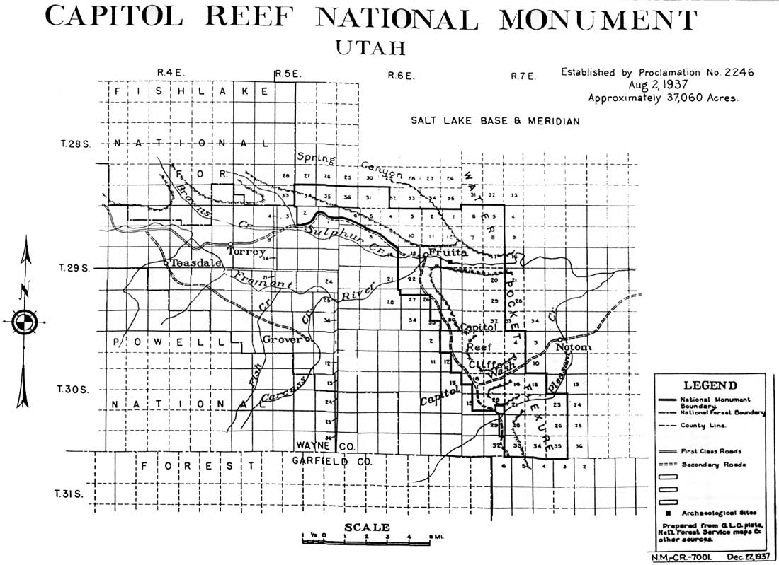
|
| Figure 52. State lands included within 1937 Capitol Reef National Monument boundaries. T28S R6E S36 and T29S R6E S2 are state school trust lands. (click on image for an enlargement in a new window) |
When the boundaries were drawn, planners may not have known that the two sections (Salt Lake Meridian, T28S R6E S36 on top of Meeks Mesa, and T29S R6E S2, portion north of Utah 24's western entrance to the monument) were actually state sections. The monument's first development outline, released in 1938, mentions only one state-owned section, presumably T29 R7E S36. The other non-federal lands listed in 1938 were approximately 600 acres in private ownership and a 20-acre parcel, owned by Wayne County, on the high benches north of Pleasant Creek. [11]
With the next development outline in 1943, a more thorough survey had been completed and the extent of the non-federal lands within Capitol Reef was realized for the first time. Of the 36,337-acre monument, almost 2,500 acres (7 percent) were state land, 40 acres belonged to the county, and a little over 917 acres (3 percent) were privately owned. [12] Throughout the remainder of the 1940s, private inholdings in Fruita were the biggest management issue. Neither planning documents nor agency correspondence refers to any specific desire to resolve the question of the far more numerous state-owned lands within the monument.
State Lands During The Uranium Boom: 1950 -
1954
With the arrival of the uranium boom in the late 1940s came a real possibility that the assumed wastelands of Capitol Reef would soon be opened to mining exploration. Since the state-owned lands were not under direct control of the National Park Service, they posed an immediate concern.
In February 1950, Zion National Park Chief Ranger Fred Fagergren was sent to Salt Lake City to investigate the status of state lands within Zion and Capitol Reef. According to Fagergren, the state's land records showed that none of the school sections within Capitol Reef National Monument were under any valid leases. Despite that advantage, attempts failed to work out a preemptive exchange before the situation changed, mostly because of internal conflicts between the governor and the state land commissioner. [13]
Fears that these state sections could be leased to uranium miners were realized when Michael O'Reilly of the La Fortuna Mining Company began excavating on a state section (T29S R6E S36), immediately south of the Oyler Mine tunnels. O'Reilly claimed that he had a valid mining lease from the Utah State Land Office. He also claimed to have signed another lease for 40 acres on the state section west Fruita (T29S R6E S16). Acting Superintendent Charles Kelly observed, "This quarter section lies within the boundary of the monument and within sight of the ranger station. While there is no uranium on this particular piece of land, it obviously could be used for a hot dog stand or filling station." [14]
Zion National Park Superintendent Charles J. Smith was also concerned about the potential mining scars on Section 36, but lamented, "Apparently we have no recourse to prevent the state from leasing the land and letting the miners work it." Smith elaborated, "I regret that we have been unable to exchange state lands in the area, but it takes two to make a bargain and the state has not evinced particular interest in making the exchange. It may be that in the future we can get the land within the boundaries, but in the meantime we'll just have to grin and bear it." [15]
Smith hoped that no uranium would be found, thus discouraging future prospecting in the rest of the monument. In a subsequent memorandum to his regional director, Smith worried that these state mining leases within Capitol Reef would prevent any further progress toward a state/federal land exchange. [16] Assistant Regional Director and former Zion National Park Superintendent Preston Patraw immediately wrote the Bureau of Land Management's regional administrator to voice similar concerns. According to Patraw, a tentative exchange had been previously approved by the new state land commissioner, but the state had not yet "checked" the specific lands to see if any involved Capitol Reef. [17]
BLM Regional Administrator H. Bryon Mock wrote about a month later with both good and bad news. The bad news was that the proposed land exchange did not include any state-owned sections within Capitol Reef National Monument. The good news was that, despite previous claims, no valid mineral leases had yet been issued within the monument's boundaries. [18] Two years later, during another abortive attempt to exchange the state lands within the monument, Administrator Mock sent a detailed status report on the state sections within Capitol Reef National Monument. This report also stated that no valid leases were recorded for any of the state's lands. [19]
Then, in February 1954, Charles Kelly noted in his monthly narrative report that a road had been dug through Section 36 south of Grand Wash and that mining had commenced. [20] Actually, the Yellow Joe and Yellow Canary mines to which Kelly refers were north of state-owned T29S R6E S36, and the claims were filed with the General Land Office but did not involve a state lease. It appears that Kelly and the La Fortuna Mining Company were confused as to the exact location of the state section, the location of the mineral lease, or both. [21]
State Lands Exchange Proposals: 1954-1967
In April 1954, the National Park Service, Bureau of Land Management, and members of the Utah State Land Board met to discuss the possibilities of land exchanges in Zion and Capitol Reef. While all sides appeared interested in making a deal, the state's uncompromising insistence on retaining mineral rights to the state sections and its desire to develop the recreational potential of those lands stalled the process once again. [22] This pattern of tentative agreements breaking down over opposing objectives is seen repeatedly throughout the state lands issue over the next 40 years.
Frustration over the inability to acquire the state sections was even cited as one reason for the National Park Service's reluctance to develop Utah's national parks and monuments. For example, during 1955, the Utah congressional delegation held meetings throughout southern Utah in order to drum up support for improving the National Park Service sites and thereby stimulate local economies. At these meetings, Zion National Park Superintendent Paul Franke pointed out that the National Park Service had not given priority to developments in southern Utah because of "the complicated land ownership within the areas." This included state as well as private inholdings. [23]
The problem with state lands grew following the small expansion of Capitol Reef in 1958. In order to secure land surrounding Utah 24, some 3,040 acres were added to the western side of the monument. The boundary was expanded south to Sulphur Creek, west to enclose all of Danish Hill below Fruita, and a little south toward Sleeping Rainbow Ranch. A result of this expansion, however, was that the remainder of two state sections were also added to monument lands. These were the part of T29 R5E S2 south of the old road's western entrance to the monument, and the remaining portion of T29S R6E S16 immediately west of Fruita. [24] Both Section 2, which was right on the western boundary, and Section 16, which included the higher benches west of Fruita, were prime locations for tourist development leases. Thus, the minimal 1958 expansion significantly increased potential conflicts over state-owned lands within Capitol Reef National Monument. Attempts to exchange or purchase these new sections would prove just as difficult as previous efforts.
In the spring of 1962, it appeared that some kind of exchange had been worked out that would significantly reduce the amount of state lands within Capitol Reef National Monument. However, the state sections that were to be transferred had never been formally surveyed prior to their withdrawal when Capitol Reef was created. Since they had not been surveyed before withdrawal, they were thus never eligible to be state school trust sections in the first place. It is possible that this was some kind federal transfer of lands outside the monument to the state in lieu of those withdrawn sections, but the documentation is not clear. In other words, while the transfer looked good on paper, it meant that no land within Capitol Reef really changed hands. Thus, by 1962, the four complete state-owned sections within Capitol Reef National Monument continued to be T28S R5E S36, T29S R5E S2, and T29S R6E S16 and S36. [25]
Then, in 1967, there was a major breakthrough. The previous fall, federal and state officials had worked out a tentative agreement that would enable the National Park Service to acquire two sections, T28S R5E S36 and T29 R6E S36, within the monument. However, a snag developed when local rancher Joe Hickman objected to the exchange because it would threaten his state grazing leases on the T28S section, which included a portion of Meeks Mesa. Hickman also had state grazing leases for Section 2 on the western monument boundary. He was, however, ready to deal. By March, an agreement had been reached among the state of Utah, Bureau of Land Management, the National Park Service, and Hickman, allowing Hickman to continue grazing on Meeks Mesa for eight more years under a special-use permit monitored by the BLM. [26] In exchange, Hickman agreed to cancel both of his state grazing leases. This freed up the only known encumbrances to the two Sections 36, and they were acquired by the National Park Service. [27] Section 2 was left out the 1967 land exchange and was acquired in 1976, in exchange for a Bureau of Land Management section in Castle Valley northeast of Moab. [28]
Thus, by the end of 1967, the number of state school trust sections within Capitol Reef National Monument had been cut in half, with possibilities of acquiring an additional section (Section 2). This would have left the state school section immediately west of Fruita as the only potential development threat. This, coupled with the purchase of most of Fruita inholdings, meant Capitol Reef was finally acquiring the non-federal holdings.
Unfortunately, portions of the remaining state section had been leased by Capitol Reef Lodge owner Clair Bird in 1964 for commercial and mineral extraction purposes. As told in Chapter 15, Bird confirmed park management's worst fears. He first built a gas station next to the highway and in full view of the visitor center. Then, just as Capitol Reef National Monument was dramatically expanded and debate ensued as to its final national park boundaries, Bird began a flagstone mining operation that became one of Capitol Reef's most controversial issues. [29]
Bird's ability to develop such sensitive lands with minimal National Park Service input is the classic illustration of the conflicts posed by state school sections within National Park Service boundaries. Attempts had been made throughout the 1950s and 1960s, mostly by the National Park Service, to acquire these lands, but either timing or specific terms prevented this from happening.
State Lands During The Expansion Debates:
1969-1971
When Capitol Reef National Monument was expanded in January 1969, the additional 215,000 included 23,680 acres of state school sections. Just as it seemed the non-federal land problems were being reduced, they increased as dramatically as the monument itself. At first, it seemed that these state sections would be only a minor irritant, just as they had been in 1937 and 1958. During the Johnson Administration's internal debate over the amount of National Park Service land to be added to the monument during the president's last days in office, there was no known consideration of the long-term effects that isolated state sections might have on Capitol Reef's management. [30] And throughout the various hearings and debates over the exact boundaries of a Capitol Reef National Park, the amount of state land is mentioned almost as an afterthought.
Even among those opposed to the expansion, the loss of grazing and multiple-use of the entire public domain was of far greater concern that the enclosure of almost 24,000 acres of school trust lands. [31] Both sides seemed to assume that, whatever the final boundaries, the state sections would soon be acquired by donation or exchange. [32] In the end, however, the various boundary compromises (due to other concerns) reduced state-owned lands in the park to fewer than 20,000 acres. The final language of Capitol Reef National Park's enabling legislation briefly stated that "lands or interests therein owned by the state of Utah, or any political subdivision thereof, may be acquired only with the approval of such State or political subdivision." [33]
State Lands, Private Lands And Lease Purchases:
1971-1978
Only three months after the monument was expanded in January 1969, a list of state sections was drawn up by the regional office in Santa Fe to facilitate a land exchange dialogue. [34] Yet, in a September 1971 briefing statement, Capitol Reef Chief Ranger Bert Speed communicated his frustration with the lack of progress toward such an exchange. Speed blamed the delay on the reluctance of the Bureau of Land Management's state director and on practices of the Utah State Land Board. [35] Except for the 1976 exchange of the state section on the park's western boundary (through which Utah 24 passed) for Bureau of Land Management land northeast of Moab, progress toward a land exchange for all 20,000 acres of state-owned land was stalled throughout the rest of the 1970s.
State leases also complicated the exchange of state lands within the park for other federal lands outside the park. After all, Utah was attempting to earn revenue from these sections to help pay for education expenses. For example, virtually every acre the state either owned or held rights to had a state grazing lease attached. These leases were spread among the various permittees of Capitol Reef and accounted for over 1,300 AUMs. [36]
Another hindrance was the various mining leases granted on state sections, and the subsurface mining rights that the state retained on land sold outright to various individuals. For example, the 1961-62 acquisition of a 40-acre private parcel east of Fruita (NE1/4SW1/4 T29S R6E S13,) for the new road's right-of-way was held up because the state retained the sub-surface mineral rights. Even though the BLM's mineral survey team had appraised the value as "nominal," the state wanted to hold all existing mineral rights lest it set a precedent for state land acquisition in the newly proposed Canyonlands National Park. While a declaration of taking was eventually secured without the mineral rights, these negotiations indicated that future state-held encumbrances would be difficult to acquire. [37]
When Capitol Reef National Park was established in 1971, it inherited several state-owned reserved mineral interests that did not have current leases attached. These included the 40 acres in Section 13 immediately east of Fruita, as well as reserved mineral interests to Section 16, previously leased to Clair Bird. Two other portions of state-owned mineral interests with no current leases were held in the southern end of the park. [38]
Project Bold: 1979-1984
According to Capitol Reef's 1984 "Statement for Management," the primary objectives of this new land exchange effort, termed Project Bold, were to "improve the land management potential of both state and federal lands, to eliminate unnecessary federal/state conflicts generated by existing ownership patterns, and to facilitate the management of state owned land by substantially realigning the scattered state sections and creating new blocks of state lands." The statement noted, "The State school sections may eventually come under Federal ownership." [39]
While Project Bold was a fresh approach, especially since it was begun at the state level, it too soon stalled. The National Park Service, for one, was concerned that residual grazing and mineral leases on the state sections would prove incompatible with park management. The agency, however, was unwilling to voice these concerns for fear that the state would pull out of the deal. This was only one of the many problems that needing resolution before any agreement was concluded. [40]
As it turned out, there was not enough time to work out these problems with Project Bold. Initially proposed in the late 1970s by Matheson, it was 1984 when Rep. Jim Hansen introduced a bill in Congress. After one hearing, little else was done for Project Bold during that session. This effectively killed the entire project, as Matheson retired after the 1984 election and the new Republican governor, Norman Bangerter, seemed uninterested in his Democratic predecessor's state-wide proposal. [41] Instead, Bangerter focused on smaller exchanges, such as a plan to acquire 50,000 acres surrounding the Lake Powell marinas.
Burr Trail State Section Transfer: 1987-1994
Bangerter's proposal for small, individual land exchanges is mentioned in Capitol Reef's 1987 Statement for Management as the only realistic option then available to the National Park Service. [42] Notably, by 1987, all the state's mineral leases within the park had expired and there were no immediate concerns regarding any of the state sections within the park. This state of affairs quickly changed, however, at the end of 1987, when the state transferred T34S R8E S16, astride the Burr Trail, to Garfield County ownership. [43] While Garfield County assured Capitol Reef managers that this exchange was made only to pressure Congress to release appropriated money for paving the Boulder-Bullfrog Road, park managers worried about the development possibility of this accessible and lovely tract of non-federal land. In response to Garfield County's actions, the National Parks and Conservation Association successfully asked for an injunction from the Utah State Supreme Court to prevent any use of the land other than standard road maintenance. This injunction is still in effect as of March 1995. [44]
State/Federal Land Exchange Proposals:
1988-1994
During 1988, Utah Rep. Wayne Owens introduced a bill to try once again for a state-wide exchange of federal lands for state-owned inholdings. On May 20, 1988, the House Subcommittee on National Parks and Public Lands held a field hearing in Salt Lake City. At this hearing, both state officials and representatives from the environmental community objected to the bill's provisions. Governor Bangerter continued to oppose a state-wide initiative in favor of more selective exchanges, such as the one proposed for Glen Canyon National Recreation Area. Terri Martin, regional representative of the National Parks and Conservation Association, was concerned that the bill provided the state with an open invitation to acquire and develop mineral-rich federal lands in scenic or environmentally sensitive areas. According to Martin, this would result in more damage than would maintaining the status quo. After the hearing, no further action was taken on Owens's bill. [45]
For the next four years there was little mention of proposed land exchanges in Capitol Reef's reports and memoranda. In 1992, Governor Bangerter asked the Utah congressional delegation to try once again to get land exchange authorization through Congress. Hansen and Owens sponsored slightly different versions of a state-wide exchange of state school trust sections within various federal reservations in return for federal land, mineral rights and/or additional revenue. [46]
On June 16, 1992, a hearing in Washington, D.C. on these and similar bills was held before the House Subcommittee on National Parks and Public Lands, chaired by Bruce Vento of Minnesota. Republican Jim Hansen's bill was more enthusiastically endorsed by Governor Bangerter because it would bring substantially more money into the state's education fund. Hansen's H.R. 4769 would require that all state sections held within Utah's national parks, monuments and recreation areas would be turned over to the National Park Service. In return, the state would receive an additional 25 percent (beyond the 50 percent already required by law) from all federal mineral receipts in Utah for the next 25 years. According to figures released during the bill's hearing, the total compensation to the state of Utah would be about $663.5 million, or roughly $8,000 an acre. [47] This was a great deal more than the $125-150 an acre estimate of the National Park Service. [48]
Democrat Wayne Owens's bill also stipulated payment for these state sections within Utah's parks, but his H.R. 5118 would cap federal compensation through these same mineral revenues at $170 million, or about $2,000 an acre. [49] Needless to say, the Department of Interior spokesman, BLM Director Cy Jamison, did not favor either of these proposals. Jamison argued that any land exchanged should be about equal in value. According to Jamison, an agreed upon value should be derived by skilled appraisers rather arbitrary formulas specified by the proposed legislation. [50]
Both sides saw additional problems with the two bills, yet this time both were willing to negotiate in good faith. Governor Bangerter said in a prepared statement to the subcommittee, "I believe the method of payment is fair, and quickly moves much needed money into the schools of our state. However, we are also willing to accept land or interests in mineral resources....We are willing to negotiate the value of our lands based on appraisal....In summary, I want to emphasize that the state is willing be to flexible in this process." [51]
Bangerter, however, did warn that if an administrative or legislative solution could not be reached, the state might initiate mining or other developments within National Park Service lands and to go to court to defend those actions. [52]
BLM Director Jamison likewise asserted the Department of Interior's desire to be flexible. Recognizing that disagreements regarding the actual value of the state inholdings had derailed past state/federal land exchanges, Jamison acknowledged a need to "keep the momentum" on negotiations. [53]
It thus appeared that both sides truly wanted and needed a resolution to a state lands problem that was continually growing worse. Finally, on Oct. 1, 1993, a compromise "Utah Schools and Lands Improvement Act" was signed into law. [54] This act would provide for the eventual transfer of 80,000 acres of state school trust sections that are within National Park Service boundaries, as well as 80,000 acres in national forests and 40,000 within Indian reservations. Along with the lands, both surface and subsurface rights are to be transferred. In return, the state will receive a relatively small amount of land with existing mineral leases or other valuable assets (such as a ski area), and up to $50 million in federal mineral royalties. [55]
According to Richard A. Young, Chief of the Rocky Mountain Region's Land Resources Division, once the appraisal process is settled, the actual surveys should be quickly completed. The lands will be evaluated for potential minerals, tourist development revenues, or other factors that may increase the state's compensation. A separate federal survey will also determine if any of the state sections contains hazardous waste sites (such as current or abandoned uranium mines) or other potential problems that must be cleared before the land is actually transferred. [56]
Post-Park Private Lands
The remaining few pieces of non-federal land within Capitol Reef National Park were private lands that were not purchased in the early 1960s or that were part of the1969 expansion. By the end of 1969, long-time Fruita resident Dewey Gifford had sold his house, barn, and 12.28 acres of land for $41,000. [57]
The next tract to be acquired was a former state section purchased outright by ranchers Rulen and Inez Morrell. This section (T26S R5E S36) was desirable because it was strategically placed between Upper and Lower Cathedral Valleys, encompassed the Caineville Wash/Baker Ranch/Fremont Junction road intersection, and included some spectacular monoliths, igneous dikes, and the Gypsum Sinkhole. The National Park feared that the Morrells would sell the land to development interests. [58]
The National Park Service's Utah Land Office initially offered to buy the Morrells' rights for $22,400. Rulen Morrell responded that his grazing interests made his land worth at least $200 an acre ($128,000 for the entire 640-acre section) but that he was willing to "get together on a price." [59]
In May 1972, the National Park Service sent Realty Specialist Lee Garrison to negotiate with the Morrells at their home in Fremont. Garrison reported, "We argued, bickered, and negotiated on every reason we could think of why they should sell to the Park for the appraised price of $22,400. Mr. Morrell is 64 years old and has had two heart attacks in the last six months, and we finally signed them up with a life's estate grazing use of the section." [60]
In the end, Garrison was pleased that he was able to get the Morrells to sell for the appraised value of $35 an acre. [61]
The Bird property and leases, the Sleeping Rainbow Ranch on Pleasant Creek, and a former state section purchased years before by Wonderland Stages were next on the list. Unfortunately, Capitol Reef National Park's enabling legislation had set a $423,000 ceiling on private land purchases -- not nearly enough to purchase all the private tracts. [62] Thus, all land deals were off until 1976, when Congress increased acquisition funds to $2,173,000. [63] The next year, the section owned by Wonderland Stages, a commercial tour guiding service operated by Salt Lake residents John and Stewart Campbell, was purchased for $275,000. This purchase enabled the National Park Service to acquire the historic Behunin cabin, the man-made waterfall, and the abandoned meander of the Fremont River near the eastern boundary. In 1978, Clair Bird's Capitol Reef Lodge and state land leases were acquired by condemnation of taking for almost $400,000. [64]
This left only two private parcels of land within the park: the Sleeping Rainbow Ranch owned by Lurton and Alice Knee, and a .42-acre tract, owned by descendants of Fruita pioneer Amasa E. Pierce, near the junction of Sulphur Creek and the Fremont River.
Sleeping Rainbow Ranch Purchase: 1974-1994
When Capitol Reef National Monument was expanded in 1969, approximately 300 acres owned by Lurton and Alice Knee at Pleasant Creek became an inholding. This area had been first settled by Ephraim K. Hanks and his family in 1882. They later built the first permanent house in what is now Capitol Reef National Park. After Ephraim's death, his wife Thisbee gained title to 160 acres through the Homestead Act in 1899. From 1916 to 1937, the Floral Ranch passed through several hands before being purchased by Ezra and Levi Bullard of Torrey. [65]
By 1940, the Bullards had wearied of the ranch's isolation, so they sold the Floral Ranch to Lurton Knee and his first wife, Margaret. Knee, who had worked with his brother-in-law Tom Goulding in Monument Valley, investigated the potential of starting his own tourist business near Capitol Reef National Monument. The Knees saw the Pleasant Creek location as perfect for starting a guest ranch and tour business patterned after the Goulding operation. Throughout the 1940s, the Knees struggled to survive by raising a few cows and pigs. (It was during this time that the dilapidated Hanks house on the north bank above Pleasant Creek was burned to the ground by Knee's ranch hand.) After the end of World War II, the Knees began to plan their tourist business, the Sleeping Rainbow Ranch. [66]
By the time the monument encompassed their land in 1969, the Knees had built a house, cabins, and a small, concrete block motel on a knoll overlooking horse corrals and fenced pastures. They had maintained an irrigation canal, spring and pump water system, and had constructed a power/telephone line through the Pleasant Creek Gorge to the west. The Knees' acreage was now up to the approximately 300 acres, with a lease on an adjoining state section, as well. [67]
Lurton Knee later recalled that he actively supported the expanded monument and later park boundary lines, fully aware that the boundary would make him an inholder. He stated in 1992, "I had to debate then on whether to enlarge, go on and make a larger guest ranch out of it or to sell it to the national park, because I knew then I became an in-holder." [68]
Because of the insufficient $423,000 initial cap placed on private land acquisitions in the 1971 legislation, acquisition of the entire Sleeping Rainbow Ranch had to be delayed. Meanwhile, 140 acres of the ranch were purchased for $300,000 in the fall of 1974. [69] When the acquisition ceiling was raised in 1976, the Knees realized that their chance to sell the rest of their property was at hand. They decided to sell their land to a church, thereby establishing a tax-free trust fund that would provide them with steady retirement income. The chosen church would then sell the land to the National Park Service. The other key provision of any deal would be that the Knees and their children would be granted life residency to a portion of the land. [70]
Around 1976, the Knees approached officials at Brigham Young University in Provo, Utah, with their proposal. The university, in consultation with the Church of Jesus Christ of Latter-day Saints, determined that it could not meet all of Lurton Knee's stipulations. The Knees then revised their life estate requirement, dropping their children from the provision, and turned to the more flexible Seventh Day Adventist Church. [71]
In January 1978, earnest negotiations began between the National Park Service and Lurton and Alice Knee. Sherman W. Swenson, National Park Service Chief of the Division of Land Acquisition, spent a day with the Knees hammering out an initial deal. The Knees agreed to sell 235 acres, so long as they could retain 25 acres as a life estate. They would also retain rights-of-way for their spring and pump water system, root cellar, the power and telephone lines, and the rights to water and pasture necessary to keep three horses. Swenson reported, "It is my recommendation that we go along with their requirements. The price is okay. Our only alternative to this is condemnation, and in light of the present climate regarding our use of condemnation, I would recommend against it." [72]
By April 1978, the formalities of a purchase agreement had been worked out among the Knees, the Southern California Branch of The Seventh Day Adventist Church, and the National Park Service. The NPS would acquire the 235 acres for $450,000. In June 1978, an additional $17,805 were paid directly to the Knees for 11.87 acres of their life estate. [73]
Lurton Knee died in the early 1995. Currently, the area is used primarily for trailhead parking by hikers using Pleasant Creek trail, and by four-wheel drive and mountain bike enthusiasts passing by along the South Draw Road.
Archeological and historic surveys of the area have demonstrated the need to protect this impressive entrance to the Waterpocket Fold. The Knees' old guest ranch facility is now under consideration for use as a university-operated environmental education and research center. The area is also a potential location for future park housing or visitor facilities.
Tract 01-161, The Pierce/Tanner Land:
1980-1994
In one of the numerous small land transactions within Fruita prior to the National Park Service's arrival, a small parcel of land, only .42 acres, was somehow overlooked. This situation may have arisen from of the inaccurate, confusing manner in which the various individual orchard farms were identified. Another reason may be that the tract was located within the Fremont River floodplain immediately downstream from the junction of Sulphur Creek. Thus, either the spring run-off or the numerous flash floods descending the Fremont River or Sulphur Creek drainages would occasionally inundate this tiny piece of land. [74]
When the National Park Service began purchasing the private Fruita inholdings in the 1940s and 1960s, this small parcel was overlooked once again. It was not until the late 1970s or early 1980 that some National Park Service official realized that there was a gap between acquired lands. The National Park Service set out to find the last legal owner and his or her heirs of the property and then offer to purchase the land at its appraised value. [75]
By the end of 1980, the Sixth District Court in Wayne County had validated the National Park Service's findings that tract 01-161 had last belonged to Amasa E. Pierce, who died in 1933, and that there were 22 living heirs. [76] The next task for the National Park Service was to track down those heirs and have them either convey their interests in the land to one family member willing to sell, or come to some other consensus as to how the land was to be disposed. The appraised value of the .42 acres was calculated at $2,000. [77]
At first the closest living descendent, daughter Romania Pierce Tanner, countered with an offer to sell the land for $2,500. However, she was unable to get all the other heirs to agree to this. Then, some of the descendants of Amasa Pierce offered to sell the land to the National Park Service if half the amount could go to a park memorial to their grandparents. Superintendent Derek Hambly advised the family that the proposed transaction was against National Park Service policy. The heirs then suggested that an additional room at the visitor center or some kind of picnic shelter honoring all the Fruita pioneers might be possible. According to Pierce family spokesman Leah P. Johnson, this offer was also denied by park management. Accordingly, the heirs decided that they would simply take all the money and divide it among themselves. [78]
The National Park Service then offered to pay the $2,500 asked by Romania Tanner, but this was dropped "because 19 heirs could not agree on conveying their interest." [79] While the heirs were trying to reach an agreement, the Secretary of the Interior issued an order in early 1981 that stopped all land acquisition attempts until further notice. Thus, the sale of tract 01-161 was postponed indefinitely. [80]
There were no new developments on the tract for seven years. Then, in June 1988, two Pierce family descendants, Max and Blaine Tanner, went to Fruita to inquire about possible uses or sale of their land. By this time, failure to pay back taxes on the land (added to the Wayne County rolls upon its discovery in the early 1980s) had almost eliminated the Pierce descendants' claims. Four distantly related family members, including Max and Blaine Tanner, paid the required $450 in back taxes. While this payment kept the Pierce claim viable, at least all future negotiations would involve only those who had paid the taxes. [81]
During this June 1988 meeting, the Tanners told Chief Ranger Poe they wanted to put a cabin or camping trailer on the site for recreational use. Poe explained that this would be in violation of National Park Service policy. Poe also pointed out that since virtually the entire land was within the Fremont River's immediate floodplain, it would simply be easier for everyone if they would sell out. [82]
In June 1989, Max Tanner notified the National Park Service that the remaining owners of the Pierce property were now willing to sell for $6,000. Tanner dismissed the argument that the land was of little value because its location, and stated that it had great potential for development once minor problems of access were overcome. [83] This "minor" problem was the fact that the Tanners would have to get an easement over national park land from Utah 24 -- an easement that the National Park Service was not about to grant. Richard A. Young, Rocky Mountain Region Chief of the Land Resources Division wrote Tanner a curt response. Young stated flatly that the National Park Service was not willing to negotiate on its latest offer of $1,000, less than half what the land would have sold for in 1980.
Max Tanner responded that his family had decided to use the land as a vacation site and that they would be willing to pay for the necessary easement. [84] This offer was also summarily rejected, this time by Homer L. Rouse in the capacity of Acting Regional Director. [85]
As of March 1995, the status of Amasa Pierce descendant's property, tract 01-161, is not resolved. As long as the National Park Service is able to control access to the site, it can not be utilized for anything other than a walk along the river.
REFERENCES
Books And Department Of Interior Documents And
Publications
Gilbert, Cathy A., and McKoy, Kathleen L. "Cultural Landscape Report: Fruita Rural Historic District, Capitol Reef National Park." Draft prepared for National Park Service, Rocky Mountain Region, Cultural Resources Division, July 1993.
National Park Service. "Capitol Reef National Park: Statement for Management." 1984, 1987, 1989, 1993 (Draft).
O'Bannon, Patrick W. "Capitol Reef National Park: A Historic Resource Study." Prepared by John Milner Associates, Inc., Philadelphia, under contract for National Park Service, Rocky Mountain Regional Office, Denver, 1992.
"Proposed Wilderness, Capitol Reef National Park Utah: Draft Environmental Statement," National Park Service, Denver Service Center, 1974.
White, Richard. "It's Your Misfortune and None of My Own": A History of the American West. Norman: University of Oklahoma Press, 1991.
Newspapers
High Country News. 18 July 1988, 25 July 1994.
Salt Lake Tribune. 22 November 1955, 5 January 1988.
Other Federal Records
Code of Federal Regulations. Vol. 3 (1954-1958 Compilation):160.
Congressional Record. Washington, D.C., 1969-1993
U.S. House Committee on Interior and Insular Affairs, Subcommittee on National Parks and Public Lands. To Exchange Lands Within The State of Utah. 102nd Cong., 2nd sess., 1992. Serial No. 102-97.
U.S. Senate Committee on Interior and Insular Affairs. "Establishing the Capitol Reef National Park in the State of Utah." 91st Cong., 2nd Sess., 1970. Senate Report 91-989.
U.S. Statutes at Large. 28(1894): 107; 50(1937):1856; 85(1971): 739-740; 107(1993):95.
Archives
Capitol Reef National Park, Torrey, Utah:
Active Superintendent's Files
Historic Superintendent's Files
Capitol Reef National Park Archives
Resource Management Files
Lyndon B. Johnson Library, Austin, Texas:
Dorothy Territo Staff Files
Office of President Files, Box 12. "Udall-National Monument."
National Archives - Rocky Mountain Region, Denver, Colorado
Record Group 79 - Records of the National Park Service Accessions:
79-60A-354
79-67A-505
79-73A-136
National Archives - Suitland, Maryland
Record Group 49: Records of the U. S. Grazing Service
Administrative Records 1935-1946
Interviews
Bullard, Billie. (Rancher, Floral Ranch) Interview with Bradford Frye. Tape recording, 30 January 1991. Capitol Reef Archives.
Knee, Lurton. (Tour Operator, Sleeping Rainbow Ranch) Interview with Bradford Frye. Tape recording, 18 September 1992. Capitol Reef Archives and Marriott Library Special Collections, University of Utah, Salt Lake City, Utah.
Lundy, Charles V. (Superintendent, Capitol Reef National Park) Telephone interview with Bradford Frye. Tape recording, 29 July 1994. Administrative History Files and Notes, Capitol Reef Unprocessed Archives.
Young, Richard A. Telephone interview with Bradford Frye. Notes, 21 September 1994, Administrative History Files and Notes, Capitol Reef Unprocessed Archives.
FOOTNOTES
1 The author thanks Richard A. Young, Rocky Mountain Region Chief of Land Resources, for his help in filling in some of the gaps in these complicated land transactions and for correcting information from earlier drafts.
2 See Chapters 5, 7, 13, and 14. Also see Patrick W. O'Bannon, "Capitol Reef National Park: A Historic Resource Study," prepared under contract for the National Park Service, Rocky Mountain Region, June 1992, and Cathy A. Gilbert and Kathleen L. McKoy, "Cultural Landscape Report: Fruita Rural Historic District, Capitol Reef National Park," draft prepared for National Park Service, Rocky Mountain Regional Office, Denver, July 1993.
3 Richard White, "It's Your Misfortune and None of My Own": A History of the American West (Norman: University of Oklahoma Press, 1991), 137-138.
4 Act of 16 July 1894, U.S. Statutes at Large 28 (1894):107.
5 In 1930, there were 23 million acres of federal lands in Utah, of which 11.5 million had yet to be surveyed - "Activities of the General Land Office in Various States," 28 September 1930, Box 12, Entry 992, Letters to Secretary of Interior, 1 July 1930-31 December 1937, Records of the U.S. Grazing Service, Administrative Records 1935-1946, Record Group 49, National Archives, Suitland, Maryland, 9.
6 O. P. DeJulio, Acting State Director, Bureau of Land Management, to Superintendent Krueger, 5 April 1962, File L1425, Accession 79-67A-505, Container 342490, Box 1, Records of the National Park Service, Record Group 79 (RG 79), National Archives - Rocky Mountain Region, Denver, Colorado (all RG 79 records from this repository unless otherwise stated); also see File L1425, Capitol Reef National Park Historic Superintendent's Files.
7 Toll to National Park Service Director, 8 November 1932, Box 1, Folder 1, Capitol Reef National Park Archives.
8 Toll to NPS Director, 13 April 1934, Box 1, Folder 1, Capitol Reef National Park Archives, 2-3, 9.
9 Preston P. Patraw, "Proposed Wayne Wonderland (Capitol Reef) National Monument," 3 August 1935, Box 1, Folder 2, Capitol Reef National Park Archives, 4. See Chapter 8 for more details on the various boundary proposals.
10 Presidential Proclamation, "Capitol Reef National Monument, Proclamation 2246," U.S. Statutes at Large, 50 (2 August 1937):1856.
11 Ibid.; "Development Outline for Capitol Reef National Monument," 1 March 1938, File CR-600-01, Accession 79-60A-354, Container 63180, Box 2, RG 79, 1. Another small parcel of a state section, T29 R7E S16 (north of Utah 24's right-of-way as it descended down into Fruita) was also not known to be within the monument at this time.
The history of the county-owned land north of Pleasant Creek has not been researched, although on-site evidence indicates it was used for grazing. The county land was within T30S R7E S20, which apparently had been added to state-owned lands in 1910. (H. Bryon Mock, Regional Administrator, Bureau of Land Management to Acting Regional Director Hugh M. Miller, 29 May 1953, File L1425-Utah 51-74, Capitol Reef Historic Superintendent's Files). This parcel was purchased by the Zion Natural History Association and donated to the National Park Service in May, 1969 (Master Deed Listing, 19 April 1993, File L1429, Capitol Reef Superintendent's Files).
12 "Development Outline for Capitol Reef National Monument," January 1943, File CR-600-01, 79-60A-354, Box 2, RG 79, 8.
13 Fagergren to Zion Superintendent, 23 February 1950, File CR-600, Ibid. Capitol Reef was under Zion's jurisdiction from 1937 to 1960, except during a brief period in the 1950s.
14 Kelly to Zion Superintendent, 20 September 1951, Ibid. This was foresight on Kelly's part, as it was on this section that Clair Bird built his gas station in the 1960s and began a flagstone mining operation in the early 1970s.
15 Smith to Kelly, 24 September 1951, Ibid.
16 Smith to Regional Director, 24 September 1951, Ibid.
17 Patraw to BLM Regional Administrator, 28 September 1951, Ibid.
18 Mock to Patraw, 25 October 1951, Ibid.
19 Mock to Hugh M. Miller, 29 May 1953, File L1415, Accession 79-67A-337, Container 919498, Box 1, RG 79.
20 Superintendent's Monthly Report, February 1954, Box 4, Folder 3, Capitol Reef National Park Archives.
21 Further correspondence and court records related to La Fortuna Mining Company and its Yellow Canary Claim do not mention the land as state-owned. See Chapter 15, Mining.
22 Zion Superintendent Paul R. Franke to Regional Director, 20 April 1954, File L1415-Utah 51-74, Capitol Reef Historic Superintendent's Files.
23 Franke to D. H. Whittenburg, Chairman, Utah State Land Board, 25 November 1955, Ibid.; Salt Lake Tribune, 22 November 1955.
24 Presidential Proclamation, "Enlarging The Capitol Reef National Monument, Utah, Proclamation #3249," 3 C.F.R. 160 (1954-1958 Compilation); see Chapter 9.
25 O. P. DeJulio, Acting State Director, Bureau of Land Management, to Capitol Reef Superintendent, 5 April 1962, File L1425-Utah 51-74, Capitol Reef Historic Superintendent's Files. This is the only reference found in National Park Service records relating to this potential exchange. The Utah BLM and state records may contain more information.
26 Max C. Gardner, Director, State Land Board, to Harry P. Linder, Capitol Reef Superintendent, 23 January 1967, File L1425-Utah 51-74, Capitol Reef Historic Superintendent's Files.
27 Ibid.; "Agreement between the Bureau of Land Management and Joe Hickman," 2 March 1967, Ibid. Unfortunately there is no copy of the actual transfer agreement in the Capitol Reef files. A copy, if available, should be acquired from the State Land Office.
28 "Notification of Closing," 30 March 1976, File L1425-Utah 74-77, Capitol Reef Historic Superintendent's Files.
29 See L1425-Bird files, Capitol Reef Historic Superintendent's Files. A summary of the events related to the Bird leases on Section 16 is found in Chapter 15, Mining and Related Encroachments.
30 See staff files of Dorothy Territo, Office of President File, "Udall-National Monument," Lyndon B. Johnson Library, Austin, Texas, photocopies in Administrative History files and notes, Capitol Reef Unprocessed Archives. See Chapter 10 for more details on Secretary of Interior Stewart Udall's efforts to double the National Park Service lands from July 1968 to January 1969.
31 For examples see the newspaper clippings in Box 8, folders 3-5, Capitol Reef National Park Archives; also see Congressional Record, 91st Cong., 1st sess., 1969, 115:2402-2405.
32 Fred J. Russell, Under Secretary of Interior, to Senator Henry M. Jackson, Chairman, Committee on Interior and Insular Affairs, in "Establishing The Capitol Reef National Park in the State of Utah," Senate Report 91-989, 91st Cong., 2nd Sess., 1970, 3.
The final "stair-stepped" boundaries of Capitol Reef National Park were sometimes drawn around state sections and at other times included them. The decisions seemed more to do with other factors than just whether or not the land was a state school trust section.
33 P.L. 92-207, U.S. Statutes at Large, 85 (1971):739.
34 Philip O. Stewart, Chief, Division of Land and Water Rights, to Chief, Office of Land and Water Rights, SSC, 10 April 1969, File L1425-Utah 51-74, Capitol Reef Historic Superintendent's Files.
35 Speed, "Briefing Statement of Area Problems: State Sections Within the Park," 28 September 1971, File A6435, Accession 79-73A-136, Box 1, RG 79.
36 List of State Grazing Leases, 19 August 1982, Grazing Management Files-State Leases, Capitol Reef Resource Management Files. Also see Chapter 1, Grazing History.
37 See Thomas J. Allen, Regional Director, to NPS Director, 10 August 1962, File L1425-Utah 51-74, Capitol Reef Historic Superintendent's Files.
38 "Proposed Wilderness, Capitol Reef National Park, Utah: Draft Environmental Statement," National Park Service, Denver Service Center, June 1974, 35. Also see detailed revision of all non-federal land tracts as of 1974 in Garrison to Chief, Division of Land Acquisition, 29 July 1974, File L1425-Utah 74-77, Capitol Reef Historic Superintendent's Files.
39 "Capitol Reef National Park: Statement for Management," December 1984, 14.
40 High Country News, 18 July 1988; House, Committee on Interior and Insular Affairs, Subcommittee on National Parks and Public Lands, To Exchange Lands within The State of Utah: Hearings on H.R. 1808/S. 807, H.R. 5118, H.R. 4769, H.R. 4770, S. 1183. 102 Cong., 2nd sess., 16 June 1992, 32-33.
42 "Capitol Reef National Park: Statement for Management," July 1987, 28.
43 Salt Lake Tribune, 5 January 1988; see Chapter 16, Roads, Trails and Utilities.
44 See Superintendent's Annual Narrative Reports, 1987-1990, File A2621, Capitol Reef Superintendent's Files; Charles V. Lundy, Capitol Reef Superintendent, telephone interview with Bradford Frye, 29 July 1994, tape on file with Administrative History files and notes, Capitol Reef Unprocessed Archives.
45 High Country News, 18 July 1988; Subcommittee Hearings, 16 June 1992, 33.
46 Subcommittee Hearings, 8-34.
50 Subcommittee Hearings, 16 June 1992, 189-190.
54 P.L. 103-93, U.S. Statutes at Large, 107 (1993):95.
55 High Country News, 25 July 1994; Richard A. Young, Chief, Land Resources Division, Rocky Mountain Region, telephone interview with Bradford Frye, 21 September 1994, notes on file in Administrative History files and notes, Capitol Reef Unprocessed Archives.
56 Ibid.; Charles Lundy, telephone interview, 29 July 1994; Richard Young, telephone interview.
57 "Master Deed Listing; Status of Lands as of 31 March 1993," File L1429-Land Records, Capitol Reef Superintendent's Files.
58 Tract 158-01-113, "Program Tract Acquisition Proposal," 14 July 1971, File L1425-Morrell, Capitol Reef Historic Superintendent's Files.
59 Morrell to State Land Office, 19 March 1972, Ibid.
60 Garrison, "Negotiator's Progress Record," 12 May 1972, Ibid.
61 Ibid.; Warranty Deed dated 2 August 1972, Ibid. Rulen Morrell died in 1976.
63 See Chapter 15, for details on this legislation related to purchasing Clair Bird's mineral and commercial leases and property.
64 1993 Master Deed Listing. Unfortunately there is not much information on the Wonderland Stages land. During the appeal for more acquisition money in 1974, it was mentioned that the Campbells intended to either develop the land or sell to someone else - possibly Clair Bird. The land was initially appraised for $29,600, but the Campbells wanted $500,000; see Lloyd L. Garrison, Reality Specialist, to Chief Division of Lands, Rocky Mountain Region, 15 March 1974, File L1429-Land Records, Capitol Reef Historic Superintendent's Files.
65 Patrick W. O'Bannon, "Capitol Reef National Park: A Historic Resource Study," 40-41; also see Billie Bullard, interview with Bradford Frye, 30 January 1991, Capitol Reef National Park Archives.
66 Lurton Knee, interview with Bradford Frye, 18 September 1992, Capitol Reef National Park Archives; transcript and tape also in University of Utah Library Special Collections, Salt Lake City.
67 Ibid.; see File L1425-Knee, Capitol Reef Superintendent's Files.
68 Lurton Knee, interview with Bradford Frye, 18 September 1992, rough draft of transcript, 54.
69 1993 Master Deed Listing, File L1429-Land Records, Capitol Reef Superintendent's Files.
71 Ibid.; Sherman W. Swenson, Chief, Division of Land Acquisition, to John Cunningham, Brigham Young University, 8 December 1976, File L1425, Capitol Reef Superintendent's Files.
72 Swenson to Superintendent Frank Wallace, 1 February 1978, File 1425-Knee.
73 1993 Master Deed Listing; "Offers to Sell" and "Warranty Deeds," Ibid.
74 See File L1425-Tanner, Capitol Reef Superintendent's Files.
75 Richard A. Young, telephone interview, 21 September 1994.
76 Probate #423-6, 14 October 1980, Sixth District Court of Wayne County, Loa, Utah, photocopy in File 1425-Tanner.
77 Lloyd L. Garrison, Acting Chief, Division of Land Acquisition, to Romania Pierce Tanner and others, 18 December 1980, File L1425-Tanner.
78 Leah P. Johnson to Garrison, 22 January 1981, Ibid. In a February 1981 letter, Lloyd L. Garrison of the Division of Land Acquisition informed Leah Johnson that it was indeed true that "funds available for the purchase of land could not be used towards a memorial." He did, however, advise that once the land was sold, the various individuals could pool and donate their money to Capitol Reef in exchange for a memorial plaque.
79 Max Tanner to Garrison, 26 June 1989, Ibid. In a June 1988 note from Chief Ranger Noel Poe to Superintendent Martin C. Ott, Poe stated that one of the Pierce descendants had insisted that the land was really worth $20,000 instead of $2,300 offered by the National Park Service. It is unknown when the $2,300 offer, if accurate, was made.
80 Garrison to Johnson, 23 February 1981, Ibid.
81 Regional Director to Regional Solicitor, 15 September 1989, File L1425-Gen. Correspondence, Capitol Reef Historic Superintendent's Files; Max Tanner to Lloyd Garrison, 26 June 1989, File L1425-Tanner, Capitol Reef Superintendent's Files.
82 Poe to Ott, 1 June 1988, File L1425-Tanner.
83 Tanner to Garrison, 25 June 1989, Ibid.
84 Tanner to Young, 28 August 1989, File L1425-Tanner.
85 Rouse to Tanner, 29 September 1989, Ibid.
| <<< Previous | <<< Contents >>> | Next >>> |
care/adhi/chap17.htm
Last Updated: 10-Dec-2002