|
Capitol Reef
Administrative History |

|
CHAPTER 16:
ROADS, TRAILS, AND UTILITY RIGHTS-OF-WAY
In the rugged Waterpocket Fold country, human access has historically been a concern. Led by stockmen and miners, newcomers have blazed roads and trails through narrow canyons and over rocky ridges to the wide open desert country east of the Waterpocket Fold. Because of the difficult terrain, few routes could be maintained. Even the roads that were at least graded remained extremely rough and rocky, effectively barring admittance to all but the most determined.
By the 1930s, businessmen and tourism boosters saw the lack of an all-weather road through southern Utah as the main reason the area remained poor and undeveloped. Cattle and sheep ranchers also wanted better roads to provide easier access to their winter grazing lands. Many were certain that after Capitol Reef National Monument was created in 1937, paved roads would follow. In fact, a key reason for campaigning for National Park Service involvement in the area was the belief that a park would bring about road improvements. Yet, nothing changed for 20 years.
Finally, in 1962, Utah Highway 24 was rerouted and paved through the Fremont River canyon. The new road brought more people into the area and changed circulation patterns in the monument and on surrounding lands. Within Capitol Reef, the old, traditional route through Capitol Gorge was closed by the park superintendent, and trails were built to accommodate hikers. Better access to the area encouraged more people to explore the region's backcountry. Easier travel and improved utilities benefited the local communities, stockmen, and entrepreneurs. As a result, some area businessmen and politicians continued to push for even more roads and utility corridors.
Demands for improved access coincided with the dramatic expansion of Capitol Reef National Monument in 1969 and its redesignation as a national park two years later. Concerns over transportation and utility access were key components of the congressional debate and final authorizing legislation. But even the call for wilderness and transportation studies could not resolve the growing dispute over how access should be controlled in the new park. The drawn out controversy over the paving of the Burr Trail road exemplifies the continuous conflict that typifies road development in southern Utah.
This chapter presents a historical chronology of the road and trail developments within the headquarters or old monument area, as well as on lands later incorporated into the monument and park. Specific analysis of the transportation and wilderness studies required by the park's enabling legislation, the 1982 Capitol Reef General Management Plan, the ongoing Burr Trail controversy, Revised Statute 2477, and a separate segment on power and telephone rights-of-way conclude this chapter. Since roads, trails, and utilities are a fundamental part of park operations, the other chapters of this administrative history should be cross-referenced.
Early Monument Roads and Trails
Roads Before 1937
Because only a few hundred people settled the rugged terrain of south-central Utah, state- or county-sponsored road construction was rare until well into the 20th century. The enormous amount of effort required just to survive left little time or money to invest in road construction. When a road was built in the area between the late 1800s and 1930s, it was mostly done by cooperative efforts involving local residents. Given these conditions, the roads of the Waterpocket Fold country throughout this period were crude, at best. [1]
By the mid-1930s, the only road passable by car through the Waterpocket Fold was the road that went from Sigurd, through Loa, Bicknell (then Thurber), and Torrey, and then down to Fruita. From Fruita the road veered south, following the washes and hills at the base of the towering Wingate cliffs. The wagon road from Fruita through Capitol Gorge had originally been cleared by Elijah Cutler Behunin in 1883. Further improvements were made in 1892, when the newly created Wayne County Board of Commissioners appropriated $100 of territorial road funds for improvements for the Capitol Gorge section. [2] From Capitol Gorge, the rough, two-rut road, passed Notom, cut precariously down across the steep sides of Mancos shale hills (the Blue Dugway), and went on eastward to Caineville and Hanksville. In 1910, this route was designated the first state road in Wayne County. [3]
Other roads connected to Utah Highway 24 at the turn of the century included the Grover cut-off, Notom Road, and the Fremont/Caineville wagon route. The Grover cut-off was a shortcut from Teasdale and Grover that descended the steep Miners Mountain to connect with the main road just west of Capitol Gorge. Evidence of wagon ruts and blasting can still be seen on the stretch of road in the park that is now part of the wagon road loop trail. As late as 1930, this route was included on regional maps.
Early South District Roads
Notom Road, which leads from the old community of Notom to the Burr Trail, is the oldest continuously used road now within Capitol Reef National Park. Begun as a supply route for gold miners in the 1880s, it was later used to haul wagons of supplies to winter livestock ranges, the Baker Ranch, and a 1929 oil drilling operation in the Circle Cliffs. According to Golden Durfey, a Notom resident since 1910, the roadbed is in nearly the same location as it was when he trailed sheep down it as a young boy. At The Post, the road veered east toward the Henry Mountains. As a point of reference, the Burr Trail was only a steep sheep and horse trail until the late 1940s, and the Halls Crossing Road down through Muley Twist Canyon was never used on a continuous basis (Fig. 46). [4]

|
| Figure 46. Early South District roads and trails. (click on image for an enlargement in a new window) |
Early North District Roads
According to local rancher Guy Pace, the first road to Hanksville was not through Capitol Gorge, but rather over the Hartnet in the northern section of the park. From the small town of Fremont, this road went over Thousand Lake Mountain, down the Polk Creek drainage and across the Hartnet to Rock Water Spring. From there, this wagon road went east to Willow Spring, and then down Caineville Wash to Caineville and Hanksville. [5]
Regional travel guide Ward Roylance's interpretive handout, "Four Roads Lead to Cathedral Valley's Great Monoliths," further elaborates on this early route. The road, he wrote, was named for Dave Hartnet, who purportedly drove the first buckboard through the area from Fremont to Caineville. Thereafter, the rough trail was used as a freighting route between Caineville and settlements in upper Wayne, Emery, and Carbon Counties. [6]
It is uncertain exactly when this route was first used, how often it was used, or whether this was the road traveled by the first settlers to towns east of the Waterpocket Fold in the early 1880s. It is also unknown how closely this old wagon route follows the current road alignments, since no early maps of the North District have been found.
According to Pace and fellow rancher Garn Jeffery, a switchback wagon road into the Upper South Desert was built off the Hartnet road by Alonzo Billing and some members of the Blackburn family around 1895-96. It is unclear if this road reached the Fremont River. It is known that the Blackburns attempted to farm a small section at the junction of Polk and Bullberry Creeks at about this time. [7]
Other early roads within or near the current boundaries of Capitol Reef National Park included a 1890 wagon route down Meeks Draw to the Last Chance (Baker) Ranch. This road was later realigned down Windy Ridge in the 1920s to make it passable to automobiles. Later known as the Baker Ranch road, it apparently was the first automobile road into the northern end of the Waterpocket Fold. The road south from Fremont Junction to the Last Chance Ranch was built by the Civilian Conservation Corps around 1934. A wagon road evidently was also built from this ranch down Rock Spring Bench into Upper Cathedral Valley at about this same time. Other routes via the Caineville Wash and Oil Bench Road were not used until the 1940s since there appears to have been no route through the length of lower or upper Cathedral Valley. [8]
Roads In Capitol Reef National Monument:
1937-1938
One of the key reasons why Wayne County residents wanted a national park was to draw state and federal road-builders, and thus tourist and other businesses, to the area. [9] A paved highway through the Waterpocket Fold and across the Colorado River to Blanding had been promised by Governor George Dern when Wayne Wonderland was proposed as a state park in 1925. Yet, by the time Capitol Reef National Monument was created on August 2, 1937, there was still no oiled surface in all of Wayne County. Utah 24 from Torrey to Fruita, according to National Park Service Engineer Frank C. Huston, had never actually been constructed, but merely followed an old wagon track that had been established by use over the years. Huston wrote, "For some two miles [inside the monument, the road] follows the bottom of a wash and is impassable after big storms. There are no bridges or culverts. This road continues on through the Monument, going through the bed of Capitol Wash to the crossing of Pleasant Creek at Notom, 12.5 miles from Fruita, and continues on East through Hanksville." [10]
Huston found that the road was usually 18 to 20 feet wide, with narrower sections in Fruita and Capitol Gorge. The only bridges in the monument were a 16x36-foot wood span across the Fremont River in Fruita, and a small bridge about halfway from Fruita to Capitol Gorge. There were two spurs off the main road: one went a short distance along the bottom of Grand Wash, and another headed south from the west entrance of Capitol Gorge to Floral Ranch on Pleasant Creek. There is no mention of any other roads in the monument. Huston concluded the only place a right-of-way would be needed was across Aaron Holt's land, where a proposed road realignment and bridge construction across Sulphur Creek were desired. [11]
The state highway department also recognized the poor condition of Utah 24. Engineer Huston reported that the state had already identified a new route from Torrey to Fruita, and had begun work between Chimney Rock and Sulphur Creek, just west of Fruita. [12] Later, the main improvements to Utah 24 within Capitol Reef would come as a direct result of the monument's creation.
CCC Road Work: 1938-1942
Civilian Conservation Corps Foreman Marion Willis and his crew of 17 men arrived at Capitol Reef just a month after the establishment of the monument. This federally funded project, under the auspices of the Emergency Relief Administration (ERA), would continue over the next five years. Besides building the National Park Service ranger station/residence and stabilizing stream banks, crew was to improve the road and trails in the monument. [13]
Even before camp was set up at the base of Chimney Rock, workers began stabilizing the road between the proposed headquarters area and Fruita. The road was also widened to the 18-foot standard used on the state-improved section from Chimney Rock to Sulphur Creek. [14] ERA Foreman Leon Stanley described the work accomplished:
Three-tenths of a mile of road SE of the Fremont River bridge in Fruita was improved. The road was changed from 11 feet in width to 18 feet. Four hundred feet of rock wall was constructed to improve the road width, grade, drainage and to keep the road from sloughing into an irrigation ditch. Part of the ditch was relocated....Seven-tenths of a mile of road below the Fremont River bridge was improved. Some road drainage was established. An irrigation ditch was improved and repaired to keep the road dry at this point. [15]
This work, along with some minor improvements south of Fruita, consumed much of the road crew's efforts for the rest of 1938. [16]
In May 1939, work began on the stretch of road between Fruita and Capitol Gorge. This work consisted of "cut slope flattening, providing improved sight distance on the sharper curves, minor widening, and drainage improvements which included stone check dams in the road ditches that are eroding badly." [17]
As part of this "temporary" construction, one rock culvert was rebuilt and another was replaced with steel pipe. This shows that rock culverts were in place along this portion of the road before the arrival of the CCC. Because the various documents do not specify how many or exactly where culverts were built by the CCC crews, it is unknown how many of those have lasted into the 1990s. [18]
In October and November 1939, work crews began reclaiming the old roadbed between Chimney Rock and Fruita by re-establishing the original slope contours. [19]
During 1940, a wooden bridge over Sulphur Creek near the ranger station was completed, and more extensive work was started on the Danish Hill portion of the road south of Fruita. [20] In drawing the initial realignment plans, it was discovered that a small portion of the road in S26 T29S R8E was actually outside the monument boundary. The oversight may have delayed the start of the Danish Hill project until the Wayne County Board of Commissioners approved the realignment and granted a right-of-way. [21] This final CCC project was almost completed by April 1942, when the Utah State Road Commission promised to provide road equipment to finish the job. Unfortunately, the rapid mobilization for World War II canceled all further federal assistance, prematurely ending CCC work at Capitol Reef. [22]
At the same time that the CCC was working in the monument, the Utah State Road Commission paved Utah 24 from Sigurd to Torrey and state crews began grading the road to Fruita on a regular basis. The state also began planning for alternative routes through the Waterpocket Fold. [23] Throughout the late 1930s and early 1940s, commissioners conducted several reconnaissance trips through Wayne and Garfield Counties in search of a route for an all-weather highway through southern Utah. Two routes were proposed. One would pass through Garfield County from Bryce Canyon to Escalante and then around the southern end of the Waterpocket Fold. The other would follow the Fremont River from Fruita to Caineville, continue across the Henry Mountains, and go on to Blanding via the Dirty Devil and Colorado Rivers and White Canyon. [24]
In anticipation of the Fremont River route, Zion National Park Superintendent Paul Franke proposed that the current route through Capitol Gorge be made into a scenic drive. Franke told his regional director:
We much prefer that a parking area be developed at the entrance to both Grand and Capitol Gorges, and a by-pass to permit cars to the wash and travel on the wash gravel down into the gorges. In this way an unimproved road can be maintained in passable condition by removing rocks after each flood. Proper signs at each parking area can describe possible gorge hazards. Such a drive into the gorges would remain always one of the great thrills of this monument. [25]
Thus, the idea of creating a scenic drive along the old Utah 24 alignment through Capitol Gorge was considered as early as 1943. In 1947, Zion National Park Superintendent Charles J. Smith went even further, proposing to close the Capitol Gorge road to traffic once the Fremont River highway was completed. Smith wrote, "We would prefer however to retain a minor spur road through the Gorge terminating in a turnaround at the east monument boundary....It is agreeable to us to retain the Grand Gorge spur as a minor road." [26]
These plans for changing the roads, and thus the travel patterns, within Capitol Reef National Monument were put on hold for another 15 years. Despite continued promises to local residents and National Park Service officials, road commissioners postponed construction of a paved highway through the Fremont River canyon until the National Park Service acquired the necessary funding through Mission 66.
Meanwhile, the only significant change in Capitol Reef's roads occurred in 1941, when a new route was used between the Sulphur Creek bridge, past the Fruita schoolhouse, and near the upper north ditch to Alma Chesnut's property. This road, in approximately the same alignment as the present highway, replaced the old road that crossed Sulphur Creek parallel to the western edge of Chesnut's property. [27]
Hickman Bridge Trail: 1939 - 1945
One of the most significant accomplishments of the CCC era was the construction of a formal trail from the Fremont River to Hickman Natural Bridge. The graceful, 230-foot stone span is located up a small side canyon about one mile north of the Fremont River and one mile east of Fruita. Previous to the monument designation in 1937, access was provided by a rough horse trail that ascended a steep slope from the Fremont River. The CCC's job was to establish a permanent, improved trail from the river to the bridge. Crews were also to build an access trail from the proposed headquarters site through the heart of privately owned Fruita along Sulphur Creek and the Fremont River.
In 1939, the first 1.5 miles of trail were built through Fruita to the foot of the old horse trail. Early photographs of the trail indicate it ran along the Fremont river bed. [28] Property owners Orval Mott and R. A. Meeks donated a 100x440-foot right-of-way across the western edge of Fruita for the trail. The Oylers donated two sections of trail right-of-way, 10 feet wide and nearly 1,570 feet long. When the new road past the Fruita schoolhouse was blazed in the early 1940s, the trail was realigned to follow this route until it reached the Alma Chesnut property. From there, apparently, it followed the river through the Oyler property down to the present trailhead. [29]
From the river, the CCC crew constructed a dry-laid rock retaining wall to support the trail up a short stretch of steep cliff overlooking the Fremont. From there, the new trail switchbacked up to the rim and continued to Hickman Bridge. [30] From the bridge, the plan was to build additional trail up to "Bootleg" or Whiskey Spring and on to the rim overlooking Fruita. [31] As of 1948, this "rim" trail had yet to be completed. [32] There were also several other proposed trails, including as a route from Grand Wash to Cassidy Arch, that were postponed until the conclusion of Mission 66. [33]
Construction of these trails was delayed because there was no money. Since Capitol Reef had little visitation, did not even have a regular budget allocation until 1950, and was staffed solely by Charles Kelly as a "volunteer" custodian, it was unlikely that any trail -- or road -- work would be completed after the CCC left in 1942.
Impacts of Floods: 1938 - 1951
Late summer flash floods that wash out existing roads and trails have been an almost yearly problem for Capitol Reef managers. A 1938 flood that destroyed the bridge across the Fremont River should have been a clue that any road or trail along the floodplain would not last. [34] In August 1945, another flood washed large pieces from the Hickman Bridge trail where it followed the Fremont River. By December 1945, Charles Kelly had worked to make the trail passable to horses once again. Kelly also tried to improve the first part of the trail from the river up to the bridge, but could make only temporary repairs. He recommended that "the entire trail be rebuilt on a more permanent basis." [35]
Then in early August 1951, three cloudbursts struck the Capitol Reef area within two days, dumping almost 3.5 inches of rain and creating tremendous flash floods. The floods raced down the Fremont River, burying large sections of the Hickman Bridge trail in sediment. This flood ultimately was beneficial to the trail, since a work crew from Zion National Park was assigned to rebuild the rock walls and switchbacks first constructed by the CCC. According to Kelly, the crew blasted a new approach to the natural bridge. "This is a permanent improvement," he wrote, "and will eliminate much annual labor." [36]
The 1951 flood also wiped out the road into Grand Wash and made the main highway through Capitol Gorge impassable for several days. While a state road crew was able to open Capitol Gorge by the middle of August, it would cost the National Park Service around $250 to bulldoze enough rocks out of Grand Wash to make that spur road accessible to automobiles again. [37]
Road Improvements And Boundary Changes:
1951-1958
When the monument was created in 1937, the boundary ran along the northern edge of Utah 24's right-of-way from southwest of Twin Rocks, past Chimney Rock to the Castle formation. This boundary line had been suggested by monument investigator and Yellowstone Superintendent Roger Toll during the final boundary revisions in 1935, in order to avoid complications over the road's maintenance. [38] The problem with this boundary line, however, was that the road in those days followed wash bottoms in several locations. When a summer storm brought flood waters down the washes, the repaired road was realigned to one side or the other. This meant that the monument's boundary changed every time the grader came through to clear the road. The situation was exacerbated in 1952 when a new, graveled section of Utah 24 was completed between Twin Rocks and Chimney Rock: it swung the road's alignment northward by almost one mile. [39] Construction of a completely realigned and paved Utah 24 from Torrey to Fruita in the late 1950s caused further confusion. Toll's idea of making the road's northern right-of-way the boundary was simply not working. [40]
The obvious solution was to extend the monument's boundaries to include the entire road from the western boundary all the way through the monument. This change would avoid changes to the monument every time the road was realigned, and would give Capitol Reef more efficient control over future road construction and maintenance. A limited boundary adjustment to include at least some of the road was proposed in the monument's 1949 master plan, which described the road as primitive, unimproved, and subject to rerouting by floods and by users (Fig. 47). The plan noted, " It would seem more desirable to place the boundary by section lines or a natural feature less subject to change." [41]

|
| Figure 47. 1949 Master Plan, roads and trails. (click on image for an enlargement in a new window) |
The 1951 Boundary Status Report proposed that new boundaries be adjusted to run along section lines that would include the entire western approach of Utah 24 from the hill west of Twin Rocks (the monument and park's western boundary) to Fruita. Other small sections proposed for possible boundary expansion along the western side of the monument included an additional 80 acres between Danish Hill and Grand Wash, in order to incorporate the entire road within monument boundaries. Two 40-acre tracts were also proposed north of Sleeping Rainbow Ranch so that the Pleasant Creek access road would be in the monument, in case it was chosen as the later route for Utah 24. [42] The National Park Service decided to postpone any boundary adjustments until after construction of a new alignment west of Fruita. This left several hundred acres in the status of "no-man's land" throughout most of the 1950s. [43] Finally, in June 1957, the final six miles from the Twin Rocks formation near the western monument boundary to Fruita was completed. [44] With the new road's alignment firmly established, the proposed boundary revisions were approved by the director, faced no opposition in public hearings, and were formally authorized by President Dwight D. Eisenhower's presidential proclamation on July 2, 1958. [45] Besides extending the boundary south to Sulphur Creek, the 1958 proclamation also incorporated the remaining 240 acres of the section between Danish Hill and Grand Wash, a small section near the Egyptian Temple formation, and the two 1951 proposed small tracts north of the Pleasant Creek. The entire boundary extension was 3,040 acres, which increased the total size of Capitol Reef National Monument to 39,185 acres. [46]
Thus, by the end of the 1950s, Capitol Reef's boundaries had been adjusted, primarily to bring Utah 24 under monument control from the northwestern boundary all the way through Capitol Gorge. The next step was to coordinate the construction of a new paved highway along the Fremont River.
Mission 66 Road Improvements:
1956-1966
The dramatic changes and controversies that occurred at Capitol Reef National Monument as a result of Mission 66 have been discussed earlier in this administrative history. This section will therefore merely summarize the changes and focus on administrative details regarding rights-of-way, multi-agency agreements, and alignments. [47]
Funding And Fee Collection Issues: 1956 - 1958
The construction of a new road along the Fremont River involved multiple state and federal agencies, as well as private property owners. Because of the complexities involved, road construction east of Fruita, formally authorized in January 1958, was not started until the fall of 1961.
Once the decision was made to go ahead with the Fremont River route, the next step was determining which agency would fund which sections of the road. In January 1958, at a meeting of state, county, and National Park Service officials and Fruita land owners, the park service agreed to fund work along the Fremont River through Capitol Reef National Monument. The Utah State Road Commission would seek additional federal funds to complete the highway from the east boundary to Caineville, and would assume responsibility for the maintenance of the entire road through the monument. [48]
The other major issue involved the charging of National Park Service entrance fees on the new highway. In December 1956, the Utah Bureau of Public Roads District Engineer F. W. Smith wrote Superintendent Paul Franke that no fees should be charged on the new road. Smith reasoned that "a charge should not be made on a State highway for vehicles using the road since a large sum would be required to complete the improvement outside of the monument, and ...[since it had] been a State road since 1910." The State of Utah, he told Franke, wanted "a definite commitment of policy on this matter." [49]
Franke, in response, indicated that the National Park Service would not waive these fees. Pointing out that "the Utah parks needed 'stepping stones' not 'stumbling blocks'," Franke urged the state roads officials to reconsider their position. He reminded them:
You may recall that some thirty years ago there was a compromise reached on the construction of Federal roads in Zion, Bryce Canyon, and the North Rim of the Grand Canyon. Regulations were issued providing for free passage only to local residents in pursuit of their usual occupation or business. This has never been satisfactory. State residents outside of the local area protest and claim it is discriminatory. Truckers have abused the privilege and greatly endanger the park visitor. Action is now being taken to repeal such exemption. [50]
Franke concluded, "At present there are no instrucions or regulations requiring the collection of fees at Capitol Reef. We assume we will be instructed to initiate fees at this area when the developments and facilities provided for park enjoyment by the Federal government warrant such charges." [51]
Regional Director Hugh M. Miller did not agree with Superintendent Franke. In an appeal to National Park Service Director Wirth, Miller stated his concern about charging fees on the new highway:
It would be unfortunate if this minor problem should loom so large as to jeopardize all past efforts to reach an agreement with the State. You are referred to our memorandum of May 18 which outlines our conclusions...in which we expressed our doubts that a fee should ever be collected for travel over the through road section. This would not preclude the charging of a fee at the entrance to the monument facilities proposed south the junctions of what would then be a monument road exclusively. [52]
Director Wirth agreed with Miller and issued the following memorandum on January 25, 1957:
The State Highway officials may be assured that the Service will never propose collection of fees on the Fremont Gorge section of the road so long as it remains a segment of a through highway and an alternate route not involving unreasonable additional mileage is not available for through traffic or local residents. This would not, of course, preclude the charging of fees at the entrance to the monument facilities proposed south of the proposed State route. [53]
Thus, the National Park Service agreed with the state that no fees would be charged on the new highway through the monument. The decision, however, was based on the fact that there was no nearby alternative route, rather than on the concept of traditional use or the fact that the citizens of Utah were funding the western portion of the highway to the monument. During the multi-party meeting in January 1958, this promise not to charge fees was formally accepted and written into the cooperative agreement governing operations for the new highway on May 16, 1961. [54]
Fremont River Road Construction: 1961 - 1962
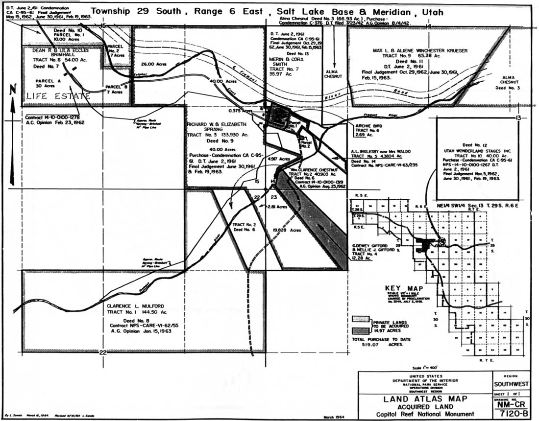
In June 1959, the survey of the Fremont River road was complete, but construction was delayed until the right-of-way through privately owned lands in Fruita could be obtained. [55] Delays in the appraisals of the inholdings would postpone construction for an additional two years. These delays were coupled with pressures from local and state officials and politicians to begin road construction. Hence, the National Park Service was pushed to initiate condemnation proceedings on tracts owned by Dean Brimhall, Max Krueger, Cora Smith, and Elizabeth Sprang. Right-of-way through 40 acres east of Fruita owned by the Campbell brother's Wonderland Stages was also required. Final condemnation of lands needed for the highway's right-of-way through Fruita was granted on June 2, 1961. Within one month, a $570,000 National Park Service contract for 5.73 miles of new road within Capitol Reef National Park was awarded to low bidder Whiting and Haymond Construction Company of Springville, Utah. Construction of the new route for Utah 24 began in August 1961 (Fig. 48). [56]
|
| Figure 48. Fruita inholdings and proposed highway route. (click on image for an enlargement in a new window) |
Despite the annual fall floods and other minor problems, road construction progressed through the rest of 1961. With construction more than half completed, work was suspended on Dec. 15 due to weather, to begin again the following February. On July 18, 1962, the Bureau of Public Roads accepted the new highway as satisfactorily complete. Capitol Reef Superintendent William T. Krueger estimated that the total cost of the road construction was $747,548.19, of which $677,548.19 were actual construction costs. Within one month, travel on the new highway had increased by more than 60 percent since the month before construction began. [57]
One reason for the increase in traffic on the new road was the larger number of visitors attracted by the new paved highway through the monument. Another reason was the fact that, once Utah 24 was paved all the way to Green River, this road became the shortest truck route between Los Angeles and Denver. Thus, prior to the late 1970s completion of Interstate 70 north of the park, semi-truck traffic through the heart of Capitol Reef was heavy. [58]
Perhaps the most noticeable resource alteration caused by the road's construction was near the current eastern boundary, where a cut was excavated to divert the Fremont River from its natural course. (In 1962, of course, the monument's eastern border along the Fremont River was west of this road cut, near the Behunin Cabin.) Rather than building the highway to follow the bend of an old riverbed meander, on property owned by Wonderland Stages, highway officials blasted directly through a soft sandstone cliff. Then, instead of building a bridge over the Fremont River and allowing the flow to continue along its natural course, they blasted out a new channel that cut off the meander and kept the river on the north side of the highway. The diversion takes the river on a new course over a small cliff, thereby creating a waterfall that has become a popular swimming hole for visitors and local youngsters. The old meander in wet seasons still holds water and provides habitat for a number of plant and animal species. Because this road cut and river re-channeling took place outside the monument, the National Park Service had no voice in the matter and apparently kept no records documenting this portion of Utah 24 construction. [59]
Scenic Drive
Once the new Utah Highway 24 was completed along the Fremont River, the old route through Capitol Gorge reverted to National Park Service control. As per the 1961 cooperative agreement and Capitol Reef's master plans, the road was closed off at the head of the Capitol Gorge narrows. The road from Capitol Gorge to Pleasant Creek remained open to vehicle traffic (Fig. 49). [60]

|
| Figure 49. 1962 Master Plan, monument roads and trails. (click on image for an enlargement in a new window) |
The increased traffic brought by the new highway led to a corresponding increase on the Scenic Drive as well. Approximately 40 percent of all visitors traveled at least part of this road, which was dirt south of Fruita. It was washboarded, rutted, and dusty most of the time, and the road turned to mud in the wet season. In July 1966, the National Park Service improved and graded Scenic Drive between Fruita and Capitol Gorge. Twelve new culverts helped solve the drainage problems. Superintendent Harry Linder considered the road to be "in excellent condition for visitor enjoyment with the exception of the dust which the summer rains should take care of." [61]
In 1969, Scenic Drive was scheduled to receive further attention, including chip-sealing the entire length from the campground to the mouth of Capitol Gorge. [62] However, the unexpected expansion of the national monument and all of its attendant worries evidently canceled that project, which would be revived in the spring of 1990.
Mission 66 Trails And Access Roads: 1956-1966
During 1955-56, various drafts of the Mission 66 Prospectus developed the initial philosophy toward new trails within the monument. A November 1955 draft stated:
As the area is difficult to access and due to the type of visitor, a large portion of the monument should always be reached by trails in preference to construction of roads. A note of caution, however, is necessary; we should not over-build on trails as they are very expensive to maintain in this country and changing patterns of use may mean too heavy a burden if trails buildings (sic) is overdone. [63]
This preference for trails over roads would become a predominant theme in Mission 66 development of the monument. The final, director-approved prospectus acknowledged that utility roads would have to be constructed to the new campground and possibly to Pleasant Creek. Nevertheless, trails would provide the primary access routes into the spectacular backcountry of the Waterpocket Fold. The prospectus continued:
Short trails to the natural bridges (sic) and some of the outlying canyons will be constructed to give safe access to hikers or horseback parties. These trails will be designed as to take visitors to vantage points. It is believed that at least one wilderness trail of low standard is justified to give access to the primitive area north of the Reef. This would enable those who wish to get into the true desert wilderness to do so with some effort. [64]
Trail mileage would significantly increase during the Mission 66 period from 1956 to 1966. In the 1956 estimates, only 8.6 miles of additional trails were planned. These included two miles added onto Broad Arch (Hickman Bridge) Trail, which would take visitors to Whiskey Spring and an overlook high above Fruita; 1.1 miles of trail into Cohab Canyon; and various walks and paths in the Fruita area. [65] Not listed were undeveloped trails along the bottom of Grand Wash and up to Cassidy Arch. [66]
By 1958, four miles of additional trails "to points of interest" were included in a revised development outline. [67] Then, in 1960, proposed total trail mileage in the monument was dramatically increased to 24.5 miles. This included seven miles of new construction and 17.5 miles of reconstruction or relocation. [68]
That same year, Superintendent Krueger raised the possibility that, since problems with purchasing the private inholdings needed for the new highway's right-of-way were delaying its construction, those funds could be shifted to trails and access roads. Krueger's first priority was the reconstruction and partial relocation of the Goosenecks Road, parking areas, and trail. Apparently, the road out to the goosenecks overlook had existed for some time, but there is no known documentation that gives an initial date for its construction.
As part of this same funding request in 1960, Krueger desired construction of the long-promised Whiskey Spring and rim overlook additions to the Hickman Bridge Trail, as well as rehabilitation of 1.9 miles of the Cohab Canyon Trail. Further trail work was also proposed for the previously unimproved routes to Cassidy Arch, Cohab Canyon spurs, through Pleasant Creek and up to the base of the Golden Throne. Unfortunately, no known record pinpoints exactly when these projects were initiated. [69]
The 1964 master plan drawings of established and proposed roads and trails show a total of 35.78 miles of trails within the monument. Which of these were improved trails, which were simply routes, and which trails were actually completed by 1964 is undetermined. [70]
Although trail construction records are sketchy, most trail building was apparently postponed until 1966. At that time, Superintendent Harry P. Linder reported, "The rehabilitation of the Cassidy Arch Trail was completed in July. This completes rehabilitation work on all but two trails which should be finished by end of summer. Everyone tells us the trails are in better shape than they have ever been." [71]
By October 1966, the Fremont River Trail was completed and work was begun on the Frying Pan Trail connecting Cohab Canyon with the Cassidy Arch Trail. [72]
By 1973, improved trails in the headquarters area of Capitol Reef National Park also included the three-mile Chimney Rock loop and a half-mile extension of the Fremont River Trail to the campground overlook. Unimproved routes included the narrows of Grand Wash and Capitol Gorge, along Pleasant Creek, out to Sunset Point off the Goosenecks access road, and through Spring Canyon to the north. Another traditional but unimproved route followed Sulphur Creek from the Chimney Rock parking area to the visitor center . [73]
Additional trails were built by Capitol Reef rangers during the late 1980s and early 1990s. These included an extension of the Rim Overlook Trail another two miles to Navajo Knobs, new trails to a high point above the Fremont River Gorge west of the visitor center, and a three-mile loop trail following parts of the old Grover wagon road (Fig. 50).

|
| Figure 50. Capitol Reef trails, 1994. (click on image for an enlargement in a new window) |
Development of new roads and trails in Capitol Reef National Monument was hindered by rugged terrain and isolation. Yet, miles of road and trail work were completed in the equally rugged Zion and Bryce Canyon National Parks from the 1930s through the 1960s, suggesting that isolation was the more important factor delaying construction at Capitol Reef.
When the long-promised highway was finally constructed, circulation patterns within the monument changed significantly. The new highway brought an increasing number of visitors. With additional money and staff, Capitol Reef slowly extended its trail system, thereby enticing visitors to spend more time in the canyons or hiking to scenic view points. Fortunately, planners for Mission 66 and later developments in Capitol Reef had anticipated increased visitation. As of 1994, the roads and trails in the headquarters area, except for the most popular routes up to Hickman Natural Bridge and in the narrows of Grand Wash and Capitol Gorge, remain relatively uncrowded.
Post-Park Roads And Trails
Roads And Trails In New Park Areas: 1971-1973
When Capitol Reef National Park was established in December 1971, its managers inherited 48.5 miles of county roads, 13 miles of former Bureau of Land Management roads, and approximately 32 miles of four-wheel drive roads. There were no additional trails aside from backcountry routes used by ranchers, their stock, or wilderness explorers. [74]
The county roads included 25.6 miles to the north of Utah 24 and 22.9 miles in the southern portion of the new park. These county-maintained roads included the Caineville Wash and Cathedral Valley roads built in the 1940s (the Upper Cathedral switchbacks were cut around 1949), and the Hartnet and Notom Roads. [75]
It is unclear which 13 miles were built with Bureau of Land Management funds. In the North District, according to rancher Garn Jeffery, the two rough access roads from his ranch (often called Baker Ranch) and the Oil Bench road down Rock Spring Bench were improved by the BLM during the mid-1940s. [76] Those who built the road from the river ford up the bentonite clay hills to the Hartnet road are not clearly identified. Ward Roylance claimed that this road was built by the BLM during the mid-1950s. [77] Rancher Guy Pace, on the other hand, recalls that Wayne County, with his help, built the road during the late 1940s and early 1950s. More research is needed to accurately determine the history of the roads in the outlying areas of the park. [78]
The four-wheel drive roads presumably included the 13 miles of jeep track following Halls Creek south of The Post, as well as several dead-end spur roads in the North and South Districts, used for mining and grazing access. The ranching access roads included the Lower South Desert Overlook (originally built into the South Desert in 1958 for oil exploration), Upper Cathedral Valley line shack and corral, Gypsum Sinkhole and Lower Cathedral Valley access roads in the north, and the Swap Canyon and Red Canyon roads in the south.
Mining access roads included a few small spur roads off the South Draw road from Pleasant Creek to Bowns Reservoir; the Rainy Day Mine road off the Burr Trail; a spur into North Coleman Canyon from a Sandy Ranch road accessing the Oak Creek dam and canal; four-wheel drive routes from Dixie National Forest into Oak Creek Canyon; the Terry Mines road near Bitter Creek Divide; the 1956 oil exploration road past Jailhouse Rock into Little Sand Flat; and a connecting road into the Upper South Desert built in 1959 by seismographers, presumably looking for oil. [79]
Congressional Testimony And Requirements
Immediately after President Lyndon Johnson's presidential proclamation in 1969 expanded Capitol Reef to over 250,000 acres, an immediate outcry of protest arose from the area's traditional multiple-use operators. [80] Since access to many areas of the Waterpocket Fold was limited to a few dirt roads, users feared that some roads might be closed. During the May 31, 1969 subcommittee hearings over the monument expansion, South Desert rancher and Wayne County Commissioner Guy Pace stated:
With the present trend to put all national parks into natural wilderness areas, additional restrictions are placed on use of the parks. Road development in the area stops, and frequently existing roads and trails are blocked within the boundaries of these areas, and recreational expansion stops. We have had the experience in the old Capitol Reef National Monument of having scenic roads in the monument blocked. Capitol Gorge and Grand Wash have been closed to vehicle travel. Only those who have the time and energy to hike considerable distance can now enjoy this part of the park. [81]
As Pace implied, there was particular concern that the monument's expansion would terminate future road development.
The National Park Service attempted to placate road development advocates while defending the agency's management philosophy. The inherent conflict between these two objectives is expressed in a 1971 draft environmental statement issued for in-service use by Southern Utah Group General Superintendent Karl Gilbert. According to Gilbert, Capitol Reef should attempt to limit visitation into the fragile backcountry while at the same time promoting road improvements. [82] The final environmental statement provided a few more specifics on how this incongruous need for both better roads and protected resources would be managed:
Additional park roads are not proposed; however, the upgrading of existing roads is proposed. Generally this will be of environmental benefit to the area. The present roads are low standard and have been rerouted here and there to meet erosion conditions. Drainage structures are nonexistent and crossings of washes have been relocated at the whim of the individual maintaining the road. Flash flooding is commonplace. Great care will be used in determining the final location of these roads and in designing the roads so as to minimize adverse environmental impacts. [83]
One reason for the delay in formulating a roads and trails policy was the agency's unfamiliarity with the outlying regions of the proposed park. This delay, coupled with local concerns over roads, convinced sponsors of both the Senate and House bills to include a clause requiring a detailed transportation study for the new park. In November 1971, the congressional conference committee, which ironed out the discrepancies between the Senate and House versions, recommended that the Department of the Interior have sole responsibility for this "comprehensive" study and that it be coordinated with the studies for other National Park Service areas in the same region. The conference report specified, "Because of its importance to the future of the communities involved, the report and the recommendations are required to be completed and transmitted to Congress within two years after the date of enactment." [84]
The Department of the Interior seemed to have no objections to this requirement, provided that adequate funding was available. [85] Thus, with no apparent opposition, the following wording was included in the final enabling legislation for Capitol Reef National Park signed into law by President Richard Nixon on Dec. 18, 1971:
The Secretary, in consultation with appropriate Federal departments and appropriate agencies of the State and its political subdivisions, shall conduct a study of proposed road alignments within and adjacent to the park. Such study shall consider what roads are appropriate and necessary for full utilization of the area for the purposes of this Act as well as to connect with roads of ingress and regress to the area. [86]
Similar wording was also included in the legislation creating Arches National Park and expanding Canyonlands National Park earlier in 1971. Notably, however, Glen Canyon National Recreation Area legislation was not passed until the following year and was therefore not formally involved in this particular road study.
Transportation study projections and analyses are often ignored in the political arena. By the 1970s, any road development in such a sensitive area as southern Utah was bound to lead to intense conflict that would be resolved either through compromise or court action. Thus, the only historical significance of such a transportation study would be contemporary listing of various options.
1973 Transportation Study
A professional services contract was issued to Environmental Associates of Salt Lake City, Utah to complete a joint transportation study for Arches, Canyonlands, and Capitol Reef National Parks and separate master plans for each. Unfortunately, no further documentation, such as a scope of work, has been found to indicate what the National Park Service wanted included in this study, how much money was authorized, or whether the project should be done in-house or under contract. Since the locations of Capitol Reef's records from the early 1970s are unknown, there is also no documentation of the park's and region's reactions to the joint transportation study when it was issued at the end of 1973. [87]
It is known that the recommendations concerning Capitol Reef National Park were never approved. Further, the 1973 master plan for Capitol Reef, prepared by the same consulting firm and including the same detailed transportation analysis, was rejected as unsatisfactory. [88]
In developing the joint transportation study and the separate master plans for each area, Environmental Associates evaluated existing and potential regional road systems and visitor services. In conjunction with the evaluations, the consultants also considered the various proposals submitted by the Utah State Department of Highways and various federal agencies, including the National Park Service. The purpose was to derive transportation management proposals that would enhance visitor experience, avoid congestion, maximize capitol investment, and minimize non-visitor traffic. The goal seems to have been to combine the various proposals into an acceptable compromise. [89]
The Utah State Department of Highways proposals were, naturally, the most far-reaching. Ever since the tourist potential of southern Utah was first realized in the early 1900s, state planners, often in cooperation with the National Park Service, had advocated building scenic highways through the rugged and beautiful terrain. By the 1970s, the state was pinning its hopes on a spectacular Lake Powell Parkway from Glen Canyon City through Canyonlands National Park and across Cataract Canyon to Moab. Other paved roads, some of which were of more immediate concern to Capitol Reef, would act as arteries to this highway through the heart of the Colorado Plateau. The new roads and upgrades proposed by the state included paving the Boulder-Bullfrog road and Utah Highway 12 over Boulder Mountain. The plan also called for rerouting and paving a road from Fremont Junction to Notom Road, which in turn would be paved all the way to Bullfrog Marina on Lake Powell. If any one of these roads was completed as planned, it would significantly change the volume and nature of visitation to Capitol Reef National Park. [90]
The consultants' recommendations, termed the "National Park Service Proposal," called for substantially less. According to the contractors, Capitol Reef managers should strive for the worthy but still contradictory goals of increased access and minimal visitor impact. Specifically, the joint transportation study recommended that the section of the Notom-Bullfrog road inside the park boundary be paved, that the Burr Trail be upgraded to an all-weather gravel road, and that the existing dirt road from Utah 24 north to Lower South Desert Overlook be widened and paved. [91]
In its 1973 master plan for Capitol Reef National Park, Environmental Associates recommended further road improvements. These included a new highway from Fremont Junction southeast to Hanksville, as an alternative to the Fremont Junction-Bullfrog paved road proposed by the state. Another was the possible paving of the entire Notom-Bullfrog Road and the Boulder-Bullfrog Road (except for the Burr Trail, which would be graveled). In the park's North District, a one-way, paved loop road should be constructed to follow the existing dirt roads from Utah 24, through Cathedral Valley, and then over the Hartnet. The plan also recommended that Scenic Drive be improved and paved, that additional trails be built in the Fruita area, and that the jeep track along Halls Creek be restricted to foot and horse traffic. [92]
Thus, only two years after Capitol Reef National Park was created, there was a wide range of ambitious proposals to improve the roads and trails in the newly expanded area. The plan proposed by Environmental Associates did achieve the goal of blending the various options into a compromise proposal. Yet, even if its recommendations were less than the state or counties desired, they were still too ambitious for the National Park Service -- especially since the park was so new, so little was known about its existing resources, and the political climate in southern Utah was so contentious.
Wilderness Constraints
In addition to the transportation study, Capitol Reef's enabling legislation required that a wilderness study of the new park be completed within three years. [93] Any extensive roadless wilderness within Capitol Reef would obviously restrict road construction or circulation changes proposed in the 1973 master plan and transportation studies. While the wilderness proposals took the transportation and master plans into consideration, there seems to have been no actual coordination between the National Park Service wilderness study and the privately contracted transportation and master plan.
In November 1974, after several preliminary proposals and public hearings, the National Park Service formally recommended that 179,815 acres of roadless wilderness be designated in Capitol Reef National Park. There were to be nine distinct wilderness units, each separated by a road or proposed utility corridor (Fig. 51). The recommendation specified:
No existing roads that are to remain or routes of proposed roads are included in the proposed wilderness. However, a number of old roads not needed for park use are included. There are also many vehicle tracks associated with mining or seismic exploration during the uranium boom of the 50s. While too numerous to show on maps, they also lie within the proposed wilderness. All of these are to be obliterated and the land restored to as natural an appearance as possible. [94]

|
| Figure 51. Proposed Wilderness, 1974. (click on image for an enlargement in a new window) |
Two other proposed roads in the vicinity of Lower Muley Twist Canyon were also rejected, due to their tremendous cost and potential resource destruction. These roads, routes Q and V on the 1974 Proposed Wilderness Map, were initially recommended as part of Glen Canyon National Recreation Area enabling legislation in 1974. They were summarily rejected in the Capitol Reef Wilderness Plan and were never seriously considered again. [95]
While a wilderness plan for Capitol Reef National Park has never been formally approved, it is the stated policy of the National Park Service to manage any proposed wilderness areas as if they were designated wilderness. Later additions in 1984 mean that management is now empowered to restrict road construction from the nine proposed wilderness areas that make up 90 percent of Capitol Reef National Park. [96]
Because of this policy, there have been only a few times when road machinery was used in the backcountry. In 1976, a bulldozer was illegally brought in to clear the Oak Creek stock driveway, and in 1986, Superintendent Robert Reynolds reluctantly allowed the reconstruction of two stock ponds in the South Desert area of the North District. [97] In reality, the wilderness recommendations have had more of an impact on roads and trails in Capitol Reef National Park than either the 1973 master plan or transportation study.
By the end of the 1970s, little road and trail building had occurred since the park's creation at the beginning of the decade. This was mostly because park-wide development plans were postponed until resource surveys were completed. [98] Meanwhile, the 1974 wilderness recommendations mandated that 75 percent of Capitol Reef National Park be managed as roadless wilderness. That stance prevented road-building and ensured gradual deterioration of many of the old grazing and mining jeep trails. By the early 1980s, however, preparation of the first general management plan for the park, right-of-way issues, and the growing Burr Trail controversy would push roads and trails management at Capitol Reef into a more active phase.
1982 General Management Plan Proposals
In October 1982, Capitol Reef National Park finally had a comprehensive, director-approved General Management Plan (GMP). [99] Because of their significance to park management, roads and trails were prominently featured in the 1982 GMP. Until a new general management plan is finished and approved sometime in 1998, the 1982 plan provides the operational guidelines by which Capitol Reef National Park manages its resources.
Overall, the 1982 plan instructed park managers to seek an active role in all future road developments. It stated:
It is not in the interest of the Park Service to finance improvements of the through-roads in the South and North districts during the lifetime of this plan. Should the county and/or state propose improvements in any of these roads, the Park Service will retain a voice in the design of these roads and in the regulation of traffic on them within the park to protect park lands, resources, and visitors. [100]
This statement meant that park managers would work with county and/or state road planners, but would retain the National Park Service's right to determine final road alignments, speed limits, vehicle size limitations, and permitted periods of use. [101]
The 1982 general management plan called for construction of one new road, the paving of another, and several new trails, all in anticipation of increased visitation. A total of five action or plan alternatives were considered during the planning process. What follows is a description of roads and trails existing in 1982, and a summary of the desired changes expressed in the general management plan. (See that document for a complete table of alternatives).
A. Headquarters District
Current Conditions. Utah 24 was still the only paved road through the park. Along this road there were 11 scenic pullouts, including the graveled Goosenecks/Panorama Point spur road constructed and maintained by the National Park Service. Scenic Drive was a paved, two-lane road to the campground, with a one-lane bridge over the Fremont River. South of the campground, the road became a two-lane gravel road to Capitol Gorge, where it then reverted to a graded dirt road. The road to Pleasant Creek was a narrow, graded dirt road. There was also the one-mile dirt spur road into Grand Wash, plus seven scenic pullouts. The entire Scenic Drive was owned and maintained by the National Park Service. [102] The South Draw jeep track that runs south of Pleasant Creek and continues on to Lower Bowns Reservoir in Dixie National Forest is not mentioned in the GMP.
There were approximately 16 miles of constructed or marked trails in the Headquarters District. These included maintained trails to Hickman Bridge, Chimney Rock, Goosenecks, Cassidy Arch, along the Fremont River, and up to the base of the Golden Throne. Other routes, such as those along the bottom of Grand Wash and Capitol Gorge, were unmaintained routes. Some, such as like the Frying Pan Trail, were marked by rock cairns. [103]
Preferred changes to Headquarters District. The only proposed change was to widen and pave spur road out to the Goosenecks Overlook at a cost of $228,000. Alternative 3 had also proposed spending almost $6 million to pave the Scenic Drive as far as Pleasant Creek, but the preferred alternative would keep the Scenic Drive gravel. [104]
The only new trail proposed was a two-mile loop through the historic Fruita area, connecting the campground with the picnic area, orchards, schoolhouse, Hickman Bridge trailhead, and visitor center. It was also proposed that trailhead parking be added at Pleasant Creek to encourage use of the canyon route, as well as more backcountry use in general by backpackers and equestrians.
B. South District
Existing Conditions. The only South District roads mentioned in the GMP are the Notom and Burr Trail roads, which intersect near The Post, and an unmaintained four-wheel drive road up Upper Muley Twist Canyon to the Strike Valley viewpoint trailhead. The Burr Trail and lower section of the Notom Road were maintained by Garfield County; the portion of the Notom Road north of the county line was maintained by Wayne County. Other known roads, such as the Halls Creek jeep road and the Rainy Day, Terry, and North Coleman Canyon mine access roads were not mentioned, most likely because they were considered permanently closed. All trails in the south district were unmaintained, backcountry routes. [105]
Preferred Changes. No major alterations were seen for the Notom Road. It was proposed that small, five-car parking areas be added at Burro, Cottonwood, and Five-Mile washes and Sheets Gulch. While it was assumed that some change would occur to the Burr Trail, no specific alternatives were considered in the GMP. According to the general management plan, the anticipated increase in visitation resulting from the road's improvement might necessitate construction of a permanent contact station, employee housing, and a primitive, expandable campground at the foot of the Burr Trail switchbacks. [106]
The only new road proposed anywhere in the park would change the access to Strike Valley Overlook. The plan recommended that the old road through Upper Muley Twist be turned into a foot trail, and that a new, 2.5-mile gravel road be constructed from a point further west on the Burr Trail to a 15-car parking area at the Strike Valley trailhead. Gravel would also be applied to the rough, often impassable road over Bureau of Land Management land out to the Brimhall Bridge/Halls Creek Overlook Trail. New trails in the South District would be built at Bitter Creek Divide, with a spur trail to the Oyster Shell Reef. [107]
It should be emphasized that all these improvements were contingent on road improvements and the corresponding increase in visitation. Until the roads were upgraded, the NPS preferred that little change occur in the South District of Capitol Reef.
C. North District
Existing Conditions. The two main access roads into the North District were the Caineville Wash and Hartnet roads. Both were graded dirt, maintained by Wayne County. Like the roads in the South District, they were considered impassable when wet, but the North District roads were much rougher and passable only to high clearance two-wheel or four-wheel drive vehicles. Short spur roads led from the Hartnet road to Lower South Desert Overlook, the Upper South Desert Viewpoint, and the Cathedral Valley Viewpoint. Spurs off Caineville Wash Road led to lower Cathedral Valley and the Temples of the Sun and Moon. It is assumed that these roads were also maintained by the county. The access roads up to Fremont Junction to the north or over Thousand Lake Mountain to the west are also mentioned. [108] By 1982, the former roads into the South Desert were closed and off-road vehicle use was prohibited.
Preferred Changes. Unlike the 1973 master plan proposals, no new development or road improvements were sought for the North District. Visitor access would be limited to the existing roads and hiking routes from Lower South Desert Overlook to Jailhouse Rock, from the Hartnet Road out to Middle Desert Viewpoint and the Lower Cathedral Valley Overlook. An additional trail was planned around the Wall of Jericho in Upper Cathedral Valley.
1994 Conditions
The 1982 Capitol Reef General Management Plan called for few significant changes in terms of roads or trails. The new Strike Valley access was the only new road planned, and only the short Goosenecks access was recommended to be paved. New trails would be limited to increasing the marked backcountry routes and creating a new, two-mile loop trail through Fruita.
Since 1982, little has changed in the still-isolated backcountry areas of Capitol Reef National Park. There are a few widened trailhead parking areas and improved trail markings in Upper and Lower Muley Twist Canyons in the South District. There is also a new dirt access road into the Oak Creek trailhead, necessitated by complaints from Sandy Ranch that the old access road crossed its property. [109]
In the north, a new trail was constructed by former Backcountry Ranger Larry Vensel out to the Wall of Jericho in Cathedral Valley. There are have been no other significant changes to the North District's roads or trails.
While Scenic Drive was paved in 1987 as far as Capitol Gorge, the Goosenecks Road is still gravel. New trails to Navajo Knobs and the wagon road loop and better access to Spring Canyon have increased trail variety in the headquarters area. Rangers have also marked a new trail from the highway across from the visitor center going up behind the "castle" formation. Surprisingly, after a steady increase during the early 1980s, backcountry use in the park has remained relatively stable during the 1990s.
The History Of The Boulder-Bullfrog
Road
The 66-mile-long Boulder-to-Bullfrog Road that crosses the southern part of Capitol Reef National Park has developed into one of the most controversial roads issues in recent history. Because of the spectacular switchbacks named for rancher John A. Burr, the entire road is commonly called the Burr Trail. This road has had more of an impact on the contemporary management of Capitol Reef National Park than any other, with the possible exception of Utah Highway 24.
The following summary history of the Boulder-to-Bullfrog Road was taken from the author's "Boulder-Bullfrog Road: Comparison of Sections Before and After 1942," which was later abbreviated and included in the 1993 "Environmental Assessment for Road Improvement Alternatives, Boulder-to-Bullfrog (Burr Trail)" (see Fig. 46). [110]
Section 1 - Boulder To Capitol Reef National Park:
1880-1942
Until 1942, the main reason anyone ever went east from Boulder to the Circle Cliffs was to trail livestock. Given the lack of motorized transportation in eastern Garfield County, it is easy to understand why there was no road on the stretch from Boulder to what is now Capitol Reef National Park until after World War II.
According to Garfield County ranchers, a well-used cattle trail went east- southeast from Boulder across Deer Creek, into The Gulch, and then through Long Canyon and onto the flats at the base of the Circle Cliffs. This trail probably looked similar to other cattle trails in the area, varying in width according to the terrain. If the livestock were being driven over the more wide open benches of pinyon and juniper vegetation, the trail could have been over 50 yards wide in places. When the trail descended steep sandstone ledges toward canyons, such as Deer Creek and The Gulch, the animals would line up and move single file. [111]
Unfortunately, it is impossible to document exactly where the cattle trails lay in relation to modern roads. Places where some of the trails descended into canyons are still visible today. But in more vegetated areas and in flood-cleansed wash bottoms, there is little to follow. Therefore, it is unclear if the road from Boulder to Long Canyon follows the exact alignment of a traditional cow trail.
It is known, however, that the Boulder to Long Canyon route was not the preferred livestock driveway by the early 1930s. Instead, the route agreed upon by cattle ranchers "follow[ed] the road through Boulder thence down through Draw east of Durfey Bench to Deer Creek, Cross Steep Creek Bench to Steep Creek, down [S]teep Creek to the Gulch and on to Egg Box Canyon." [112] This route was improved in 1935-36 by the new Grazing Services and Emergency Relief Administration, in cooperation with affected ranchers. Wagons of supplies and tools could get up The Gulch and out Egg Box Canyon to the improved Brinkerhoff Spring and other water holes at the northern end of the Circle Cliffs by this route. [113]
In either 1935 or 1937, a crude wagon road was blazed up Long Canyon's wash bed and out into the Circle Cliffs basin as far as Horse Canyon. Wagons and horse or mule teams pulling dirt scrapers were used to make the boulder-strewn wash bed accessible by wagon. It is unclear what the road looked like between Long and Horse Canyons, but the switchbacks on the 1953 United States Geological Survey (USGS) topographic quad map and the current alignment are definitely different. [114]
Significantly, no county road east of Boulder is in evidence on the official Garfield County road map of 1938. Thus, the wagon road east from Boulder through Long Canyon must have been extremely rough and seldom used. [115]
By 1942, the section of the Boulder-Bullfrog Road east from Boulder to Capitol Reef National Park included a wagon road, in approximately the same alignment as today, southeast from Boulder across Steep Creek Bench. Here, one either descended Steep Creek or went south into The Gulch at its junction with Long Canyon. Once in the canyon bottom, a crude wagon road followed the canyon wash bed up to the head of Long Canyon and descended to Horse Canyon, where the road stopped. This road, like the trails before, was still used primarily for moving livestock. There is no evidence of anything but livestock trails across the Circle Cliffs basin along today's park boundary.
Nor is it clear if any livestock trail followed close to the Boulder-Bullfrog Road's present alignment. What is clear is that the route through Long Canyon was only one of many into the Circle Cliffs. [116]
Section 1: Post-1942
After World War II, BLM range improvements and the uranium mining boom caused additional work on this section of the Boulder-Bullfrog Road. Improvements were made to the wagon and, later, jeep road in 1947 and 1950. Yet, the road continued in the bottom of Long Canyon.
The 1951 Garfield County road map is, unfortunately, not very detailed, but it does indicate that the road out of Long Canyon had not yet progressed much past Horse Canyon by the end of 1950. The road appears to be in roughly the same alignment as it travels southeast from Boulder, across Deer Creek, and up onto Steep Creek Bench. An additional switchback into The Gulch is indicated on the 1951 map, that is not shown on the 1964 U.S. Geological Survey (USGS) quad. On the 1951 Garfield County map, no drainage is indicated as Long Canyon. Nevertheless, the 1951 map and a 1953 USGS quad map both show a road following the same general direction out of Long Canyon, crossing Horse Canyon, branching, and then ending. Evidently, as of 1951 there was still no connection with either the Silver Falls-Lampstand Road, which runs north/south through the heart of the Circle Cliffs, or with the Burr Trail to the east. [117]
The 1953 USGS topographic maps of the area compiled from aerial photos taken a year earlier show a four-wheel drive road all the way from Boulder, through Long Canyon and across the Circle Cliffs to the present western park boundary. This road would be used throughout the 1950s by stockmen driving cattle, by hundreds of uranium miners and their ore trucks, and by a few tourists, too.
Further improvements and realignments of the road were made from 1961-72. These included a new dugway down into The Gulch, partial realignment of the road through Long Canyon and into the Circle Cliffs, and a new cut-off near the Lampstand Road. [118]
The road remained essentially unchanged from 1976 to 1988, except for minor improvements and maintenance. From 1988-91, major development of the road included improving the stretch into The Gulch, and general widening, realigning, and chip sealing of the 26 miles between Boulder and Capitol Reef's western boundary. A new bridge was built over Horse Canyon, but the wash crossings over Deer Creek and The Gulch were only slightly improved.
By 1995, the section of the Boulder-Bullfrog Road from Boulder to Capitol Reef was quite different from the rough wagon road of 50 years earlier. The significant changes in alignment are documented above. It is the traveler's experience, however, that has really changed. The winding, narrow dirt road that took the adventurous traveler through the incomparable beauty and isolation of the Circle Cliffs region has become a smooth, curving highway accessible by any type of vehicle.
Section 2 - Western Capitol Reef Boundary To Eggnog
Junction: 1880-1942
The steep, 600-foot slickrock and scree slope on which the Burr Trail road is located is the only relatively easy crossing over the entire southern Waterpocket Fold. The route was probably used initially by American Indians, but was later improved by sheep and horse ranchers to allow their livestock to move between summer and winter ranges. The narrow, precarious livestock trail probably began in the Burr Canyon wash bottom to the east of the slope and then started up the north side before beginning to switchback across the slope to the rim above. [119]
Once at the top, herds were driven in many directions within the Circle Cliffs. Sheep were driven to the north, up around the Lampstand and Corner Flats. Though documentation is absent, this livestock trail probably went through the Studhorse Peaks, just as the modern road does. This is the most likely route because the cliffline to the north and east of the Studhorse Peaks would have prevented travel in those directions. Any other route would have meant a lengthy detour to the south and west before looping back around toward the Lampstand. [120]
Less than a mile from the bottom of the switchbacks, the trail along the wash bottom would have intersected with the Notom supply road coming from Capitol Gorge and down the eastern side of the Waterpocket Fold. [121] This supply road was used by wagons since the 1880s to bring food, water, and other necessities to those tending livestock in the Circle Cliffs and Henry Mountains. Supplies were left in large, wooden storage boxes located near The Post, about two miles south of the Burr Canyon Wash-Notom Road Junction. Herders in the Circle Cliffs would go down the Burr Trail switchbacks to The Post, load up their pack mules with supplies, visit with others there for the same purpose, and then head back up the trail. [122]
The Notom Road continued past The Post, cut between two ridges to the east (passing the modern Capitol Reef boundary in one mile), and then went south-southeast for another seven miles to the present Eggnog Junction. From there, the old wagon supply road headed east and up unto the base of Mt. Hillers in the Henry Mountains.
This section of the Boulder-Bullfrog Road did not change much from 1880 to 1942. There is no recorded evidence of road or trail improvements along this stretch during that time. The physical description of the road is substantiated by two maps. The topographic map of the Henry Mountains region surveyed between 1935 and 1939 clearly shows the Notom supply road -- almost identical to its present alignment -- as a double-dashed line going south past The Post and continuing on past today's Eggnog Junction. The Burr Trail is clearly labeled and marked as a switchback trail ending at the top of the Fold. There are no indications of trails continuing to the west from the top of those switchbacks. [123]
The September 1939 map of Henry Mountain and Boulder Unit, Utah Grazing District No. 5 also represents the Notom Road with a double-dashed line road south from Notom. The Burr Trail is also labeled and represented by a straight, double-dashed line due west for about one mile before stopping. This map does not indicate switchbacks on the Burr Trail or the part of the road heading off toward Eggnog Junction. [124]
From 1880 to 1942, the physical characteristics and use of the Burr Trail switchbacks and section of the Notom road from Burr Canyon past The Post to Eggnog Junction did not change. There are two likely reasons why a wagon road was not cut up the Burr Trail. First, the slope was too steep to cut a road into with the roadbuilding technology available at the time. Second, a wagon road was already available through the rough, seldom-used, Halls Crossing route through the southern end of Muley Twist Canyon. [125]
Section 2: 1942 To Present
The most significant alteration to the Burr Trail occurred in 1948 when the Atomic Energy Commission brought in a caterpillar tractor to cut a crude road up the Burr Trail switchbacks, improving access to uranium claims within the Circle Cliffs. [126] It is still unclear whether this new "road" followed the old livestock trail up the switchbacks or how far west of the switchbacks this road continued when it reached the top. It is most likely that at this time the route was diverted from the Burr Canyon wash bed onto the southern bench.
At the base of the steep slope, it appears the tractor began at the north side (exactly where the trail began) and then cut immediately back to the south to create the first switchback. A small section of what maybe the old trail is still visible, climbing some yellow tinted sandstone on the north side between this first and second switchback. If so, it is the only visible remains of the old trail.
Once on top, the 1948 road most likely followed the Muley Twist wash bottom just as the present road does, since there is no physical evidence of any other road. The original route after the road leaves Muley Twist Wash is undetermined. According to the 1953 Wagon Box Mesa topographic map, the route (still marked as a single dashed line signifying a simple pack trail) follows a side wash coming in from the west. But close examination of this presumed route shows no clear evidence of any roads except ones leading south to the Rainy Day mines. Since this road would have been used extensively by miners and ore trucks by 1952 (when the aerial photos for the USGS map were taken), and since there is no evidence of major road improvements until the 1960s, the road should still be visible where it followed and crossed this drainage. Therefore, either the map is wrong or the road was not built west of the Burr Trail until after 1952. [127]
From the west end of the state section (T34S R8E S16) for the last two miles to the western Capitol Reef boundary, the road appears in the same alignment on the 1953 and 1964 USGS maps. During that time, cartographers upgraded the road symbol from double-dashed lines to continuous double lines representing a graded dirt road. Today, travelers may notice a wide corridor cleared of trees or large shrubs along both sides of the road. This was probably created in 1967 when the Burr Trail switchbacks and other sections of the Boulder-Bullfrog Road were widened and improved. [128]
The Burr Trail road was extensively used by uranium miners and their ore trucks throughout the 1950s and into the 1960s. Even though the road must have been rough, most likely requiring four-wheel drive, miners would have used the Burr Trail to get to their claims because it was quicker and easier access than coming in from the west through Long or Silver Falls Canyons. Loaded ore trucks would descend the Burr Trail, bound for the refinery at Moab. Families of the miners used the Burr Trail to visit relatives at the mines, often staying at barracks provided by the uranium mine company. A few tourists also used the Burr Trail to take pictures or view the petrified wood deposits within the Circle Cliffs. The new, primitive road that followed the old Burr Trail livestock driveway was now more heavily used, and used for more purposes, than ever before. [129]
In 1967, as mentioned above, the Burr Trail switchbacks and access roads were widened and improved. This was done as part of the same project that constructed the new road from Eggnog Junction to Bullfrog, and the paved highway from Hanksville to the future site of Bullfrog Marina on Lake Powell. According to Project Engineer Ted Christensen, the curves and sides of the switchbacks were widened and renovated to minimize the slumping that occurred during wet weather. Yet, Christensen also learned that too much widening would also cause the road to slump, because the clay soil base made a poor road bed. [130]
These projects were funded by the federal Economic Development Administration. Under a cooperative agreement with the Utah State Highway Commission, Garfield Country was to assume all maintenance responsibilities for the completed road. [131] These later improvements made little change to the road's alignment through the present park boundaries. However, Capitol Reef National Monument would not be expanded to include the Burr Trail for another year and a half. [132]
Sections 3 And 4 - Eggnog Junction To Utah State Highway
276: 1880-1942
There is no evidence of any historic trail or road in the vicinity of this section of the road. The dry benches and impassable, cliff-lined canyons draining into the Colorado River forced early livestock and supply trails to veer east, close to the base of Mt. Hillers.
Sections 3 And 4 - 1942 To The Present
This section of the Boulder-Bullfrog Road was built over previously roadless land in 1967, under a grant from the federal Economic Development Administration. It was part of the larger project to bring roads into the newly developed Bullfrog Marina on Lake Powell. The road was a totally new alignment, except where it crossed an occasional old range improvement and oil drilling road (built in the late 1940s or early 1950s). A large fill bank was constructed to enable the road to descend off the steep-walled Middle Point, and switchbacks were cut down into Bullfrog Canyon wash. From there, the road went then east to a junction with Utah 276. The road now passes through Glen Canyon National Recreation Area. On either side of the recreation area, the road has been extensively widened and either paved or chip-sealed. [133] Except for the rough, dirt portion of the road in Glen Canyon National Recreation Area, this section of the Boulder-Bullfrog feels and looks like the modern road it is.
The new Boulder-Bullfrog Road is a recent phenomenon compiled from a myriad of roads and trails that have criss-crossed the rugged Waterpocket Fold country since the 1880s. Rugged terrain and minimum use by ranchers and miners had left the area free from improved roads well into the 1960s. Then, the hurried designation of large National Park Service areas at Capitol Reef and Glen Canyon National Recreation Area, coupled with the popularity of the Circle Cliffs and Escalante wilderness areas, led to a new focus toward tourism and recreational development. To capitalize on this popularity and stimulate economic development, Garfield County desired to pave the entire Boulder-Bullfrog Road.
On Aug. 16, 1968, state and county officials gathered to dedicate the newly constructed Utah 276 from Hanksville to Bullfrog and its Boulder-Bullfrog connection. The purpose of these new roads through the region is exemplified in the opening remarks of the master of ceremonies, Weston E. Hamilton:
We want to welcome you to the dedication of what we think is one of the most important road programs in the State of Utah. This is the type of program that we enjoy and appreciate. It does two things. It opens up an area for a better economic program and living for people who live in this area, but it also opens up a new part of our state that has been locked in for residents of the State of Utah and the country. [134]
Such occasions as the dedication of a new road -- or national park -- can stimulate the optimistic nature of boosters who promote tourist development. Yet, not even the most pessimistic person at that 1968 ceremony could have anticipated the convoluted path the Boulder-Bullfrog Road was about to blaze through the courts, congress, and the media.
The Modern Burr Trail
Controversy
Over the past few decades, many local, state, and federal officials have expressed the desire to open up the isolated wilderness areas of the Waterpocket Fold country to multiple-use management. Countering these demands have been persistent, assertive conservation groups determined to keep the roads primitive and the backcountry isolated. These pressures have increased substantially since the rapid expansion of National Park Service areas in southern Utah, the enormous rise in visitation to Lake Powell, and the growing tendency by both sides to confront rather than compromise.
The Boulder-Bullfrog Road has been the subject of a constant stream of suits, counter-suits, federal court and Interior Board of Land Appeals decisions, and congressional investigations and appropriation bills. While the majority of the attention has focused on the BLM section from Boulder to the western park boundary, uncertainty over the resolution of the disagreement has kept the National Park Service in a state of planning limbo.
Rather than detailing the tangle of court decisions and political posturing during the recent history of the Boulder-Bullfrog Road, this next segment summarizes the story with an emphasis on the National Park Service position throughout the dispute. [135]
Burr Trail Controversy: 1969-1991
During the late 1960s, the ambitious plans of the Utah State Department of Highways to build an elaborate network of paved roads throughout the Colorado Plateau were not enthusiastically received by the National Park Service. Concerned that new or upgraded roads would harm resources and overburden agency facilities and personnel, the National Park Service took the position that only modest road improvements should be encouraged in the new national parks and recreation areas of southern Utah. The differences between the state and National Park Service positions are easily seen in the summary proposals found in the various transportation studies and environmental assessments from the early 1970s to the 1990s. [136]
Conservation groups were even more adamantly opposed to the state's road plans. In fact, some joined the National Park Service in offering to accept the paving of the entire Boulder-to-Bullfrog Road as an alternative to building an entirely new highway (the previously mentioned Lake Powell Parkway) across the southern end of the Waterpocket Fold from Glen Canyon City to Bullfrog Marina. [137]
Once it was obvious that Congress would not fund the more ambitious road plans, state and county officials decided to improve already existing roads. In the Waterpocket Fold country, these included Utah 12 over Boulder Mountain and the Garfield County road from Boulder to Bullfrog Basin. Paving the Boulder-to-Bullfrog Road had always been the intent of the county and state planners, but initial funding had proven inadequate. [138]
Even the National Park Service was resigned to seeing some kind of improvement to the Burr Trail through Capitol Reef. The 1979 Task Directive for a new general management plan called for development of alternatives for road development and improvements within the park, planned in coordination with state, county, and other federal agencies. [139] Likewise, the 1982 Capitol Reef general management plan detailed development plans for a ranger/contact station, personnel housing area, visitor campground, and a new road to Strike Valley Overlook, all on the assumption that the Boulder-Bullfrog Road would be improved and would attract more visitors to the area. [140]
In early 1983, probably at the request of Garfield County officials, Utah Senators Jake Garn and Orrin Hatch proposed a $600,000 feasibility study for paving the road and creating a 69-mile-long "Burr Trail Highway." [141] Predictably, local environmental organizations responded with outrage, setting the stage for the conflicts that followed.
According to then-Chief Ranger Richard Newgren, the National Park Service took no initial position on the Burr Trail improvement. However, in a Salt Lake Tribune report, Newgren stated, "We're expecting that eventually the roads in the south end of the park will be improved and we're making plans to accommodate it." [142]
This reluctant acceptance of a Boulder-Bullfrog Road upgrade would eventually enable National Park Service officials to approach Garfield County with a minimum-improvement compromise. Yet, throughout most of the 1980s, bitter confrontations between those favoring and those opposing Burr Trail improvements made it virtually impossible for a National Park Service-sponsored compromise to succeed.
By 1984, the proponents of paving the Boulder-Bullfrog Road had refined their position with an engineering study completed by the St. George, Utah, firm of Creamer and Noble. [143] In an accompanying letter, signed by retiring Democratic Governor Scott Matheson and the five Republican members of the Utah congressional delegation, the paving of the Boulder-Bullfrog Road was promoted as an "essentially non-commercial scenic road that emphasized numerous scenic overlooks into southern Utah's spectacular Canyon Country." The letter added, "Construction of the scenic road and ferry boat system [across Lake Powell] will open southern Utah to maximize the potential for an optimum scenic tourist experience." [144]
The Creamer and Noble report was a detailed examination of various alternatives for paving the Burr Trail. The most dramatic called for elimination of the switchbacks, which would be replaced by an enormous, sloped embankment down the Waterpocket Fold. The artist's rendering of this alternative must have only hardened the conservation community's determination to fight. [145]
The $21 million alternative actually recommended by Creamer and Noble was much less destructive. Later to become the foundation of future Garfield County proposals, this plan called for paving the entire road along most of its existing alignment. Dramatic changes would be made only where the road crossed or followed wash beds, or traversed steep switchbacks such as those on the Burr Trail. As was to be expected, project opponents, led by the Sierra Club and National Parks and Conservation Association (NPCA), criticized not only the plan, but the report itself. NPCA Rocky Mountain Region Coordinator Terri Martin called the $75,000 Creamer and Noble study "a slick advertising job which glosses over the economic and environmental imprudence of paving the Burr Trail." It was, she declared, "designed to sell the paving project, not to study it." [146]
One of the arguments environmental groups used in opposing the Boulder-Bullfrog Road upgrade was that tourist travel would be diverted from Capitol Reef's headquarters area in Wayne County. The Wayne County Chamber of Commerce also expressed concern that the tourism business would be diverted south. But in the end, Wayne County residents favored paving the entire road, in hopes of obtaining a few road improvements of their own. [147]
Throughout 1985, the battle lines became entrenched. The Utah State Legislature approved a $600,000 initial appropriation to get road work underway, provided it was matched by federal highway funds. But the environmentalist leanings of Rep. Bruce F. Vento (D-Minnesota), chairman of the House Interior Subcommittee on National Parks, and Sidney Yates (D-Illinois), chairman of the House Interior Subcommittee on Appropriations, made approval of federal matching funds unlikely. Despite public hearings in southern Utah that resoundingly favored paving the entire road, and despite the strong efforts of the Utah congressional delegation, environmental lobbyists successfully delayed any funding from Congress.
While this issue has commonly been regarded as an environmental/development dispute, it certainly did not help the developers' cause that the Utah delegation was Republican in a Democrat-controlled Congress. [148]
Congress did, however, attach wording to the FY 1985 Interior Appropriations Bill requiring the National Park Service and Bureau of Land Management to complete an environmental assessment of the proposed changes to the Boulder-Bullfrog Road. [149] After investigations and initial public hearings, an initial assessment was released in May 1985. This assessment listed four alternatives:
paving the entire length of the Boulder-Bullfrog Road;
improving the road with gravel instead of pavement;
limiting improvements to make it passable to two-wheel drive vehicles except in the worst conditions; and
a no-action alternative, which would leave the road as it was. [150]
But with so much national attention being directed toward the Burr Trail controversy, National Park Service Director William Penn Mott decided to postpone official release of the environmental assessment's evaluation to Congress until he personally visited the area. [151]
Once Mott's personal inspection and consultations were completed, the director announced a compromise intended to help satisfy both sides and improve the National Park Service's stature in the area. His solution was to pave the most dangerous switchbacks, realign a section along the eastern boundary of Capitol Reef, and pave wash crossings. Mott also would put a new bridge across Bullfrog Creek within Glen Canyon National Recreation Area, gravel the rest of the road so it would become all-weather passable, and construct an interpretive center in Boulder. Finally, he proposed that the entire 66-mile road be declared a national "rural scenic road" to be administered by the National Park Service. [152]
Both sides of the dispute, at least initially, were cautiously receptive to Mott's proposal. While the paving proponents were disappointed, they saw the National Park Service plan as a constructive alternative. The National Parks and Conservation Association (NPCA) was willing to approve the plan so long as paving and realignment were kept to an absolute minimum. [153]
At first it seemed that the compromise would succeed. Congress passed P.L. 95-290,which appropriated $8.1 million for a "Burr Trail National Scenic Road" but failed to include authorization language. The Utah delegation countered this move by passing a continuing resolution allowing the money to be carried over into the following year. Urged by environmental lobbyists, Rep. Yates made sure that there was no wording in this resolution that would enable the money to be spent without further congressional approval. In other words, the $8.1 million could not be authorized until full House and Senate hearings and debate occurred. Since it would be virtually impossible to gain approval from the environmentally friendly, Democrat-controlled House committees, the $8.1 million, and thus Mott's compromise proposal, were doomed. [154]
Throughout 1986, Garfield County continued its attempts to get road improvement funding from both Congress and the Utah State Legislature. While supporters were initially hopeful, they soon realized that the initial Creamer and Noble plans would have to be scaled back in response to political and fiscal reality. Meanwhile, the National Park Service continued to support Director Mott's minimum improvement alternative. [155]
By early 1987, Garfield County determined that it could not longer wait for the long-promised funding. It decided to use $2 million of Community Impact Board funds to pave the first 28 miles from Boulder to the western boundary of Capitol Reef National Park. A formal construction bid was accepted, but before construction could begin, environmental groups led by NPCA, Sierra Club, and Southern Utah Wilderness Alliance filed suit in federal court to stop any improvements to the Boulder-Bullfrog Road. [156]
After two years of court battles in district and appellate courts and in the Interior Board of Land Appeals, Garfield County gained an adjudicated right-of-way, essentially winning the right to improve the Boulder-Bullfrog Road. The county soon initiated its plans to upgrade, realign in places, and put a double chipseal coating on two sections of the Boulder Bullfrog Road. By spring of 1991, the road was paved from Boulder to the western park boundary and from Eggnog Junction south to the boundary of Glen Canyon National Recreation Area.
State Section 16
Throughout the complex trial and appeals process, the National Park Service remained passively hopeful that a compromise could be worked out to allow for minimal improvements. Then, in December 1987, a land swap between the State of Utah and Garfield County gave the county title to T34S R8E S16, a state school trust section initially set aside for the state to help fund public schools. This particular section included the Burr Trail switchbacks. [157]
The deal, according to Garfield County Commissioner Tom Hatch, was conceived in mid-1987 as leverage in the effort to release the long-promised money from Congress. At first, he considered the land-swap possibility "almost as a joke." "Then," he said, "we began to take a serious look at our 'joke' and give it a try." [158] To the National Park Service and conservationists, this land-swap was no joke. In August 1987, Acting Regional Director Homer L. Rouse formally protested the initial application by Garfield County to assume control over the state section within Capitol Reef National Park. Utah Governor Norman H. Bangerter responded that he appreciated the National Park Service's concern that the county may adversely develop the land. However, the governor maintained that the state's responsibility was to obtain revenues from the state sections, no matter what the "opportunity costs" may be. [159]
The NPCA took immediate formal action to prevent the state section transfer by successfully filing a "petition for review" with the Utah State Supreme Court. NPCA argued that, regardless of the state's desire for school section revenue, there must be "consideration to federal and state law assuring the protection of the unique treasures protected in our national parks." [160]
During 1993, with the Utah Supreme Court injunction still in place, negotiations were undertaken by the National Park Service to transfer Section 16 to federal ownership. After negotiations between Superintendent Charles V. Lundy, NPS Utah Coordinator Martin Ott, and representatives from the state, Garfield County, and NPCA, the following scenario was tentatively approved:
Garfield Country would willingly sell or transfer Section 16 to the National Park Service.
In return, NPCA would withdraw its objections in the Utah Supreme Court.
This sale or transfer would not serve as a precedent for the statewide transfer of school sections within National Park Service lands then under negotiations. [161]
As of the beginning of 1998, the status of Section 16 has not been resolved. It is likely that a resolution to this issue will not be possible until an agreement is reached to transfer the rest of the school sections throughout Utah's National Park Service lands, and the Burr Trail dispute is resolved. Meanwhile, the Utah State Supreme Court injunction is still in effect, thus preventing unilateral development of the Burr Trail switchbacks beyond regular road maintenance. [162]
Burr Trail Compromise? 1992-1994
Once Garfield County had finished improving the sections to the west and east of Capitol Reef National Park, county officials notified the National Park Service that they were now interested in upgrading the sections of the Boulder-Bullfrog Road within Capitol Reef and Glen Canyon National Recreation Area. [163] Per the requirements of the National Environmental Policy Act (NEPA), the National Park Service, in cooperation with the Bureau of the Land Management, began researching and writing an environmental assessment for the entire 66-mile road. The purpose of this environmental assessment, released in March 1993, was to evaluate the various alternatives based on Garfield County's adjudicated right-of-way, and the impacts the alternatives would have on the natural, cultural, and socioeconomic resources of the region. [164]
Garfield County's proposal had not changed much since the 1984 Creamer-Noble report, except for some scaled-down options based on the reality that federal money would be difficult to obtain. Garfield County desired a 28-foot wide, paved road that would allow varying speeds from 20 to 40 miles per hour. In the Capitol Reef section, the plan called for widening and improving the existing road bed, graveling the entire length until funds could be approved for its eventual paving. Either one or two bridges would be built over Muley Twist Wash at the top of the Burr Trail switchbacks. The switchbacks themselves would be excavated and widened to accommodate all-weather travel for two passing cars. To the east of the Burr Trail-Notom Road intersection, a 6,000-foot section that Director Mott had agreed to realign in 1985 would either be improved or redirected onto firmer ground. [165]
The National Park Service, on the other hand, advocated a limited-improvement proposal designed by Superintendent Lundy. Lundy's plan was in several ways similar to Mott's 1985 plan. The superintendent called for a 26- to 28-foot gravel road with the minimum amount of culverts, excavation, and drainage work required to meet the criteria for a safe, all-weather road. The two remaining alternatives in the 1993 environmental assessment called for either more restrictions on improvements or maintaining the status quo. [166]
Throughout 1993 and 1994, Lundy and Ott continued to meet with Garfield County and environmental community representatives in efforts to get this compromise proposal accepted by all sides. Lundy explained, "These dialogs have endeavored to find a compromise position that doesn't necessarily meet the objectives of Garfield County or the original objective of having a paved road, but does speak to retaining the more primitive qualities within Capitol Reef and allowing for only minimal road improvements to satisfy an 'all weather' criterion." [167]
In 1994, the superintendent believed that a compromise that would settle the Burr Trail controversy was closer to resolution than ever before, but he acknowledged that that a great deal of work was yet to be done. [168] Lundy's cautious attitude was well justified, for just 18 months later another conflict launched the Burr Trail back into the courts and the headlines.
New Litigation:1996
In February of 1995, following development of an environmental assessment that evaluated four road improvement alternatives, a Finding of No Significant Impact (FONSI) was signed by regional director and the Utah State director of the Bureau of Land Management. In December 1995, Garfield County road crews began making limited improvements to the Burr Trail road, in close consultation with the National Park Service. Despite frequent meetings of Capitol Reef's Roads and Trails Foreman Bob Cox and Garfield County Engineer Brian Bremner, several violations of the provisions outlined in the FONSI occurred. Nevertheless, these issues were resolved and worked progressed in a generally acceptable manner for several months. On Feb. 3, 1996, however, Cox discovered that Garfield County had removed a sizable portion of a hillside and widened most of a one-mile stretch of road inside the park's boundary, east of The Post. The work, ostensibly to increase visibility on a curve, was not authorized by the National Park Service. Superintendent Lundy immediately halted work at the project following notification of Garfield County that their actions had constituted a violation of the FONSI. National Park Service officials at the regional and national levels were quickly brought into the fray, with the Department of Justice filing suit against the county in the Federal District of Utah in May 1996. At one point in the discovery phase of the proceedings, Judge Bruce Jenkins toured the Burr Trail road along with National Park Service and Garfield County representatives, to view road conditions and alterations for himself. As of February 1998, lawyers for both sides are still preparing their cases. The pre-trial hearing is set for May 11, 1998. The disposition of the case could have important implications for other county and state road claims made under Revised Statute 2477, and for the authority of the federal government to regulate such claims.
Revised Statute 2477
Revised Statute 2477, which simply states, "The right-of-way for the construction of highways over public lands, not reserved for public uses, is hereby granted," was passed by Congress as Section 8 of the Mining Act of 1866. R.S. 2477 was passed in the same era as the Homestead Act and magnanimous railroad grants, all federal inducements to open Western settlement. [169]
Broad interpretations of R.S. 2477 have been promoted by state governments in the past in order to claim unreserved public lands for development purposes. [170] Then, beginning in the 1960s, the growing environmental movement spurred passage of laws, such as the 1964 Wilderness Act, that limited road building on the Western public domain. In an attempt to regulate Bureau of Land Management Lands more closely, the Federal Policy and Management Act (FLPMA) was passed on October 21, 1976. Section 509(a) and 706(a) of FLPMA superseded R.S. 2477, but failed to terminate valid existing rights-of-way. [171]
FLPMA required that all new roads built after Oct. 21, 1976 be extensively studied and reviewed before a right-of-way is permitted. Thus, the chances of new road construction in sensitive areas would be slim. On the other hand, any existing rights-of-way prior to 1976 were still valid. Thus, the focus of road-building advocates, especially in Alaska and Utah, shifted from building new roads to validating and improving existing routes. The ambiguous language of R.S. 2477 made it difficult for federal land managers to deny any seemingly valid claim. In frustration, environmentalists turned to the courts to stop these new threats to the wilderness movement.
The focus of this R.S. 2477 debate centered on the interpretation of what constitutes "construction of highways over public lands." The introductory comments to the 1994 Interior Department proposed R.S.2477 rule changes state:
This controversy stems in large part from the lack of specificity in the statutory language, which has helped create unrealistic expectations in interested local and State governments, environmental and wilderness protection groups and other Federal land users. In addition, the language of R.S. 2477 causes uncertainty and potential conflict for Federal land managers charged with managing and protecting Federal lands according to current environmental and land use laws. [172]
A classic example of the R.S. 2477 controversy is the Burr Trail dispute, which has been aired in district court, Tenth Circuit Court of Appeals, and Interior Board of Land Appeals (IBLA) proceedings. Garfield County argues that the continual use of a road west from Boulder through Long Canyon and its regular maintenance for various public uses since the 1940s gives the county legal right to improve the road as it sees fit. [173] The environmental groups who filed suit to stop the road improvements claim that the route was not a through, commonly used road until the early 1950s. They maintain that existing state law therefore did not recognize the road as a valid public highway before the Bureau of Land Management began regulating the Circle Cliffs region as potential wilderness in the mid-1960s. In other words, according to the environmental lawyers, the region the road traversed was managed as reserved public lands before state law recognized the road as a public highway. [174]
The district court and Tenth Circuit Court of Appeals have concurred with Garfield County's claim to a R.S. 2477 right-of-way. Their position is based largely on testimony by local residents who had used the Long Canyon route since the turn of the century, and also on the fact the county had maintained the route into the Circle Cliffs since the 1940s. [175] The entire 66-mile route was built and maintained prior to the expansion of Capitol Reef National Monument and the creation of Glen Canyon National Recreation Area. The Intermountain Regional Solicitor interpreted these findings as a valid, adjudicated right-of-way for Garfield Country for the entire road from Boulder to Bullfrog. [176]
Yet, while the courts granted Garfield County a R.S. 2477 right-of-way to the road, they also concluded that federal land managers had the right to determine what was reasonable and necessary maintenance and construction, specifically in regard to Wilderness Study Areas. Thus, an important qualifier to the right-of-way ruling is that, according to the departmental solicitor, the National Park Service has the right to "apply a standard of protecting park values which could conceivably result in a stricter standard than for unreserved lands." [177]
The Burr Trail court case has proven important for future R.S. 2477 claims. The courts demonstrated that they were willing to grant rights-of-way based on evidence of use and continual maintenance, which has encouraged other R.S. 2477 claims in the Waterpocket Fold region. On the other hand, the courts' decisions seemed to guarantee federal land managers an active role in determining what kind of improvements would be made. [178]
In December 1988, Secretary of Interior Donald P. Hodel approved some preliminary R.S. 2477 guidelines. These guidelines instructed BLM and National Park Service managers to accept R.S. 2477 claims once three criteria were met. The criteria are:
The lands involved must have been public lands, not reserved for public uses, at the time the claim was filed.
Some form of construction of the highway must have occurred.
The highway so constructed must be considered a public highway. [179]
Yet, even with two pages of accompanying definitions, it became clear that these guidelines were still open to broad interpretation. They also left uncertain the exact procedures by which claims should be handled. [180]
A good example of the continuing problem with R.S. 2477 claims can be found in the recent attempt of the Bureau of Land Management to clarify claims in the Henry Mountain Resource Area. As part of the "pre-planning process" for a new resource management plan, the BLM invited Wayne, Garfield, and Kane Counties to file for any potential R.S. 2477 claims within the resource area, which abuts Capitol Reef National Park along its entire eastern border. A Southern Utah Wilderness Alliance newsletter asserts, "The results of this invitation have been staggering. Together, Wayne and Garfield Counties have asserted rights to 327 different roads." [181]
Given the growing polarization between the multiple-use and minimum-use advocates throughout the West, the heavy reliance on expensive, time-consuming court battles, and the current confusing guidelines and regulations, federal land managers desperately need more specific direction regarding R.S. 2477 claims.
1994 Proposed Rule Changes
As directed by Congress in 1992, the Department of Interior investigated the history and current status of R.S. 2477 claims, held public hearings in eight Western cities, and received over 5,000 pages of public comment -- all in an attempt to "promulgate regulations to address these ongoing concerns." [182] The proposed regulations, as of September 1994, are still subject to public review and change. Their purpose is to "create a process by which R.S. 2477 right-of-way claims can be systematically filed and reviewed to determine whether the elements of the R.S. 2477 statute were met." The regulations would also "establish specific filing requirements and a specific process to facilitate efficient processing of claims." [183]
The proposed rules are an attempt to deal systematically with claims filed under R.S. 2477 prior to its repeal in 1976. The proposed rule changes would accomplish four needed improvements. These are:
to provide more specific, applicable definitions limiting R.S. 2477 claims to valid vehicle routes intended for public use;
to attempt to resolve differences between state and federal laws;
to stipulate that the burden of proof for any claim falls on those applying for the claim, rather than on the federal land manager; and
to provide a structured claim procedure and appeals process intended to avoid long and costly court battles. [184]
These rules will most likely be changed during the ongoing review process. The degree of compromise will determine the effectiveness of the final regulations.
Power And Telephone Utilities
Throughout the early years of Capitol Reef National Monument, there was little concern over utility construction and rights-of-way. [185] Because the region was rugged and sparsely populated, utilities were seldom constructed. The two significant periods of utility development during the monument era occurred in 1947-48, when the first electric lines were brought into Fruita, and 1959-62, when the power lines were extended through the Fremont River canyon and telephone service finally came to Capitol Reef. From the 1970s to the early 1990s, action has been limited to attempts to upgrade the current system and prepare for future utility needs.
Early Telephone And Electric Service
When Capitol Reef National Monument was created on Aug. 2, 1937, there was no power to or through monument lands. The single-wire telephone line through Capitol Gorge, strung by ranchers from Notom and Caineville in the 1910s, was in poor condition. [186] By 1943, the line was reported to be abandoned and in need of removal. [187] This line was eventually taken out, leaving only the metal support pipes through the narrower sections of Capitol Gorge. These are still visible, projecting from the cliff walls.
Shortly after the end of World War II, the residents of Fruita petitioned to have a power line brought down from Torrey as part of a rural electrification project. [188] In September 1947, Garkane Power Association, Inc., the regional rural electric cooperative, formally applied for a permit to stake and build the line east from Torrey to Fruita. [189] The line was to be approximately nine miles long, and would cost Fruita residents $6,000. Since many of Fruita's residents lived elsewhere in the winter, they felt they should not bear the entire costs themselves, and asked if the National Park Service could "assume the proportionate share of the load." It is unknown exactly how much of the final bill was paid by the National Park Service. [190]
Throughout 1947 and early 1948, Garkane surveyed and installed power poles along a line of its own choosing, since Zion National Park Superintendent Charles J. Smith could not spare any personnel to monitor the work. (Remember that Charles Kelly was still a volunteer custodian at the time.) [191] Yet, Garkane apparently made every effort to keep the poles and line out of view from Utah 24 between Torrey and Fruita. After a formal inspection of the completed line in May 1948, Superintendent Smith complemented Garkane for the "efforts [it] made to locate the line so as to be least objectionable to tourists, artists, and photographers." [192]
A formal, 20-year special-use permit for a 20-foot right-of-way from the western monument boundary to Fruita was signed on June 1, 1948, and electricity was soon flowing into the monument. [193] Telephone service, however, was still 12 miles away in Torrey, and the monument had no radio.
Utilities Through The Monument: 1959-1960
On Feb. 2, 1959, Garkane Power Association formally applied for a right-of-way for a 69-kilovolt transmission line through the Fremont River canyon along the same route as the proposed new highway. Zion Superintendent Paul R. Franke, who still supervised Capitol Reef operations, was initially concerned that the power line would "present a glaring intrusion upon the natural scenery and landscape, unless it could be well hidden or removed from the proposed route of the canyon road." [194]
Upon approval from the Washington office, however, Franke and Superintendent William T. Krueger met with Garkane representatives in Fruita in May 1959 to discuss the proposed route. They agreed that copper wire and vertical, three-phase construction would be employed. The project would be engineered and supervised by Intermountain Engineers, a Salt Lake City contracting firm that had recently built a power line through Grand Teton National Park. All parties agreed that the line should be constructed with primary consideration toward scenic preservation. [195]
Building the power line before the new highway was constructed meant there were bound to be conflicts between the two rights-of-way. Since it was easier to move a pole than the road, Garkane agreed, as part of its special-use permit, that "line changes and relocations due to interference with construction or special scenic views, must be at the Association's expense." [196]
On Sept. 31, 1959, a 20-year special-use permit was granted to Garkane Power Association. The permit allowed for a 10-foot utility right-of-way (five feet on either side of the center line) for 4.7 miles through the Fremont River canyon, and 1.2 miles of rephasing and relocating the existing line. [197] When a build-up of ice along the Fremont River halted construction in December, all but four poles were in place along the new right-of-way, and the existing line west of Fruita had already been upgraded. [198] The poles, some of which were placed in precarious positions more than 100 feet above the river, were all carried and set by hand. [199]
The following February, Superintendent Krueger asked that some minor changes be made in order to protect scenic values. [200] By March 1960, Krueger reported that construction of the 69-kv line was completed and the only work left for Garkane was the removal of "all evidence of damage to the terrain." Krueger noted, "The work was done by the Power Association and not by contract. Considering the difficulty of the job, weather conditions and steep terrain over which the line was constructed we consider the work an excellent accomplishment." [201]
When the road was built through the Fremont River canyon in 1961-62, only one power pole needed to be relocated. [202]
Telephone Line: 1962
On March 2, 1962, a contract was signed with Mountain States Telephone and Telegraphic Company to provide the first telephone service to the monument. The installation of the line was completed by the end of the month, and phones were operational by early May. [203]
Unfortunately, the author has not found specific documentation regarding this project. This is particularly frustrating, considering the telephone line, and thus its right-of-way, was located south of Garkane's power line. Not known is why Mountain States was allowed to construct its line between the south side of Sulphur Creek and north of the Fremont River (thus approaching Fruita over the top of Johnson's Mesa and down Behunin draw), why the line was not strung under the existing power line, and what specific special-use permit and right-of-way provisions were agreed upon. This telephone line was later abandoned when the telephone line was buried through to Fruita. [204]
Utility Rights-Of-Way On Monument Expansion Lands:
1964-67
Burr Trail Attempt
In 1963, Garkane Power Association petitioned the Bureau of Land Management to build a 69-kv transmission line across the Waterpocket Fold near the Burr Trail switchbacks, and a electric substation on state Section 16. This line was to serve the anticipated developments on the northern end of Lake Powell. The Bureau's Utah State director rejected this request on July 6, 1965, on the grounds that the project would be "incompatible with the significant scenic values of the area" and because alternative routes were available. The BLM appeals process upheld the earlier decision, and Garkane was prevented from gaining another utility right-of-way across the Waterpocket Fold. [205]
Pleasant Creek Power Line
The 7200-volt power line and accompanying telephone line strung along Pleasant Creek from the western park boundary to Sleeping Rainbow Ranch was apparently constructed by Lurton Knee sometime during the 1960s. On Oct. 16, 1967, Knee was granted a renewable utility right-of-way by the Bureau of Land Management. It was to cost $25 dollars for each five-year permit. [206]
Legislative Constraints: 1971
In recognition of the administrative barrier that the new 75-mile-long national park would create for largely undeveloped southern Utah, the enabling legislation for Capitol Reef National Park allowed for future utility easements and rights-of-way. It reserved the right, however, of the Interior Department to establish where those utility corridors would be located. Specifically, Section 5(b) of P.L. 92-207 says, "The Secretary shall grant easements and rights-of-way on a non-discriminatory basis upon, over, under, across, or along any component of the park area unless he finds that the route of such easements and rights-of-way would have significant adverse effects on the administration of the park." [207]
The National Park Service had consistently opposed the inclusion of this section into the park's enabling legislation. The agency argued that existing law allowed for utility rights-of-way, that the wording of the section was too vague, and that it did not allow for "adequate safeguards to protect the natural values of the area." Yet, since the department wanted the legislation to pass, officials resigned themselves to interpreting "significant adverse effect" as broadly as possible. [208]
Oak Creek Utility Corridor: 1969-79
In anticipation of a congressional requirement for future rights-of-way, there was a field investigation of possible utility corridors by Capitol Reef staff in September 1969. Based upon preliminary findings, Superintendent William F. (Franklin) Wallace concluded that Oak Creek was the best alternative for future power line construction. Wallace explained, "The canyon already has a livestock driveway, an active mining prospect, and an irrigation dam and canal. The canyon is also less scenic than others nearby." [209]
The superintendent also advised that a route along the Burr Trail should "definitely be avoided" and that underground lines would be impractical. [210] Based on Wallace's recommendation, Oak Creek became the accepted utility corridor in all park planning documents throughout the rest of the 1970s.
Proposed Garkane Upgrade: 1974-76
In early 1974, Garkane Power Association notified Superintendent Wallace that it wished to replace the existing 40-foot power line poles with 55-foot poles from Fruita west to the park boundary. Wallace was willing to accept this upgrade, seeing this as an ideal opportunity to move the power line away from the highway to less visible canyons near Sulphur Creek. He also realized this would be a good opportunity to combine the utility and telephone lines along the same poles. [211]
Unfortunately, Garkane had other goals in mind. The Intermountain Power Plant north of Caineville was then in the initial planning stages, and Garkane's real purpose was to begin dramatic upgrades to their lines in anticipation of these new developments. [212]
At an interagency meeting and field trip in August 1974, representatives from the National Park Service, Bureau of Land Management, U.S. Forest Service, and Garkane Power Association discussed various options for getting a new 138-kv line over the Waterpocket Fold, as allowed under the enabling legislation. Setting aside the previously designated Oak Creek corridor, the various officials looked at three alternatives around the Burr Trail. Also considered were other possible routes in the vicinity of Bitter Creek Divide, Red Canyon, and Dry Bench. Garkane preferred a route in the vicinity of Dry Bench. The parties agreed that once a single corridor was chosen, all other routes would be abandoned and incorporated into Capitol Reef's designated wilderness. [213] This agreement laid the foundation for future park managers to stipulate that there would be only one utility corridor in addition to the extant Fremont River canyon right-of-way.
Meanwhile, during 1975, proposed routes over the Waterpocket Fold for a 500-kv transmission line corridor were also investigated. These lines would carry power from either the proposed Kaiparowits or IPP coal-burning power plants. While this line was never built, it is interesting to note that all routes through Capitol Reef National Park were rejected either because of confining space (as in Oak Creek) or because the land was of unique scenic, "untrammeled" quality. [214]
In January 1976, Superintendent Wallace notified Garkane that any plans to build new utility lines through the park would have to be delayed until mutually acceptable routes were identified. [215] This resulted in an apparent compromise route from Torrey to Fruita through wash beds further south of the current right-of-way. A brief environmental assessment and archeological survey for the proposed new route and upgrade were completed by area Bureau of Land Management staff in October 1976. The BLM recommended that the line be built, and a 10-year special-use permit was granted by Wallace to Garkane for its construction. When the proposed Intermountain Power Project (IPP) site was relocated, however, 500-kv lines was no longer needed. [216]
Then, in the late 1970s, with the hope of resurrecting a smaller Intermountain Power Project, Garkane once again applied for permission to construct new transmission lines across the park. This time it hoped to utilize the designated Oak Creek canyon utility corridor. Superintendent Derek O. Hambly was extremely reluctant, for two reasons. First, he did not want new utility rights-of-way until a definite need was established. Second, Hambly questioned Oak Creek as the most preferable route for all future utility needs. Hambly proposed that a team be brought in from the regional office and Denver Service Center to investigate potential utility corridors. [217]
North Coleman Canyon (Dry Bench) Utility Corridor:
1980-1994
In July 1980, Regional Archeologist Adrienne Anderson, Robert Dunkley from the regional office, and Romeo Magalong from the Denver Service Center spent four days of field investigation in Capitol Reef. After examining the Oak Creek route, Anderson determined that extensive archeological deposits made future utility construction undesirable, even though it might be the cheapest route in which to build. The other two proposed corridors, either north or south of the Coleman Canyons, would take a power line directly over the top of the Waterpocket Fold. Of these two routes, a utility corridor up the benches north of North Coleman Canyon to Dry Bench and then on into the Dixie National Forest was seen as the least destructive alternative. Deputy Regional Director James B. Thompson explained, "This route has minimum impact to known cultural and natural resources, has relatively low visitor use potential and visibility, and is feasible from an engineering standpoint." [218]
The North Coleman Canyon (Dry Bench) route became the accepted alternative utility corridor in the 1982 general management plan. [219]
Proposed Garkane Upgrades: 1986-1994
In June 1986, Garkane informally notified Superintendent Robert C. Reynolds that it planned finally to reroute and upgrade the power lines from Torrey to Fruita. Faced with the end of its 1976 special-use permit, Garkane expressed a new willingness to use the alternative route proposed by Superintendent Wallace back in 1978. [220]
This route would follow the Fremont River, as proposed in the 1976 environmental assessment, before connecting with the existing 69-kv line east of Fruita. The significant change in this Garkane proposal was the association's desire for a much larger 138-kv line. Initially, park managers agreed to this plan, provided the line would not cross through Fruita. The National Parks and Conservation Association, however, learned of Garkane's proposal and challenged the need for a high voltage line.
Sometime in 1986, the National Park Service, Garkane, and the NPCA worked out a compromise. Garkane would apply for only a 34.5-kv transmission line, and the line would be moved out of the Fremont River gorge. NPCA also requested that the line be buried through the park. Garkane was willing to do this as well, provided public funding of such an expensive project could be procured. [221]
Members of the Utah congressional delegation attempted to secure this funding by including a rider on the FY 1988 Senate Interior Appropriations Bill that would enable Garkane to upgrade the utility lines to 34.5-kv. In response, the National Park Service offered to issue a new, five-year right-of-way permit (the old permit issued in 1949 and renewed in 1976 had just expired) that would allow for "maintenance and rehabilitation of the existing 12-kv transmission line in the present alignment." This permit was eventually issued by recently appointed Superintendent Martin C. Ott in the fall of 1987. [222]
Ott also began working with Garkane on the plan to bury the entire seven miles of the power line from the western park boundary through Fruita. [223] When funding for burying the entire line could not be obtained, the focus shifted to merely upgrading the existing line, adding new line east of Fruita, and exploring possible funding for burying the line only through Fruita. [224]
By the end of 1993, tentative funding was approved to bury the 34.5-kv transmission line through the Fruita Rural Historic District. A new right-of-way permit for Garkane is pending. [225]
This long-standing right-of-way stalemate seems to be moving forward again, to the benefit of both the National Park Service and Garkane Power Association. Given the history of alternative routes and upgrade possibilities, however, it is likely that the issue of utilities, as well as road rights-of-way, through Capitol Reef National Park will always be hanging over the heads of park managers.
REFERENCES
Books, Articles And Professional
Papers
Creamer and Noble. Boulder-Bullfrog Scenic Road. St. George, Utah: State of Utah and Five County Association of Governments, 1984.
Hunt, Charles B. Geology and Geography of the Henry Mountains Region, Utah. U.S. Geological Survey Professional Paper 228. Washington, D.C.: U.S. Government Printing Office, 1953.
LeFevre, Lenora. Boulder Country and Its People. Springville, Utah: Art City Publishing, 1973.
Roylance, Ward. "Four Roads Lead to Cathedral Valley's Great Monoliths." Torrey, Utah: Capitol Reef Natural History Association, n.d.
Snow, Anne, ed. Rainbow Views: A History of Wayne County. 4th ed. Springville, Utah: Art City Publishing, 1985.
Woolsey, Nethela. "History of the Burr Trail Road." Undated typescript. Copy on file, Bureau of Land Management, Escalante Resource Office, Escalante Utah.
Newspapers And Newsletters
Daily Spectrum. (St. George, Utah) 24 May and November 1985.
Deseret News. (Salt Lake City) 14-15 June 1984, October-December 1985, 18-19 February 1987.
Richfield Reaper. (Richfield, Utah) October-December 1985.
Salt Lake Tribune. August 1984, 7 November 1985, 29 January 1987, January 1988.
The Southern Utah Wilderness Alliance. Giving the Land a Voice. Vol. 8, No. 4 (Winter 1991-92).
Department Of Interior Documents And
Publications
Brown, Lenard. The Baker Ranch: A History. Washington, D.C.: National Park Service, 1970.
"Environmental Assessment for Road Improvement Alternatives: Boulder-to-Bullfrog (Burr Trail)." Washington, D.C.: U.S. Department of Interior, National Park Service and Bureau of Land Management, 1993.
Environmental Associates, Inc. "Capitol Reef National Park: Master Plan." Prepared under contract for the National Park Service, December 1973.
______. "Transportation Study for Arches, Canyonlands and Capitol Reef National Parks, Utah." Prepared under contract for the National Park Service, n.d. - circa December 1973.
"Final Environmental Impact Statement, General Management Plan, Statement of Findings: Capitol Reef National Park, Utah." Washington, D.C.: U.S. Government Printing Office, 1983.
Frye, Bradford. "Boulder-Bullfrog Road: Comparison of Sections Before and After 1942." Draft prepared for National Park Service, Rocky Mountain Region, 1992.
______. "History of Boulder-Bullfrog Road." Draft prepared for National Park Service, Rocky Mountain Region, March 1992.
O'Bannon, Patrick W. "Capitol Reef National Park: Survey Report." Prepared under contract for the National Park Service, Rocky Mountain Region, June 1992.
"Proposed Rule: 43 CFR Part 39, Revised Statutes 2477 Rights-of-Way." Washington, D.C.: Office of the Secretary of the Interior, 14 March 1994.
"Proposed Wilderness, Capitol Reef National Park, Utah." Draft Environmental Statement. National Park Service, Denver Service Center, June 1974.
"Wilderness Recommendation: Capitol Reef National Park, Utah." Washington, D.C.: United States Department of the Interior, National Park Service, November 1974.
Other Federal Records
"Enlarging The Capitol Reef National Monument, Utah." Presidential Proclamation #3249. Code of Federal Regulations. Vol. 3 (1954-58 ed.):160.
Utah Central District Court Records: Sierra Club v. Hodel. 87C-0120-A. 1987.
U.S. House Committee on Interior and Insular Affairs, Subcommittee on Public Lands. Withdrawal of Public Lands by Presidential Proclamation of the Expansion of Capitol Reef National Monument and H.R. 17152 and S.531. 91st Cong., 2nd sess., 1970.
U.S. House. Joint Statement of the Committee of Conference. 92nd Cong., 1st sess., 30 November 1971. Report 92-685.
Act to Establish A Capitol Reef National Park in the State of Utah. P.L. 92-207. U.S. Statutes at Large. 85 (1971): 739-740.
Act to Establish A Glen Canyon National Recreation Area in the States of Utah and Arizona. U.S. Statutes at Large. 85 (1972):
Archives
National Archives and Record Center, Denver, Colorado
Record Group 79 - Records of the National Park Service Accessions:
79-60A-354
79-65A-580
79-67A-337
79-67A-505
79-73A-136
79-76E-1229
Capitol Reef National Park, Torrey, Utah:
Active Superintendent's Files
Historic Superintendent's Files
Capitol Reef National Park Archives
Resource Management Files
Garfield County Engineer's Office, Panguitch, Utah:
Files related to Boulder-Bullfrog Road
Technical Information Center, Denver Service Center:
Maps and Documents pertaining to Capitol Reef National Park - Park #158
Utah State Historical Society Library, Salt Lake City, Utah
Interviews
Bremner, Brian. (Garfield County Engineer) Interview with Bradford Frye. 10 March 1992. Burr Trail History Notes, Capitol Reef Unprocessed Archives.
Christensen, Ted. (Project Engineer, Boulder-to-Bullfrog Road) Telephone Interview with Bradford Frye. Notes, 28 March 1992, Burr Trail History Notes, Capitol Reef Unprocessed Archives.
Durfey, Golden. (Rancher, Notom) Interview with Bradford Frye. Tape recording, 4 March 1991. Capitol Reef Archives.
______. Interview with Bradford Frye. Notes, 27 March 1992. Burr Trail History Notes, Capitol Reef Unprocessed Archives.
Heyder, Robert C. (Former Superintendent, Capitol Reef National Park) Interview with Bradford Frye. Notes, 1 November 1993. Tape on file in Administrative History Files and Notes, Capitol Reef Unprocessed Archives.
Jeffery, Garn. (Rancher, Wayne County) Interview with Keith Durfey. Notes, 10 September 1994. Administrative History Files and Notes, Capitol Reef Unprocessed Archives.
Lundy, Charles V. (Superintendent, Capitol Reef National Park) Telephone Interview with Bradford Frye. Tape recording, 29 July 1994. Administrative History Files and Notes, Capitol Reef Unprocessed Archives.
Pace, Guy. (Rancher, Wayne County) Interview with Bradford Frye. Tape recording, 13 February 1991. Capitol Reef Archives.
______. Interview with Keith Durfey. 19 September 1994. Administrative History Files and Notes, Capitol Reef Unprocessed Archives.
FOOTNOTES
1 This is only a brief overview of the history of roads that bisect Capitol Reef National Park. Please see Chapters 4, 5, 8, 12, and 15 for more details and sources regarding roads prior to monument creation in 1937.
2 Anne Snow, ed., Rainbow Views: A History of Wayne County, 4th ed. (Springville, Utah: Art City Publishing, 1985), 74.
4 Bradford Frye, "History of Boulder-Bullfrog Road," draft prepared for National Park Service, Rocky Mountain Region, March 1992, 2-6.
5 Guy Pace, interview with Keith Durfey, 19 September 1994, notes in Administrative History files and notes, Capitol Reef Unprocessed Archives.
6 Ward Roylance, "Four Roads Lead to Cathedral Valley's Great Monoliths," (Capitol Reef Natural History Association, n.d.), 3.
7 Ibid.; Garn Jeffery, interview with Keith Durfey, 10 September 1994, notes in Administrative History files and notes, Capitol Reef Unprocessed Archives; Guy Pace, interview with Bradford Frye, 13 February 1991, Capitol Reef National Park Archives, 31-32.
10 Frank C. Huston, Assistant Engineer, "Report on Roads," 21 February 1938, File CR-630, Part I, Accession #79-60A-354, Container #63180, Box 2, Records of the National Park Service, Record Group 79 (RG 79), National Archives - Rocky Mountain Region, Denver (all RG 79 records are from this archive unless otherwise noted), 1. There are references to accompanying photographs in the original report that should detail the road's alignment in 1938.
13 See Chapter 5 for more details on CCC work at Capitol Reef.
14 Harlan B. Stephenson, Resident Landscape Architect, "Monthly Narrative Report to Chief Architect," 25 April to 25 May 1938, File CR-000, Accession 79-60A-354, Box 1, RG 79. The road was eventually widened to only 13 feet in some places, with gravel placed on top of areas more prone to drainage problems. This file contains general reports and correspondence regarding CCC work in the monument. Also see File CR-630 for more details on roadwork, including maps and plans. Other CCC plans and working drawings can be found in Drawer 7, Folder 4, Capitol Reef National Park Archives.
15 Stanley, quoted in Preston Patraw, Zion Superintendent to NPS Director, 10 August 1938, File CR-207-02.3, Accession 79-60A-354, Box 1, RG 79.
16 Stephenson, "Monthly Report," 25 July to 25 August 1938, File CR-000, Ibid.
17 Ibid., 3 May to 25 May 1939.
18 Leon S. Stanley to Preston Patraw, Zion Superintendent, October and November 1938, File CR-207-023, Accession 79-60A-354, Box 1, RG 79.
19 "Monthly Reports," 25 October to 25 November and 25 November to 29 December 1939, File CR-000, Ibid.
20 See Capitol Reef archives for photos documenting CCC bridge construction.
21 George Brinkerhoff, Chairman, Wayne County Board of Commissioners, to Paul Franke, Zion Superintendent, File CR-630, Accession 79-60A-354, Box 1, RG 79. This portion of the road outside the monument eventually led to all of Section 26 being added to the monument by presidential proclamation in 1958. See Chapter 9.
22 Sam D. Hendricks, Assistant Engineer, to Regional Director, 21 April 1942, File CR-000, Ibid.
23 Franke to Regional Director, 8 February 1943, File CR-630, Ibid.
24 Partial letter and map from unknown source to M. C. Moffet, Assistant Engineer, State Road Commission, included in "Roads and Trails Estimates, FY 1952," File CR-630, Accession 79-60A-354, Box 2, RG 79.
25 Franke to Regional Director, 8 February 1943, Ibid.
26 Smith to Regional Director, 31 October 1947, Ibid.
27 Sam D. Hendricks to Superintendent Franke, 24 April 1939, File CR-630, Accession 79-60A-354, Box 2, RG 79.
28 Harlan Stephenson, "Monthly Report," 25 November to 29 December 1939, File CR-000, Accession 79-60A-354, Box 1, RG 79.
29 National Park Service Chief Counsel to Zion Superintendent, 18 January 1940, and other memoranda and letters found in File CR-612, Ibid, Box 2. Additional information provided by Richard A. Young, Chief, Division of Land Resources, Rocky Mountain Region, Administrative History draft review comments, 8 November 1994.
30 Joseph S. Dixon, "Special Report on Geology, Flora and Fauna of the Capitol Reef National Monument," 6 December 1939, Capitol Reef Box 1, Folder 5, Capitol Reef National Park Archives, 3.
31 Stephenson, "Monthly Report," 25 June to 25 July 1939, File CR-207.02, Accession 79-60A-354, Box 1, RG 79.
32 "Master Plan and Development Outline," January 1949, File CR-600-01, Accession 79-60A-354, Container 63180, Box 2, RG 79, Fire Protection Plan, rough draft, 1.
33 "Development Outline for Capitol Reef National Monument," 1 March 1938, Ibid., 3.
34 Stephenson, "Monthly Report," 25 August to 25 September 1938, File 207-02, Box 1, Ibid.
35 Kelly to Superintendent Smith, 5 December 1945, File CR-640, Box 3, Ibid.
36 Superintendent's Annual Report for 1951, Box 4, Folder 3, Capitol Reef National Park Archives. O'Bannon, "Capitol Reef National Park: Survey Report," June 1992, states that the Hickman Bridge Trail steps and retaining wall were built in 1940. This additional information shows that while the CCC built the first wall, it was substantially reconstructed in 1951 by the Zion trail crew.
In 1997, serious flooding along the Fremont River washed out a significant portion of this old wall and threatened the stability of the trail. As of January 1998, the wall is scheduled to be replaced once more by a mortared rock retaining wall. The remainder of this and other trails in the park were damaged by unusually heavy rains throughout 1997, and so were stabilized and rehabilitated by a Bryce Canyon trails crew in late 1997/early 1998 -- Ed.
37 Chester Thomas, Zion Asst. Superintendent, to Zion Superintendent, 21 August 1951, File CR-800, Accession 79-60A-354, Box 3, RG 79.
39 "Roads and Trails Map," February 1949, Document #158-2101, National Park Service, Denver Service Center Technical Information Center, Denver (hereafter referred to as TIC).
40 See Chapter 9 for more details on the 1950s boundary revisions.
41 1949 Master Plan and Development Outline, 6.
42 "Boundary Status Report," 11 June 1951, File CR-600-01, Accession 79-60A-354, Box 2, RG 79. See also Chapters 6 and 7 on the debate over Pleasant Creek versus Fruita as the eventual headquarters location.
43 Patraw to Zion Superintendent, 25 November 1952, File 602, 79-60A-354, Box 2, RG 79.
44 Superintendent's Monthly Report, October 1956 - June 1957, Box 4, Folder 3, Capitol Reef National Park Archives. Documents pertaining to the right-of-way for this construction in 1955-56 can be found in file L3027-U24, Capitol Reef Historic Superintendent's Files.
45 Presidential Proclamation, "Enlarging The Capitol Reef National Monument, Utah," Proclamation #3249, 3 Code of Regulations 160 (1954-58 Compilation).
47 See Chapter 7 and Chapter 14 for more background on Mission 66 projects at Capitol Reef.
48 Superintendent Franke to Regional Director, 28 January 1958, File D30, Accession 79-67A-337, Container 919498, Box 1, RG 79.
49 Smith to Franke, 10 December 1956, Ibid.
50 Franke to District Engineer Smith, 12 December 1956, Ibid.
52 Miller to NPS Director, 21 December 1956, Ibid.
53 Conrad L. Wirth to Regional Director, 25 May 1957, Ibid.
54 Franke to Regional Director, 28 January 1958; Cooperative Agreement between State of Utah and U.S. Department of Interior, CA-1350-61-1, File A44, Capitol Reef Superintendent's Files.
55 See Chapter 7 for the debate over the routing of the highway. While other options, such as Pleasant Creek, were considered, the Fremont River route was always preferred by the National Park Service.
The route along the northern side of Sulphur Creek was chosen in order to separate park traffic from commercial traffic, with Sulphur Creek as the divider - "Master Plan, Design Analysis," draft, November 1959, RG 79, File D18, Accession 79-65A-580, Container SB202684, Box 1, RG 79.
56 Superintendent's Monthly Reports, 1960-1961, Box 4, Folder 5, Capitol Reef National Park Archives.
57 Superintendent's Monthly Reports, July 1961 to August 1962. These reports give a monthly accounting of work completed. There is no mention therein of any unusual difficulties or delays. Thus, it appears as if the road was constructed on schedule, with no significant problems.
58 Robert C. Heyder, former Superintendent, interview with Bradford Frye, 1 November 1993, Administrative History files and notes, Capitol Reef Unprocessed Archives. Heyder mentioned the constant truck traffic, and he particularly recalled the nightly sounds of loud air brakes from semi-trucks descending into Fruita from the west.
59 Golden Durfey, interview with Bradford Frye, 4 March 1992, tape and transcript on file, Capitol Reef National Park Archives, 35-36. Durfey ran an air-track during the road's construction and was responsible for "shooting the ledges down." According to Durfey it only took two weeks to make the road and river cuts through the cliff.
60 1961 Cooperative Agreement, CA-1350-61-1, 3. See Chapter 7 for an analysis of the closing of Capitol Gorge and its impact on park management. Also see Chapter 18 for a listing of Mission 66 related master plans and drawings, which show the proposed circulation changes as a result of the highway's construction.
61 Superintendent's Monthly Report, June 1966, Box 4, Folder 8, Capitol Reef National Park Archives.
62 Superintendent Robert C. Heyder to Regional Director, 7 November 1968, File D18, Accession 79-76E-1229, Box 9, RG 79.
63 "Mission 66: Tentative 1966 Prospectus," draft, November 1955, File A9815, Accession 79-67A-337, Container 919498, Box 1, RG 79. Charles Kelly had advocated a similar philosophy in 1948 - see File CR-640, Accession 79-60A-354, Container 63181, Box 3, RG 79.
64 "Mission 66 Prospectus," 17 April 1956, File A9815, 79-67A-337, RG 79, 12.
66 According to Monthly Report, March 1958, Box 4, Folder 3, Capitol Reef National Park Archives, the Cassidy Arch trail was rerouted in the spring of 1958, but little actual trail work was completed.
67 "Mission 66 Prospectus, Development Outline," 30 June 1958, File CR-640, Accession 79-60A-354, Box 3, RG 79, 17.
68 "Park Development Outline," 16 May 1960. Ibid.
69 Krueger to Regional Director, 16 November 1960 and 6 December 1960, File 3415, Accession 79-67A-505, Container 342490, Box 1, RG 79.
70 "Master Plan, Capitol Reef National Park," Roads and Trails Drawing NM-CR-2301-H, Sheets 1-3, August 1962-October 1964, TIC.
71 Superintendent's Monthly Report, July 1966, Box 4, Folder 8, Capitol Reef National Park Archives.
72 Ibid., October 1966. The Fremont River trail was partially paved in the 1980s to make it handicap accessible.
73 "Proposed Wilderness, Capitol Reef National Park, Utah," Draft Environmental Statement, National Park Service, Denver Service Center, June 1974, Capitol Reef Superintendent's Files, Figure 4.
74 Bert L. Speed, "Briefing Statement on Area Problems: Road Maintenance," 28 December 1971, File A6435, Accession 79-73A-136, Box 1, RG 79.
75 Garn Jeffery, interview with Keith Durfey, 10 September 1994. The continual maintenance of these roads has enabled Wayne and Garfield Counties to acquire a BLM-acknowledged right-of-way through the provisions of FLPMA.
77 Ward Roylance, "Four Roads Lead to Cathedral Valley's Great Monoliths," 3. It is interesting to note that while the Caineville Wash road is shown all the way past lower Cathedral Valley on the 1954 15- minute Fruita quad map, the Hartnet road is not even indicated.
78 Guy Pace, interview with Keith Durfey, 19 September 1994; "Natural Resource Development Inventory As Affected by Senator's Moss's Bill S-531," File Phase-Out #1, Capitol Reef Resource Management Files.
79 The South Desert mining road information was provided by Guy Pace, interview with Keith Durfey, 19 September 1994.
81 Guy Pace, Testimony before House, Committee on Interior and Insular Affairs, Subcommittee on Public Lands, Withdrawal of Public Lands by Presidential Proclamation of the Expansion of Capitol Reef National Monument and H.R. 17152 and S.531, 91st Cong., 2nd sess., 1970, 8.
82 "Environmental Statement, Capitol Reef National Park," Draft, 25 May 1971, File H1415-Legislative Histories. Capitol Reef Historic Superintendent's Files.
83 "Environmental Statement, Capitol Reef National Park, Utah," Final (n.d.- circa summer 1971) Box 2, Folder 2, Capitol Reef National Park Archives.
84 House, Joint Statement of the Committee of Conference, 92nd Congress, 1st sess., Report 92-685, 30 November 1971, 5. Photocopy in Box 2, Folder 1, Capitol Reef National Park Archives.
85 Nathaniel P. Reed, Assistant Secretary of the Interior, to George P. Shultz, Director, Office of Management and Budget, 14 December 1971, Box 2, Folder 1, Capitol Reef National Park Archives.
86 Public Law 92-207, U.S. Statutes at Large, 85 (1971):740.
87 The specific records of the other National Park Service areas mentioned here have not been consulted, but very likely contain memoranda concerning this transportation study. Road proposals not immediately within Capitol Reef National Park will not be addressed in this section.
88 "Task Directive, General Management Plan," approved by Regional Director 4 June 1980, Capitol Reef Superintendent's Files, 2; Environmental Associates, Inc., "Transportation Study for Arches, Canyonlands and Capitol Reef National Parks," (n.d. - circa December 1973), Document #158-D-1, TIC. The 1973 master plan is Document #158-D-9, TIC.
89 "Transportation Study," 1-2.
92 "Capitol Reef National Park Master Plan," December 1973, 26-28, 39-42.
93 P.L. 92-207, U.S. Statutes, 85 (1971):740.
94 "Wilderness Recommendation: Capitol Reef National Park, Utah," November 1974, United States Department of Interior, National Park Service, Capitol Reef Superintendent and Resource Management Files, 29.
95 Glen Canyon's legislation is P.L. 92-593, 92nd Congress, 2nd session, 27 October 1972. In 1983 Superintendent Derek Hambly made a foot reconnaissance of a proposed vehicle route down Lower Muley Twist Canyon, which was considered a possible alternative to paving the Burr Trail. He also rejected the practicality of constructing a road through the canyon - see Hambly to Assistant to Regional Director, Utah, 2 March 1983, File D30, Capitol Reef Historic Superintendent's Files.
96 This policy is mentioned in the park's "Statement for Management" and was substantiated in interviews with Superintendent Charles V. Lundy and former Chief of Interpretation and Visitor Protection Richard Nolan. Former Chief of Resource Management & Science Norman Henderson provided information on the 1984 NPS wilderness revisions. According to Henderson, in draft review comments dated 13 December 1994, no action has been formally taken on any wilderness proposals for Capitol Reef National Park. Also see Chapter 7, Planning Documents, for more information on the various wilderness proposals and their fate.
97 See Chapter 12 for more details.
98 See "Task Directive, General Management Plan," 4 June 1980, 2-8.
99 "Final Environmental Impact Statement, General Management Plan, Statement of Findings: Capitol Reef National Park, Utah" (Washington, D.C.: U.S. Government Printing Office, 1983), Capitol Reef Superintendent's Files (hereafter referred to as 1982 General Management Plan).
102 1982 General Management Plan, 77-78.
107 1982 General Management Plan, 34.
109 The new road follows along the old Oak Creek stock driveway and was built circa 1984. See Superintendent Hambly to Charles W. Oliphant, 8 November 1983, File L3027, Capitol Reef Superintendent's Files.
110 Frye, "Comparison of Sections," 9 April 1992, draft prepared for National Park Service, Rocky Mountain Region; "Environmental Assessment for Road Improvement Alternatives: Boulder-to-Bullfrog (Burr Trail)" (U.S. Department of Interior, National Park Service and Bureau of Land Management, March 1993), 62-64.
111 Ranchers' depositions as part of U.S. District Court records, Sierra Club v. Hodel, Civil No. 87C-0120-A, 1987. Also see pictures of livestock drives and trail in Lenora LeFevre, Boulder Country and Its People (Springville Utah: Art City Publishing, 1973), 252-253. More information on historic grazing in the southern Waterpocket Fold is found in Chapter 12.
112 LeFevre, Boulder Country, 249-250.
114 Garfield County First Finding of Fact, Sierra Club v. Hodel, 7; see Wagon Box Mesa 15-minute quad map, USGS, 1953 (aerial photos taken 1952).
115 Official Garfield County Road Map, compiled by John Clark, 1938, posted in Garfield County Recorder's Office, Panguitch, Utah.
116 See Bradford Frye, "The Boulder-Bullfrog Road: A History," March 1992, draft prepared for National Park Service, Rocky Mountain Region, 5-14, for descriptions of other routes. The lack of any trails west of Burr Trail switchbacks is exhibited on the supplement map to Charles B. Hunt, Geology and Geography of the Henry Mountains Region Utah, Geological Survey Professional Paper 228 (Washington, D.C.: U.S. Government Printing Office, 1953). This work is based on 1935-39 geological surveys.
117 Garfield County General Highway Map, 1951, on file with Utah State Historical Society Map Library, Salt Lake City, Utah; also see Steep Creek, Lampstand, and King Bench 7.5-minute quads, USGS, 1964 and Wagon Box Mesa 15-minute quad, USGS, 1953.
118 Garfield County's First Finding of Fact, Sierra v. Hodel, 11
119 Golden Durfey, Notom rancher since 1910, interview with Bradford Frye, 27 March 1992, notes on file in Burr Trail history notes, Capitol Reef Unprocessed Archives; Nethela Woolsey, "History of the Burr Trail Road," unpublished, undated typescript copy on file at BLM Escalante Resource Office, Escalante, Utah - photocopy in Burr Trail history notes.
120 Ibid.; also see Bitter Creek Divide and Wagon Box Mesa, 7.5-minute quads.
121 The assumption that the trail was in the bottom of the wash is based on 1908 and other dated inscriptions in the wash bottom, plus what looks like an old livestock trail that goes around a small dryfall. The rest of the wash presents no obstacles to travel by livestock, but is too narrow for a wagon or truck.
122 Golden Durfey, interview with Bradford Frye, January 1992, tape and transcript on file, Capitol Reef National Park Archives; Lenard Brown, The Baker Ranch: A History (Washington, D.C.: National Park Service, 1970), 30.
123 Hunt, Geology of Henry Mountains, supplemental map.
124 Map of Henry Mountain and Boulder Unit, Utah Grazing District No. 5, 11 September 1939, on file in Utah State Historical Society Map Library.
125 Frye, "Boulder-Bullfrog Road," 5-15.
126 Woolsey, "History of the Burr Trail," 2.
127 Wagon Box Mesa 15-minute quad; Rainy Mine road-building information from Golden Durfey, interview with Bradford Frye, 27 March 1992.
128 Ted Christensen, 1967 project engineer, telephone interview with Bradford Frye, 28 March 1992, notes on file in Burr Trail history notes.
129 Frye, "Boulder-Bullfrog," 16-20; also see LeFevre 254 and Woolsey, 1-2.
130 Ted Christensen, telephone interview with Bradford Frye, 28 March 1992. Other information obtained from Brian Bremner, Garfield County engineer, interview with Bradford Frye, 10 March 1992, Burr Trail history notes.
131 Cooperative Agreement dated 10 May 1967, part of Project No. EDA 08-1-00125 Records, Garfield County Engineer Files, Panguitch, Utah.
132 Hunt, supplemental map; Wagon Box Mesa and Mt. Pennell 15-minute quads, USGS, 1953; Wagon Box Mesa and The Post 7.5-minute quads, USGS, 1987.
133 Christensen interview; also see Stratton Section documents, Garfield County Engineer's Files, Panguitch, Utah.
134 Hamilton, "Dedication Ceremonies," 16 August 1968, Stratton Section Records, Garfield County Engineer's Files, 1.
135 See "Environmental Assessment for Boulder-to-Bullfrog Road," March 1993, 5-9, for a summary of the legal issues. Another excellent source of information is the collection of Burr Trail-related press clippings, Box 8, Folder 6-12, Capitol Reef National Park Archives.
136 For an example of the continual differences between the state and NPS proposals, see Environmental Associates, "Transportation Study: Arches, Canyonlands, Capitol Reef National Parks, Utah," 1973, 26-38 and "Environmental Assessment for Road Improvement Alternatives, Boulder-to-Bullfrog (Burr Trail)," 1993, 25-35.
137 1973 Transportation Study, 32. For more information regarding the National Park Service role, see James M. Eden, Assistant Regional Director to Regional Director, 6 October 1969, File A2623-0, Accession 79-73A-136, Container 790695, Box 1, RG 79.
138 Garfield County's First Proposed Findings of Fact and Conclusions of Law, Sierra Club v. Hodel, Civil No. 87C-0120-A, 14-16.
139 "Task Directive, General Management Plan," approved by Regional Director Lorraine Mintzmyer, 4 June 1980, 7.
140 Capitol Reef 1982 General Management Plan, 28.
141 Salt LakeTribune, 17 August 1983. According to a follow-up article in the (Salt Lake City) Deseret News, 14-15 June 1984, this study was approved by the Senate but killed in joint conference with the House.
142 Ibid.; see Box 8, Folder 6 for press clippings for 1983-84.
143 Creamer and Noble, Boulder-Bullfrog Scenic Road, funded by State of Utah and Five County Association of Governments, May 1984.
144 Deseret News, 21-22 June, 1984.
145 See references throughout "Creamer and Noble Report."
146 Deseret News, 14-15 June 1984.
147 Salt Lake Tribune, 3 August 1984.
148 See 1984-85 newspaper articles, Box 8, Folder 6-7, Capitol Reef National Park Archives.
149 1993 Environmental Assessment, 5.
150 Daily Spectrum, 24 May 1985.
151 Deseret News, 3-4 October 1985.
152 Daily Spectrum and Salt Lake Tribune, 7 November 1985; 1985 Annual Superintendent's Report, File A2621, Capitol Reef Superintendent's Files.
153 Ibid.; Daily Spectrum, 17 November 1985.
154 Deseret News, 14 December 1985. According to the 1993 environmental assessment, the money was later reallocated to NPS units in Utah for other projects by the FY 1993 Interior Appropriations Bill.
155 1986 and 1987 Annual Superintendent's Reports, File A2621, Capitol Reef Superintendent's Files.
156 Salt Lake Tribune, 29 January 1987; Deseret News, 18-19 February 1987.
157 See 1993 Environmental Assessment, 5-8.
158 Salt Lake Tribune, 5 January 1988.
159 Bangerter to Rouse, 9 October 1987, L1425, Capitol Reef Historic Superintendent's Files.
160 Terri Martin, quoted in Salt Lake Tribune, 22 January 1988.
161 Charles V. Lundy, Capitol Reef Superintendent, telephone interview with Bradford Frye, 29 July 1994, tape on file in Administrative History files and notes, Capitol Reef Unprocessed Archives.
162 Ibid.; 1993 Environmental Assessment, 8.
163 Thomas V. Hatch, Chairman Garfield County Commission, to Superintendent Charles V. Lundy, 28 January 1991, File L3027-Burr Trail, Capitol Reef Superintendent's Files. Lundy, recently transferred from Grand Canyon, had been at Capitol Reef for just three weeks when this letter arrived.
164 1993 Environmental Assessment, 1.
167 Lundy, telephone interview with Bradford Frye, 29 July 1994.
169 "Proposed Rule: 43 CFR Part 39, Revised Statute 2477 Rights-of-Way," Office of the Secretary of the Interior, 14 March 1994, 1 (hereafter referred to as 1994 Proposed Rule Change).
173 Garfield County First Proposed Finding of Fact, Sierra v. Hodel.
174 Plaintiffs Cross Motion for Summary Judgment, Sierra v. Hodel, 34-39.
175 Summary Judgment, Sierra v. Hodel; also see 1993 Environmental Assessment, Boulder-to-Bullfrog (Burr Trail)," March 1993, 8-9.
176 1993 Environmental Assessment, 8; also see Intermountain Solicitor to Regional Director, 17 June 1988, L3027-Burr Trail, Capitol Reef Superintendent's Files. It should be noted that the solicitor's interpretation of the 10th Circuit Court of Appeals ruling is disputed by environmental organizations, who maintain that the right-of-way was granted only for Section #1 - from Boulder to the western park boundary.
177 Solicitor to Regional Director, 17 June 1988.
178 1994 Proposed Rule Change, 7-8.
179 Regulation 2-263, BLM Manual, 8 March 1989, Appendix 3, Page 2 - photocopy in File L3027-Burr Trail, Capitol Reef Superintendent's Files.
180 1994 Proposed Rule Change, 4-5.
181 Southern Utah Wilderness Alliance, Giving the Land a Voice, Vol. 8, No. 4, Winter 1991-92, 10.
182 1994 Proposed Rule Change, 3-4.
185 This section will address only power and telephone lines, as they require rights-of-way. Water system utilities are briefly discussed in Chapter 2, Water Rights.
186 "Development Outline for Capitol Reef National Monument," 1 March 1938, File CR-600-01, Accession 79-60A-354, Container 63180, Box 2, RG 79, 2. According to this document, the line existed "from Torrey through Fruita and Capitol Gorge to Notom, Caineville and Hanksville." According to Anne Snow's Rainbow Views, the line was attached to the Torrey-Grover line sometime during the 1910s. (4th ed., 89.)
187 "Development Outline," 1943, Ibid., 5.
188 Custodian Charles Kelly to Zion Superintendent Charles Smith, 25 August 1945, File CR-800-02, Box 3, Ibid. The unsigned petition was passed on to Superintendent Smith in July 1946.
189 Chester A. Thomas, Assistant Superintendent, to Zion Superintendent, 24 September 1947, File CR-660-01, Ibid.
190 Kelly to Superintendent Smith, (?) August 1946, Ibid.
191 Smith to Lester Spencer, Manager, Garkane, 26 November 1947, Ibid.
192 Smith to Spencer, 12 May 1948, Ibid.
193 Smith to Spencer, 10 June 1948, Ibid,; Special-Use Permit # I-45np-44, File L3031-Garkane-70s, Capitol Reef Superintendent's Files.
194 Franke to Superintendent William T. Krueger, File L3031-Garkane 70s, Capitol Reef Superintendent's Files.
195 Franke to Reed Burr, Manager, Garkane, 22 April 1959 and Franke to Regional Director, 29 May 1959, Ibid.
196 Franke to Burr, 22 April 1959.
197 Special-Use Permit Capitol Reef 2-59, File L3031-Garkane 70s.
198 Superintendent's Monthly Report, December 1959, Box 4, Folder 3, Capitol Reef National Park Archives.
199 Golden Durfey, interview with Bradford Frye, 5 February 1992, Capitol Reef National Park Archives, 36-37.
200 Monthly Report, February 1960, Box 4, Folder 5, Capitol Reef National Park Archives.
201 Krueger to Regional Director, 4 April 1960, File L3031.
202 Monthly Report, December 1961, Box 4, Folder 5.
204 See File D5027, Accession 79-65A-580, Container SB202684, Box 1, RG 79.
205 Decision regarding Garkane Power Association Right-of-Way, 4 October 1964; Glen Willardson, General Manager, Garkane, to Phillip R. Iverson, National Park Service State Director, 10 September 1972, File L3031-Garkane 70s, Capitol Reef Superintendent's Files.
206 Grant # U-2902, 16 October 1967, File L3031-Knee, Capitol Reef Superintendent's Files.
207 P. L. 92-207, U.S. Statutes at Large, 85 (1971): 739.
208 Nathaniel P. Reed, Assistant Secretary of Interior, to George P. Shultz, Director, Office of Management and Budget, 14 December 1971, Box 2, Folder 1, Capitol Reef National Park Archives; also see Reed to Representative Wayne N. Aspinall, Chairman, Committee on Interior and Insular Affairs, 4 June 1971, Ibid.
209 Wallace to NPS Director, 24 September 1969, L3031-Garkane 70s, Capitol Reef Superintendent's Files.
210 Ibid. There is no evidence that an archeological survey was completed as part of this evaluation.
211 Wallace to Regional Director, 5 March 1974, File L3031-Garkane 70s.
212 William Glover for Donald A. Purse, Team Manager, Denver Service Center to Regional Director, 22 January 1975, Ibid..
213 Summary of Interagency Meeting, 30 August 1974, Ibid.
214 James L. Isenogle, Utah State Coordinator, to Regional Director, 13 August 1975, File L24-Encroachments, Capitol Reef Historic Superintendent's Files.
215 Wallace to Willardson, General Manager, Garkane, 14 January 1976, File L3031-Garkane 70s, Capitol Reef Superintendent's Files.
216 Summary of information found in John F. Chapman, Associate Regional Director, to Deputy Regional Director, 7 July 1986, File L3031.
217 Hambly to Regional Director, 30 July 1979, File L3031.
218 Thompson to Hambly, 19 September 1980, Box 3, Folder 1, Capitol Reef National Park Archives.
219 1982 General Management Plan, 5.
220 John L. Chapman, Associate Regional Director, to Deputy Regional Director, 7 July 1986, L3031-Garkane 80s; 1986 Annual Superintendent's Report, File A2621, Capitol Reef Superintendent's Files.
221 Norman Henderson, former Chief of Resource Management and Science, to Marcy Culpin, 13 December 1994, review draft comments, Administrative History files and notes, 22.
222 Department of the Interior, FY 1988 Interior Appropriations Bill, Effect of House and Senate Action, File L3031-Garkane 80s.
223 1987 Annual Superintendent's Report, File A2621.
224 Superintendent Charles V. Lundy to Associate Regional Director, 9 July 1992, Ibid; 1990 and 1992 Superintendent's Annual Reports, File A2621, Capitol Reef Superintendent's Files.
225 Homer L. Rouse, Associate Regional Director, to Superintendent Lundy, 1 August 1992; Review of EA for Construction of Power Line, File L3031-Garkane 90s; 1992 Superintendent's Annual Narrative Report, File A2621, Capitol Reef Superintendent's Files.
| <<< Previous | <<< Contents >>> | Next >>> |
care/adhi/chap16.htm
Last Updated: 10-Dec-2002