|
Capitol Reef
Cultural Landscape Report |

|
ANALYSIS AND EVALUATION (continued)
STRUCTURES
Fruita Schoolhouse
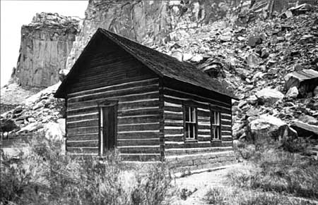
The historic Fruita Schoolhouse is located on the north side of State Highway 24, approximately .8 miles east of the visitor center. Constructed in 1896 by residents of the community, it served as a schoolhouse, meetinghouse, and community hall. All administrative and maintenance costs associated with the building were paid by the community until 1916, when the Wayne County School District assumed fiscal responsibility. In 1917 the flat roof was replaced with a gable roof. The building continued as a schoolhouse until 1941, when children were bused to central schools. The NPS restored the building in 1966 and 1968. The schoolhouse was listed in the National Register of Historic Places in 1972.
| |
| Fruita schoolhouse, 1993. | |
Merin Smith Implement Shed
The implement shed is located on the south side of the Scenic Drive approximately 1 mile from the visitor center. It was constructed as an implement shed and blacksmith shop by Fruita resident Merin Smith, about 1925. He used the building over the years as a workshop, storage area, and garage. The building is rectangular, measuring approximately 23' x 26', with a gable roof and sandstone block walls.
Merin Smith Fruit Cellar
The fruit cellar is located northeast of the Sprang house on the south side of the Scenic Drive, approximately 1 mile from the visitor center. The structure is built into a bank which insulates the interior for the storage of fruits and produce. The building is rectangular and measures approximately 13' x 25', with an exposed east facade.
Ranger Station
The Ranger Station is located southwest of the visitor center. The building was designed by the NPS Branch of Plans and Designs and constructed in 1940 by the Civilian Conservation Corps. Built in the rustic style, the exterior walls are comprised of cut sandstone, with slightly battered walls, a gabled shingled roof, overhanging eves, and exposed rafter ends. The building measures approximately 25' x 30' with a 10' x 8' extension on the northeast corner. In the 1950s the structure served as a contact station and museum for the park. In 1959 the building was remodeled to accommodate the park headquarters and visitor center. When the visitor center was built in 1965, the ranger station was converted for use as the superintendent's office.
Sulphur Creek Lime Kiln
This structure is located on the north side of Sulphur Creek, approximately .3 miles south west of the visitor center. The exact date and builder are unknown. The structure itself is circular, approximately 10 feet in diameter, and built into the side of a hill. The lower portion of the structure is built of sandstone block, while the upper portion is built of rounded, irregular stone. There is an opening (vent) on the top, and a small opening (for charging) at the bottom.
Sprang House
The Sprang house is located on the north side of the Scenic Drive, about 1 mile east of the visitor center. The building was constructed in 1957 for Elizabeth and Richard Sprang, who resided and worked there as artists for 5 years. Richard Sprang was a well-known cartoon illustrator. The building is a rectangular, wood frame building with a low gable roof. The house was built on the site of an earlier residence and has been altered over the years. It is currently vacant. This building has been determined ineligible for listing in the National Register of Historic Places.
Brimhall House
This structure is located on the north side of the Scenic Drive, approximately .3 miles from the visitor center. It was built by Dean Brimhall between 1956 and 1960, who purchased the property from Orval Mott in 1943. The current building is wood frame with plywood siding. The north side of the building is two stories with a flat roof. Brimhall owned the building until 1961 when it was purchased by the NPS. The building has been modified over the years, and currently serves as seasonal housing for volunteers. This structure has been determined ineligible for listing in the National Register of Historic Places.
| |
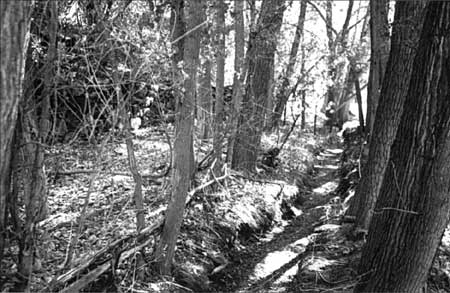
| Main ditch along the north edge of the district, 1993. | |
Irrigation System
Historically, the orchards and fields in Fruita were watered by an extensive hand-dug irrigation system, portions of which were in place as early as 1895. The earliest ditch drew water from the Fremont River and provided water to the Nels Johnson and J. Sorensen farms. [38] During early settlement, individual land owners diverted water as needed from Sulphur Creek and the Fremont River to water fields and orchards. By 1900 it was evident a more sophisticated and reliable system of irrigation would be required to sustain the agricultural landscape. As was traditional in Mormon communities, several families probably cooperated to construct the irrigation system in Fruita. [39] As designed, the system diverted water from both the Fremont River and Sulphur Creek, and included a series of open canals, diversion dams, ditches, furrows, sluice channels, flumes, and headworks. [40] In order to supply the necessary flow, the main intake was located along the Fremont River, approximately 2 miles from its confluence with Sulphur Creek. From this point, open ditches and flumes were constructed to carry water along the east face of Johnson Mesa, to the estimated 80 acres of irrigated lands. Gates controlled flow into the fields. The fields themselves were watered by furrow irrigation. In this system, water was carried from the main ditch to a series of laterals along the edges of the fields and finally into furrows that channelled water into shallow ditches spaced between rows of fruit trees, virtually flooding the land. Over the years the system required a high level of maintenance. Open ditches had to be constantly cleared of vegetation, silt, and debris; soils proved to be too unstable and main lines were undermined; flumes were lost to flooding; and field patterns and orchards changed, requiring the reconfiguration of entire segments of the system. In spite of these problems, the system remained viable into the 1940s.
| |
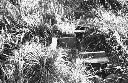
| Irrigation gate in the Johnson Orchard, 1993. | |
| |
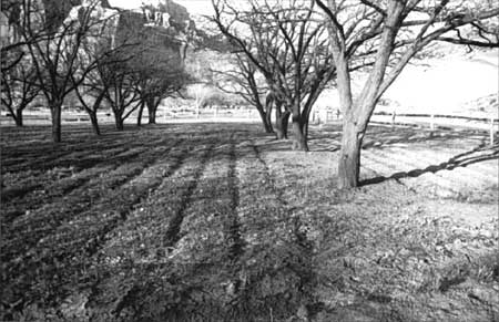
| Furrow ditches in the Mulford Orchard, 1993. | |
With the change in land ownership, the community-based work force for maintaining the system was gone. This did not, however, eliminate the use or promotion of the irrigation works. Several new landowners invested in repairing the system and promoted its upkeep. Most of the repairs targeted changes that would reduce the high level of cyclic maintenance by upgrading the existing system using more modern materials. For example, cast iron pipes were installed along the main line from the intake point on the Fremont River, replacing wooden flumes which were by then inefficient and prone to failure. In addition, flooding repeatedly wiped out extensive portions of the irrigation system, requiring redigging, cleaning, and in some cases, rerouting of ditches. More significant changes to the system were made in 1975 when the NPS added a settling pond, improving one intake, and converted some open ditches to buried pipe. In 1982 a sprinkler system was added to the Jorgensen Pasture to prevent overloading of the septic system serving the campground. In 1987 a concrete sluice channel was constructed near the settling pond to man age silt more effectively.
| |
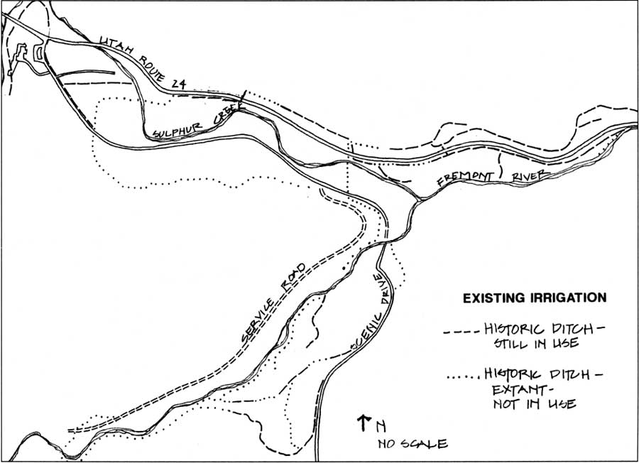
|
Fruita Irrigation System, 1992. (click on image for an enlargement in a new window) | |
Today a relatively large portion of the historic irrigation system is visible. Approximately one-half of the historic ditches are still in use throughout the district, another one-fourth are extant and occasionally catch run-off, and the remaining one-fourth have been abandoned, replaced, or survive as remnant segments. Portions of the original system and remnants of flumes can be found throughout the district and at intake points along the Fremont River. [41] With the exception of the Jorgensen Pasture, all existing agricultural land in the district is watered by furrow irrigation. The entire system continues to work by gravity flow.
| <<< Previous | <<< Contents >>> | Next >>> |
http://www.nps.gov/care/clr/clr4g.htm
Last Updated: 01-Apr-2003