|
Capitol Reef National Park Utah |
|
 NPS photo | |
. . . the light seems to flow or shine out of the rock rather than to be reflected from it.
—Clarence Dutton, geologist and early explorer of Capitol Reef, 1880s
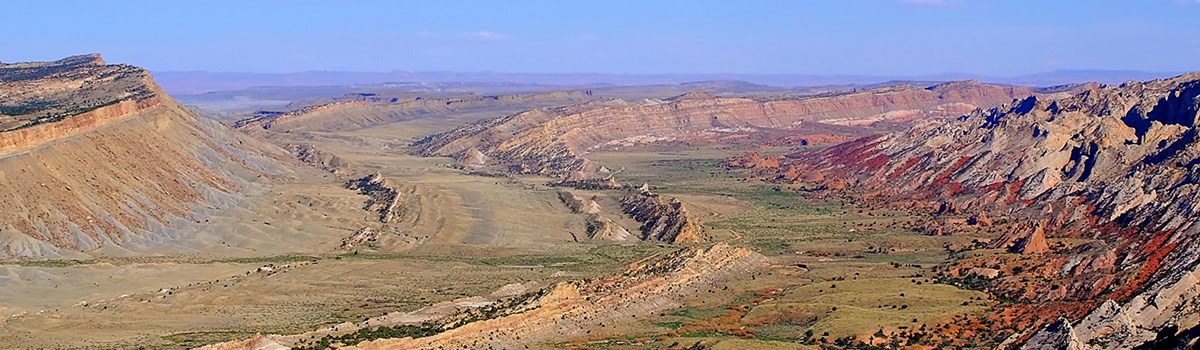
A Wrinkle in the Earth
A vibrant palette of color spills across the landscape before you. The hues are constantly changing, altered by the play of light against the towering cliffs, massive domes, arches, bridges, and twisting canyons. Over millions of years geologic forces shaped, lifted, and folded the earth, creating this rugged, remote area known as the Waterpocket Fold.
Creating the Waterpocket Fold
Capitol Reef's defining geologic feature is a wrinkle in Earth's crust, extending nearly 100 miles from Thousand Lake Mountain to Lake Powell. It was created over time by three gradual, yet powerful processes—deposition, uplift, and erosion. The result is a classic example of a monocline, or one-sided fold, in the otherwise horizontal rock layers.
Deposition The climate and geography changed dramatically over the past 280 million years. The environment was once oceans, deserts, swamps, and riverbeds, creating nearly 10,000 feet of sedimentary rock made of limestone, sandstone, and shale.
Uplift Between 50 and 70 million years ago, an ancient fault was reactivated during a time of tectonic activity, lift in the layers to the west of the fault over 7,000 feet higher than those to the east. Rather than cracking, the rock layers folded over the fault line. Continued uplift occurred again some 20 million years ago.
Erosion Erosive forces sculpted uplifted rock layers. Much of the carving occurred between one and six million years ago. Water, along with the pull of gravity, is the primary erosive force here. Powerful rains, flash flooding, and freeze-thaw cycles loosen, crack, and wash away stone, creating canyons, cliffs, domes, and bridges.
A Patchwork of Life
Look closely. This landscape can be deceiving. It may appear barren and lifeless, but it is home to a rich diversity of plant and animal species. Variations in topography, geology, elevation, and precipitation combine to create seven zones teeming with life. This high desert is a patchwork of pinyon-juniper forest; ponderosa and mixed conifer forest; grasslands; riparian habitats; mixed-shrub; and badlands—home to over 100 species of mammals, reptiles, amphibians, and fish; 239 species of birds; over 900 species of plants; and 33 ecological systems.
Living here has its challenges. Plants and animals have adapted, physically and behaviorally, to survive in this land of excessive heat, seasonal flash floods, winter snow, and variable, low precipitation. Climate change is resulting in increasing temperatures, more erratic precipitation, and intense solar radiation. How will they cope and adapt?
Living on the Reef
American Indians
Carvings (petroglyphs) and paintings (pictographs) on rock walls are
reminders of the people who lived here from about 300 to 1300 Common Era
(CE) and even earlier. They were ancestors of the modern-day Hopi, Zuni,
and Paiute tribes. The stories told on these rock walls depict maps,
journeys, clan symbols, deities, animals, and calendars. People farmed
the fertile land adjacent to the Fremont River and other nearby creeks.
They supplemented crops by hunting wildlife and harvesting nuts,
berries, and seeds. After 1300 CE no evidence of this culture is
found.
Travelers of the Past
The Waterpocket Fold territory was the last to be charted in the
contiguous 48 states. Throughout the 1800s numerous travelers ventured
into this land. Some were defeated by the imposing conditions. Others
prospered. Many left their mark on the Pioneer Register as they passed
through Capitol Gorge.
Pioneers
In the 1880s, Mormons established the small settlement of Fruita at the
confluence of the Fremont River and Sulphur Creek. They built irrigation
systems to water orchards and pastures, and sustain a self-reliant
agricultural lifestyle for decades. Families tended the apple, peach,
pear, and apricot trees. The park maintains the orchards, schoolhouse,
blacksmith shop, and the Gifford Homestead as reminders of pioneer
times.
Preserving the Past
Capitol Reef National Monument was established in 1937 and became a
national park in 1971. Today, millions of visitors from around the world
marvel at the majesty of the Colorado Plateau, the Waterpocket Fold, and
the rich natural and cultural features preserved for future
generations.
Jewels of the Night
Welcome to dark sky country where open skies and the desert landscape provide the perfect theater for stars to shine, twinkle, and amaze: Take a seat as daylight dims and the stars take center stage.
Truely dark skies are becoming rare. This natural lightscape is a critical nocturnal habitat. Many species of animals rely on natural patterns of day and night for navigation, to cue behaviors, and hide from predators. Ask a ranger what you can do to help protect the night sky.
Exploring Capitol Reef
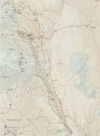 (click for larger map) |
Fruita Historic District
Includes the Fruita schoolhouse, blacksmith shop, the Gifford House
store and museum, and other buildings and features.
Orchards have apple, peach, cherry, pear, plum, apricot, and almond trees. Historic and heirloom varieties are found here. You may pick and eat fruit free of charge while in the orchards. A nominal fee is charged to take fruit with you. Harvest times vary. Check at the visitor center or call the fruit hotline 435-425-3791.
Facilities, Fees, and Services
Visitor Center The visitor center is open year round 8 am to 4:30
pm, with extended summer hours. Closed some federal holidays.
Information, orientation movie, exhibits, and bookstore are available.
Park entrance fees are collected at the north end of Scenic Drive and at
the visitor center. Nearby picnic area has picnic tables, grills,
restrooms, and drinking water.
Accessibility We strive to make mil facilities, services, and programs accessible in all. For information go to the visitor center, ask a ranger, call, or check our website.
Things To Do
Explore the beauty of Capitol Reef. Ranger led activities are offered
spring through fall. Schedules at the visitor center and on bulletin
boards. Ripple Rock Nature Center has interactive displays. Check at the
visitor center for hours.
The paved, 8 mile Scenic Drive offers breathtaking views of the Waterpocket Fold. Entrance fee is charged beyond Fruita campground. Allow about two hours for the round-trip drive.
A variety of trails from easy to strenuous offer many options to explorer the park. Please remember hiking in canyon country can be dangerous. • Hike with others and tell someone of your hiking plan. • Check at the visitor center for trail conditions. • Monitor weather and be prepared for extreme temperatures. • Sudden rains can cause flash floods. • Carry one gallon of drinking water per person per day. • Do not drink unpurified backcountry water. • Trail guides are sold at the bookstore.
Pets are permitted in developed park areas only, not on hiking trails. They must be restrained on a leash, six feet or less, at all times. Clean up pet waste and place in a dumpster.
Bicycles are restricted to public roads at all times.
Camping
Fruita Fee. Developed site, 71 spaces. Picnic tables, fire
grates/grills, restrooms, water, and RV dump station. First-come,
first-served. Limits: eight people per site.
Cathedral Valley and Cedar Mesa No fee. Primitive sites. Picnic tables, fire grates/grills, pit toilets, no water. First come, first served. Cathedral Valley has six sites and Cedar Mesa has five.
Group Site Available by written reservation only. Limit: 40 people.
Backcountry Camping Free backcountry permit is required. Available at the visitor center.
Safety and Regulations
Safety is your responsibility. • Be careful near cliff edges. • Carry
one gallon of drinking water per person per day. Do not drink unpurified
backcountry water • Watch for flash floods. Avoid canyon washes and
exposed areas when storms approach • Do not feed or disturb wildlife. •
Do not litter. Pack out all trash. • Hunting is prohibited in the park.
• For firearms regulations ask a ranger or check the park website. •
Off-road vehicle use is not permitted in the park. • Check road
conditions at the visitor center. • Ground fires are only allowed in
grates provided in campgrounds. • Do not disturb or collect plants,
animals, fossils, artifacts, and minerals.
Source: NPS Brochure (2016)
|
Establishment
Capitol Reef National Park — December 18, 1971 |
For More Information Please Visit The  OFFICIAL NPS WEBSITE |
Documents
A Catalog of Upper Triassic Plant Megafossils of the Western United States Through 1988 (Sidney Ash, 1989)
Annotated Checklist of Vascular Flora, Capitol Reef National Park NPS Natural Resource Technical Report NPS/NCPN/NRTR-2009-154 (Walter Fertig, January 2009)
Burr Trail Modifications, Final Environmental Impact Statement and Assessment of Effect, Capitol Reef National Park, Utah (December 2005)
Capitol Reef: The Forgotten National Park (©Jonathan Scott Thow, Master's Thesis Utah State University, 1986)
Capitol Reef Visibility Monitoring Site (undated)
Chemical and Biological Characteristics of Desert Rock Pools in Intermittent Streams of Capitol Reef National Park, Utah (Jil S. Baron, Toben LaFrancois and Boris C. Kondratieff, extract from Great Basin Naturalist, Vol. 58 No. 3, July 1998)
Cultural Landscape Report: Fruita Rural Historic District, Capitol Reef National Park (HTML edition) Cultural Resources Selections No. 8, Intermountain Region (Cathy A. Gilbert and Kathleen L. McKoy, 1997)
Effects of Livestock Grazing on Grassland Birds in Capitol Reef National Park, Utah NPS Technical Report NPS/NAUCARE/NRTR-94/05 (David W. Willey, June 1994)
Evaluation of Quality-Control Data and Quality Assurance for Routine Water Quality Monitoring: Bryce Canyon, Capitol Reef, and Zion National Parks, Water Years 2006–2013 NPS Natural Resource Report NPS/NCPN/NRR—2016/1154 (Rebecca H. Weissinger, March 2016)
Exploring the Burr Trail (1994)
Fact Guide for Capitol Reef National Park (2019)
Foundation Document, Capitol Reef National Park, Utah (January 2018)
Foundation Document Overview, Capitol Reef National Park, Utah (January 2018)
From Barrier to Crossroads: An Administrative History of Capitol Reef National Park, Vol. I (HTML edition) Southwest Cultural Resources Selections No. 12 (Bradford J. Frye, 1998)
From Barrier to Crossroads: An Administrative History of Capitol Reef National Park, Vol. II (HTML edition) Southwest Cultural Resources Selections No. 12 (Bradford J. Frye, 1998)
General Management Plan, Development Concept Plan, Final Environmental Impact Statement, Capitol Reef National Park - Utah (September 1998)
Geologic Resource Evaluation Report, Capitol Reef National Park NPS Natural Resource Report NPS/NRPC/GRD/NRR-2006/005 (September 2006)
Geology of the Capitol Reef Area, Wayne and Garfield Counties, Utah U.S. Geological Survey Professional Paper 363 (J. Fred Smith, Jr., Lyman C. Huff, E. Neal Hinrichs and Robert G. Luedke, 1963)
Geology of the Circle Cliffs Area, Garfield and Kane Counties, Utah U.S. Geological Survey Bulletin 1229 (E.S. Davidson, 1967)
Historic American Engineering Record
Capitol Reef National Park Roads (HAER No. UT-77)
Historical Survey and Base Map: Capitol Reef (Lenard E. Brown, June 30, 1969)
Impacts of Domestic Livestock Grazing on the Archeological Resources of Capitol Reef National Park, Utah Midwest Archeological Center Occasional Studies in Anthropology No. 20 (Alan Osborn, Susan Vetter, Ralph Hartley, Laurie Walsh and Jesslyn Brown, 1987)
Invasive Exotic Plant Monitoring in Capitol Reef National Park: 2019 Field Season, Scenic Drive and Cathedral Valley Road NPS Natural Resource Report NPS/NCPN/NRR-2021/2265 (Kristina Fahey and Dustin W. Perkins, June 2021)
Inventory Study Plan for Vascular Plants and Vertebrates: Northern Colorado Plateau Network (December 1, 2000)
Junior Ranger Activity Book, Capitol Reef National Park (Date Unknown; for reference purposes only)
Landscape Phenology, Vegetation Condition, and Relations with Climate at Capitol Reef National Park, 2000-2019 NPS Natural Resource Report NPS/NCPN/NRR-2023/2498 (David Thoma, March 2023)
Livestock Effects on the Tinajas of Capitol Reef National Park (Terence Boyle, 1987)
Livestock Grazing and Trailing Management Plan and Environmental Assessment, Capitol Reef National Park (July 2018)
Modern Wanderings Along the Waterpocket Fold: The Diary of Ralph Becker (Ralph Becker, extract from Utah Historical Quarterly, Vol. 83 No. 4, Fall 2015, ©Utah Historical Society)
Mormon Colonization of Southern Utah and in Adjacent Parts of Arizona and Nevada 1851-1900 (C. Gregory Crampton, 1965)
National Register of Historic Places Nomination Forms
Capitol Reef National Park Multiple Property Submission (Benjamin Brower and Kahy McKoy, April 15, 1996)
Cathedral Valley Corral (Benjamin Brower, 1995)
Civilian Conservation Corps Powder Magazine (Benjamin Brower, 1995)
Elijah Cutler Behunin Cabin (Benjamin Brower, 1995)
Fruita Schoolhouse (Gary D. Forbush, May 18, 1971)
Hanks' Dougouts (Benjamin Brower, K. McKoy and Lee Kreutzer, 1996, revised 1998)
Lesley Morrell Line Cabin and Corral (Benjamin Brower, 1995)
Oak Creek Dam (Benjamin Brower, 1995)
Oyler Mine (Benjamin Brower, 1995)
Pioneer Register (Benjamin Brower, 1995)
Natural Resource Conditions at Capitol Reef National Park: Findings & Management Considerations for Selected Resources NPS Natural Resource Report NPS/NCPN/NRR-2022/2406 (Kim Struthers, Lisa Baril and Mark Brunson, June 2022)
Park Newspaper (Capitol Reef Scene/The Cliffline): circa late 1980s • 1999
Plant Communities of Capitol Reef National Park, Utah NPS Technical Report NPS/NAUCARE/NRTR-93/02 (William H. Romme, Kenneth D. Heil, J. Mark Porter and Rich Fleming, September 1993)
Rock Formations in the Colorado Plateau of Southeastern Utah and Northern Arizona USGS Professional Paper 132-A (C.R. Longwell, H.D. Miser, R.C. Moore, Kirk Bryan and Sidney Paige, 1932)
Soil Survey of Capitol Reef National Park, Utah (2014)
Status and Trends in Upland Vegetation and Soils at Capitol Reef National Park, 2009-2018 NPS Natural Resource Report NPS/NCPN/NRR-2020/2139 (Dana L. Witwicki, June 2020)
Status and Trends in Upland Vegetation and Soils at Capitol Reef National Park, 2009-2018 (Revised with Cost Estimate) NPS Natural Resource Report NPS/NCPN/NRR-2020/2183 (Dana L. Witwicki, November 2020)
The diversity and stratigraphic distribution of pre-dinosaurian communities from the Triassic Moenkopi Formation, Capitol Reef National Park and Glen Canyon National Recreation Area, Utah (Debra L. Mickelson, New Mexico Museum of Natural History & Science Bulletin 34, 2006, ©New Mexico Museum of Natural History and Science, all rights reserved)
The Pectol/Lee Collection, Capitol Reef National Park, Utah (Lee Ann Kreutzer, extract from Utah Archaeology, Vol. 7 No. 1, 1994, ©Utah Statewide Archaeological Society and the Utah Professional Archaeological Council)
Vascular Flora and Vegetation of Capitol Reef National Park, Utah NPS Technical Report NPS/NAUCARE/NRTR-93/01 (Kenneth D. Heil, J. Mark Porter, Rich Fleming and William H. Romme, September 1993)
Vascular Plant Species Discoveries in the Northern Colorado Plateau Network: Update for 2008-2011 NPS Natural Resource Technical Report NPS/NCPN/NRTR-2012/582 (Walter Fertig, Sarah Topp, Mary Moran, Terri Hildebrand, Jeff Ott and Derrick Zobell, May 2012)
Water-Supply Possibilities at Capitol Reef National Monument, Utah USGS Water-Supply Paper 1475-G (I. Wendell Marine, 1962)
care/index.htm
Last Updated: 01-Jan-2025