|
Devils Postpile National Monument California |
|
 NPS photo | |
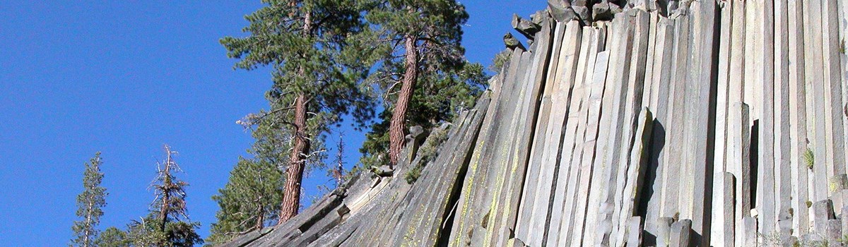
Outstanding Formation of Columnar Basalt
Welcome to Devils Postpile
Devils Postpile National Monument rests along the Middle Fork of the San Joaquin River on the Sierra Nevada's western slope (elevation 7,560 feet). The 800-acre monument preserves the columnar basalt formation, Devils Postpile, and 101-foot Rainbow Falls.
Originally part of Yosemite National Park, Devils Postpile lost its protective status in 1905 with pressure from local mining interests. They planned to dynamite the postpile to make a rock dam on the river. This threatened not only the postpile formation and falls but this vital watershed. Activists persuaded President William Howard Taft to restore federal protection to Devils Postpile and Rainbow Falls by proclaiming the national monument in 1911. In 1984 Congress included 687 acres of the park in the Ansel Adams Wilderness. The long-distance John Muir Trail and Pacific Crest National Scenic Trail traverse the park.
Beauty From Fire and Ice
A Volcanic Event About 82,000 years ago, basalt lava flowed here from an unknown source. This particular lava flow was ideal for column formation: It was thick with a consistent mineral composition, and it cooled slowly and evenly. As the lava cooled it contracted and split into the symmetrical, vertical, hexagonal columns that constitute Devils Postpile.
A Glacial Event Some 20,000 to 12,000 years ago a glacier flowed down the Middle Fork of the San Joaquin River and overrode the fractured mass of lava. The moving ice carved away one side of the postpile, exposing a sheer wall of columns 60 feet high. Erosion and earthquakes later felled many columns that now lie fragmented on the talus slope below the postpile.
Hiking atop Devils Postpile reveals a cross section of glacially polished columns that look like floor tiles—with parallel grooves cut in them by rock-studded glacial ice.
Rainbow Falls
The Middle Fork of the San Joaquin River plunges 101 feet over a cliff of volcanic rock. When the sun is overhead on a clear day, rainbows sparkle in the mist rising from rocks below the falls.
Glaciers widened the canyon but did not create Rainbow Falls. The two layers of volcanic rock you see in the cliffs are similar but with an important difference: They are composed of the same lava but they cooled at different rates. On top is the harder, more erosion-resistant rock. Below is the softer, less erosion-resistant rock. Water cascading over the falls wears away the lower, softer rock faster, undercutting the stronger rock and creating an alcove beneath it. As the stronger rock loses support, it caves in and breaks apart into the boulders and rock debris at the bottom of the falls.
Exploring Devils Postpile
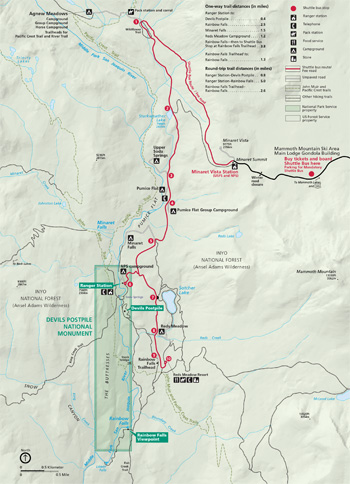 (click for larger map) |
Devils Postpile National Monument is usually open mid-June to mid-October and closed in winter. For information, call or check the park website.
Shuttle Bus From mid-June into September day-use visitors and backpackers going to Devils Postpile and Reds Meadow must ride the shuttle bus. Buy tickets and board buses at Mammoth Mountain Adventure Center. For schedules, fees, and other information, call or visit the park website.
Ranger Station Park rangers give interpretive programs, answer questions, help plan your visit, and enforce regulations.
Hiking Trails Hike west on the King Creek Trail or north-south on the John Muir and Pacific Crest trails. The 211-mile-long John Muir Trail links Yosemite with Sequoia and Kings Canyon national parks, with access at Rainbow Falls trailhead and the ranger station. The Pacific Crest National Scenic Trail goes from Canada to Mexico. For wilderness permits contact Inyo National Forest. Backpackers must use the shuttle—racks hold backpacks—or walk.
| One-way trail distances (in miles) | |
|---|---|
| Ranger Station to: | |
| Devils Postpile | 0.4 |
| Rainbow Falls | 2.5 |
| Minaret Falls | 1.5 |
| Reds Meadow Campground | 1.2 |
| Rainbow Falls—then to Shuttle Bus Stop at Rainbow Falls Trailhead | 3.8 |
| Rainbow Falls Trailhead to: | |
| Rainbow Falls | 1.3 |
| Round-trip trail distances (in miles) | |
| Ranger Station-Devils Postpile | 0.8 |
| Ranger Station-Rainbow Falls | 5.0 |
| Rainbow Falls Trailhead-Rainbow Falls | 2.6 |
Camping A 21-site campground near the ranger station is open mid-June-September, weather permitting. Bear-proof food storage lockers are provided (see bear warning). No reservations, hookups, or showers.
Fishing/Hunting Fishing in the national monument requires a California fishing license for persons age 16 or older. Hunting is prohibited.
Pets Pets are allowed on all park trails and in the campground. Pets must be leashed and under direct physical control at all times.
Bicycles Bicycles are permitted on roads but prohibited on all trails or crosscountry.
Bear Aware! Bears live here. Federal law requires proper food storage. Ask for details.
Accessibility We strive to make our facilities, programs, and services accessible to all. For information, call or check the park website.
For a Safe Visit Stay on designated trails. • Stay back from cliff and gorge edges; falls can be fatal. • Snowmobiling prohibited. • Climbing on the postpile formation prohibited. • Federal laws protect all natural and cultural features. Do not remove or disturb plants, rocks, or animals. • For all regulations, including firearms policy, check our website.
Two federal agencies work as partners to manage public lands in this area. The National Park Service oversees the 800-acre Devils Postpile National Monument, while the US Forest Service manages the lands surrounding the monument. Both agencies are also responsible for wilderness areas. Monuments, forests, and wilderness areas may have different rules that reflect their different goals. Check with a ranger to find out what activities are permitted in different areas.
Source: NPS Brochure (2017)
|
Establishment
Wild Trout River — 1995 |
For More Information Please Visit The  OFFICIAL NPS WEBSITE |
Documents
Cenozoic Volcanic Rocks of the Devils Postpile Quadrangle, Eastern Sierra Nevada California USGS Professional Paper 554-D (N. King Huber and C. Dean Rinehart, 1967)
Foundation Document, Devils Postpile National Monument, California (January 2017)
Foundation Document Overview, Devils Postpile National Monument, California (January 2017)
Frequency of Volcanic Eruptions in the Mammoth Lakes Sierra USGS Fact Sheet 2018-3059 (Wes Hildreth, Andrew Calvert, Judy Fierstein and Mae Marcaida, September 2018)
Geologic Resources Inventory Report, Devils Postpile National Monument NPS Natural Resource Report NPS/NRPC/GRD/NRR-2009/160 (J. Graham, February 2010)
Geologic Story of Devils Postpile (N. King Huber and Wymond W. Eckhardt, September 2000)
Inventory Surveys for Bats and California Spotted Owls at Devils Postpile National Monument: Final Report NPS Natural Resource Report NPS/DEPO/NRR-2023/2757 (Rachel Blakey, Monica Buhler, Lizzy Young, Bob Wilkerson and Rodney B. Siegel, October 2023)
Junior Ranger Activity Book, Devils Postpile National Monument (Date Unknown; for reference purposes only)
Natural Resource Condition Assessment for Devils Postpile National Monument NPS Natural Resource Report NPS/DEPO/NRR-2014/889 (Bill Kuhn and Terressa Whitaker, December 2014)
Natural Resources Management Statement for Devils Postpile National Monument (July 1974)
Natural Resources Management Statement for Devils Postpile National Monument (March 1982)
Nature and History on the Sierra Crest: Devils Postpile and the Mammoth Lakes Sierra (Christoper E. Johnson, 2013)
Park Newspaper (The Post): 2006 • 2009 • 2010 • 2011 • 2015 • 2016 • 2018 • 2019
Project Brief: Climate Monitoring and Reporting: Sierra Nevada Network (February 24, 2015)
Report on Sullys Hill Park, Casa Grande Ruin; the Muir Woods, Petrified Forest, and Other National Monuments, Including List of Bird Reserves: 1915 (HTML edition) (Secretary of the Interior, 1914)
Report on Wind Cave National Park, Sullys Hill Park, Casa Grande Ruin, Muir Woods, Petrified Forest, and Other National Monuments, Including List of Bird Reserves: 1913 (HTML edition) (Secretary of the Interior, 1914)
Statement for Management — Devils Postpile National Monument, California (1978)
The Devils Postpile National Monument (N. King Huber and C. Dean Rinehart, extract from Mineral Information Service, Vol. 18 No. 6, June 1965)
depo/index.htm
Last Updated: 01-Jan-2025