|
Fort Pulaski National Monument Georgia |
|
 NPS photo | |
In the second quarter of the 19th century, U.S. military engineers built Fort Pulaski on marshy Cockspur Island to guard the river approaches to Savannah, Ga. Named for Count Casimir Pulaski, the Polish hero of the American Revolution who lost his life in the unsuccessful siege of Savannah in 1779, it was designed by Gen. Simon Bernard, a distinguished French military engineer, as part of a coastal fortification system adopted by President James Madison after the War of 1812. Construction began in 1829 and required $1 million, 25 million bricks, and 18 years of toil to finish. Its admirers (and there were many) considered it invincible and "as strong as the Rocky Mountains." By the end of 1860, however, its armament was still not completed and it was not yet garrisoned. As it turned out, before United States troops could occupy the fort, they had to conquer it.
On January 3, 1861, two weeks after South Carolina seceded from the Union and one week after Federal troops occupied Fort Sumter in Charleston Harbor, Georgia Gov. Joseph E. Brown ordered state militia to seize Fort Pulaski. At this time Savannah was a city of about 20,000 inhabitants and a rich seaport trading in cotton, naval stores, and timber. Though many disagreed on the wisdom of seizing the Federal fort, people of all classes joined in preparations for its defense following the occupation. After Georgia seceded on January 19, 1861, the state transferred Fort Pulaski to the Confederate States of America.
By the end of April 1861, 11 Southern states had left the Union and were at war with the United States. Before the end of the summer. President Abraham Lincoln ordered the U.S. Navy to blockade Southern ports. As the blockade tightened it strangled the Confederate economy. On November 7, 1861, a combined Army and Navy expedition struck at Port Royal Sound, S.C., about 15 miles north of Fort Pulaski. Confederate troops fled as Federal warships bombarded Forts Walker and Beauregard, allowing Union forces to land unopposed on Hilton Head Island. From this beachhead, the Federals established a base for operations against Fort Pulaski and the whole southern Atlantic Coast.
On November 10, intimidated by the Federal presence at Hilton Head, the Confederates abandoned Tybee Island at the mouth of the Savannah, unknowingly giving the enemy the only site from which Fort Pulaski could be taken. The Federals acted quickly to take advantage of the break. Early in December they cut the fort's communications with the mainland, then moved troops to Tybee Island to prepare for siege operations.
Engineer Capt. Quincy A. Giilmore, who assumed command of all troops on Tybee Island in February 1862, believed that an overwhelming bombardment would force the Confederates to give up the fort. Accordingly, he erected 11 artillery batteries containing 36 guns and mortars along the northwest shore of Tybee Island. On April 10, after the Confederates refused Gillmore's formal demand to surrender, the Federals opened fire. The Confederates were not particularly alarmed; the Union guns were a mile away, more than twice the effective range for heavy ordnance of that day. But what the fort's garrison did not know was that the Federal armament included 10 new experimental rifled cannons, whose projectiles began to bore through Pulaski's walls with shattering effect. By noon of the second day the bombardment had opened wide gaps in the southeast angle, and explosive shells, passing through the holes and over the walls, threatened the main powder magazine. Impressed by the hopelessness of the situation and concerned about the lives of his men, the Confederate commander. Col. Charles H. Olmstead, surrendered only 30 hours after the bombardment began.
Giilmore was the hero of the day. For his boldness in using a new weapon and for the victory won, he was breveted a brigadier general. Olmstead, along with the other 384 officers and men in Pulaski's garrison, was sent north and imprisoned at Governor's Island in New York. When he was exchanged in the autumn of 1862, he resumed command of his regiment and served with distinction for the remainder of the Civil War. Federal troops garrisoned Fort Pulaski until war's end, when it was used to house several political prisoners. After 1880 a caretaker and lighthouse keeper were the fort's only occupants. They too were soon removed, leaving the place to the ever-encroaching vegetation and animal life. The island was made a national monument in 1924; restoration of the fort began in earnest about 1933. Today the fort serves not only as a memorial to the valor and dedication of those connected with its construction, bombardment, and defense, but in a larger sense as a history lesson on the elusiveness of invincibility.
The End of an Era
The quick fall of Fort Pulaski surprised and shocked the world. When the Civil War began, Pulaski ranked as one of the "most spectacular harbor defense structures" in the United States. Many considered the fort's 7½-foot solid brick walls backed with massive masonry piers unbreachable, including U.S. Chief of Engineers Joseph G. Totten. "You might as well bombard the Rocky Mountains," was how he summed it up. All previous military experience had taught that beyond 700 yards smoothbore cannons and mortars would have little chance to break through heavy masonry walls; beyond 1,000 yards no chance at all. And since there was no firm ground on which siege batteries could be erected nearer than Tybee Island, a mile or more away, Pulaski's defenders felt understandably secure. Even Gen. Robert E. Lee, who as a second lieutenant had worked on the island's drainage system, told Colonel Olmstead that Federal gunners on Tybee Island could "make it pretty warm for you here with shells, but they cannot breach your walls at that distance." Gillmore's rifled guns proved the fallacy of that judgment. "The result of this bombardment," wrote one Union officer, "must cause . . . a change in the construction of fortifications as radical as that foreshadowed in naval architecture by the conflict between the Monitor and Merrimac. No works of stone or brick can resist the impact of rifled artillery of heavy calibre." The strategy that heretofore had guided military leaders had to be revised to meet the threat of this new weapon of war. Fort Pulaski, because of the consequent changes, became an interesting relic of a bygone era.
For two months Union forces hauled 36 mortars and smoothbore and rifled cannon across the sand and marsh of Tybee Island—often at night and in virtual silence—to prepare for the siege of Fort Pulaski. Five of the 10 rifled cannon used against the fort were 30-pounder Parrott guns, which had an effective range of 8,453 yards. Rifled cannon, unlike conventional smooth-bore artillery, had spiraled or rifled grooves inside the barrel. An expansion skirt or ring on the projectile engaged the rifling in the barrel, providing a spin to the bullet-shaped shell. This spin gave the projectile increased accuracy, range, and penetration power unmatched by the spherical shot of smoothbore guns. Thus even from a distance of about one mile, shots from the rifled guns penetrated Fort Pulaski's walls with relative ease.
Third System Forts
Fort Pulaski belonged to what is known as the Third System of coastal
fortifications, developed during the first half of the 19th century and
characterized by greater structural durability than earlier works.
Nearly all of the 30-plus Third System forts built after 1816 still
exist.
Col. Charles H. Olmstead
His decision to surrender Fort Pulaski haunted him for decades. "We were
absolutely isolated," he later wrote, "beyond any possibility of help
from the Confederate Authorities, and I did not feel warranted in
exposing the garrison to the hazard of the blowing up of our main
magazine—a danger which had just been proved well within the limits
of probability. . . . There are times when a soldier must hold his
position 'to the last extremity,' which means extermination, but this
was not one of them. . . . That the fort could and would be absolutely
destroyed by the force of the enemy was a demonstrated fact, . . . while
our own power to harm them had been reduced to a minimum. . . . I am
still convinced that there was nothing else that could be done."
A Guide to Fort Pulaski
Moat
This wet ditch that completely surrounds the fort is seven feet deep and
from 32 to 48 feet wide. The water was brought through a canal from the
Savannah River and controlled by tide gates. A variety of small marine
life inhabits the moat.
Demilune
This huge triangular piece of land, bordered on all sides by the moat,
protected the rear or gorge wall of the fort. During the Civil War, this
area was flat with a surrounding parapet and contained outbuildings and
various storage sheds. The large earthen mounds, built after the war,
overlay four powder magazines and passageways to several gun
emplacements.
Drawbridge
A part of the fort's overall defense, the drawbridge is to make forced
entry difficult. As it is raised, a strong wooden grille, called the
portcullis, drops through the granite lintel overhead; bolt-studded
doors are closed behind that. An inclined granite walk leads between two
rows of rifle slits, past another set of doors, and into the fort.
Gorge Wall
This, the rear section of the fort, contains the sally port, or fort
entrance. Officers lived in most of the rooms here. Today several are
furnished to represent various aspects of life at the fort.
Northwest Magazine
On the morning of April 11, 1862, Union artillery projectiles breached
the southeast angle and crashed into the walls and roof of this magazine
containing 40,000 pounds of gunpowder. Rather than be blown up by their
own gunpowder, the garrison surrendered. The walls of the magazine are
from 12 to 15 feet thick, or roughly four feet thicker than the rest of
the walls in the fort.
Confederate Defense System Confederate defenders of the fort built earthen traverses between the guns and over the magazine and dug ditches and pits in the parade ground to catch rolling cannon shot. They also erected a heavy timber blindage (splinter-proof shelter) to cover the interior perimeter of the fort to protect against shell fragments.
Prison
During the winter of 1864, the northeast, southeast, and part of the
south casemates were used as a military prison holding Confederate
officers under miserable conditions. After the war, several political
prisoners were held here.
The Breach
The 714-foot-thick walls at this angle were demolished by Union rifled
artillery on April 10-11, 1862, forcing the Confederates to surrender
the fort. The walls were repaired within six weeks after the surrender
by troops of the 48th New York Volunteers.
Southwest Bastion
This bastion, which burned in an 1895 fire, has been left unrestored to
show various construction details of the fort. Brick arches under the
terreplein (the upper level upon which the cannons are mounted) carry
weight to counterarches in the floor which, in turn, are supported by a
timber grillage and piling driven 70 feet into the mud of Cockspur
Island.
Surrender Room
These were the quarters of the Confederate commanding officer, Col.
Charles Olmstead. In this room on April 11, 1862, Olmstead surrendered
Fort Pulaski to Union forces after some 30 hours of bombardment.
Cistern Room and Restrooms
The cistern exposed here is one of 10 that were used to store fresh
water. Rain filtered through the sod on the terreplein ran down lead
pipes in brick piers and thence to the tanks. The whole system could
hold more than 200,000 gallons.
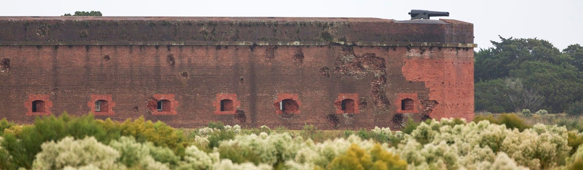
Damaged Wall
The craters made by Union artillery projectiles pock the south and
southeast walls. Rifled cannon shot fired from Tybee Island penetrated
the walls 20 to 25 inches. Some of the 5,275 shots fired can still be
seen in the wall.
Things You Should Know
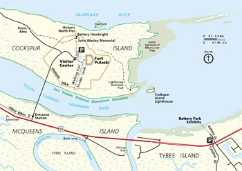 (click for larger map) |
As you tour the fort, think of what it was like when it was in active military use. During Confederate occupation, there were 385 officers and men; Federal strength reached a peak of 1,100. (Each side lost one man here.) The fort was designed for 140 cannon, but Union troops installed only 60.
Please watch your step in and around the fort, for most of it is in its original state. Some sections, like the veranda over the gorge wall and the brick walk around the fort have been rebuilt; others, like the rooms in the gorge, have been restored. New mortar (repointing) has many parts of the brick work.
Cockspur Island was originally a series of small hammocks surrounded by salt marsh. It is now mostly dry land because dredged materials have been deposited outside the dikes around the fort. McQueens Island, however, is mostly virgin salt marsh. Temperatures range from 20°F in winter to 100°F in summer.
Here you can see luxuriant, semi-tropical plants intermixed with those of the temperate and desert zones. Here, too, are large populations of resident and migratory birds. Mammals include marsh rabbits, raccoons, opossums, and mink. Occasionally an alligator will enter the moat when the water level drops on the rest of the island, but generally they shun people and live elsewhere.
There are many snakes in and around the fort in spring and summer. Most of these are harmless and serve as natural mice and rat predators. Of the many species of reptiles here, only the eastern diamondback rattlesnake is poisonous. Please do not tease or molest these animals or any other wildlife.
Alcohol is not permitted within the historic dike system. Open containers of alcohol are prohibited within the passenger compartments of motor vehicles.
All cultural and natural resources are protected by law. Climbing on historic features is not permitted. The possession of metal detectors is prohibited. For firearms regulations, visit the park website.
This is a special place. Many parts of the fort are fragile. Please help us protect it, as well as you and your family, from injury. Obey all signs, watch your step, stay away from edges, and use caution in stairwells.
Fort Pulaski is open daily, except Thanksgiving Day and December 25, from 9 am to 5 pm, with extended hours in summer. The park can be reached via U.S. 80 from Savannah.
Audio Stations
You can hear brief taped messages about Fort Pulaski at many locations
on the tour described above. Look for small gray boxes mounted on the
walls. Push the button on the box to hear the recorded message.
Trails
Along the park trails, you can see the variety of plant and animal life
on the island. A short distance from the fort is a monument to John
Wesley, founder of Methodism, who landed in America in 1736 at Cockspur
Island.
For Your Safety
Stay off mounds and topmost walls of the fort. • Don't run on the
terreplein (upper level) of the fort. • Come down from the
terreplein when there is lightning. • Keep pets leashed or
otherwise physically restrained. • Mosquitos, gnats, and horseflies
are present in spring and summer; use a repellent or wear protective
clothing. • Watch your step in the fort and stay on the trails when
walking or hiking. If you have questions or need assistance in any way
while visiting the park, please don't hesitate to ask us. Enjoy your
visit. Service animals are welcome.
Source: NPS Brochure (2012)
|
Establishment Fort Pulaski National Monument — October 15, 1924 |
For More Information Please Visit The  OFFICIAL NPS WEBSITE |
Documents
A Connecticut Yankee on the Georgia Coast: The Engineering Epic of Fort Pulaski, 1821-1861 (Rogers W. Young, 1938)
A Report on Structural Issues in the Demilune at Fort Pulaski National Monument, Cockspur Island near Savannah, Georgia (Bennett Preservation Engineering PC, April 30, 2020)
Administrative History: Fort Pulaski National Monument (J. Faith Meader, Cameron Binkley, ed., December 2003)
African Americans at Fort Pulaski, 1733-1900: A Special History Study (Julie de Chantal, Heidi Moye and Anastatia Sims, April 2022)
Archeological and Historical Investigations At Battery Hamilton (9CH953), Chatham County, Georgia Georgia Department of Transportation Occasional Papers in Cultural Resources Management #12 (Chad O. Braley, 2008)
Assessment of Estuarine Water Quality at Fort Pulaski National Monument, 2007 NPS Natural Resource Data Series NPS/SECN/NRDS-2010/117 (M. Brian Gregory,, Joe DeVivo,, Phillip H. Flournoy and Katy Austin Smith, December 2010)
Assessment of Estuarine Water Quality at Fort Pulaski National Monument, 2014 NPS Natural Resource Data Series NPS/SECN/NRDS-2015/801 (Wendy Wright, May 2015)
Development Concept Plan, Fort Pulaski National Monument (September 2024)
Cultural Landscape Report: Cockspur Island Historic District, Fort Pulaski National Monument (Susan Hitchcock, August 2011)
Echoes from the Past: The Archeology of Fort Pulaski
Fort Pulaski (Charles H. Olmstead, The Georgia Historical Quarterly, Volume 1, June 1, 1917)
Foundation Document, Fort Pulaski National Monument, Georgia (August 2016)
Foundation Document Overview, Fort Pulaski National Monument, Georgia (January 2016)
Fort Pulaski National Monument: Historic Handbook #18 (Ralston B. Lattimore, 1954)
Fort Pulaski National Monument: Historic Handbook #18 (Ralston B. Lattimore, 1954, reprint 1961)
Historic Structure Report: Battery Horace Hambright, Fort Pulaski National Monument, Georgia (Panamerican Consultants, Inc. and Wiss, Janney, Elstner Associates, Inc., February 2019)
Historic Structure Report: Fort Pulaski, Fort Pulaski National Monument, Chatham County, Georgia (Wiss, Janney, Elstner Associates, Inc., October 2014)
Historic Structure Report: Visitor Center, Fort Pulaski National Monument, Georgia (Panamerican Consultants, Inc., Wiss, Janney, Elstner Associates, Inc. and WFT Architects, July 2019)
Historic Structures Report: West End Bunkers, Fort Pulaski National Monument, Georgia (Liz Sargent HLA and Wiss, Janney, Elstner Associates, Inc., July 2024)
Landbird Community Monitoring at Fort Pulaski National Monument, 2010 NPS Natural Resource Data Series NPS/SECN/NRDS-2011/302 (Michael W. Byrne, Joseph C. DeVivo and Brent A. Blankley, September 2011)
Masonry Forts of the National Park Service: Special History Study (F. Ross Holland, Jr. and Russell Jones, August 1973)
Master Plan: Fort Pulaski National Monument, Georgia (1971)
National Register of Historic Places Nomination Form
Fort Pulaski National Monument (Edward L. Trout, December 11, 1974)
Natural Resource Condition Assessment (with addendum), Fort Pulaski National Monument, Georgia NPS Natural Resource Report NPS/NRPC/WRD/NRR-2009/103 (Jessica L. Dorr, Scott D. Klopfer, Ken M. Convery, Rebecca M. Schneider, Linsey C. Marr and John M. Galbraith, May 2009)
Natural Resource Conditions at Fort Pulaski National Monument: Findings and Management Considerations for Selected Resources NPS Natural Resource Report NPS/FOPU/NRR-2023/2555 (Kim Struthers, August 2023)
Park Newspaper (Fort Pulaski Press): Vol. 1 issue 1, Summer 2007 • Vol. 1 issue 2, Fall 2007 • Vol. 2 issue 1, Summer 2008
Quarantine Attendants' Quarters, Historic Structure Report, Fort Pulaski National Monument (March 2004)
Robert E. Lee and Fort Pulaski: NPS Popular Study Series No. 11 (Rogers W. Young, 1941)
Sand and Grit: The Story of Fort McAllister; A Confederate Earthwork on the Great Ogeechee River, Genesis Point, Georgia (R. Jervis Cooke, 1938)
Siege and Surrender of Fort Pulaski (Ralston B. Lattimore, 1934)
Siege of Savannah Battle Site, 1779 (Horace J. Sheely, Jr., September 9, 1965)
Summary of Amphibian Community Monitoring at Fort Pulaski National Monument, 2010 NPS Natural Resource Data Series NPS/SECN/NRDS-2011/139 (Michael W. Byrne, Briana D. Smrekar, Marylou N. Moore, Casey S. Harris and Brent A. Blankley, February 2011)
Terrestrial Vegetation Monitoring at Fort Pulaski National Monument: 2019 Data Summary NPS Natural Resource Data Series NPS/SECN/NRDS-2021/1339 (M. Forbes Boyle and Elizabeth Rico, December 2021)
The Arming of Fort Pulaski 1826-1861 (Rogers W. Young, 1935)
The investment of Fort Pulaski (Alonzo Williams, 1887)
The Tide Is Coming In: Fort Pulaski's Historical Relationship With Water (©Sadie Ingram, Thesis Georgia Southern University, April 2021)
Vegetation Community Monitoring at Fort Pulaski National Monument, 2010 NPS Natural Resource Data Series NPS/SECN/NRDS-2012/252 (Michael W. Byrne, Sarah L. Corbett and Joseph C. DeVivo, February 2012)
Vegetation Mapping at Fort Pulaski National Monument NPS Natural Resource Report NPS/SECN/NRR-2013/718 (Rachel H. McManamay, Anthony C. Curtis and Sarah Corbett Heath, October 2013)
Water Quality and Nuisance Species Management in the Fort Pulaski National Monument Moat NPS Natural Resource Report NPS/SECN/NRR-2009/134 (Kayla Nimmo and Eva DiDonato, July 2009)
fopu/index.htm
Last Updated: 01-Jan-2025