|
Fort Vancouver
Cultural Landscape Report |

|
II. FORT VANCOUVER: TRANSITION, 1829-1846
1829-1846
The period between 1829 and 1846 encompasses the principal period of development of Fort Vancouver under the Hudson's Bay Company. During this time, which begins with a major site development--the move of the fort proper from its original site to the location of the present reconstruction--Fort Vancouver's economic, political and social influence in the region reached its peak. The boundaries of the site were at their greatest extent. The Fort's administrative importance, as vested in Chief Factor John McLoughlin, was supreme in the Pacific Northwest While fur-trading activities declined throughout this period, agricultural activity under the Hudson's Bay Company flourished, with Fort Vancouver as the administrative and producing hub. In addition, many early industrial activities were initiated and developed at the fort--including large-scale timber milling, salmon fisheries, grain milling--which led to its prominence in Pacific Coast trade, with trading connections in Hawaii, California, and Alaska. The fort was the social center for the region throughout most of the period, with balls, plays, picnics and dinners attracting settlers from many miles away. During the latter years of this period, the Company's stores at the fort and cattle, seed, and produce from its fields, provided the first waves of American settlers in the region with the means to establish their farms--in some cases with the means to survive their first winter; these operations had a significant influence on the settlement of the region, from Puget Sound in Washington to the Willamette Valley in Oregon, and east as far as the Dalles, Oregon. Against a backdrop of the influx of American settlers, with attendant political and economic agendas and under a threatened imminent settlement of the northwest boundary dispute between Great Britain and the United States, the period ended with two events of particular significance: first, the signing of the Oregon Treaty of 1846, finally resolving the boundary issue; second, London's decision to terminate McLoughlin's superintendency of Fort Vancouver.
Administrative and Political Context
During this period Fort Vancouver served as the administrative center for the company's posts west of the Rocky Mountains. While American fur traders periodically mounted expeditions into the west, the Hudson's Bay Company, with its increasing number of trading posts--both on the coast and inland--and with established methods and routes for trade goods, fur processing and export, and a sufficient means of provisioning its posts and employees, dominated the trade in peltries until the rich fur resources of the region finally began to give out. Simpson's policy of increasing the supply of "in-country" produce, reducing the reliance on imported provisions, spurred the development of agriculture and other industries under Company aegis, which ultimately led, in the late 1830s, to the establishment of the Puget's Sound Agricultural Company (P.S.A.C.), a subsidiary of the Hudson's Bay Company. This, in turn, made the Company the major player in Pacific Coast trade.
Early American missionaries in the Pacific Northwest ended their arduous overland treks and ocean voyages at Fort Vancouver, the principal settlement in the region in the 1830s, where they received necessary supplies, livestock and equipment to begin their own establishments. They were instrumental in publicizing the attractions of the rich Willamette Valley to land-hungry Americans in the States; in the late 1830s, the first wave of settlers reached the Oregon Country. Up until 1842-43, Fort Vancouver served as the principal supplier of food, clothing and materials to start a farm; the Company expanded its merchandizing and milling operations, opening stores in San Francisco, Oregon City and the Willamette Valley, and mills in Oregon City and Champoeg.
The principal political backdrop during this period was the uncertainty regarding the final location of the boundary between British and American territory in the Pacific Northwest In August of 1827 the joint occupation agreement regarding the disputed land was indefinitely extended, leading the Hudson's Bay Company to augment operations at Fort Vancouver's strategic Columbia River location, and for some years it was generally believed the boundary would be established along the lower Columbia River, leaving Fort Vancouver in British territory. By the 1840s, with the influx of American settlers into the Oregon Country, British assumptions regarding the boundary became increasingly unrealistic. In 1846 the Oregon Treaty was signed, establishing the boundary at the 49th parallel, legally ending British dominion over lands the Company had developed and exploited for over twenty years.
Seat of Columbia Department
Fort Vancouver became the supply center and administrative locus for an expanding number of fur-trading posts and two agricultural outposts. Returns from the Columbia Department and New Caledonia fur brigades were shipped via canoe and bateaux to Fort Vancouver, where they were inspected, prepared for shipment and recorded, and then loaded on the annual supply ships sent from London. From Fort Vancouver, annual supplies and trade goods for each post were ordered from London, and repacked, invoiced and shipped out to the posts. Under McLoughlin's direction, fur brigades were sent from the various posts to trap out the areas south and east of the Columbia River region, creating a "fur desert," which, combined with control of the Indians and various sales and bidding strategies for furs, was largely successful in ruining American competitors in the region. 103 By the early 1830s the rich fur resources of the Snake River region had been decimated by the Company, and by the early '40s, fur brigades to California, which had been conducted annually since 1835, ceased to be profitable.
A number of new posts were established during this period, including Fort Boise, in what is now Idaho, Fort Simpson, on the Nass River in Alaska (1831); Fort McLoughlin on Millbanke Sound (1833), and Fort Nisqually and Cowlitz Farm, the latter two principally as agricultural centers. At the end of this period, the Columbia Department posts administered from Fort Vancouver included the aforementioned forts, as well as Fort George, Fort The Dalles, Fort Nez Perces, Fort Okanogan, Fort Colvile, Fort Flathead, Fort Kootenai, Fort Langley, Fort Rupert, Fort Umpqua, and Fort Victoria.
Over time each post within the Department came to rely more on produce raised "in country," including cattle, grain, and so forth, either from its own location, or from other posts, particularly Fort Vancouver, and later Cowlitz Farm and Fort Nisqually, a result of the policy formulated by Simpson and London to reduce the expense of transporting foodstuffs from London. McLoughlin's letters to chief factors and chief traders at various posts during this period often include specific instructions for agricultural production, for intra-post shipment of produce, seed and livestock, and for repairs of tools, structures and expensive manufactured items.
As the years progressed, Fort Vancouver, under John McLoughlin's administration, and following policies established by Governor George Simpson and the Company's London directors, became the principal manufacturing and agricultural center in the Pacific Northwest. Eventually, products from cattle, swine and sheep were used not only to sustain the Company's posts, but to barter and sell to immigrants and to export markets. Commodities harvested and produced at posts other than Fort Vancouver, such as salmon from Fort Langley, were part of the Columbia Department's production; the operations were overseen by McLoughlin at Fort Vancouver. Agricultural operations--tares, clover and other crops to sustain livestock, and a significant amount of wheat for milling and marketing to local consumers and for export--continued to expand throughout this period, overseen by the offices at Fort Vancouver. In addition, the Company's Pacific Coast trade--the operation of ships servicing Company posts and carrying exported and imported goods--was directed from Fort Vancouver.
As the Company's principal administrative representative in the region and head of the Columbia Department, Chief Factor John McLoughlin directed every aspect of Company operations, from relations with Indians and American immigrants, to quantities and methods of agricultural production at the various posts. Because Fort Vancouver was the Company's principal west coast center for import and export, Fort Vancouver clerks kept accounts and records of all orders and shipments in furs, produce and manufactured items received from, or sent, abroad or sold in-country in the Columbia Department. The scope and power lodged in McLoughlin, as the Columbia Department's Chief Factor during this period, is illustrated by arrangements made for administration while McLoughlin was on leave in 1838. While he was absent the posts on the upper Columbia were administered by one chief factor, Samuel Black; the maritime trade and expeditions and posts on the lower Columbia, including Fort Vancouver, were placed under the control of Chief Trader James Douglas; and the administration of New Caledonia, an area where McLoughlin apparently spent little administrative energies, was directed by Chief Factor Peter Skene Ogden, who already operated it on a mostly autonomous basis. When McLoughlin returned from his furlough in the fall of 1839, he resumed direction of these various operations, with the additional charge of heading the administration of the newly-established Puget's Sound Agricultural Company.
Fort Vancouver, as the Columbia Department depot, also administered a relatively short-lived merchandising venture in San Francisco (1841-45), and a trading establishment in the Hawaiian Islands (1833-1844). [104]
During the first few years of the 1840s, London began to express concern over some of McLoughlin's actions in the Columbia Department, including unauthorized expenditures at Oregon City and the credit advances he had been giving settlers. The Governor and Committee were also dissatisfied with the decline in revenues in the Department, and the failure of the Puget's Sound Agricultural Company to bring in projected profits. In 1841 George Simpson returned to the Columbia for the first time since 1828-29. He and Chief Factor McLoughlin disagreed on the operations of the coastal trade, and their increasingly bitter discussions ended in a quarrel. Then, in 1842, Simpson found upon revisiting Fort Stikine, where John McLoughlin, Jr., was in charge, that the Chief Factor's son had been murdered by his own men. Simpson's handling of the affair was unacceptable to McLoughlin, who then conducted his own inquiry into the matter, arrested the men involved in his son's death, and insisted they be tried for murder. His letters to the Governor and Committee over the next four years were full of references to his progress in his murder investigation, and of accusations against Simpson's handling of the affair, including lodging responsibility for the murder with Simpson, who he claimed had left his son in charge of Stikine without adequate help. London directed McLoughlin to resolve his differences with Simpson, but McLoughlin ignored the direction. In 1844 McLoughlin was removed as sole administrative head of the Columbia Department; a joint administrative board for the department was established, to take effect in 1844-45, with McLoughlin sharing administrative tasks with Chief Factors James Douglas and Peter Skene Ogden. Using McLoughlin's purchase of land in Oregon City--which he made, ostensibly, in the name of the Company to protect its interests under the Oregon territorial donation land claim law--as a wedge, Simpson was able to force McLoughlin into retirement. The Chief Factor left Fort Vancouver in January of 1846.
Boundary Issues
As noted previously, in the summer of 1824, Great Britain and the United States suspended boundary negotiations regarding the territory between the 49th parallel and the lower Columbia River, leaving its ultimate fate unresolved and resulting in the Hudson's Bay Company's determination to exploit the region's fur resources and the development of its west coast operations, particularly Fort Vancouver. However, between 1829 and 1846, immigrants from the United States--spurred by published reports of fertile land from a trickle of early settlers and from American missionaries--began to settle in what became known as the Oregon Country, particularly in the Willamette Valley south of the Columbia River. From a total of sixty-five Americans settled in the Willamette Valley in 1841, by 1843, the number had grown to over one thousand. British attempts to counter American numbers with presumably loyal British subjects--most notably the Hudson's Bay Company attempt to resettle Red River colonists north of the Columbia River in 1839--were not successful. [105]
By the early 1840s it appeared that the boundary between British territory and the United States might well be drawn north of the Columbia River. In the spring of 1842, George Simpson, who, on an 1841 visit to the Columbia, had determined that a site on the south end of Vancouver Island was a more suitable and accessible location for the Company's shipping business--a new main depot to replace Fort Vancouver--directed Chief Factor McLoughlin to begin construction of a new post on that site. Construction of Fort Victoria on the harbor at the south end of the island under the supervision of Chief Factor James Douglas began in 1843. By 1845, a portion of the London cargo once shipped to Fort Vancouver for distribution was being shipped directly to Fort Victoria, and Columbia Department furs were sent directly to the new depot, rather than Fort Vancouver, for shipment to England. [106]
On June 15, 1846, the Oregon Treaty between Great Britain and the United States was concluded, fixing the boundary between British territory and the United States at the 49th parallel. Among the clauses of the treaty were guarantees respecting the "possessory rights" to land and property of the Hudson's Bay Company and the Puget's Sound Agricultural Company south of the border and guarantees of free navigation of the Columbia River for the Company. To determine the value of the lands and property of the Company now in United States territory, already being appropriated by American squatters and clearly unlikely to be retained in the future, Governor Simpson ordered an inventory of all property owned by the Company and its subsidiary, which was performed in late 1846 and early 1847. Using this inventory as a basis, the Company assigned monetary value to all its property, including structures and improvements, and submitted it as a claim to the U.S. government; representatives of the United States independently assessed the value of the Company's holdings. Ultimately, an international commission was established to settle the Company's claims and gather testimony; the process dragged on for over twenty years. [107]
Relationship with Americans
Generally speaking, American immigrants were well received at Fort Vancouver by Chief Factor McLoughlin. Among those who stayed at Fort Vancouver and received assistance were Methodists Rev. Jason Lee and Rev. Daniel Lee, who were to establish the Methodist Mission near Salem, Oregon, an institution which later contributed much to the American settlers' demands for the establishment of the Oregon Territory: it was McLoughlin who sent the Lees to the Willamette Valley--well south of the Columbia River--after their arrival in 1834. The Methodist mission size was enlarged somewhat in 1837, and considerably in 1840 when the Lausanne arrived from the States via Cape Horn. In 1835 the Rev. Samuel Parker, from the American Board of Commissioners for Foreign Missions, arrived at Fort Vancouver, where he received free board and lodging, and free travel for his investigations of missionary work among the Nez Perces and Flathead Indian tribes. He was followed by Dr. Marcus Whitman and his wife, Narcissa, the Rev. Henry H. Spalding and his wife, and W.H. Gray, all of whom lodged at the fort, received assistance in the form of tools, livestock and seed, and who were aided in establishing their missions near Walla Walla and Lapwai.
Up until 1842-43, Fort Vancouver served as the principal supply for food, clothing, and materials to start a farm for Americans arriving overland: in 1833 John Ball wrote to friends back east, "He [John McLoughlin] has liberally engaged to lend me a plough, an axe, oxen, cow &c." [108] Reports of such aid, printed in newspapers in the states, furthered interest in migration. In the following years, reports from missionaries and other early travelers and settlers who found the Oregon country hospitable and fertile, sparked increasing numbers immigrants. Jason Lee, of the Methodist Mission, began to lecture on the advantages of the Oregon Country when he visited the east coast in the late 1830s, and his speeches and the 1838 published journal of his travels contributed to the spread of Oregon fever. By 1841 there were sixty-five Americans in the Willamette Valley, to whom McLoughlin had loaned seed, livestock and agricultural implements. By 1843 over one thousand American settlers had established themselves in the valley, and the economic base had begun to shift to there from Fort Vancouver. That year settlers in the Valley voted to form a Provisional Government, which McLoughlin felt obliged to join and pay taxes to, to protect the Company's interests. But for most of this period, it was John McLoughlin at Fort Vancouver who aided the Americans: his reasons have often been described as humanitarian--without aid, the settlers would almost certainly have starved--but assistance was also forthcoming to avoid confrontations and probable looting.
By the mid-1840s, squatters were claiming increasing amounts of Company lands. In March of 1845 James Douglas reported to Governor Simpson that Americans were attempting to establish claims at Fort Vancouver in the vicinity of Prairie du The', "above" the sawmill, on Sauvie Island, and west of the fort as far as the Lower Plain, where a Henry Williamson was attempting to lay out building lots near the Company's employee village. "We," Douglas wrote, "are determined to eject him at all hazards, otherwise they will go on with their encroachments until they take possession of our very garden..." Successful appeals to a still sympathetic Oregon Provisional Government, which upheld the Company, managed to forestall some efforts by squatters, and the Company embarked on a largely unsuccessful scheme to counter American claims by having their officers and employees take out claims to various portions of Fort Vancouver lands in their own names. [109]
After news of the settlement of the boundary issue in the spring of 1846 reached the Pacific Coast, the claims by American settlers of Company lands at Fort Vancouver and elsewhere below the 49th parallel accelerated. The interaction between settlers and the Company over the following fifteen years is discussed in the section of this document covering the transitional period of 1847 to 1860.
Puget's Sound Agricultural Company
In March of 1832 Chief Factor McLoughlin and several other officers of the Hudson's Bay Company issued a prospectus for "The Oragon Beef and Tallow Company," which would not be associated in any way with the Hudson's Bay Company, but rather would be a private venture financed and operated by McLoughlin and his colleagues. McLoughlin confided to young doctor William Tolmie in the spring of 1833 that "...he [McLoughlin] thinks that when the trade in furs is knocked up which at no very distant day must happen, the servants of Coy. may turn their attention to the rearing of cattle for the sake of the hides and tallow, in which he says business could be carried on to a greater amount, than that of the furs collected west of the Rocky Mountains..." [110] The prospectus described a joint stock company designed for "an export trade with England and elsewhere in tallow, beef, hides, horns &c.," which would be developed through the purchase of seven to eight hundred head of California cattle for breeding stock to be raised and slaughtered in the Oregon Country. [111]
A copy of the prospectus was sent to Governor Simpson who, in the summer of 1834, forwarded it on to London with a recommendation that the Company--not Company employees engaged in a private enterprise--embark on such an undertaking. London flatly rejected the idea of its employees forming their own concern, but did embrace the idea of entering the cattle-raising business for profit, rather than as just a means to self-sufficiency for their Columbia Department--Simpson had actually mentioned the idea of eventually exporting foodstuffs raised in the Columbia to London after his west coast trip in 1824. [112] With the urging of Simpson, who believed cattle could become a "highly" profitable trade for the Company, the Governor and Committee now authorized £300 for McLoughlin to buy cattle--for the Company--but did not direct that the purchase be made immediately. McLoughlin saw no merit in pursuing his ideas for the benefit of the Company, and did not aggressively search for new stock. For a few years the idea was dropped; it was to resurface with the incarnation of the Puget's Sound Agricultural Company in 1838-39. [113]
Although the Hudson's Bay Company's exclusive license for English trade west of the Rockies was not due to expire until 1842, the Governor and Committee decided in 1837 to attempt to secure license renewal, before a change in government could adversely affect the Company's monopoly. At the time, the Company's arrangement with the British government was under fire in Parliament, particularly since fur-trading was not seen as compatible with colonization. [114] To bolster its request, the Company stressed its intent to promote settlement and develop export trade through expansion of agricultural efforts, thereby increasing British interests and influence in the region and reinforcing its physical possession of the territory under dispute with the United States. Simpson reported from his North American headquarters that at Fort Vancouver, "...we are directing our attention to agriculture on a large scale, and there is every prospect that we shall soon be able to establish important branches of export trade from thence in the articles of wool, tallow, hides, tobacco, and grain of various kinds." [115]
The Hudson's Bay Company's changing relationship with the Russian American Company in Alaska provided an additional impetus for expanding agricultural efforts in the Pacific Northwest during this period. For several years the two firms had been engaged in resolving territorial fur trade disputes, and Baron Ferdinand Wrangell of the Russian American Company had expressed an interest in obtaining both British manufactured trade goods and foodstuffs from the Company. [116] Although a formal agreement was not reached until February of 1839, the Governor and Committee were, a year earlier at least, anticipating an agreement which would commit the Company to supplying the Russians with foodstuffs, and not incidentally, exclude American traders in the region. In May of 1838 a new license for a twenty-one year term was granted by the British Government, committing the Company to agricultural expansion.
In the spring and summer of 1838, Chief Factor McLoughlin, on leave in London, met with the Governor and Committee and George Simpson to discuss expanding agricultural efforts in the Columbia Department. To avoid possibly invalidating the Company's charter, which did not provide for using capital for agricultural purposes, a subsidiary enterprise, the Puget's Sound Agricultural Company, was formed; only stockholders and officers of the Hudson's Bay Company were allowed to purchase stock in the new concern. [117] A prospectus for the new business was adopted by a committee of Hudson's Bay Company officers in London on February 27, 1839, with Governor John H. Pelly, Andrew Colvile, and George Simpson listed as the Puget's Sound Agricultural Company's first agents. Under the provisions of the prospectus, the new company would purchase livestock, tools and other agricultural material from the Hudson's Bay Company. Chief Factor McLoughlin was appointed to supervise the new company, in addition to his duties to its parent concern, and was given a £500 annual raise.
Two Hudson's Bay Company establishments were sold to the Puget's Sound Agricultural Company. In March, 1839, McLoughlin was directed to begin aggressive agricultural operations at Cowlitz and at Fort Nisqually, near the present-day towns of Toledo and DuPont, Washington, respectively. Both properties were legally transferred to the Puget's Sound Agricultural Company after the British government granted the company deed of settlement, dated December 23, 1840.
The Hudson's Bay Company was politically committed to encouraging settlement. In addition, it was evident colonists were needed to develop the territory's agricultural potential. However, the Company was adverse to any disruption of the fur trade, and wished to control the number of settlers and their impact on the Company. The terms for immigrant settlers were generous with the loan of seed, livestock, and materials, but the offer allowed only for a lease of land, and one-half of any increase in livestock or agricultural produce, the Puget's Sound Agricultural Company to take the remaining half. [118]
The Company believed its former employees already established on farms in the Willamette Valley were one source of settlers for the lands north of the Columbia River. French Canadians on the Willamette had repeatedly requested the services of a priest from the Bishop of Juliopolis, head of the Roman Catholic missions east of the Rockies, located at the Red River settlement in what is now Canada. [119] In 1837 the Bishop asked the Company to assist the overland passage of two Roman Catholic priests to the Columbia region, which the Company agreed to do if the priests would persuade the Willamette settlers to relocate to the new farm areas north of the Columbia, conditions which were accepted. [120] However, these settlers had no interest in leaving their established and freely-owned farms and nascent communities. As McLoughlin wrote to London in 1840:
If there were more Prairie Land at the Cowelitz it would be possible to encourage emigration to that place but the Puget Sound Association requires all there is and though the soil is equally as good as that of the Wallamette the large extent of the Prairies of the Wallamette and the great abundance of Deer on them and their more beautiful Scenery causes them to be preferred to the Cowelitz and Settlers will never settle on it till the Wallamette is settled or till the wood at the Cowelitz comes in demand... [121]
In an attempt to reinforce Company claims north of the Columbia, responding to indications that a large number of Americans would be migrating to the Oregon Country in 1840 and to a series of resolutions introduced to the United States senate calling for assertion of title to the "Territory of Oregon" in 1838 and 1839, the Company began, in 1839, a campaign to encourage families at its troublesome Red River colony in Rupert's Land to migrate to the Cowlitz. Upon the unsanctioned reassurances by Chief Factor Duncan Finlayson that the colonists' new lands would be sold, rather than leased to them upon settlement of the boundary issue, in the spring of 1841 twenty-one families left Red River under the leadership of James Sinclair. After their arrival at Fort Vancouver they waited for a number of weeks before the party was divided, with fourteen families sent to Nisqually, and the rest to Cowlitz. [122] By the fall of 1843, all the families at Nisqually had left for the Willamette Valley, due to poor weather and subsequent poor crops, livestock disease, and lack of amelioration of their terms by the Company.
Ultimately, the Company's desire to protects its fur-trading interests--viewed as inimicable to settlement--subsumed the political and economic reasons for encouraging settlement by British subjects, and its colonization policy became one of resistance, rather than encouragement. The Puget's Sound Agricultural Company's objectives became strictly economic in nature, and its farms devoted to increasing trade and fulfilling the Russian American Company contract. During this period, the Company sent a small number of skilled laborers--shepherds, dairymen and the like--and families from England to assist with the Puget Sound Agricultural Company's farm projects; these were almost unilaterally engaged under labor contracts, as direct employees of the company.
By 1841 the Hudson's Bay Company's policy was to strictly limit agriculture at the Company fur-trading posts--including Fort Vancouver--to supplying the posts' own needs and for that of the shipping trade. The Puget's Sound Agricultural Company's farms were to be devoted to fulfilling its agricultural contracts and developing an export trade in "...wool, hides, tallow etc..." [123] In practice, however, the officers and servants who worked on the Puget's Sound Agricultural Company's farms, and the equipment used on the farms, were carried on the Hudson's Bay Company books. In addition, farming at the Columbia Department posts capable of producing dairy, beef, grain, and other products was not, during this period, reduced. Although production of grain and other crops increased steadily at Cowlitz Farm and livestock production and processing, particularly sheep and cattle, grew rapidly at Fort Nisqually, the annual results were not sufficient to fulfill the Company's contract with the Russian American Company or other planned export markets on their own, and were supplemented by production from the Hudson's Bay Company post farms, primarily Fort Vancouver, and through Company purchase of wheat from settlers in the Willamette Valley.
Apparently the Puget's Sound Agricultural Company sold its produce to the Hudson's Bay Company, which then marketed and distributed it. In 1844 the Puget's Sound Agricultural Company listed a profit for the first time, and in 1845-46 its shareholders received their first dividend. [124] However, accounting procedures for the divisions between the two companies appear not to have been clear cut--in 1841 the Governor and Committee told Simpson they wanted the departmental accounts between the two companies more distinguished--and it is not clear if the debt owed the Hudson's Bay Company for its initial transfer of livestock, agricultural materials and tools and labor, was ever completely repaid. [125] Because Fort Vancouver was the Columbia Department's principal depot and by far its largest farming operation, the division between Puget's Sound Agricultural Company activities at the post and the post's farming to supply in-country and shipping needs is not clear, but it is evident that Fort Vancouver plains were used to pasture Puget's Sound Agricultural Company sheep, and probably cattle, and that Fort Vancouver grain and other agricultural products, not grown on the account of the Puget's Sound Agricultural Company, were used to fulfill contracts with the Russians and to send to other markets. Likewise, the dairies at Fort Vancouver were established and operated to fulfill the Russian American Company contract.
One goal of the Puget's Sound Agricultural Company was to produce wool for the English market. A large number of sheep were imported from California, most of which were situated at Fort Nisqually, where eventually two Scottish shepherds were sent by London to improve wool production, and purebred rams and ewes were shipped from Great Britain in an attempt to improve the local stock. In 1839, 2,435 pounds of wool from Fort Vancouver were sent to London, followed in successive years by wool produced primarily at Nisqually. The ovine products were not a great commercial success. In 1844, the 8,000 or so pounds of wool and 608 sheepskins shipped from the Columbia were judged as wildly uneven in quality and size by experts examining it in London. [126] Although the sheep business came to be located primarily at Fort Nisqually, sheep farming continued to be a major activity at Fort Vancouver, at least through 1846. In the 1840s, a sheep farm was listed in Fort Vancouver account books, credited "on account" of the Puget's Sound Agricultural Company; in Outfit 1845, six employees, including two shepherds, on the Fort Vancouver labor rolls were employed by the agricultural company. [127] Governor Pelly reported to Lord Palmerston of the British Foreign Office in July of 1846, that the Puget's Sound Agricultural Company had 1,977 sheep at Fort Vancouver, valued at £2,037.
Fort Nisqually
Fort Nisqually, located on the bank of Puget Sound, had been established as a Hudson's Bay Company fur-trading post in 1833, and was selected as a Puget's Sound Agricultural Company farm in 1839 because its site, near large, open plains, was suitable for grazing large numbers of livestock. In the winter of 1840-41 it was transferred from the Hudson's Bay Company to the Puget's Sound Agricultural Company.
Ultimately the farm at Nisqually may have included a total of 261 square miles--at least that was the claim in later testimony. [128] Similar to Fort Vancouver at the peak of its development, the farm at Fort Nisqually included sub-units or farms at varying distances from the main post and development. The post at Fort Nisqually was moved between 1841 and 1843 one mile north of its original site, where water was more readily available; development of the farm and its structures spanned over ten years. By the late 1840s, the central farm included a partially stockaded fort, with residences and storehouses for produce, gardens, about 220 acres of cultivated fields, barns, a slaughter house, sheepfolds, a piggery, a number of livestock pens, and a dairy, and dwellings and outbuildings at its satellite farms.
Before McLoughlin left Fort Vancouver on furlough in the spring of 1838, he sent Captain William Brotchie on the Neriede to Hawaii with a cargo of Fort Vancouver produce and timber, and instructions to purchase sheep. Brotchie eventually purchased sheep from General Vallejo in California, 634 of which survived the voyage north, and were landed at Fort Nisqually in the summer. [129] These rough California woolies became the foundation flock for the P.S.A.C. After the Company committed to large-scale farming, McLoughlin, as manager of the Puget's Sound Agricultural Company, began to enlarge the Company's herds and flocks. Apparently, McLoughlin had been told to move cattle and sheep from Fort Vancouver to Nisqually and the Cowlitz Farm late in 1839; in March of 1840 he wrote Simpson, explaining he had not transferred the livestock to the Puget's Sound Agricultural Company because driving the cattle north in the winter would have resulted in the loss of many animals; he stated he would move them after an inventory at Fort Vancouver was completed, presumably that spring. [130] That summer, he sent clerk Alexander Simpson and the English farmer, James Steel, to California to purchase more sheep for the P.S.A.C.: they bought seven hundred ewes which were loaded on the Columbia at San Francisco Bay, and were brought back to Fort Vancouver in September. They were probably later driven to Cowlitz or Nisqually. In September of 1841 McLoughlin notified London that sheep and cattle were enroute from the south bank of the Columbia to Nisqually, after being delayed by spring floods and the need to keep herders at Fort Vancouver to work the annual summer harvest. [131]
Farming operations at Fort Nisqually were closely supervised by McLoughlin and, by 1842, by Chief Factor James Douglas, also stationed at Fort Vancouver. In 1841-42 Douglas sent a series of missives to the superintendent at Nisqually, Angus McDonald, with specific instructions; for example: "I wrote you on the 16th December to have the wheat field at the Dairy sown with Timothy seed and Clover, and also to set out turnip and Cole roots for seed plants, but I have yet to learn when these objects are likely to receive attention...it is essential to the prosperity of the future crops that the seed be in the ground at the very earliest season. The land should also be manured or the crop will yield a poor return: with this view the strongest of the cattle may be penned at the dairy, as early as the middle of February unless the weather should be severe, when it should be manured and ploughed for the purpose..." [132]
In an attempt to bolster British claims to the area north of the lower Columbia River, the Company brought colonists from the Canadian Red River settlement to Nisqually and to the Cowlitz Farm. The settlers were not impressed with the opportunities offered them, which included plows and other farming tools, loans of pigs, cattle and working oxen, and of seed for cultivation. In the fall of 1842 McLoughlin told London that wheat and pea crops in the Columbia Department were "not so good as usual..." and that the crops of the Red River settlers at Nisqually were "very bad," prompting five to leave for the Willamette Valley. McLoughlin said, "no man who can take a Farm in the Wallamette will remain at the Cowelitz or Nisqually..." [133]
However, livestock production on the Puget's Sound Agricultural Company farm increased steadily in the 1840s. The number of sheep at Nisqually rose steadily: in 1840, there were a little less than one thousand sheep pastured at the post; by 1845, there were almost six thousand sheep at the farm, and almost two thousand head of cattle, both numbers far exceeding the quantity of livestock located at any other post in the Columbia Department, including Fort Vancouver. [134] The shepherds at their outlying stations, were lodged in small wooden houses on wheels, which could be moved from area to area, along with the sheep, which were penned at night to protect them from wolves. The houses were prefabricated at Fort Vancouver in 1842, and shipped from there via the Cadboro to Nisqually. [135]
Cowlitz Farm
Cowlitz portage was the termination point of river travel from the Columbia, and the embarkation stage for the overland route north to Puget Sound. A large prairie was located about a mile from the landing, and from the mid-1830s on, cattle from Fort Vancouver were driven to the site to graze. In the summer of 1838, while Chief Factor McLoughlin was on furlough, James Douglas sent a herd of cattle to the Cowlitz from Fort Vancouver, with "Mr. Ross & eight men with a number of agricultural implements." [136] Farming at the new establishment was already underway when Chief Factor McLoughlin returned to the Columbia from England in 1839, with the instructions to begin intensive farming operations at the Cowlitz, which the Hudson's Bay Company sold to the Puget's Sound Agricultural Company. Chief Trader John Tod had been sent to superintend establishment of the farm in the fall of 1838, and by the time McLoughlin arrived at the Cowlitz in November of 1839: "...[I] found that Mr. Chief Trader Tod had sown 275 bushels of Wheat, which looked as well as any I ever saw he had 200 acres of new land ploughed and which has been cross ploughed during the winter and 135 acres broken up and rails cut and carted to fence these fields." [137] Hudson's Bay Company clerk John Work wrote a colleague, Edward Ermatinger, that fall: "Our friend Tod is superintending a newly established farm on an extensive scale at the Cowlitz..." [138]
The soil at Cowlitz was rich, and far better suited than that of Nisqually's for crop production. Over the years, the Cowlitz farm became the chief grain producer for the P.S.A.C. Land was rapidly put into production: by the spring of 1840, six hundred acres had been ploughed, and by the fall of 1841 one thousand acres were under cultivation. At the time of the 1846-47 inventory, 1,432 1/2 acres were under cultivation. [139] Crops included wheat, oats, barley, peas, turnips, beans, cole seed and potatoes. During later testimony before the British and American Joint Commission, a former employee stated that in 1846 about twelve hundred acres were enclosed "...and subdivided by fences and ditches, into fields of convenient size, say from fifty to one hundred acres. Portions of this land were laid down under cultivated grasses, and the pastures were fully stocked." [140]
Fort Vancouver Outposts
During this period, Fort Vancouver's operations extended far beyond the thousands of acres surrounding the depot north of the Columbia River. As previously noted, Cowlitz Farm and Fort Nisqually operations were closely overseen by Chief Factor McLoughlin and Chief Factor James Douglas from Fort Vancouver, as part of the Puget's Sound Agricultural Company operations. In addition, the Company's influence and control from Fort Vancouver extended south, into the fertile Willamette Valley; to a large Columbia River island now known as Sauvie Island and to several other outposts in the general region of the post. Brief study of these satellites contributes to a greater understanding of Fort Vancouver's development during this period.
Willamette Valley
The small settlement of retired engages in the vicinity of Champoeg in the Willamette Valley in the late 1 820s continued to grow, with the assistance of loans from Chief Factor McLoughlin. In 1834 the population increased when the Reverend Jason Lee of the Methodist mission, established his mission farm, and a few hardy American settlers and freemen began to establish farms in the area.
The Hudson's Bay Company was an overwhelming economic presence, by virtue of its loans of cattle and seed, principally wheat. When the inward migrations of Americans to the Valley swelled in the 1840s, it was to Fort Vancouver that settlers turned for assistance. McLoughlin later stated that:
...When the immigration of 1842 came, we had enough of breadstuffs in the country for one year, but as the immigrants reported that next season there would be a greater immigration, it was evident if there was not a proportionate increase of seed sown in 1843 and 1844, there would be a famine in the country in 1845, which would lead to trouble, as those that had families, to save them from starvation, would be obliged to have recourse to violence, to get food for them. To avert this I freely supplied the immigrants of 1843 and 1844 with the necessary articles to open farms, and by these means avoided the evils. In short I afforded every assistance to the immigrants so long as they required it... [141]
The Company purchased the settler's wheat, raised from Company seed, and milled it at the gristmill at Fort Vancouver. By 1839, there was sufficient wheat production in the Valley for McLoughlin to agree to send a boat to accept the harvest in the Valley, at Champoeg. and a few years later, the Company built a storehouse for the grain at the site. In the mid-1840s, a busy river transportation system was in place to move wheat from the Valley to Fort Vancouver's mill: beginning in April, and continuing for five months, boats continuously moved up the Willamette River, laden with settler-raised wheat, which when processed, was sent to fulfill the Puget's Sound Agricultural Company's contract with the Russians in Alaska. By 1844, river trade in items other than wheat was also in effect--a shipment of five thousand bricks made in the Valley arrived at the post in August of that year. [142] A French visitor--Eugene Duflot de Mofrás--visited the Valley late in 1841, where he noted that:
Since the colonists [in Willamette Valley] have no outlet for the sale of their pructs except through the Company's forts, obviously the Company can arbitrarily set whatever price it chooses. For example, only two and one-half or three piasters a hecoliter are paid for wheat, and even at that price the colonists are forced to take in exchange for grain English merchandise on which the Company makes a considerable profit. [143]
Portions of Fort Vancouver's horse and cattle herds were grazed in the rich grasses of the Willamette Valley throughout this period. Horses were probably pastured there to supplement fur brigades traveling south. While McLoughlin was on leave in 1838-9, James Douglas sent a herd of Fort Vancouver cattle to the Tualatin Plains, pasture for which, he said, was "superior to any other" in the vicinity of the fort. [144] Poor weather and periodic flooding of the lower plains of Fort Vancouver made additional pasturage for the farm's vast herds a necessity. In addition, the bulk of the cattle lodged in the valley under the care of settlers belonged to the Company; with most of the offspring pledged to repay the loan from the Company, settlers' herds increased slowly. This situation was remedied somewhat in 1837, when long-horned cattle from California, driven by Valley settlers, were brought to the Willamette.
As continuing waves of American immigrants entered the Valley, the Company's hold on the economics of the region began to loosen. Independent merchandising operations and mills were established by enterprising Americans. When the Oregon Provisional Government was formed in the Willamette Valley in 1843, it was evident that the Hudson's Bay Company influence on the area had slipped; in fact, McLoughlin viewed it as politic to cooperate fully with the fledgling government. The Company, however, continued to purchase wheat from the Valley settlers to enable it to fulfill its contract with the Russians in Alaska for more than a decade.
The present-day town of Oregon City, located in the Valley at the falls of the Willamette River, was the selected as a site for a Company sawmill in the late 1820s, and construction on a mill race and other buildings began in the early 1830s, but limited manpower and a fire postponed further development until later in the decade. In 1842-43, McLoughlin had the site surveyed and named, and filed a claim to it in his name. After the establishment of the Oregon Country's provisional government in 1843, Oregon City was selected its first seat of government, and it was granted a charter by the provisional legislature, making it the first incorporated city west of the Mississippi River. It was to Oregon City that McLoughlin retired in 1845-6. The Company operated a sales store at Oregon City in the 1840s.
Sauvie Island
Nathaniel Wyeth was an American entrepreneur attempting to establish a fur-trading enterprise in Hudson's Bay Company territory. In 1834-35 he established a post, Fort William, on what is now known as Sauvie Island, near the confluence of the Willamette and Columbia rivers, about five miles from Fort Vancouver. Underfunded and inexperienced, Wyeth was unable to break the Company's hold on the fur trade, and when he abandoned his business in 1836, he left his buildings and other improvements on the island in the care of Chief Factor McLoughlin, with whom he maintained good relations.
By 1838, the Company was utilizing the island to graze cattle and horses, where there was "abundant feed," although the livestock was moved from the island during the flood season--its highest point was only fifty feet above sea level. By 1841, four dairies were operating on the island to help fulfill the Puget's Sound Agricultural Company's contract for butter with the Russians in Alaska. By the end of this period, 1846, there were several outbuildings and dwellings on the island, associated with the Company's dairies, although squatters had, by 1845, already begun to appropriate land there. [145]
Government Island
Another Columbia River island, about six miles east of Fort Vancouver, was utilized by the Company post. According to William Crate, who built sawmills for the post during this period on a site opposite the island, Fort Vancouver's employees gathered grass on the island to feed to oxen stabled near the mills. The island, referred to as Goose Grass Island during this period, was later mentioned in the Company's claims for compensation from the United States Government as the "Saw-Mill Island." It was referred to as Miller's Island when the U.S. Army reserved its use for raising hay in 1850; by 1867 it was referred to by its present name, Government Island. [146]
Operations at Fort Vancouver
Overview
George Simpson's perilous canoe trip down the Fraser River enroute to Fort Vancouver in the fall of 1828 ended his plans to establish the Columbia Department's principal depot on that river. [147] With that scheme abandoned, and with the agreement with the United States to indefinitely extend joint occupation of the disputed territory, Fort Vancouver became the permanent supply depot for all of the department's posts in the Columbia and New Caledonia. The location of the original stockade, at least a mile from the Columbia River, was not practical for the increasing amounts of goods and material which would have to be moved in and out of the depot enroute to and from other posts, England, and, if the envisioned agricultural and industrial production plans materialized, Hawaii, California, and possibly the Russians in Alaska. Hauling water to the stockade, with an increased complement of employees stationed there to perform depot duties, would be inefficient. Also, as noted by several later visitors, a high, naturally-defensible site to repel Indians who, as it turned out, were mostly peaceful, was unnecessary. [148] Thus, in the winter of 1828-29, or possibly in the early spring of 1829, construction began on a new stockade on the plain lying along the river, about four hundred yards from its bank. [149]
Fort Vancouver: Headquarters of the Columbia Department
As noted previously, from this new site, Fort Vancouver became the supply center and administrative locus for an expanding number of fur-trading posts and two agricultural outposts. Returns from the Columbia Department and New Caledonia fur brigades were shipped via canoe and bateaux to Fort Vancouver, where they were inspected, prepared for shipment and recorded, and then loaded on the annual supply ships sent from London. From Fort Vancouver, annual supplies and trade goods for each post were ordered from London, and repacked, invoiced and shipped out to the posts. Over time each post came to rely more on produce raised "in country," including cattle, grain, and so forth, either from its own location, or from other posts, particularly Fort Vancouver, and later Cowlitz Farm and Fort Nisqually, a result of the policy formulated by Simpson and London to reduce the expense of transporting foodstuffs from London. McLoughlin's letters to chief factors and chief traders at various posts during this period often include specific instructions for agricultural production, for intra-post shipment of produce, seed and livestock, and for repairs of tools, structures and expensive manufactured items. As noted earlier, Fort Vancouver also administered a relatively short-lived merchandising venture in San Francisco (1841-45), and a trading establishment in the Hawaiian Islands (1833-1844). [150]
Headquarters of Coastal Trade
To conform with London's policy to maximize the joint occupation agreement with the United States, Fort Vancouver also became the base of operations for an expanded coastal trade, designed to compete with American ships, primarily operated from Boston, that carried on a provisioning and trade goods enterprise with the Russian American Company in Alaska, and direct trading activity with Indians along the Pacific Northwest coast. By the mid-1830s seven vessels, including a steamship, the Beaver, were operating along the coast, under the direction of John McLoughlin at Fort Vancouver; some of these were the annual supply vessels from London, which were dispatched to other Company ports before their return to Europe. The Marine Department also served to move provisions between Fort Vancouver and various trading posts, and were vital links in the industrial development at Fort Vancouver, used to ship lumber, salmon, and other goods--such as flour--to California and Hawaii, and later, Alaska, to transport livestock, and to import such goods as rice, molasses, and sugar.
Center of Agricultural Production
By the mid 1830s, agricultural production at Fort Vancouver allowed Simpson to tell London that: "The Farm...has enabled us to dispense with imported provisions, for the maintenance of our shipping and establishments, where as, without this farm, it would have been necessary to import such provisions, at an expense that the trade could not afford." [151] Agricultural production was a major activity at several other posts in the Department--notably Fort Colvile, designated as the principal supplier of the inland posts of the upper Columbia, and later, New Caledonia posts, and Fort Langley, which partially provisioned the coast posts with agricultural produce, and provided a substantial percentage of the salted salmon trade. Fort Nisqually (1833) and, later, the Cowlitz Farm (1838), both of which were folded into the Puget's Sound Agricultural Company, were established as agricultural production centers, both to provision the Hudson's Bay Company posts and to produce foodstuffs for export. It was, however, the Fort Vancouver farm, that was the center of agricultural enterprise during this period.
Early Industrial and Marketing Center
Governor George Simpson's acute eye noted the rich potential of natural resources in the Columbia region during his 1828-29 visit. During this period, Fort Vancouver became a hub of early industrial activity on the Pacific Coast, and an exporter and marketer of, in addition to furs, a variety of other products to foreign countries. In addition to salmon, noted above, the Company at Fort Vancouver became a major producer of flour, shipped primarily to Alaska, after 1839, but also to Hawaii and California, as well as to its own departmental posts. There was some trade in hides and tallow, and again, after 1839 and the establishment of the Puget's Sound Agricultural Company, wool, although this principally came from the farm at Fort Nisqually. Nisqually and Fort Vancouver also produced butter for foreign trade. Another major industry at Fort Vancouver was lumber, milled at the post's sawmill, and shipped in the form of planks and deals to Hawaii and California. [152] Beginning in the 1830s, and expanding rapidly in the 1840s, Fort Vancouver became a merchandising center for imported goods, primarily sold--in exchange for wheat--to American immigrants; two additional sales outlets for goods were established under Fort Vancouver's aegis in the 1840s at Oregon City and in San Francisco.
Crossroads of Civilization
In 1836, Chief Factor Peter Skene Ogden, by then in charge of the New Caledonia District of the Columbia Department, wrote an associate:
When at Vancouver last summer I saw our Steam Boat and made a short trip in her....the Americans had four ships there... amongst the many good things their honours from Frenchurch Street [the Governor and Committee in London] sent us last summer was a Clergyman and with him his wife the Rev'd. Mr. Beaver a very appropriate name for the fur trade, also Mr. & Mrs. Coppindale [Capendale] to conduct the Farming Establishment & by the Snake country we had an assortment of Am. [American] Missionarys the Rev. Mr. Spaulding & Lady two Mr. Lees & Mr. Shephard surely clergymen enough when the Indian population is now so reduced but this is not all there are also five more Gent. [gentlemen] as follows 2 in quest of Flowers 2 killing all the Birds in the Columbia & 1 in quest of rocks and stones all these bucks came with letters from the President of the U. States and you know it would not be good policy not to greet them politely they are a perfect nuisance... [153]
During this period, Fort Vancouver served as the principal outpost of civilization in the North Pacific. It was the initial destination for almost all American and European visitors to the Pacific Northwest, including American missionaries and foreign scientists, and later American immigrants.
Scientists and Explorers
Fort Vancouver served both as the destination and home base for British, American and other foreign naturalists, many of whom became internationally-recognized scientists, with reputations based in part on their research from Fort Vancouver. To all Chief Factor McLoughlin extended assistance and aid. Among them, as noted earlier, botanist David Douglas, whose first visit in 1825-27, was followed by a second in 1829-30. Douglas was accompanied on his first trip by physician and scientist Dr. John Scouler. Botanist Thomas Nuttall, who travelled with the Nathaniel Wyeth Expedition in 1834-35 to Fort Vancouver, was recognized as the discoverer of many new genera and species of plants: his association with the Pacific Northwest is memorialized by the name given to the native flowering dogwood, Cornus nuttalii. With Nuttall was John Kirk Townsend, a Philadelphia ornithologist, who later acted as a temporary physician at Fort Vancouver.
William Brackenridge, at the post in 1841 with the U.S. Exploring Expedition, collected botanical data which was later published, including an important study of ferns. In fact, many members of the U.S. Exploring Expedition were guests of the Hudson's Bay Company, at Fort Vancouver and at other posts; some of the specimens from the collections of the expedition's naturalists and anthropologists, and the elaborate drawings, many of which were published in following years, were made at and near Fort Vancouver; the collections led to the establishment of the first federally supported museum, in the National Gallery of the Patent Office; later, they were lodged at the Smithsonian. John C. Fremont's overland exploring expedition from the United States, arriving at Fort Vancouver in November of 1843, included a collection of plants later described in a Smithsonian publication.
As noted earlier, the London Horticultural Society maintained close ties with Fort Vancouver via the Company's London office, and many native plants and trees from the Fort Vancouver region found their way into the Society's gardens at Chiswick. [154]
Missionaries and Immigrants
"...Vancouver the New York of the Pacific Ocean." missionary Narcissa Whitman recorded upon her arrival at the post in September of 1836. [155] Fort Vancouver, with its supplies of imported goods, agricultural produce, seed and livestock--not to mention its permanent buildings offering comparative comfort to recover from the rigors of travel--became the goal of missionaries, and later settlers, who began to filter into the Pacific Northwest in the 1 830s. The missionaries, despite the implications their arrival harbinged, were received hospitably.
A brief sketch of the role Fort Vancouver and John McLoughlin played in the settlement of the Oregon Country has been discussed. The operations of the post were, of course affected by immigration. Probably the most significant effects occurred during the latter years of this period, from around 1842 to 1846, when the numbers of immigrants and existing settlers in the Willamette Valley reached a certain critical mass. Taking the broadest view, it is obvious that the influx of Americans--some of whom were extremely vocal and had the ear of the likes of Horace Greeley and imperialistic politicians in Washington D.C.--was eventually bound to tilt the balance in the claims of the United States to the disputed territory. It was apparently hoped by McLoughlin that by steering settlers to the Willamette Valley, the British might yet retain their hold on the lands north of the Columbia River.
In 1837 U.S. Navy purser William Slacum assisted Willamette Valley settlers in driving a herd of cattle from California to the valley, a move which began to wean the settlers from the assistance of Fort Vancouver, at least in terms of livestock. More sheep, cattle and horses were brought north from California in 1842; the policy McLoughlin had established of obtaining repayment on his livestock loans with the increase of the settler's herds began to unravel. Settlers could no longer be relied upon to supervise herd increases for the Company. Until 1842-43, the immigrants had to rely on Fort Vancouver for supplies of clothing, seed and manufactured items. But around 1842-43, certain enterprising settlers in the Valley began to establish their own stores, loosening the monopoly on imported goods offered by the Company shop at Fort Vancouver, and one opened later at Oregon City. However, general merchandising from Fort Vancouver continued to be profitable for the Company into the 1850s, until American merchants became firmly established in the towns of Portland and Oregon City. [156] Also in the early '40s, some Americans began to establish their own flour mills, cutting into the milling operations at the post, although the Company remained the biggest purchaser of wheat in the Valley for a few more years, scrambling to fulfill its sales commitments to the Russian American Company in Alaska.
Activities within the Stockade
Discussions of life within the stockade has been addressed in some detail in the two-volume work by historian John Hussey, Fort Vancouver: Historic Structure Report, and has since been augmented by various other manuscripts, articles and reports.
One of the central points of activity within the stockade must have been the fur store--in its various locations during this period within the stockade--where furs from the entire department's brigades were collected and stored until shipment to England in the fall. This activity slackened when, in 1845, Simpson directed the bulk of the Columbia Department s furs be shipped to Fort Victoria, signalling the end of Fort Vancouver's role as the main fur repository for the Company. Furs arriving from outlying posts would have been unpacked, cleaned and aired, and then placed in storage in the fur store; they were apparently periodically removed from storage and beaten again to free them of insects, and given a final beating prior to baling on a fur press and shipment to London. Historic sources indicate the fur beatings took place out of doors, presumably in the courtyard, or behind the fur store, in an area enclosed by a fence. [157]
Another early activity would have been trading imported goods--shirts, cloth, tobacco, beads and so forth--for furs brought to the post directly by Indians. It is believed that at Fort Vancouver, natives were allowed access to a building set aside for that purpose, where bartering took place. Periodically, then, Indians would have been allowed access to the stockade interior for the purpose of trading. In addition, the Company maintained a sales shop, where it sold imported items necessary to its employees, both at Fort Vancouver and elsewhere within the department--clothing, pipes, tobacco and so forth. Later, as traffic in the Columbia increased, the shop carried goods for travelers and still later, settlers, most of whom purchased on credit, against wheat crops to be raised. In the 1840s, as settlers increased, the merchandise at the Fort Vancouver sales shop increased in variety and quantity.
Among the distinguishing traits of Fort Vancouver's physical structure was the presence of large warehouses. These were built as part of the post's function as the depot for the Columbia Department, where all goods destined for the subsidiary posts were stored prior to shipment: bales, cases, boxes and barrels of clothing, blankets, hardware, sugar, tea, medicines, and all the items necessary to conduct trade with the natives. In addition, all stock not on hand in the shop at Fort Vancouver was housed here, as well as Fort Vancouver farm products slated for later rations and use, or for distribution to other posts--grain, salted beef, seed. All these items were brought to the warehouses, tallied, stored, prepared for packing and disbursed throughout the year.
As the central depot for the Columbia Department, Fort Vancouver was the site of a great many other activities. A succession of bakeries provided bread for use at the post, and also biscuit for the Marine Department and for the forts on the coast. Blacksmith shops produced everything from hardware to ironwork required to repair and build ships, from agricultural implements to beaver traps. Carpenter shops made furniture, building parts, and probably repaired and made the wooden parts of agricultural implements, including wheels. Coopers made the thousands of barrels in which agricultural produce was shipped. Hamess makers made and repaired the saddles, hamess and pack gear necessary to keep the fur brigades and farm operating. "Everything," Charles Wilkes observed in 1841, "may be had within the fort: they have an extensive apothecary shop, a bakery, blacksmiths' and coopers' shops, trade-offices for buying, others for selling, others again for keeping accounts and transacting business; shops for retail..." [158]
Some agricultural functions were lodged in the fort--storage for salted meat was provided in a Beef Store for a few years in the mid to late 1840s. A granary was erected within the fort to store grain and flour for use at the post and for shipment as part of its export business. At least one root house was built within the confines of the stockade.
Administration of the Columbia Department and the Fort Vancouver farm took place in McLoughlin's office in the "Big House," or "Manager's Residence" (Chief Factor's house), and also in the two successive office buildings within the stockade. An enormous amount of paperwork was involved in the operation of the Department. Among the records required by the Company were journals of daily occurrences; correspondence books; inventories; indents from each post; returns from the fur trade; invoices and other related shipping records; accounts from each post; accounts for employees, and many other records. [159] Clerks and apprentice clerks labored long hours over the documents.
Subordinate officers of the Company, their families, and most visitors were housed in the structure, or range of structures referred to as the Bachelors' Quarters, and at times in various other buildings within the stockade, fitted up to provide housing--William Tolmie, who arrived in 1833, was apparently temporarily lodged in one of the buildings used as a store. When London sent the post a chaplain, in 1836, the Rev. Herbert Beaver and his wife were eventually placed in a small "parsonage," where they lived until their departure in 1838; the building was then used by Catholic priests, and was replaced in 1841 by a larger structure referred to as the Priest's House, or Chaplain's Residence. It appears that adequate lodging was frequently in short supply within the stockade throughout this period: the demolition of the "old" office in the center of the 1846 stockade's courtyard was delayed because Captain Baillie, of the sloop, Modeste, was using the new office as a residence.
Eugene Duflot de Mofrás, a visitor from France in 1841, described activity in the Bachelor's Quarters: "Every evening the young employe's assemble in a room called Bachelor's Hall. Here they smoke and discuss their adventures, journeys and skirmishes with the Indians. One tells how he was reduced to eating leather moccasins; another boasts of such expert rifle-shooting that he aims only at a bear's mouth to avoid damaging the skin. Often Scotch airs will be varied by old French-Canadian tunes when the French spirit of gayety grips these hardy Highlanders." [160]
In 1838, the Rev. Herbert Beaver describing living conditions at the post with a jaundiced eye, reported "...indecent lodging for all classes...eleven persons in the same room, which is undivided and a thirty feet by fifteen in size and in which, with the exception of the man, who takes his meals at the mess, they all eat, wash and dry their clothes, none ever being hung out." [161] However, as de Mofrás observed, "Their quarters resemble barracks and are bare of all comfort reminscent of England. Furniture consists of a small table, a chair or bench, and a hard plank bed infested with vermin and covered with two woolen blankets. And yet this modest furniture seems the height of luxury to men who frequently live out in the open for two years or more at a stretch, of often spend weeks exploring rivers in open canoes, exposed to incessant rains and cold." [162] The Company's servants were, for the most part, housed outside the stockade, in the village now referred to as Kanaka Village.
In 1835 Rev. Samuel Parker wrote, "Half of a new house is assigned me, well furnished, and all attendance which I could wish, with access to as many valuable books. There is a school connected with this establishment for the benefit of the children of the traders and common laborers, some of whom are orphans whose parents were attached to the company; and also some Indian children, who are provided for by the generosity of the resident gentlemen..." [163] The school was established in 1832, with John Ball, a young American who had arrived with Nathaniel Wyeth's first expedition, teaching McLoughlin's son and other boys at the fort to read. Instruction was given under a succession of teachers. Some students boarded at Fort Vancouver, in the schoolhouse--later the Owyhee Church--sent by officers and clerks from throughout the Columbia District For some years the education was apparently free of charge, but by the mid-30s, some students, at least, were required to work on the farm to help defray the expenses of keeping them. It seems the school may have been discontinued for a time, beginning in 1843. There is some evidence to indicate a school on a reduced scale operated under the direction of the wife of clerk George Roberts in 1844, and later under the wife of British engineer Richard Covington, who arrived at Fort Vancouver in 1846-47. Late in 1843 or early in 1844, Chief Factor James Douglas, in consultation with George Simpson, began to plan for a school which would be supported by subscription to pay the salaries of a teacher. [164] Douglas directed the construction of two new school buildings north of the stockade, anticipating the new school, but these structures were still unfinished when the U.S. Army arrived at the post in 1849.
It was Company policy to require all residents of the posts in the Northern Department to attend religious services on Sunday. At Fort Vancouver, two services were held on that day in the dining hall of the manager's residence, or "Big House;" one was conducted in English by McLoughlin or a designated employee according to the Episcopal ritual, and one was read by McLoughlin in French for Roman Catholics. Visiting missionaries were invited to preach at Fort Vancouver after they began to arrive in the mid-i 830s. As noted earlier, in 1836 London sent the Rev. Herbert Beaver, an ordained minister of the Church of England, to Fort Vancouver. During the course of the minister's two-year sojourn at the post, antipathy developed between Beaver and Chief Factor McLoughlin regarding religious instruction of the fort's children and the "fur trade" marriages of the post's employees; when McLoughlin left on leave in the spring of 1838, originally satisfactory relations between Chief Trader James Douglas and the Reverend disintegrated. Beaver and his wife set sail for England upon hearing of McLoughlin's return from his furlough in Europe. [165] On November 24, 1838, two priests, Francois Norbert Blanchet and Modeste Demers, arrived at Fort Vancouver, dispatched by the Bishop of Juliopolis near the Red River in Canada, after negotiations with Governor Simpson and London. The first Catholic mass in "lower" Oregon was held the following day. The priests were given a building to use as a church within the stockade; the building was also occasionally used for Episcopal services. The priests resided at the fort when not administering to the missions and other Columbia Department posts; in 1842, two additional priests arrived in Oregon Country. Around 1844 the Company offered Father Blanchet a tract of land north of the stockade, and in 1845-46 a new church was built beyond the confines of the stockade.
Agriculture
The farm at Fort Vancouver was the first such large-scale enterprise in the Pacific Northwest. Its establishment was a matter of economics, intended primarily to reduce the reliance of Hudson's Bay Company posts in the country west of the Rocky Mountains on imported foodstuffs, the transportation of which was expensive. John McLoughlin later wrote, "...if it had not been for the great expense of importing flour from Europe, the serious injury it received on the voyage, and the absolute necessity of being independent of Indians for provisions, I would never have encouraged our farming in this Country, but it was impossible to carry on the trade without it." [166] When Governor George Simpson visited the Columbia region in 1824-25, he realized the country had untapped potential for exploitation--not only to service the Company's fur-trading posts, but to turn a profit by exporting surplus produce, diversifying the Company's operations on the west coast. In addition, it was thought that agricultural development would eventually attract British immigrants, which would in turn bolster Great Britain's claim to the disputed territory.
George Simpson arrived at Fort Vancouver in the fall of 1828 on his second inspection trip. Highly satisfied with the progress of the Fort Vancouver farm, he wrote McLoughlin in March of 1829:
The farming operations at this Establishment are of vital importance to the whole of the business of this side of the Continent and the rapid progress you have already made in that object far surpasses the most sanguine expectations which could have been formed respecting it. That branch of our business however, cannot be considered as brought to the extent required, until our Fields yield 8000 bushels of Grain p Annum, our Stock of Cattle amounts to 600 head and our Piggery enables us to cure 10,000 lb of Pork pr Annum. I am aware that some little dissatisfaction has been occasioned by your refusing to Slaughter Cattle for the Shipping from England, but when both you and I can say that so anxious have we been to increase our Stock, that neither of us have ever indulged by tasting either Beef or Veal, the produce of Vancouver Farm, they have no cause to complain and particularly so when they get as much fresh Fish, Pork & Game as they can consume, with the run of our Gardens & Fields in fruit and Vegetables. [167]
His enthusiasm was communicated to the Board of Governor and Committee of the Hudson's Bay Company in London in a dispatch sent in the spring of 1829. London responded by commending McLoughlin for "...the success which has attended your exertions in Agricultural pursuits and raising Stock..." in a communication sent him in October of 1829. [168]
Simpson was, by this time, considering using Vancouver's agricultural production as an economic/political tool to help drive American maritime traders from the Pacific Northwest coast, where their vessels traded with Russian posts in Alaska and plyed the coast, trading with Indians for furs, in competition with the Company's operations. He told the Governor and Committee "...we could furnish them [the Russians] with provisions, say Grain, Beef and Prk, as the Farm at Vancouver can be made to produce, much more than we require; indeed we know that they now pay 3$ p. Bushel for wheat in California, which we can raise at 2/-[Shillings per Bushel]." [169] A proposal to the Russians in Sitka, where the Company would supply grain and salted meat, was refused at that time. A decade later, however, Russian trade serviced from Fort Vancouver would be a cornerstone in the development and operations of the Puget's Sound Agricultural Company.
During this historic period, Fort Vancouver became the agricultural center of the Company's empire west of the Rockies. As noted earlier, Fort Colvile, established in 1825-26, was intended to provision the interior posts of the upper Snake and mid-Fraser Rivers: by 1830 it was close to self-sufficient, and by 1834 it was fulfilling its role as provisioner of the interior, including New Caledonia. Likewise, Fort Langley, located on the flood plain of the lower Fraser in 1827, in part to provision a series of coastal forts Simpson intended to establish, eventually succeeded in raising sufficient produce to supply itself and some other posts. However, Langley became most profitable as a salmon fishing and export center, and in the 1840s a dairy center providing butter for export to Alaska. Both Colvile and Langley received their agricultural materials--especially livestock--from Fort Vancouver. [170] Later, the farms at the Cowlitz, Fort Nisqually, and, in the mid-1840s, Fort Victoria, increased the Columbia Department's agricultural production. However, Fort Vancouver was the operational hub and main production post of all the Department's agricultural production.
By 1837, George Simpson was telling London:
The fur trade is the principal branch of business at present in the country situated between the Rocky Mountains and the Pacific ocean. On the banks of the Columbia river, however, where the soil and climate are favorable to cultivation, we are directing our attention to agriculture on a large scale, and there is every prospect that we shall soon be able to establish important branches of export trade from thence in the articles of wood, tallow, hides, tobacco, and grain of various kinds.
I have also the satisfaction to say, that the native population are beginning to profit by our example, as many, formerly dependent on hunting and fishing, now maintain themselves by the produce of the soil.
The possession of that country to Great Britain may become an object of very great importance, and we are strengthening that claim to it (independent of the claims of prior discovery and occupation for the purpose of Indian trade) by forming a nucleus of a colony through the establishment of farms, and the settlement of some of our retiring officers and servants as agriculturists. [171]
Environmental Impacts on Farming
The success of the Company's farm at Fort Vancouver was not steady, and uncontrollable events continuously plagued the farm throughout this period, including sickness and the weather--drought, unpredictable rainfall--often late and damaging to crops--and flooding caused by the Columbia River's spring freshets which could rise to within seventy-five yards of the south gates of the stockade, covering all low-lying fields. In 1844, the farm was damaged by a fire, which effectively destroyed one of its operational units--West Plain Farm; burned a number of outbuildings, including a large barn complex just north of the stockade, and destroyed a large quantity of produce stored in bams, and some crops in the field.
Regarding floods, Charles Wilkes observed in 1841 that:
From the circumstance of this annual inundation of the river prairies, they will always be unfit for husbandry, yet they are admirably adapted for grazing, except during periods of high water. There is no precaution that can prevent the inroad of the water. At Vancouver they were at the expense of throwing up a long embankment of earth, but without the desired effect. It has been found that the crop of grain suffers in proportion to the quantity of the stalk immersed: unless the wheat is completely covered, a partial harvest may be expected. [172]
Drought reduced crop yields in 1831, '35 and '39. Flooding due to the spring freshets was more regular. In 1830 McLoughlin reported the flood "very much" injured growing crops, although he then sowed thirty-six bushels of barley after the flooding subsided, a strategy occasionally employed during this period by McLoughlin and his assistants. [173] In 1838 Chief Trader James Douglas, in charge while McLoughlin was on leave, reported that the early rise in the Columbia was followed by a "second flush" in May; despite attempts to put up "repeated embankments," an "irresistable flood" swept over the levees, destroying eighty acres of crops. Douglas ploughed, harrowed and sowed a second crop of peas, barley, buckwheat and potatoes. [174] As farm production increased, particularly in an attempt to fulfill Puget's Sound Agricultural Company contracts, more land was put into cultivation; with limited cultivable land, it appears even the least promising land was put into production: in 1838 Douglas reported "Every acre of land about the place that could bear cropping was put under seed." [175] Even so, in 1841, McLoughlin was, because of the floods, considering turning Fort Plain, where the majority of fields were located, into meadows for grazing, and planting wheat on the upland prairies some distance from the stockade, according to visitor U.S. Army Captain Charles Wilkes. [176]
In 1830, a malaria epidemic effectively wiped out some native groups camped in the area of the fort, reducing the supply of farm labor on which the farm depended, and putting European and Canadian employees on the sick list: at one time during the year seventy-five men were reported sick; remittent fever with high casualties was again reported in 1831, '32 and '33, and with regularity throughout this period. [177] In 1844 McLoughlin told Simpson: "Last summer, our first week in harvest we had one hundred and seven men, of these seven men were in hospital; and the last week we had forty-seven in hospital, and last year was the healthiest summer we have had since 1829. I have known sixty-two men at one time off work from fever, principally in the harvest." [178]
In addition to limited manpower, flooding, fire, unseasonable rains, and drought, the site itself was somewhat limited. The soil on many parts of the farm was considered poor and "shingly," and could only be cultivated by turning the livestock out on it and tilling in the manure; even then the results appear to have been scarcely worth the effort. The actual amount of land available for easy cultivation was also limited, both by the quality of the soil and by the annual rise in the waters of the Columbia While there is evidence that areas were cleared of trees in order to plant fields during this period, there is no indication that the Company made any significant effort to push back the naturally occurring boundaries of the forests enclosing the plains of the farm.
Farm Operations
As will be discussed under the heading "Site," the Fort Vancouver farm, by 1846, actually consisted of several operating units, organized geographically. The first to be established, in so far as is known, was the Fort Plain Farm, which included the area around the stockade to the river, bounded on the east, north and west by dense forests. The second large area to be cultivated appears to have been West Plain Farm, to which James Douglas referred in 1838, located near a small chain of lakes west of the stockade; most, if not all, of its fences and barns were burned in a fire which swept the plain in the summer of 1844. The third area of operations was Lower Plain Farm, which was used primarily for pasture, at least as early as 1833, and on which, by the 1840s--possibly by 1836--several dairies and enclosed fields were located, near the river. A fourth area of operations was a succession of small openings in the forests northeast of the post, referred to as the Back Plains, at least two of which were cultivated as early as 1832: this area was never referred to as a farm in its own right, as far as can be determined, as was probably run as an adjunct of Fort Plain farm. The last farm to be established was the Mill Plain Farm, about six miles east of the stockade, in a large open prairie north of the Company's mills: it was probably in use for pasture for some years, but cultivated fields and barns did not appear until late in 1841 or early 1842. It is not known if accounts for the separate farms were kept, but at least an informal tally of production at the Mill Plain Farm was noted by clerk Thomas Lowe in the 1840s. In addition, the Company operated dairies on Sauvie Island in the Columbia River, and pastured some livestock in the Willamette Valley. Some time between 1841 and 1843 the Company erected a warehouse at Champoeg, in the Willamette Valley, where wheat grown by settlers was weighed and stored until it could be shipped to the Company's mill; later a small trade shop was also established there.
Tracing production at Fort Vancouver is complicated after the establishment of the Puget's Sound Agricultural Company in 1839. Fort Vancouver continued to operate as a post of the Hudson's Bay Company, although wages of some farm workers were paid by the Puget's Sound Agricultural Company. In addition most of the sheep at Fort Vancouver, and a large number of cattle were transferred to the new agricultural concern; and in the 1840s, most of the sheep were physically moved to the new corporation's farms, Fort Nisqually and Cowlitz. However, livestock continued to be pastured and raised at Fort Vancouver; the dairies on Sauvie Island and at Lower Plain produced butter to fulfill the Russian contract undertaken by the Puget's Sound Agricultural Company. Wheat grown at Fort Vancouver and by settlers in the Willamette Valley, under its control, was used to fulfill the new company's contracts in the 1840s.
In operational terms, the establishment of the Puget's Sound Agricultural Company affected Fort Vancouver in several ways. First, as reported by James Douglas and others, all land available for cropping was put into production, primarily in wheat, and it appears that the impetus to establish Mill Plain Farm was probably a result of the Hudson's Bay Company's increased commitment to agricultural export. Second, more agricultural specialists arrived at Fort Vancouver to oversee various agricultural operations, although many were moved on to Nisqually and Cowlitz. Third, butter production was stepped up in the Fort Vancouver--including Sauvie Island--dairies. Fourth, most of Fort Vancouver's sheep were transferred to Nisqually. Fifth, Fort Vancouver's pastures became holding areas for livestock destined for the other farms. In addition, a new, water powered gristmill was built at Fort Vancouver in 1838-39, apparently to handle the anticipated increased in flour production. [179]
Personnel
During this period, overall farm operations were supervised by a succession of clerks assigned to Fort Vancouver, assisted on occasion by their subordinates--apprentice clerks, and postmasters and apprentice postmasters, when other duties or illness prevailed upon the clerk. They were often referred to as the "gentlemen in charge of outdoor work," and were required to keep journals of daily occurrences, including how the employees were engaged, the weather, and so forth. [180] As agricultural production grew in importance and sophistication--both for supplying the Columbia Department posts and for trade--London began to hire specialists in England for specified terms of employment at Fort Vancouver, particularly dairy operators, but also general farmers and shepherds. The general farm labor was done by company employees, some of whom were more or less permanently assigned particular duties such as livestock herding, but many of whom were general laborers who performed agricultural duties when not engaged in such occupations as trading, unloading cargos, and so forth.
According to George Traill Allan, who was the clerk in charge of the farm between 1832 and 1838, "My duty as Superintendent of the farm consists mainly in seeing the wishes of the gentlemen in charge of the establishment, carried into effect, and I am therefore almost constantly on foot or on horseback during the day." In 1832, Allan estimated that farm included "...about seven hundred acres of land under cultivation, and we raise in great quantities peas, barley, Indian corn, buckwheat, wheat, oats and potatoes." [181] George Roberts, who succeeded Allan, said he was "...in charge of the men, that is all the outdoor and general work of the establishment..." and that "...it was my place to look after them--8 men the Blksmith shop 4 Bakers 4 Coopers 4 Carpenters--24 at the Saw mill 2 at the grist mill 7 draymen 1 tinsmith--gardeners 2--besides thrashing mill men ploughmen--Cooks and Stewards. There were 3 clerks in the office two or three in the stores..." [182]
Thomas Lowe, an apprentice clerk who arrived at Fort Vancouver in 1843, recorded his activities at the post between 1843 and 1845 in a private journal, which reveals that his duties included checking on the harvest at the Mill Plain Farm, and noting the arrival of the wheat transports from the Willamette Valley. [183] Probably by that time, one individual was assigned to supervise or at least check periodically on the operations of that more remote farm, which included the gristmill: in 1844 McLoughlin wrote Simpson that the post required: "2 book keepers, one to go out annually with the accounts; 1 clerk for the store; 1 do. retail shop; 1 do. farm and men; 1 do. grist and saw mill; 2 do. to write in the office; 1 do. casualties." [184]
The clerks noted in various records as supervising the farm during this period included: Francis Ermatinger (1830-1); George Traill Allan (1832-38); George Roberts (1838-1842); Adolphus Lee Lewes (1843-1845); William McBean (1845-1846); Henry Peers (1845); David McLoughlin (1845); Kenneth Logan (1846-1847). Ermatinger, Allan, Roberts and Peers were educated in Britain; Lewes, the part-Indian son of Chief Factor John Lee Lewes, had also been educated in England, as was David McLoughlin, the second son of Chief Factor John McLoughlin, who had been enrolled in the East India Company's Military Seminary at Addiscombe in 1837-38. McBean was part-Indian, and was apparently considered a man of "very common education." Kenneth Logan was a postmaster at the fort when he assumed farm supervision; he was a native of the Canadian Red River settlement. [185]
Most of the actual farm work was done by the Company's servants, predominantly French Canadians part of the depot's staff, but also men from Great Britain. But general laborers on the Company rolls performed more than agricultural work--unloading vessels and transporting goods to and from interior posts; fur-trading expeditions; other industrial activities, such as logging, lumber milling and flour milling, tanning, butchering and salting meat, and dozens of other duties were performed by laborers at the post. Dugald MacTavish, who was at Fort Vancouver off and on after 1839, said that between 1839 and 1846, the average number of Company employees at the post in all capacities--not just agriculture--consisted of "...about 200 engaged men, besides which a great many Indians, averaging over 100..." although in another statement he later said there were 150 "engaged servants of the company employed seven full years beginning with the autumn of the year 1839 in making permanent improvements at and around the post..." [186] Chief Factor James Douglas said that in 1846 the post had sixteen officers and 215 servants "plus native employes." [187] The terms of employment, according to MacTavish, were: "Laboring people engaged in the Orkney Islands or the Island of Lewis, five years and free passage; Canadians three years sent into the northwest by canoes from Montreal; red river 3 years from there to Norway house by boats; Sandwich Islanders 3 years, coming and going at Co [Company] expense; England, by ship, co [Company] expense. A good many tradesmen, such as blacksmiths, carpenters, coopers &c. Remainder would be laborers and voyageurs." [188]
Generally speaking, labor was shifted from task to task, depending on the greatest need and the season. However, James Douglas intimated in 1838 that by that time, at least, agricultural production drove the number of employees at the post: he said that the need for large crews for harvest meant there were "extra hands" at the fort even when their services were not "urgently required." The depot's system, he said, was designed to keep laborers busy at other tasks--warehousing, milling, and elsewhere, when they were not engaged on the farm. [189] McLoughlin, particularly in the 1840s, frequently wrote to Simpson and London about labor shortages. In 1841, the U.S. Exploring Expedition vessel, the Peacock, was wrecked when attempting to enter the Columbia River in 1841; the ship and its scientific collection was lost, but all hands were saved. The captain of the vessel, William Hudson,"...on learning from one of his Officers, that we were at our harvest and very busy, sent forty of his men to assist in taking the grain in, and in the same way any service we could render, we did so cheerfully." [190]
A number of farm laborers were Hawaiians--Kanakas--imported for specific terms of service, and, for a while, Iroquois Indians. Local Indians were also employed on the farm to perform such tasks as plowing and harrowing; they constituted a large portion of the farm labor by the 1840s. McLoughlin, according to George Roberts, was "...proud of having so many Indians employed & always held out to the missionaries that that was the way to civilize them to teach them to work." [191] Roberts claimed the Indians who worked in the fields were mostly Klickitats. As noted earlier, sickness plagued the post periodically, and agricultural work suffered when dozens of men were on the sick rolls; it has been posited that native labor was employed by necessity.
U.S. Navy Purser William Slacum, at the post in December of 1836, said one hundred men were employed in agriculture, "...chiefly Canadians and half-breed Iroquois." [192] The Catholic priests at the post in 1839 noted: "There are always found there [at Fort Vancouver] a large number of engages, of whom some are occupied with agricultural labor, others at the forge, and a good number at cutting timber and sawmilling..." [193] Eugene Duflot de Mofrás reported the post had a total of 125 Englishmen and French Canadian engages in 1841. In 1844 McLoughlin wrote to Simpson that in the summer the post required 120 men "...to carry on the business on a proper scale at the lowest calculation." [194]
Mactavish listed the following agricultural related occupations in which the laborers were engaged: "...ox-drivers...seedsmen, ploughmen, harrowmen, reapers of grain and harvest men generally for hay and other crops; shepherds, stockmen for cattle and horses; some seasons boating, bringing wheat from Willamette river and mouth of Cowlitz to Fort Vancouver." [195] Other accounts and records list occupations and work such as "dairyman," "sowing," "farmer," "seedsman," "cowherds," "ploughing," "harrowing," pig herds," "at the barn" and "garden." [196]
There were other laborers at the farm. As mentioned earlier, children were employed in various farming tasks to "pay" for their education. Charles Wilkes, in the spring of 1841, noted that "Some allowance was to be made for the boys [a reading and writing examination], who had been constantly in the field under their teacher for a few months past. Dr. M'Loughlin estimated the labor of four of these small boys as equal to that of a man...They were a ruddy set of boys, and when at work had a busy appearance: they had planted and raised six hundred bushels of potatoes; and from what Dr. M'Laughlin said to me, fully maintain themselves." [197] James Douglas, defending the post against allegations made by the Rev. Herbert Beaver to London, said in 1838: "I agree with Mr. Beaver that to put children of eight and ten years old to work as men is improper, I would almost say absurd. The only labour I have ever made them perform was weeding the garden, planting potatoes after the plough, pulling the potatoe flowers, and gathering pease in harvest, and I never had the least suspicion before I saw this statement that 5 entire months had been lost in these labours..." [198]
Periodically, individuals were engaged for particular farm tasks. Professionals were brought from England, but employees within the ranks were also assigned on a more or less permanent basis to specialized farming activities. Among the earliest of these was Laurent Sauve dit Laplante, who was paid extra as a cowherd in 1829. He remained on the rolls as a dairyman or cowherd until 1844. [199] A long-term Company employee, James Logie, was placed in charge of another dairy on Sauvie Island around 1839.
In 1835 the Governor and Committee in London engaged Mr. and Mrs. William Capendale, "well trained in all phases of agricultural management," to take charge of cattle breeding and raising and the dairy, "In order to give the farming establishment a fair trial." [200] They arrived at Fort Vancouver in the spring of 1836. This first experiment on the part of London with professional agriculturists was short-lived; the Capendales returned to England in November. Clerk George Roberts said they "...had been accustomed to high fanning & were quite out of their element in a new country &...couldn't get into our ways nor we into theirs." [201]
In 1839 James Steel was hired in London as a clerk and farmer; he reached Fort Vancouver that fall. Although on the Hudson's Bay Company payroll, he was primarily employed at Fort Nisqually in its role as a farm of the Puget's Sound Agricultural Company. Steel's expertise was breeding and raising sheep. The principal shepherd at Fort Vancouver was James McPhail, a Scot, who apparently had charge of the sheep at the post between at least 1842 and 1847.
Swineherders were generally Hawaiians. There were three at the post in 1833, including a John Coxe and a Towai, both of whom served in that capacity for many years. "Cox," A.C. Anderson later said, "in his way was rather a historical character for when a boy he had witnessed the death of Capt Cook at Tahiti..." [202]
In 1841 Daniel Harvey arrived from England, hired as a miller and farmer. He was placed in charge of the newly-established Mill Plain Farm and gristmill, where he lived. In 1850 he married McLoughlin's widowed daughter, Eloisa Rae. [203]
Methods and Materials
Farm production grew more or less steadily at Fort Vancouver during this period, from 120 cultivated acres in 1829 to 1,420 acres in 1846. Overall yields likewise increased, although it is impossible to accurately correlate the percentage increase in cultivated land with the increase in the various crops, due to the absence of yield figures for particular crops in different years, and limited information on the average yield per acre on the various qualities of soil found at the post. Livestock production also rose significantly, although the latter years are hard to assess, since many cattle and sheep at the post were transferred to the farms at Fort Nisqually and Cowlitz. Visitors were almost unanimously impressed with the scale and scope of the farm operations: Silas Holmes, an assistant surgeon with the U.S. Exploring Expedition noted that the post's farming operations in 1841 were conducted on "stupendous" scale.
The knowledge and skill to operate the enterprise seems to have lain chiefly in the energy and intellect of Chief Factor McLoughlin, whose library included at least two agricultural books--two volumes of "Cattle Doctors," and Loudon's An Encyclopaedia of Agriculture. Historian John Hussey points out that some of the post's employees probably had farming backgrounds, and their experience was undoubtedly called upon. It was evident, however, that by the mid-1830s, London expected the farm to be producing more than it was: the aforementioned Capendales were dispatched in 1836 "...and we hope under their management this branch of the Concern will prosper." [204] But Fort Vancouver's production capability was limited--the soil was not as fertile as it had first appeared to McLoughlin or to Governor Simpson. By 1832, as has been noted, McLoughlin was already searching for nearby areas that would increase farm production: Fort Nisqually in Puget Sound, founded in 1833, was the result of that search. Later, as has been discussed, London sent other agricultural experts to assist with the Fort Vancouver farm.
Soil Management
Despite the concern, and later criticism, expressed by London to Chief Factor McLoughlin regarding his farming practices as this period progressed, all evidence indicates farming methods at Fort Vancouver were quite progressive on the North American continent. Unlike most farmers in the States during the first half of this century--who were always ready to, and did, move further west when they exhausted the land--soil conservation and enrichment was a standard practice at Fort Vancouver, and at the farms under McLoughlin's administration. Its practice was of necessity. Fort Vancouver soils were not the best. Chief Trader James Douglas prepared an inventory of the land at the post in 1838: on Fort Plain, he reported, out of a total of 457 acres of arable land, only a little over seventeen percent was "good land," and the remainder was "poor shingly" land (thirty nine percent) or good land that was "subject to flooding" (forty-four percent). The West Plain Farm, with a total of 184 cultivable acres, about half, or 95 acres was good; of the remaining acreage, 28 percent was good land subject to flooding, and 20 percent was poor land. The back plains, only the first two of which were included in the inventory, consisted of 220 acres of poor land. [205] The Mill Plain Farm, by 1846, had almost 1,000 acres in production: its soil, according to an 1844 observer, was a mixture of clay and gravel. [206]
Selective use of the land, developed over time, was one strategy employed in maximizing production. Land subject to annual flooding was apparently not cultivated, although by the 1840s, land along the river was sown in timothy, apparently for use in pasturage. Lands near the river that were flooded during uncharacteristic rises of the waters were occasionally replanted, for a second, late crop, as in the spring of 1838, when a flood in May destroyed eighty acres of crops and James Douglas had a second crop of peas, barley, buckwheat and potatoes sown on the flooded acreage. [207] Fairly early in the farm's history, McLoughlin determined which crops required the richest soils. In 1833 he told William Tolmie that corn required the best soils, followed by barley, wheat, and then oats or peas. [208]
Another strategy used was crop rotation. In 1838 Douglas wrote, "The method hitherto most successfully pursued in the management of the Farm is a rotation of grain with occasional row crops..." [209] In 1842 he told the manager at Fort Nisqually to "...have the wheat field at the Dairy sown with Timothy seed and Clover... "a practice of crop rotation probably followed at Fort Vancouver as well. The use of clover, and certain varieties of peas and other legumes, as essential features of revitalizing the land was a recognized practice in Europe and on progressive American farms by the 1820s; the use of clover and timothy as part of a sequence of rotation with corn, oats or barley, then wheat or rye, was used in the States in the 1840s. [210] At Fort Vancouver, clover was raised: clover seed was imported from London as early as 1829, and a clover field stood next to the stockade in 1844. Also, periodically at Fort Vancouver, fields were allowed to lie fallow for a year--the fields on the back plains were allowed to rest for four years after a crop was harvested. [211]
The most important method of keeping the soil fertile was the use of livestock to manure the fields, a practice long in use in Europe, and particularly England, but infrequently applied in the United States, except among the most progressive farmers, until the 1840s. [212] James Douglas, in 1838, said, that in addition to rotation, the farm methods at the post consisted of "...keeping the soil in good heart, by fallowing and manures, the latter operation being most commonly performed by folding the cattle upon the impoverished land." [213] McLoughlin later said that by 1837, cattle were penned at night on the fields at Fort Plain to make the "poor miserable dry shingly soil" produce. [214] Chief Trader James Douglas told the manager at Nisqually to pen cattle at the dairy for later plowing. [215] Charles Wilkes noted in 1841 that the cattle at the post were "...penned in at night. The pens are movable; and the use of them is not only for security against the wolves, but to manure the ground." [216] At the Cowlitz Farm, George B. Roberts, who had been transferred from Fort Vancouver, recorded other methods of using livestock manure for fertilizing, including using Indians to cart manure, presumably from the barns, to the fields to spread, and fertilizing the land with "muck from the pig sties." Although no specific mention of hauling manure to the fields at Fort Vancouver has been found, it seems likely the practice was employed at the post. [217] In 1841 shepherds tending sheep enclosed within movable pens at Fort Nisqually were provided with prefabricated houses mounted on wheels, built at Fort Vancouver, in which they could live while following their charges. [218]
Seed
Initially, seed for crops was sent from London. The only available list of seeds sent directly to Fort Vancouver from London was in 1831. Eliminating those seeds obviously intended for garden use, the following varieties were definitely sent to Fort Vancouver: Early Green Pease (1 G.); Early White Pease (1 G.); Early White Turnip (10 lb.); Early Yellow Turnip (10 lb.); Dutch Turnip (2 lb.); Lapland Turnip (1 Lb); Yellow Swedish Turnip (6 lb); Flax (1 bu.); Hemp (1 bu.); Rye Grass (2 bu.); Timothy Grass (1 bu.); White Clover (6 lb); Red Clover (6 lb.) Early Angus oats (1 bu); Early Potatoe (1 bu); Winter Wheat (1 bu). [219] In the 1820s McLoughlin saved most of the harvested crops for seed. Also, as noted earlier, the London Horticultural Society sent packets of seeds to Fort Vancouver at the behest of David Douglas, but to date, it is not known what varieties were sent. [220] It appears, however, that as time passed, most of the seed for field crops was gathered from the previous year's harvest. In 1838, the Rev. Herbert Beaver noted, Those [potatoes] for seed, and rations for the men, were housed at the proper season, but none for the use of the dwellers in the Fort..." [221] James Douglas directed Angus McDonald at Fort Nisqually to reserve "a sufficient quantity of grain of every kind for seed, both for our own farm and to supply the settlers..." [222]
There is some evidence that McLoughlin experimented with different varieties of crops, although it is not known if it was to determine the value of imported seeds, which continued throughout the history of the post, or if it was a result of his own attempts at hybridizing. In 1841 Lieutenant George Emmons was shown a "small bed of wheat" adjoining the fort "...that Dr. McL. sowed for a sample, among this I saw 88 distinct shoots or spears of wheat springing from one seed and upon counting the kernels in one had found that they averaged about 60 making a total increase of 5279 kernels!" [223]
Planting
Generally speaking, the process for planting began with plowing the soil, sowing the seed, and then harrowing. On poorer soils, the land may have been cross-plowed, as it was at Nisqually. [224] Periodically, seed may have been sown before plowing, to plant it deeper, as it was on at least one occasion at Cowlitz Farm. [225] Plowing and sowing times depended on the weather and the crop. According to Nathaniel Wyeth, at the post in 1832-33," ploughing is commonly done all the winter," apparently as long as there was no frost on the ground. [226] In October of 1838, Chief Trader James Douglas reported "breaking up the summer fallows" to plant one hundred acres of wheat before November. [227]
Oats, peas, potatoes, barley and buckwheat, and turnips were sown in the early spring, as was the fall wheat. [228] On at least one occasion, potatoes were planted in June. [229] Turnips and colewart for seed, and timothy and clover were supposed to be planted on at least one occasion in December or January at Fort Nisqually, and that practice may have been in effect at Fort Vancouver as well. [230] Some potatoes were planted in the fall, to provide early potatoes for the table in the spring, and winter wheat was also planted then. The quantities of seed planted must have increased during this period, given the reports of yields. In the 1837 season Chief Trader James Douglas reported planting 139 bushels of wheat, 130 of oats, 51 of barley, 176 of peas, and 270 of potatoes.
According to Thomas Famham, who was at Fort Vancouver in 1839, "Twenty or thirty ploughs tear open the generous soil. the sowers follow with their seed, and pressing on them come a dozen harrows to cover it; thus thirty or forty acres are planted in a day." [231] However, George Roberts later recalled: "I don't think the number of men in the whole Columbia Department exceeded 300--we employed a great many indians at Vancouver often 8 to ten ploughs & as many harrows running with them..." [232] Perhaps Roberts was referring to just the number of plows and harrows operated by natives. Archibald McKinlay later said the farm "run about twenty ploughs during the ploughing season on all lands in the neighborhood of Vancouver." [233] By the 1840s, the company was using cast iron plows of at least two designs; plows were drawn by oxen and by horses. [234] When Daniel Harvey arrived at Fort Vancouver in 1841, he brought with him a "new kind of draining plough" for use in light soils. [235] At the Cowlitz farm a "2 Wheel plough" and a "big Norfolk Plough" were used. [236] Sowing was probably originally done by hand, but by 1843 McLoughlin had requisitioned a seed drill, probably for the grains; it is entirely possible a drill was used prior to that time--they had been available from English agricultural warehouses as early as 1821. [237]
Harvesting
Grain harvest seems to have followed typical agricultural practices of the first half of the nineteenth century. Farnham said, "sickle and hoe glisten in tireless activity to gather in the rich reward." A catholic priest at the fort in the early 1840s said the grain "is cut with scythe and cradle," so at least by this time, the cradle--used by a few farmers in the United States by 1820, but still not in common use there thirty years later--was in use along with the hand-held scythe at Fort Vancouver. [238]
In 1836 McLoughlin had asked the Company's secretary in London to obtain information about a new type of reaping machine that had undergone trials in Scotland and that he had read about in Loudon's Encyclopaedia of Agriculture. If they performed as indicated, he asked that two be sent to Fort Vancouver, even if the cost were high. There is no indication these machines were ever sent to the post. [239] The machines were probably mechanical harvesters, operated with the use of horses or oxen, performing as fast or better than the best human harvester and with a better yield of grain; however, in the 1830s, the development of reaping machines was in its infancy--it wasn't until 1834 that Cyrus McCormick in the United States patented the first of his machines. [240]
The majority of the grain harvest was typically held in the summer and fall. In 1844, Thomas Lowe's journal recorded harvest began on July 24, both "near the Fort and also at the Saw Mill plain," and that by August 18 the wheat and oats were "...all cut and carted in." [241] In 1838, George Robert's Thermometrical Register recorded the barley planted in June was high enough to mow on July 19, but it was not mown until September 19; the fall wheat was ripe on July 22, and on August 2 the oats were ripe. The spring barley was in by June 1. [242]
After cutting and binding, the sheaves were carted to barns until they could be threshed and winnowed. The barns according to George Roberts, were... "rude affairs & loss was often sustained by the wheat heating in this moist close climate." [243] The Rev. Herbert Beaver reported in 1838 that grain not processed for immediate consumption for the depot, "...after lying for several years in stack, not to reckon the quantity destroyed by vermin, becomes from dirt almost unfit for use, as our bread at sundry times has testified. If thrashed, and kept in granaries, it would not spoil in the same manner..." [244] Until 1839, there was no granary at Fort Vancouver, and with a limited labor supply, grain threshing was often delayed until the winter months when other activities at the post had slackened. This practice was not atypical in North America.
By 1829 thrashing was done with horses, "in the circus," probably a wood or dirt treading floor located in a barn. [245] By 1834 a horse-powered threshing mill was being used on the farm, probably a sweep or lever type of power, with horses walking in a circle to operate a geared arrangement. This type of machine was popular in the 1830s and '40s in the States and in Europe. [246] Thomas Farnham referred to "...a barn containing a mammoth threshing machine; and near this are a number of long sheds, used for storing grain in the sheaf," when he visited the post in 1839. [247] This was probably the same machine seen in 1834--such mills were generally not moved about because of their size. By the early 1840s, however the farm had portable machines, which were generally available by the 1830s, and typically used in large operations or by custom threshers in the States. In 1841, "...an apparatus for flailing is transported from one barn to the other immediately after the harvest in order to save the grain from a prodigious number of mice which leave only the straw in the sheaves," was reported as operating at the post. [248] By 1844 the post had two imported, four horse-powered thrashing machines from England, and one "country made," apparently at Fort Vancouver [249]
After threshing, grain, peas and grass seed had to be cleaned by winnowing. Probably at first, this was done by hand, with the wind used to carry away the chaff, dust and dirt. But fanning mills were in use in Europe prior to 1820, and it is probable this labor-saving device was used at Fort Vancouver fairly early on. By 1844 the post's inventory included a pair of "English Fanners" and another, "country made." [250] At the Cowlitz farm, the workers operating the threshing mill also passed the seeds through the fans. [251] After the Company's granary was finished in 1839, the seed was stored there.
Crops other than grains were thrashed--peas, clover, flax and timothy were processed this way at Cowlitz, and probably at Fort Vancouver. The peas had to dry after harvesting, and before thrashing.
Potatoes were generally cultivated by hand, planted in the spring and harvested in the late fall for seed and for rations for the posts. [252] Apparently those intended for use on Fort Vancouver's tables were left in the ground, and harvested just prior to use. [253] Garden peas were planted in the early spring, and ready "for the table" in May; field peas were harvested in mid-summer. [254]
Field Crop Production
By far the most important cash-barter crop at Fort Vancouver was wheat. Great quantities of it were raised, particularly after the establishment of the Puget's Sound Agricultural Company, and the development of an export trade to the Russians in Alaska. Much of it was also ground into flour in the fort's gristmill; towards the mid-1840s, wheat was shipped into the mill from the Willamette Valley by batteau and barges, and flour shipped out. But great quantities of peas were also raised for provisions for the Department's posts. Barley, oats and buckwheat were also raised, and for some years, smaller crops of Indian corn. Potatoes were another mainstay, and although production figures are often missing for this crop, it is almost certain it was raised throughout this historic period. Acreage was also planted in turnips, upon which sheep were allowed to overwinter, and possibly pigs were also placed on these fields. This began at least as early as 1836, when Slacum mentioned the large quantities of turnips and pumpkins planted. [255] McLoughlin later stated that by 1837 sheep were penned on turnips; it is possible turnips were planted as a rotation crop with grain, and that the livestock allowed to feed in these fields to manure the ground. [256] In the "rainy and boisterous" winter of 1844-45, James Douglas said the sheep suffered far less than the cattle, many of which died, "...having been fed all winter on turnips." [257]
At the end of this historic period, in the inventory prepared by the Company in the winter of 1846-47, following the settlement of the boundary dispute between the U.S. and Great Britain, listed almost nine thousand acres in and around Fort Vancouver. The inventory included 1,419 1/2 acres under cultivation. [258] This differs from the 1,200 acres the British government's military reconnaissance team noted in 1846, and also from the testimony given by Thomas Lowe on behalf of the Hudson's Bay Company when a final settlement was under adjudication regarding the Company's "possessory rights" provided for in the treaty. Lowe indicated that the actual acreage under cultivation was "much more" than the amount in the inventory, but that it was not fenced. [259]
In 1829, Jedediah Smith reported, "eighty bushels of seed wheat were sown..." [260] McLoughlin reported in August to London that the crops looked "uncommonly fine." The harvest was reported to Simpson as: 1500 bushels wheat, 396 bushels white peas; 191 bushels grey peas; 200 bushels barley; 250 bushels Indian corn. [261] John Dease, however, recorded in November of 1829 that the harvest produced "crop of wheat 25 kegs, pease 26 and barley a good deal." [262]
By 1830, fields were definitely located on Fort Plain: McLoughlin referred to flooding in the spring of that year, indicating crops were planted near the river by that time. In October, before all the crops were in, McLoughlin reported to London that "Our crop, except 36 bu. barley sown on the 11 Jly after the water was fallen and which is now almost ready to cut is all threshed. It yielded: 927 bu. Wheat, 120 Early peas, 192 Grey peas, 297 bu White peas, 600 bu. Indian Corn, 150 bu. Oats, 86 bu. Barley...And we have remaining of former years 110 bu. Wheat, 300 bu. Barley, 80 cwt. Flour. In short we have wheat and flour for two years, and more than a years stock of peas and corn. Hereafter we will not endeavor to do more than keep up the quantity of wheat, but to increase our peas and corn till we have a two years stock." [263] "Our crop, McLoughlin reported to Simpson in March of 1831, "though the extraordinary height of the water injured it very much was as follows: 1260 bushels wheat...183 bushels barley...583 bushels peas...600 bushels Indian corn...9000 bushels potatoes...and which will be sufficient to supply all our wants and enable us to give the New Establishment a full supply of provisions for one year..." [264]
In 1831 a drought reduced the yields of corn, potatoes and peas. In addition, post employees were plagued by intermittent fever, which reduced the manpower needed to harvest and thresh the grain. McLoughlin told Simpson the harvest that year included 2,307 bushels wheat; 1,100 barley; 32 oats; 106 "Early Pease;" 74 "Grey Pease;" 96 "White pease;" 200 Indian corn, and 560 barrels of potatoes. [265] However, in his letter to Alexander McLeod the following spring, the reported returns were somewhat less, except for Indian corn, which he said produced 400 bushels. [266] The corn and pea crops did not yield as expected--McLoughlin said the crops failed--and neither were sent to supply other posts or the coastal trading ships; McLoughlin suggested to Peter Skene Ogden at Fort Simpson, that he substitute hulled barley or ground wheat in employee rations. [267]
In 1832 George T. Allan, a clerk placed in charge of the farm that year, said it "...consists at present of about seven hundred acres of land under cultivation, and we raise in great quantities peas, barley, Indian corn, buckwheat, wheat, oats and potatoes. [268] Clerk John Work wrote in August to Edward Ermatinger: "There is a great change here since you left, you would be astonished to see the quantity of ground under cultivation and the immense crops which they have, the season has been favorable...He [McLoughlin] continues as assiduous as ever to every branch of the business. There is an increased bustle about the place." [269] Nathaniel Wyeth, on October 29, reported that the company had "200 acres of land under cultivation the land is of the finest quality." [270]
Of the location of the fields, Allan said, "On the east side of the fort there is a beautiful plain, great part of which is under cultivation and about sixty miles further to the eastward we have a splendid view of Mount Hood, which is covered with snow more or less all the year round." [271] He also noted, however: "To the north the country is thickly wooded but now and then relieved by pretty small plains, two of which we have cultivated, though one of them is about six miles distant." [272]
In mid-1832 McLoughlin told the Governor and Committee he expected a harvest of 3,000 bushels of wheat; two or three thousand peas, 2,000 barley, 1,500 oats, 800 Indian corn, 50 bushels of buckwheat, and 6,000 bushels of potatoes; however, in the fall he wrote a Alexander McLeod, saying the harvest was 3,500 bushels wheat; 3,000 peas; 3,000 barley; 2,000 oats; 1,500 potatoes. "I believe we would bear to be compared with any farm..." he told him. [273] Wyeth reported in the fall of 1832 that the farm raised 6,000 bushels of wheat, 3,000 bushels of barley; 1,500 bushels of potatoes; 3,000 bushels of peas, and "...a large quantity of pumkins." [274] A rough comparison of grain harvest figures between 1831 and 1832 indicates that land under production almost doubled between these two years. It appears that the wheat crop did better than expected, and potatoes less, but in any case, McLoughlin wrote to Simpson in the fall of 1832 that the harvest would satisfy the needs of the fort for two years. [275]
It appears that in 1833 more land was put into cultivation. John Ball reported on January 1 that McLoughlin was, "This year...extending his operation." [276] In February of 1834, clerk John Work told Edward Ermatinger, "The Doctor's perseverance has made a great change you would scarcely know the place every bit of cleared ground and a great deal more which has been cleared is under cultivation and the quantity of grain produced is immense." [277] William Tolmie, describing the farm in May, said there was "...farm steading which is extensive & placed about 300 yards behind & above fort. From the "upper prairie", viewing the plain below, he said, "...From this part to bank of river is a level plain generally 3/4 mile broad & divided by fences into large wheat & barley or pease fields or broad meadows. [278]
The harvest of 1833 was reported as satisfactory by McLoughlin. He said he expected to bring in "...3000 bushels wheat, more than 3000 peas, 1500 barley, 1000 oats, 1000 buckwheat." [279] Earlier in the year he had told William Tolmie that "Wheat here yields a return of 15 fold, barley from 40 to 50..." [280] The grain crops were processed this year in the new thrashing mill, which McLoughlin had built the winter of 1833-34. [281]
In 1834 John Kirk Townsend, who along with botanist Thomas Nutall, arrived with Nathaniel Wyeth on September 16, 1834, said "He [McLoughlin] has already several hundred acres fenced in, and under cultivation, and like our own western prairie land, it produces abundant crops, particularly of grain, without requiring any manure. Wheat thrives astonishingly; I never saw better in any country..." [282] This year McLoughlin reported to London that the yields were much the same as 1833, noting that barley, peas and oat productions was somewhat lower. [283]
In 1835 McLoughlin reported the crops "suffered greatly from drought," and told London in September he expected the harvest to be 4,000 bushels of wheat, 2,500 of peas, 1,200 of barley, 1,000 of oats, and only one-third of the "usual quantity of potatoes." [284] In December, 1835, Samuel Parker noted in his journal that the final yield was "...five thousand bushels of wheat, of the best quality I ever saw; one thousand three hundred bushels of potatoes; one thousand of barley, one thousand of oats, two thousand of peas, and a large variety of garden vegetables." [285]
In March of 1836, the Capendales arrived from London; as noted earlier, they left in November. McLoughlin's annual report to London in the fall gave no information on yields--he only said, "Our crops are as good as usual." [286] However, several visitors at the post did report harvest numbers in journals and correspondence. Narcissa Whitman said in September: "They estimate their wheat crops at 4000 bushels this year peas the same oats and barley between 15 and 1700 bushels each. The potatoes and turnip fields are large and fine." [287] Henry Spaulding noted at the end of September: "Doct. McLoughlin's farm, the largest in the Columbia, produced this year its usual crops. 4500 bushels of wheat. 4,000 of peas, 1700 of barley, 1500 of oats, potatoes not gathered, corn but little." [288] From these figures it can be estimated that additional acreage was placed under production for the grain crops this year.
William Slacum arrived in December of 1836. He reported--almost certainly with great exaggeration--that the farm had three thousand acres "fenced and under cultivation" and that it "...will be much increased in the ensuing year." Slacum also reported phenomenal numbers for the year's yield, way out of line with other figures. [289]
In 1837, for the second year, McLoughlin apparently sent no detailed reports on harvest results to London or to Simpson. James Douglas later reported the harvest yielded a "fair average crop." [290]
In the spring of 1838 Chief Trader James Douglas was put in charge of the fort when McLoughlin left on furlough for Europe. McLoughlin told him that each fall the farm should have stored 5,000 bushels wheat, 4,000 peas, 2,000 oats, and 1,500 barley, to ensure adequate provisions. [291] That spring, however, flooding was particularly severe: the Columbia rose early that year, and rose again in May. Douglas attempted to put up levees to contain the water, but the force of the flood broke through, destroying eighty acres on Fort Plain. In October, Douglas reported ploughing, harrowing, and sowing a second crop of peas, barley, buckwheat and potatoes, which had mostly been harvested, and that he was engaged in ploughing one hundred acres of summer fields to plant a wheat crop. [292] Herbert Beaver's by now somewhat jaundiced view of the farm operations was reported by him in a letter to a colleague in March of 1938: "If I were to be asked where our farm is, I really could not tell, a stockyard redolent with mice, and a considerable quantity of dilapidated fences being the only symptoms of it; for, although a large piece of ground was sown, last autumn, with wheat, it looks anything but a wheatfield..." [293]
Despite a drought in 1839, Douglas reported to London that the crops were sown early, there was no flooding, and that the harvest was "abundant." [294] Frs. Demers and Blanchet reported that about five hundred bushels of grain were planted in 1839, leading to an "abundant harvest." [295]
In 1840, McLoughlin reported to London that the crops "were as good as usual." [296] In 1841, Simpson reported to London that the harvest at Fort Vancouver included 4,000 bushels wheat, 3,500 bushels each of barley, oats and pease, and "a very large quantity of potatoes and other vegetables." He said the wheat was "...of very fine quality, weighing from sixty-five to sixty-eight pounds a half a bushel," which Charles Wilkes, visiting that year, confirmed in his observations that "...wheat averaged sixty-three pounds to the bushel." [297]
Simpson also said that more than 1,200 acres of land were under cultivation at Fort Vancouver that year, although apparently Mill Plain had yet to be established as a farm; George Emmons, with the U.S. Exploring Expedition in 1841, the year the new miller and farmer Daniel Harvey arrived, noted that sheep and cattle were located on mill plain that summer, and did not mention any cultivated fields there. [298]
In August of 1842 McLoughlin only told London that, "Owing to the high water, our crop at Vancouver is not so good as usual." [299] No mention of the establishment of the farm on Mill Plain was noted by Chief Factor McLoughlin in his report to London in October of 1842, but it was probably in this year that some fields were established on the plain. [300] In July of 1843, clerk Thomas Lowe recorded in his journal that the harvest had begun both near the fort "and also at the Saw Mill plain," and in August wrote that the harvest at mill plain had produced a "heavy crop" of oats, but a "light" one of wheat. The reports on the harvest this year were also limited, although McLoughlin said the "crops have been more abundant, than I ever knew them at this place." [301] In March of 1844, McLoughlin reported a yield of 3,000 bushels of wheat and noted the farm had on store 1,000 bushels of peas, 1,200 bushels of barley and 2,000 bushels of oats, although these quantities may have been the remainder of more than one year's harvest, after supplying the Departmental posts and fulfilling contracts for the Puget's Sound Agricultural Company. [302]
In November of 1844 McLoughlin reported that "Our Season has been very fine, and in the Summer we had fine growing showers, and the Crops, thank God, were abundant through the whole country." [303] The yields, he said included 4,000 bushels of wheat, 2,500 of peas, 3,000 of oats, and 1,200 of barley. In November of 1845 he told London the crops at Vancouver yielded about 4,000 bushels wheat, 4,000 peas and 5,000 oats. [304] In March of 1846, however, James Douglas and Peter Skene Ogden, replacing McLoughlin as managers of the farm, told George Simpson that the 1845 crops were "...deficient in weight and scarcely amounted to an average yield." The loss was credited to bad weather during the harvest. [305] Their report tallies with a report by Lieutenant Warre, who said the plain near the fort was "partially flooded" and therefore not completely cultivated. [306] It also agrees with a report by Joel Palmer, who visited the fort in 1845, and noted that the fence had been washed away for a three mile stretch of "...the prairie along the river" and that this area had been abandoned for cultivation. North of this stretch, Palmer said, the area extending "nearly down to the fort" was farmed. [307] From Palmer's description, it appears that some fields were planted at the southeast end of the Lower Plain, near the Dairy and Piggery; the 1844 Peers map does indicate some kind of enclosures in that area, and the 1846 Covington farm map also shows fields flanking either side of the dairy, although neither of these maps indicate the length was anywhere near three miles.
The harvest of 1846 was "abundant," according to Douglas and Ogden. They reported 5,000 bushels of wheat, 2,000 peas, 1,500 oats, 300 barley and 6,000 potatoes. They also noted that turnips and colewart were left in the ground on about 240 acres as winter feed for the livestock. [308] Thomas Lowe's journal that year noted that on July 31, the crops on the "Plain look well, and Mr. Harvey will be able to commence harvest in a week's time." In September, all the grain had been harvested and "the bams are as full as they can hold." [309]
Livestock Operations
Initially the livestock operation at Fort Vancouver was intended to provide meat for the Company's own posts and coastal vessels in the Columbia Department, in the form of salted beef and pork, and, presumably dairy products. Because horses were required in great numbers as transportation--and sometimes food, in the early years--for the fur trade, and were necessary for large scale farm work, it was apparently decided to breed them at the post, rather than rely on trading for them with the Indians, primarily the Nez Perce. Later salted pork, butter and wool became major export items--plans to export hides and tallow never materialized to any great degree. After 1830, and even more after 1839-40, a small percentage of the livestock business was conducted with Company employees and early American immigrants settled in the Willamette Valley, in exchange for a percent of the increase of the herds, and later, for wheat.
In the spring of 1829, George Simpson reported to London:
As I formerly remarked, the principal object of removing the Establishment from the mouth of the River, to this place, was to command the means of subsistence, and it is only necessary to contrast our situation in that respect at Fort George Four Years ago, with our present condition, to shew with what activity & perserverance it has been prosecuted. At that time, our Stock of Cattle was 31 head, of Hogs 17 and the produce of the Soil was 1800 Bushels of Potatoes. Now, our Stock of Cattle is 153 Head, (independent of calves) of Hogs 200 odd head, besides the consumption of the Establishment of fresh Pork and about 6000 lbs of Salted Pork--of Goats 50 head...all of which, has been attended to and done independent of the usual routine business of the Establishment, with a regular compliment of 20 men, while at Fort George there was never less than 40 men. [310]]
Simpson's numbers were somewhat at odds with an inventory of of livestock at Fort Vancouver for the year 1829, which listed 43 milk cows; 18 working oxen, 4 bulls; 46 heifers & steers; 43 calves, 1 year; 18 calves this spring; 108 hogs; 74 young pigs; 8 Buck goats; 11 she goats; 14 kids; 22 horses & mares. [311] And neither of these tally with the numbers reported by Jedediah Smith who was at the post in the spring of 1829: "...about two hundred head of cattle, fifty horses and breeding mares, three hundred head of hogs, fourteen goats, and the usual domestic fowls." [312] Regardless of the exact numbers, it is evident that the number of livestock had increased from the post's beginnings in 1824-25. Sheep--later to become a significant part of the Company's livestock operation in the Columbia Department--were not raised at Fort Vancouver, or any other Columbia Department post until the late 1830s.
General Management
For the most part, livestock were allowed to range freely on lands not cultivated at Fort Vancouver. The land near the fort, James Douglas said in 1838, was "...not adapted for herding on a large scale," which probably accounted for the frequent references to animals being moved about the farm, in an attempt to find sufficient pasture. According to Douglas, the only "tolerable" pasture was in the low-lying lands along the river. [313] Cultivated areas were fenced to keep livestock out during the growing season, and probably to keep them in when their manure was required to fertilize the soil. As noted earlier, in some instances the company used movable pens to ensure livestock fertilized particular areas destined for cultivation, and to protect them from wolves. There are sporadic references throughout this period to livestock on Fort Plain, in the vicinity of the stockade and along the river, and at least periodically on the Mill Plain to the east, and on the Back Plains during the years the land there was allowed to lie fallow and during seasons when there was sufficient grass on them. But the bulk of the livestock, according to many reports, was pastured on Lower Plain, west of the post, where, according to A.C. Anderson, "A long line of fence was formerly erected immediately above the head of the lower plain, in order to confine the cattle on the lower ranges; there was a gate upon the road, at which a gate keeper was stationed night and day, in order to prevent estrays." [314] M.T. Simmons, at the post in 1844, said later said the company "... had large quantities of horses, cattle and sheep, ranged from Prairie de The to the Cath la pootl, about 25 to 30 miles..." [315] When the river was high, and the lower lands were flooded, cattle, horses and sheep were moved to higher pastures inland. [316] By 1838, according to Chief Trader Douglas, a good portion of the cattle at the post was sent to pasture on Sauvie Island or to the Willamette Valley's Tualatin Plains, where the Company already maintained a herd of horses. [317]
It appears as if various bands of livestock were constantly accompanied by herders. Dugald Mactavish, at the post off and on after 1839, later said there were "...Always herdsman with cattle, who moved about with them from place to place and prevented their wandering towards the north beyond the places fit for pasturage." There were, he said, "generally a head-man, a herder, a white man, with sufficient number of Indians for cattle. They camped out with the different bands of cattle, and watched that they had wherewith to eat and that they did not go astray. Principally of California stock those that were herded out in this way." [318] In 1838 James Douglas told London that seven men were constantly employed in tending cattle. [319] Sheep were attended by shepherds and sheepdogs; as noted earlier, it is probable that shepherds were lodged in small wagons or huts on wheels, which could follow the flocks as the grazed.
Dairy cattle, and horses and apparently oxen used for work on the Lower Plain Farm were kept penned, either at the dairy or dairies in the Lower Plain; those in use on Fort Plain were kept at the stable and byre below the stockade near the river front. [320] Dugald Mactavish said: "There were two dairy establishments there [on Lower Plain] where a great many cows were milked, using corrals and parks for that purpose and for keeping the cattle together." [321] According to Mactavish, hogs were kept at the Lower Plain Farm in pens, and also on Fort Plain--there were at least two piggeries on Fort Plain in 1846.
Charles Wilkes, in 1841, was told "...little or no hay is made, the cattle being able to feed all the year round on the natural hay, which they find very nutritious, and fatten upon it. The grass grows up rapidly in the beginning of the summer; and the subsequent heat and drought convert it into hay, in which all the juices are preserved. Besides this, they have on the prairies along the river, two luxuriant growths of grass; the first in the spring, and the second soon after the overflowing of the river subsides, which is generally in July and August. The last crop lasts the remainder of the season. Neither do they require shelter, although they are penned in at night." [322] While care was taken to herd animals to good pasture, in bad winters cattle were brought into barns near the fort and on Mill Plain, "...wherever there was cultivation and fed with hay and straw," according to Dugald Mactavish. In the severe winter of 1846-47, over 3,400 head of sheep, horses and cattle were "kept about the straw sheds for weeks together," where they were allowed to feed; despite precautions taken by the farm managers that year--250 acres of turnips and colewart had been left in the ground to help overwinter the livestock--many animals died. [323]
In addition to penning livestock against wolves, strychnine was inserted into bait to control the predators, at least at Fort Nisqually, and probably at Vancouver as well. [324] From time to time hogs died from mysterious diseases, against which, according to James Douglas, the principal defense was the "best manner possible" of housing and feed. [325] In 1835 McLoughlin reported that a weed "in our plains" was poisoning "a great number of our Pigs but it will get extirpated." [326]
There is very little information available regarding the actual livestock breeding process at Fort Vancouver, although great pains were taken to improve both cattle and sheep with animals imported from England. What is known will be noted below. There is virtually no information regarding how horses or oxen were broken for use.
Cattle
In March of 1829 Governor Simpson set a policy of not killing any livestock at Fort Vancouver until the herd was large enough to sustain slaughter: the goal was six hundred head. He told McLoughlin, "If any of the English seamen put their threat in execution of killing Cattle in defiance of your authority, do me the favor to send the offender across the Mountains to be dealt with as may be considered advisable." [327] In 1832 clerk George Allan wrote a colleague, "We have abundance to eat here. The Dr. has not yet killed any of the cattle but we have such a variety of other good things as enables us to endure with calm philosophy the want of a...Beef." [328]
In the interim, meat was purchased from the Hawaiian Islands: McLoughlin sent Chief Factor Duncan Finlayson there in July of 1832, telling him to buy up to one hundred barrels of salted provisions because, "it is true we can kill some of our stock...I think its number is rather small to begin before two years hence." [329] In the spring of 1837 McLoughlin wrote to London, telling them the post could finally supply beef and pork "for our own establishments," but not for the marine department "I killed 40 Head cattle last summer, so you can see the tabou is broken..." he wrote a colleague. [330] Henry Spalding, at the post in the fall of 1836 noted a few cattle had been killed at Vancouver that year, and that he and his party were to be given half of a steer. [331]
Not much information regarding beef processing seems to be available. There was a butcher's shop in the stockade at Fort Vancouver, as several visitors noted, and a tanning pit was located in the river front complex, near pig sheds, a stable and an ox byre, according to a map prepared in 1846. There is no indication, of where cattle were slaughtered at the post, with the exception of two notes in Thomas Lowe's private journal in the fall of 1845 and 1846, when he wrote that "Mr. Roberts [probably George Roberts]...has been for two days at Sauve's Island killing cattle for salting," and "Mr. Sangster sent down to Multnoma Island [Sauvie Island] to superintend the killing of the Cattle there." [332] It is possible that all beef for the post and trade was slaughtered at Sauvie Island, where, after 1836, the Company operated dairies and pastured a large herd of cattle. As noted, no cattle--other than one or two steers killed for rennet--were slaughtered at Fort Vancouver prior to the summer of 1836, in accordance with Simpson's policy of increasing the herd.
During the years when no cattle were killed at the post, McLoughlin made efforts to obtain additional stock. In 1830 Captain Aemilius Simpson was sent to Monterey in the Dryad; one of his directives was to discern whether the Company would be allowed by the Californian government to purchase cattle, horses and mules and move them north by land to Fort Vancouver. [333] By the end of 1832 McLoughlin had succeeded in obtaining "a few cattle" from California, according to John Ball, who arrived at the post with Nathaniel Wyeth that fall. [334] Whether these were a result of the Simpson's inquiries or of John Work's trapping trip to California that fall, or of some other purchase whose records are lost, these were apparently the first of many cattle from California imported directly to Fort Vancouver. [335] By the spring of 1833 McLoughlin reported the farm's cattle herd numbered between 400 and 450; by the fall of 1836--the same year McLoughlin broke the "taboo," visitor Henry Spalding wrote to an associate that the cattle at Fort Vancouver totalled seven hundred head. [336]
A large influx of cattle were brought to the Oregon country in 1837, when settlers in the Willamette Valley, chafing under what they considered to be a Company monopoly on cattle, organized the Willamette Cattle Company. With the assistance of U.S. Navy purser William Slacum, who had been sent by the U.S. Government to gather intelligence on conditions in Oregon, a group of cattle buyers sailed to California on Slacum's ship, and drove them overland back to Oregon with a settler named Ewing Young acting as the outfit's leader. McLoughlin, Chief Factor Duncan Finlayson and Chief Trader James Douglas donated over eight hundred dollars towards the purchase price; McLoughlin later said he took half the stock in the company for the Hudson's Bay Company, "...so that by purchasing a larger number (as the expense of driving five hundred or a thousand was the same) because it would make the cattle cheaper. Those of the settlers that had means put it in the stock, those that had none, engaged as drivers at one dollar per day, to be paid in cattle at their actual cost." McLoughlin later estimated that about seven hundred head of cattle were purchased. The settlers traded the "California wild cattle" to the Company in exchange for keeping "the tame and broken in oxen they had belonging to the Hudson Bay Company." [337] The Rev. Herbert Beaver wrote to an associate in March of 1838 that the Company's share of the cattle were sent to McKay's farm in the Willamette Valley, and "have been suffered very lately to die of starvation, brought on by neglect...When too late, oats and bran were sent for their support." [338] Since Beaver had nothing good to say about the management of the Fort Vancouver farm, it is not known how accurate his report was.
By 1839 there were over eight hundred head of cattle grazing in Fort Vancouver pastures; according to one source, by 1846 there were 1,915 cattle at Fort Vancouver. [339] In 1838 James Douglas reported to London that 80 calves had been raised at Fort Vancouver, and in 1839 he reported an increase of 225 calves; it is not unreasonable, then, given the annual natural increase, that by 1846 there could have been almost 2,000 head of cattle at Fort Vancouver--probably including Sauvie Island, the dairies, and the Willamette Valley. [340]
As mentioned earlier, McLoughlin's policy regarding assistance to former employees and others who settled in the Willamette Valley included the permanent "loan" of two head of cattle, with McLoughlin reserving the right to take any increase in a settler's herd to assist new settlers. [341] As a result, the Oregon Cattle Company, discussed above, was formed in 1837. In fact, McLoughlin was generous in his loan of cattle--to the Methodist missionaries Jason Lee et. al., he later said he loaned "seven oxen, one bull and eight cows with their calves." [342]
In the summer of 1841, Francis Ermatinger, then a clerk stationed at Fort Vancouver, was sent to California as commander of a fur-trapping brigade. He returned in 1842 with eighty-three head of cattle, which he sold for his own profit. McLoughlin required Ermatinger to sign his proceeds over to the Company. In the fall of 1842 another group of Willamette Valley settlers set out for California to bring back cattle, horses, mules, and possibly sheep. The settlers, under the command of Joseph Gale, were followed back to Oregon by an American living in California, Jacob Leese, who brought a large flock of sheep and somewhere between 400 and 1,250 head of cattle. To avoid competition with the Company, McLoughlin bought Leese's herd of cattle, much to the displeasure of Governor Simpson and London, who by that time felt the Company had sufficient cattle. [343]
The cattle that came to Oregon from California were tough, bony animals with long horns; compared with the long-established breeds in Europe, they had little meat, but they were resistant to disease. [344] Charles Wilkes said they gave "...a very small quantity of milk but when crossed with those from the United States and England, do very well." He reported seeing "two or three very fine bulls, that had been imported from England." [345] From scanty available evidence, it seems that the imported bulls were chiefly brought to the post to improve milk--and thus butter and cheese production, rather than beef production.
Dairies
As mentioned previously, after Nathaniel Wyeth left Sauvie Island in the spring of 1836, McLoughlin effectively attached it to Fort Vancouver. It was used for pasturing cattle, as James Douglas reported in 1838, where the grass was good, although the island was subject to flooding at certain times during the year. Three dairies were established on the island. Charles Wilkes was told in 1841 that 150 cows at the dairies there produced butter and cheese for the Russians in Alaska. [346] When George Simpson returned to the Columbia for his third visit, he noted that about two hundred cows served the dairy, and two to three hundred more were allowed to pasture there "merely with a view to their breeding." [347] An 1844 inventory of livestock on the island indicated there were 437 cows, bulls, steers, heifers, calves and 44 oxen. [348]
According to Charles Wilkes, the dairies on the farm were moved periodically. They were always situated on Lower Plain, sometimes referred to as "Dairy Plain." Maps from 1844 and 1846 indicate at least one dairy was located southwest of the stockade, along the river, where a few structures, pens and fields were indicated along the river. It may be that this particular dairy was a stationary site, but that the other one or ones--some sources claim there was one dairy, some two--were moved about as the cattle were moved for grazing purposes. Wilkes noted that the dairy he visited in 1841 was "...removed every year, which is found advantageous to the ground, and affords the cattle better pasturage." [349]
In 1836, Narcissa Whitman noted the presence of between fifty and sixty cows; in 1837 Rev. Herbert Beaver noted there were "nearly one hundred cows...in milk." In 1838 James Douglas reported that the dairy produced fifty-eight kegs of butter, "in addition to the needs of the depot." [350] By 1840, 2,664 pounds of butter were being shipped to Alaska from the Columbia Department posts, including Fort Nisqually, Cowlitz Farm, and Fort Langley. This quantity rose to over five thousand pounds in 1843, but thereafter dropped to a little over three thousand pounds. [351]
Most of the cattle at Fort Vancouver and other posts were the Spanish cattle imported from California; they were not particularly good milkers, and, as Wilkes noted, the Company attempted to improve the breed with imported bulls. McLoughlin also noted "our cows are very bad milkers," sometimes yielding less than one pint of milk a day. In 1842, McLoughlin apparently thought the agreement to supply butter to Alaska was limited to what was needed for the personal use of the governor, and he dismantled the dairies at Fort Vancouver; when he was told the Russians would require all the butter the farms could produce, he apparently re-formed the dairies at the post--probably just the one listed in the 1846-47 inventory, in an attempt to ship as much butter as possible. It is probable that the number of cattle devoted to the dairies at the various posts after this time was fairly high, in an attempt to meet the butter quotas necessary to fulfill the contract with the Russian American Company. [352]
Not much was mentioned regarding the actual operation of the dairies. Narcissa Whitman, in 1836, described how cream was raised: "Saw an improvement in the manner of raising cream Their pans are of an oblong square, quite large, but Shallow. Flareing a little, made of wood and lined with tin, in the center is a hole with a long plug. When the cream has all arisen to the surface, place the pan over a tub or pail, remove the plug and the milk will all run off leaving the cream in the pan only. I think these in a large dairy must be very convenient." [353]
Sheep
During this period, sheep eventually became the most important livestock--in terms of sheer quantity--at Fort Vancouver, and in the region as a whole, through the operation of the Puget's Sound Agricultural Company. In the 1840s, the number of sheep owned by the Puget's Sound Agricultural Company rose from 2,342 reported in 1841, to 10,578, reported in 1846. Between 1842 and 1847 over 60,000 pounds of wool were shipped to London for marketing, as well as a little over 2,000 sheepskins. [354]
There is some indication that a Boston trading ship--either the Owyhee or a companion vessel, the Convoy, brought the first load of sheep to Fort Vancouver in 1829 or 1830. One story says the Owyhee brought sheep to the post from California, but they were all wethers--castrated rams. Historian John Hussey noted that the Convoy sailed and returned from Fort Vancouver to Hawaii, and that sheep may have come to the post via the Islands. [355] In 1831, McLoughlin requested a ram and a ewe of the "Merino Breed" be sent from London on the annual ship; it is not known if London complied with the request. [356]
By 1832 Nathaniel Wyeth had noted the presence of sheep at the post, and John Ball, who arrived with Wyeth, noted the Company was raising sheep at the post, in February of 1833. In the winter of 1835, the Rev. Samuel Parker reported two hundred sheep at the post. William Slacum, in 1837, also said there were two hundred sheep at Fort Vancouver. [357]
Early in 1837, two hundred sheep were supposed to have been shipped from San Francisco to Fort Vancouver, although only half survived the voyage. In March of 1838 James Douglas reported to London that Fort Vancouver had 361 ewes and wethers, 142 lambs, and 15 rams in their pastures. [358] In 1838 the first large scale importation of sheep to the Columbia Department occurred, when Captain William Brotchie went to California on the Nereide, and purchased eight hundred sheep through the shrewd and powerful General M.G. Vallejo. The sheep, however, were shipped to Fort Nisqually. [359] In the summer of 1840, the Columbia brought 700 California ewes to Fort Vancouver, and in 1841 about 3,000 sheep purchased from Vallejo and Governor Juan Alvarado were driven from California to the Willamette Valley by Company employees; some eventually joined the Fort Vancouver flocks, and the rest were sent on to Nisqually. [360]
Up until the 1840s and the establishment of the Puget's Sound Agricultural Company, most, if not all, of the sheep at Fort Vancouver were from California, and, like the California cattle, their products were not particularly marketable. Narcissa Whitman, who saw the sheep at the post in 1836, noted "... the sheep are of an inferiour kind." [361] James Douglas told London in October of 1838 that of the "breeds" at the post, one produced fine wool, one course, and one "middling" wool, that came from crossing the other two: "From the plan now followed of keeping ewes in a separate flock, and permitting only the fine wool rams to have access to them, the course wool varieties will soon entirely disappear." [362]
In the spring of that same year, Douglas had asked that London ship to Fort Vancouver rams "...of the Merino, or Cheviot or other valuable wool breeds..." in an attempt to improve the wool and its marketability. [363] In October of 1839, Fort Vancouver received a shipment of sheep from England, and two sheepdogs--Gether and Bell--one of which died soon after arrival, "...but Bell having now a numerous progeny, the stock is in a manner secure." After the imports' arrival, Douglas told London: "in order to preserve the different breeds distinct, the ewes are separated into three flocks, each attended by two of the English rams, and will remain so until winter, when the ewes distinguished by different marks will be reunited into one flock, apart from the rams, with a view of diminishing the expense of keep and the dangers arising from the neglect of careless herdsmen." [364]
Of the breeds present at Fort Vancouver, Captain Spaulding of the American ship Lausanne, reported that the "Merino and Saxony breeds" were most impressive. J.W. Nesmith, an American settler described the California sheep, which he saw in 1841-42, as "low in quality as they could well be, light in color and bone, coarse and light of fleece, of all colors...having in an eminent degree the tenacity of life common to all scrub stock." [365] Charles Wilkes, in 1841, noted the California sheep had a "a very inferior kind of wool," but that cross breeding with English rams had improved wool production: fleeces from the native-English crosses were, he said, "very heavy, weighing generally eight pounds, and some as many as twelve." Wilkes reported that the Company had, at that time, Leicester and Bakewell rams, as well as "other" rams. [366] Lieutenant Emmons, with Wilkes" expedition, noted that there were several different breeds of sheep, "but principally Californian. Many had been imported from England at considerable expense, and were among the largest that I have ever seen." [367] As has been noted, Daniel Harvey, destined for management of the Mill Plain Farm, brought six Merino and six Leicester rams and ewes, when he arrived from England in 1841. [368] The Merinos, originally from Spain, had a fine, long stapled wool; they had been imported into the United States as early as 1802, but they were not particularly hardy, a problem also at Fort Vancouver, as noted by Wilkes. [369] The Saxony breed, derived from the Merino, was a German development; they were exported to North America in the 1820s. The Leicester breed was English, and was noted both for its wool and meat. [370]
Wool sent to England from Fort Vancouver, beginning in the fall of 1839, had an uneven quality and was not properly cleaned. Despite the improvement in the breeds, reported by visitors, and the production of thousands of pounds shipped in the 1840s, the wool trade apparently was not a commercial success. [371]
Thomas Farnham, at the post in 1839, said a "Scotch shepherd" who arrived on the Company's ship from London that year was "to have the general oversight of a number of under shepherds, located with flocks of sheep in different portions of the "Company grant." [372] The shepherd was James Steel, who was stationed at Fort Nisqually, where the bulk of the agricultural company's sheep raising was to take place. Farnham also reported being told that a Company clerk told him he was to soon go to California to purchase more sheep, "destined for the Company's Grant. Dr. McLaughlin informed me that the Company intended to grow wool for the British market." [373] This signaled the push to develop the Puget's Sound's Agricultural Company sheep business. As noted earlier, in the 1840s, the sheep pastured at Fort Vancouver were listed on the accounts of the Puget's Sound Agricultural Company; in 1845 Thomas Lowe said, "Sheep here belonging to the Puget's Sound Company say about 750 ewes, began to lamb at the commencement of this month, and are doing well. They will probably have all lambed in the course of a month or so." [374]
By 1840, a visitor reported seeing 1,000 of "the finest and fattest" sheep "I ever saw." [375] In August of 1841, after the arrival of the sheep from California, Douglas reported to Governor Simpson that the Puget's Sound Agricultural Company had a stock of 4,500 ewes. [376] At Fort Vancouver, there were 2,500 sheep that year. In 1845, Lieutenants Warre and Vavasour reported 1,991 sheep at the post. Governor Pelly wrote to Lord Palmerston of the British Foreign Office in July of 1846, that the Puget's Sound Agricultural Company had 1,977 sheep at Fort Vancouver, valued at £2037, "...principally of the Merino South Down and Leicester Breeds and their progeny." [377]
Sheep were moved about the farm for pasturage. Lieutenant Emmons noted in 1841, that there was a sheep farm was "down the river," apparently in the Lower Plain, and that they were attended by a shepherd. He also reported seeing a large flock of sheep "and a few cattle" on a "high open prairie" about 1/2 mile from the site of the mills--the Mill Plain farm area. [378] Also, as noted earlier, the sheep were penned to protect them from wolves at night, and to help fertilize the soil; they were at least once reported as penned on turnips, which also provided fodder. [379] Shepherds at Fort Nisqually lived in small huts on wheels which could be moved from pasture to pasture, and it seems likely, since the directions for construction of these huts came from McLoughlin, that Fort Vancouver used such mobile homes as well. [380] At Fort Vancouver, the sheep were washed in the Columbia River prior to shearing. [381] It is unknown where the shearing was done, although in the late 1840s the unfinished schoolhouses north of the stockade were reportedly used as shearing sheds one year.
Hogs
Raising hogs was an early and important agricultural activity at the post, particularly for use in supplying the interior posts with foodstuffs in the form of salted pork, and later to fulfill the contract with the Russian American Company. George Simpson's original goal was to produce enough pigs to make ten thousand pounds of cured pork each year. Because hogs--unlike cattle--were fast breeding and prolific, McLoughlin was able to report in 1829 that he would salt more than forty barrels of pork that year. [382] By 1834, with around three hundred hogs at the post, John Work wrote an associate, "...a hundred head of swine have been killed to make pork for the Naval Department." [383] In 1835, Rev. Samuel Parker reported three hundred hogs, and in 1836, visitor Henry Spalding told an associate there were four hundred hogs at the post. [384] By 1845, British Lieutenants Warre and Vavasour were reporting over 1,500 hogs at Fort Vancouver. [385]
It is not clear what breed of hogs, to the 1840s, was raised at the post. It is known that the first pigs were brought to Fort Vancouver from Fort George in the 1820s, but whether they were semiwild pigs, kept enclosed at Fort George, or fairly recently imported stock is not known. By 1844, however, the Company had imported Berkshire hogs, an English breed that matured rapidly, reaching a weight of between three and five hundred pounds in fourteen months. The breed was enormously popular in the United States, where they had been imported since the 1820s. [386] An inventory at Fort Vancouver that year listed three Berkshire boars, six sows, eleven sucklings, and thirty-five of the breed "fattening." As noted earlier, pigs were located on the Lower Plain, where McLoughlin showed a visitor how they dived for a species of oyster in the small lakes, and along the river on Fort Plain. There were, by 1846, at least two piggeries on Fort Plain--one located east and slightly north of the stockade, and another in the river front complex.
Miscellaneous Livestock
Horses were probably the most important and practical animals at the fort, necessary for all overland travel, both as mounts and as pack animals, and, occasionally, as food, and for work on the farm. In the early years of this period, there seems to have been a constant need for them--several fur-trading expeditions were told to purchase horses--and mules--if they had the opportunity, when traveling, particularly in California. In 1831 McLoughlin ordered a two year old stallion "of the largest size, hunter breed" for the post from England, and an English farm servant "accustomed to the care of horses," who could also "plough, sow & understand the management of cattle to be engaged for a term of 3 to 5 years as a laborer at not exceeding £25..." There is no record found to date to indicate McLoughlin got the horse or servant. [387] In 1833, American John Ball discussed McLoughlin's breeding of cattle, but the horses, he said, "they obtain from the Indians." [388]
Gradually, however, the post's herd increased in size. The 1844 inventory of livestock listed 594 horses "of all types," ten mules and one donkey at Fort Vancouver; at Sauvie Island there were an additional 124 horses and four mules. The British lieutenants noted in 1845 that the post had 702 horses. [389] There is no indication that any blooded horse stock was ever imported from England.
There is little information on how the animals were managed. Like the cattle and sheep, they were rotated from lower ground to higher ground during the flood season, and they were noted grazing on Lower Plain by William Tolmie in 1833. Charles Wilkes described how the horses were tended in 1841: "On our way back to Vancouver, we met the droves of horses and cattle that they were driving to the upper prairie, on account of the rise of the river, and the consequent flooding of the low grounds. This was quite an interesting sight. A certain number of brood mares are assigned to each horse; the latter, it is said, is ever mindful of his troop, and prevents them from straying. An old Indian is employed to watch the horses, who keeps them constant company, and is quite familiar with every individual of his charge." [390]
Horses were also used for recreation: Narcissa Whitman wrote in 1836: "We are invited to ride as often as once a week for exercise and generally ride all afternoon. Today Mrs. McLaughlin rode with us. She keeps her old habit of riding gentleman fashion. This is the universal custam of Indian women generally, they have saddles with high backs and fronts. We have been recommended to use these saddles as being a more easy way of riding, but have never seen the necessity of changing our fashion..." [391] In the 1840s, the crew of the Modeste, stationed at Fort Vancouver for some months, had a stable near the river; the officers and young gentlemen of the fort staged horse races in the fields below the fort, complete with picnics.
Some horses were apparently lodged in the stables in the river front complex, and others can be seen in paddocks or pens in the Kanaka Village area in early 1850s drawings. It is not known if these were the working farm horses, which seems most likely, or saddle horses. William Tolmie, in 1833, described a round-up in which "upwards of 100 horses" were driven into the central courtyard of the stockade, where "Canadians were busy lassoing some for use." [392] It is possible that at that time the stockade yard was used to pen the horses; by the 1840s, however, several references were made to a Company corral, which was located west of the stockade, just below Upper Mill Road.
There were goats at Fort Vancouver as early as 1828. Nathaniel Wyeth reported six hundred goats at the post in 1832, but this does not tally with other reports, which list around one hundred. William Tolmie noted that the goats grazed with cattle, horses and pigs in Lower Plain in 1833. [393] The post also had assorted poultry, beginning in 1826. In 1836 Narcissa Whitman said there were "Hens Turkeys Pigeons but no geese...There are several feather beds in the place, but they are made of the feathers of wild game, such as ducks cranes wild geese and etc." [394] The poultry probably came from the Hawaiian Islands: in 1835 James Lambert, the captain of the brig May Dacre brought Nathaniel Wyeth's Fort William on Sauvie Island over two thousand turkeys, four dozen fowl, and a pair of English ducks from Oahu. [395]
The Mills and Other Industries
As the central depot for the Columbia Department, Fort Vancouver was the principal supplier of products to its subsidiary operations. Material made at Fort Vancouver s shops--hardware, harness and saddlery, tools and other "in country" items--were used throughout the district. In addition, as discussed previously, by the 1830s, the bulk of the necessary foodstuffs to supply the fur trade, the coastal trade, and ancillary posts were produced at Fort Vancouver, later supplemented by Forts Langley and Colvile, and still later by Fort Nisqually and the Cowlitz Farm. Also, as noted earlier, the boat yard at Fort Vancouver was the site of the ship construction and repair. Fort Vancouver was also a warehousing center, at first for trade goods and necessary imported items for the fur brigades and posts, and later for general merchandise for sale to settlers both at the post and at its outlets in the Willamette Valley and other posts.
In addition to these activities, Fort Vancouver was a center of flour milling; timber production; salmon preparation, packing and shipping; butter production; wool production; livestock breeding and meat production. For a time, the post was also engaged in distilling and brewing. The livestock-associated operations--wool, butter, meat and breeding--have already been addressed.
Sawmill
Simpson had great plans for the sawmill erected in the winter of 1828-29 six miles east of the post, the construction of which he may have overseen while visiting the fort that winter. He told London in the Spring of 1829:
During the dead season of the year, say from October until March, when little can be done on the coast, we purpose emplying the Vessels in carrying Timber, either to the Southern Coast...or to the Sandwich Islands...Towards this object, a Saw Mill is already erected within Four Miles of Fort Vancouver, which with only one Saw will give 300,000 feet of Deals p. Annum, and by removing it at an expense of about £100, twenty miles from hence, the the Falls of the Wilhamot...Saws enough could be employed, to load the British Navy. The Annual expence of our present experimental Saw Mill is about £150... [396]
He also told McLoughlin: "The Saw Mill will require Eighte Men and should be kept constantly at Work, as I expect that fully as much advantage will be derived from the Timber as from the Coasting Fur Trade and if you find that in its present situation it cannot produce the quantity required, it will be well to remove it to the Falls of the Willamet..." [397]
A new sawmill was built at the creek east of the fort around 1834; the Rev. Jason Lee noted that the Company was building a new mill, which he saw on September 16 of that year. [398] The mill was powered by an overshot wheel, and included a gang of nine saws in addition to two sash saws. [399] The Reverend Samuel Parker, visiting Fort Vancouver in 1835, noted:
This mill, though large, does not with its several saws furnish more lumber than a common mill would, with one saw, in the United States. There being no pine below the Cascades, and but very little within five hundred miles of the mouth of the Columbia river, the only timber sawed in this mill is fir and oak. Besides what lumber is used in the common business about this station, one and sometimes two ship loads, are sent annually to Oahu, Sandwich islands, and is here called pine to the north-west coast. Boards of fir are not so durable, when exposed to the weather, as those of pine, nor so easily worked. One half of the grain of each annual growth, is very hard, and the other half soft and spungy, which easily absorbs moisture and causes speedy decay. [400]
In the early 1840s between thirty and forty men were employed at the mill, cranking out deals for the timber trade. T.J. Farnham, who saw Fort Vancouver in the latter part of 1839, noted: "The Saw-mill...is a scene of constant toil; thirty or forty Sandwich Islanders are felling the pines, and dragging them to the mill; sets of hands are playing two gangs of saws by night and day; three thousand feet of lumber per day--900,000 feet per annum--constantly being shipped to foreign ports." [401] Lieut. George Emmons, attached to Wilkes' expedition, visited the mill in the summer of 1841 and reported that the mill "... runs 9 saws & I think Dr. McL told me, turned out 2500 feet of lumber daily, employing from 25 to 30 men, and about 12 yoke of oxen...Most all of these men I observed were Sandwich Islanders, their ration consists principally of smoked salmon--sea biscuit, and the pay of each 17 pounds per an." [402] Eugene Duflot de Mofrás, gathering intelligence for the French Government, visited the mill in the winter of 1841, and noted: "About twenty men (Canadians and Sandwich Islanders) are employed at the mill." [403]
Wilkes noted: "The quality of timber cut into boards, is inferior to what we should deem merchantable in the United States, and is little better than our hemlock. The boards are shped to the Sandwich Islands, and we here found the brig Wave taking in a cargo of lumber. These boards sell at Oahu for eighty dollars per thousand. I could not ascertain their cost here." [404]
In the spring of 1838 McLoughlin directed a rebuild of the mill. [405] By 1846-47, another, single sawmill driven by a water wheel in a cistern had been built in the same vicinity.
In addition to the Hawaiian Islands, milled lumber was shipped to Monterey, California, and apparently on at least one occasion to either Valparaiso or Lima, Peru. The production of lumber--which included not only planks and deals, but shingles, rafters and cordwood--was in part driven by the desire to trade for goods needed at the Columbia Department, for example, camphor, rice, and crude opium. Before livestock production made the Department generally self-sufficient, Chief Factor McLoughlin also needed to purchase salted beef and pork from the Hawaiian Islands.
Gristmill
As noted earlier, a hand-operated gristmill was apparently located on Mill Creek near the sawmill by 1828-29. According to Jedediah Smith, it was "...intended to work by water." A second mill, powered by oxen or horses was located just north of the stockade, which was "kept in constant operation" and produced "flour of excellent quality," according to the Rev. Samuel Parker, who saw it in December of 1835. [406] In 1838-39, a new, water-powered mill lodged in a three and one-half story building was built by a millwright, William Crate, under the supervision of Chief Trader James Douglas at Mill Creek: it began operation in May of 1839. It was capable of grinding ten thousand bushels of grain every year. [407]
The mill was used to grind not only the Company's wheat, but that of settlers in the Oregon Country. Methodist missionary Henry Bridgman Brewer, who arrived in the country in June of 1840 and went almost immediately to The Dalles, periodically noted in his journal, beginning in October of 1841, that he had cleaned and sent wheat via canoe to the Vancouver mill, and returned from it with flour. [408] In his journal in the mid 1840s, Company clerk Thomas Lowe noted the arrival at the mill of wheat bateaux and barges from the Willamette Valley, and the shipment of flour from the mill via barges. [409]
In 1845 the site for a new gristmill on the creek was selected by James Douglas, but this mill, although listed in an 1846-47 inventory of improvements at Fort Vancouver, was apparently never finished. [410]
Salmon Operation
By 1830 some salmon was being salted at Fort Vancouver; late in that year the Company ship, the Dryad, was sent to California to dispose of a cargo of lumber and salted salmon. [411] As with lumber, salted salmon was sent to the Hawaiian Islands for trade for such items as molasses, sugar, and salt. By the 1840s, the Company, according to Lowe, was curing about 2,000 barrels of salmon a year for "...the use of their employees and for exportation." [412] In 1841 about 400 barrels of salted salmon were sent to market directly from Fort Langley. [413]
Brewing and Distilling
In 1829 American Henry Bingham reported he had been told by Lieutenant (Captain) Simpson, that the Company was soon going to export beer from Fort Vancouver. [414] Clerk John Work wrote to associate Edward Ermatinger in February of 1834, "distilling whisky has been going on all winter." [415] George Roberts, a clerk at Fort Vancouver in the early 1840s, later said "...As the American traders on the coast sold liquor to the indians the Company had to do the same....There being no bouys, pilots or chart of the river small ships were sent from England & the saving of freight an object, so that we tried to make the whisky a bulky article, here. We had 3 Stills at work and made good whisky from Barley, but it was given up owning to the bad effect on the men." [416] A 132 foot by 18 foot structure listed as a distillery in an 1846-47 inventory of the post, was later identified as being located in the river front area of Fort Vancouver, and was apparently still standing in the early 1850s; its exact location, however, has not been pinpointed. [417]
Site
General Description
By 1846, the Fort Vancouver farm was a collection of clustered features, organized functionally, and based on naturally occurring resources. Fields were located on open lands which could be cultivated, and later on land which could be cleared of existing trees and cultivated. Structures were frequently placed in or near the fields, usually barns or sheds which held the seasons' harvests. Mills were located on streams debouching into the Columbia River, and structures were built near them--not only the mill buildings, but houses for workers, and additional sheds. A dairy, with associated structures, a fishery, and a piggery, were other clusters. The 1829 fort stockade, with stores, warehouses, offices and residences for the officers of the Company, formed the heart of the operation, and was gradually surrounded by buildings and agricultural features serving the entire depot: schoolhouses, stables, a cemetery, a church (after 1845), garden, orchard, and cultivated fields. To the west was a village where the Company's employees lived (later referred to as Kanaka Village), a collection of widely scattered residences, some with enclosed gardens. South of the Village residences, and southwest of the fort was another cluster of structures around a pond which fed directly into the Columbia. Most of these were utilitarian structures--ox and horse stables, cooper's shop, saw and tanning pits. The southern edge of this cluster included the salmon house (store), which led directly to the wharf, a warehouse, the hospital and the salt house. Scattered between these sites were various miscellaneous structures, principally employees' houses.
The principal clusters were located in naturally occurring open meadows in the forest, and along the Columbia River: Fort Plain, Lower Plain, Mill Plain, the sawmill, the gristmill, and a series prairies located in the forest north and east of the Fort Plain, referred to as the Back Plains, including First Plain, Second Plain, Third Plain, Fourth Plain, and Camas Plain. [418] These names were in general use in the 1830s, and although additional fields were cultivated and new structures erected, the overall organization and use of these open spaces remained the same throughout this historic period.
Fort Plain's topography and boundaries were discussed in the previous section. In 1846, Fort Plain included the stockade; garden; orchard; a number of cultivated fields, general farm and community oriented structures, and scattered residences; what is now called Kanaka Village; and the river front complex, which included the hospital, salmon store, salt house, and other buildings.
Lower Plain, west and northwest of Fort Plain, was an immense open plain, roughly triangular in shape, bounded on the east by the finger of forest separating it from Fort Plain; the forest extended to the northern edge of the plain. In the north of the plain was "Big Lake," (now Vancouver Lake) a somewhat circular lake, approximately two miles in diameter at that time, from which the "Lake River" sprang, forming the northwest boundary of the plain as it ran to the Columbia River, which formed the south and southwest edge of the plain. A finger of the lake extended south (it shows southeast on the 1844 map), forming a narrow strip of open meadow to the east of it, between one-half and three-quarters of a mile in width, in which fenced fields were laid out, certainly by the mid 1830s. Throughout most of this period, cattle, horses and sheep were pastured in the unfenced open plain, which stretched in a narrow band between river and forest for miles down river to the junction with the Lewis River. There were two more lakes on the plain: Chalifoux Lake, and another, smaller lake to the north of it. In the southeast corner, a dairy, with enclosures and structures, and a piggery with enclosures and structures, and several cultivated fields along the river were located.
Mill Plain, approximately three miles east of the Fort Plain, was an opening in the forest, approximately four miles long and three-quarters of a mile wide, which included the Mill Plain Farm, consisting, in 1844, of enclosed fields and barns. About one and one-half miles south of Mill Plain Farm, and about two and one-half miles from the edge of Fort Plain, was the Gristmill, located near the Columbia River, on a north-south stream feeding the river. About one mile east of the gristmill, was the sawmill, also on a stream feeding into the Columbia. To the northeast of Fort Plain was a series of forest openings making up the Back Plains, of which Fourth Plain was by far the largest First Plain was about two miles from the north edge of Fort Plain; Second Plain a mile beyond that, Third Plain approximately one-half mile beyond Second Plain, and Fourth Plain about a mile beyond Third Plain. The Camas Plain was at least another mile beyond.
The natural vegetation in the region west of the Cascade Range during the historic period was described by Reverend Samuel Parker, at Fort Vancouver in the mid-30s:
The cedar is the common species, grows VERY large and tall, and is the best of any of the forest trees for various mechanical uses. The yew is also found among the evergreens, though it is scarce...The tamarisk is found in small sections of the country. The white oak is of good quality, and often large, is a common tree of the forests, and also the black, rough-barked oak, grows in some of the mountainous parts. In an excursion down the rich plains below Fort Vancouver, where there are trees scattered about like shade trees upon a well cultivated farm, I measured a white oak, which was eight feet in diameter, continued large about thirty feet high, and then branched out immensely wide...There are two kinds of ash, the common white ash and the broad leafed. The latter is very hard. There is also alder, which I have mentioned as growing very large and on dry ground as well as that which is low and swampy. There are three species of poplar, the common aspen, the cotton and the balm...white maple...willows very common....several varieties of the thorn-bush..one species peculiar to the country west of the mountains, the fruit of which is black and of a delightful sweet taste...choke cherry...salalberry...serviceberry...the pambina is a Owyhee cranberry...gooseberry...three varieties of current...snowdrop...common raspberries...vining honeysuckle, new species of sweet elder...sweet flowering peas...small sections of red clover...strawberries are indigenous, and their flavor more delicious than any I have tasted in other countries...Wild flax...sun flowers...broom corn in the bottomlands of the Columbia...a wide grain somewhat resembling barley or rye...nutritive roots including the wappatoo and the cammas. [419]
George Simpson, on his trip up the Columbia River to Jolie Prairie in the winter of 1824-25, also described the region's vegetation: "The banks of the Columbia on both sides from Capes Disappointment and Adams to the Cascade portage a distance of from 150 to 180 Miles are covered with a great variety of fine large timber, consisting of Pine of different Kinds, of Cedar, Hemlock, Oak, Ash, Alder Maple and Poplar with many other kinds unknown to me." [420] Ten years later the Reverend Parker discussed conifers in the vicinity of the post:
I have said there are three species of fir, and that they constitute far the greatest part of the forest trees, and are very large. The three different kinds are the red, yellow, and white. They not only differ in the color of the wood, but also in their foliage. The foliage of the red is scattered on all sides of the branchlets in the same form as those found in the United States; the yellow only on the upper side, or the upper half of the twigs; the white is oppositely pinnated. The balsam is alike in the three different species, found in blisters upon the bark in the same form as in other countries. [421]
Circulation Networks
The principal means of access to the site was the Columbia River: supply ships from London, the Company's coastal trading ships, and military and civilian ships from trading ports came up river from the Ocean. Canoes and other river craft came downriver from the Dalles, carrying the passengers, goods, and the annual express from York Factory in Canada. Barges and boats carried people and agricultural produce from the Willamette Valley downriver on the Willamette and then up the Columbia to the Company's wharf and mills. On "short" trips north, with small amounts of goods or for general personal travel, the principal means of access was by canoe on the Little River and the Big Lake, particularly in the summer, when the water was high, from the southeast edge of Lower Plain; pack and riding animals were used at the termination point on the north to continue the journey overland.
The principal roads radiated outwards from the Fort Plain stockade. By 1844, the main route from the stockade to the river was a road which ran south along the west edge of the orchard, between the stockade complex and Kanaka Village, and terminating at the river edge where ships were usually anchored, near the salt house. Its northern terminus was Upper Mill Road, a principal east-west road through the site.
Lower Mill Road ran east-west, parallel to the south stockade wall, crossing the "river road," and terminated in what appears on the 1844 Peers map and the 1845 Vavasour map to be the heart of Kanaka Village. It appears that by 1846-47, there was a simple gate to mark the entrance to the stockade environs, crossing Lower Mill Road just east of its intersection with the "river road." To the east of the "river road," Lower Mill Road passed the front (south) gate(s) of the stockade, jogged south around some cultivated fields, and continued east, between cultivated fields south of the two lakes, across Fort Plain to the forest, where it followed the edge of the river to the gristmill and the sawmill beyond. Another road extended directly east from the jog south, crossing the plain north of the lakes and meeting the Lower Mill Road at the edge of the plain.
Upper Mill Road ran east-west parallel to the north edge of the stockade. Its western terminus was the southwest edge of the cultivated fields on Lower Plain. From there it ran northeasterly, skirting the north edge of Kanaka Village, the orchard, garden and fields north of the stockade, stretching between cultivated fields northeast of the fort, and then into the rising ground of the bluff to the east of the stockade, heading in a fairly direct route to the center of the west edge of Mill Plain. There it split, running along the edges of Mill Plain, on the north and south sides of the Mill Plain farm, and connecting again on the northeast, heading north, through swamps, towards Camas Plain; a second road on the north edge headed north to Third Plain. Near the "Y" at the edge of Mill Plain, a roadheading south passed through the forest to the Gristmill and Lower Mill Road, and about two miles east of that road, another road led south to the Sawmill. Several shorter roads led off this principal arterial at its westerly end, including a road extending south to the Dairy on Lower Plain and the "river road" between the village and the stockade complex. A steep connecting road from the top of the bluff at the edge of Fort Plain led south to connect with Lower Mill Road. Near the stockade on Fort Plain, Upper Mill Road assumed the appearance of a major thoroughfare (for its time), with a number of structures lining it on the north edge, including several employee residences, a mill, the schoolhouses, and, in 1846, the new Catholic church. Its connection with the "river road" appears to have been a major intersection, with four employee residences lining the "river road" near the crossing.
The third principal road leading from the stockade area on Fort Plain was the Back Plains Road, which began about one-quarter of a mile east of the intersection of Upper Mill Road and the "river road," next to the schoolhouses on the north side of the road. It headed in a northeastly direction, up hills and along swamps to the Back Plains, crossing through the four plains and terminating in a north-south road running along Camas Plain, connecting on the south to the Upper Mill Road. About one-quarter of a mile before reaching First Plain, the road crossed a bridge over a stream leading to Big Lake on the east; this stream was called Bridge River (today, Burntbridge Creek). Bridge River appears to have drained in the swampy lowlands southeast of the Back Plains Road. [422] Before the Back Plains Road left Fort Plain, a short, north-south connecting road between it and Upper Mill Road branched off to the south, leading directly to the north gate road and access to the stockade.
Land Use
The acreage comprising Fort Vancouver was used for farming and for industries associated with the export trade. Because different lands became more intensively farmed as this period progressed, the changes on each plain, as so far as is known, are discussed under the subheading of each. This is a discussion of the general uses of the entire site.
Most development appears to have radiated outwards from the 1828-29 stockade. Land use patterns tended to follow the functional possibilities presented by naturally occurring resources. As noted previously, it appears the stockade site was selected for its proximity to the river, while avoiding the almost yearly spring freshets. The garden and orchard, which provided food for the "gentlemen's" table, were established next to the stockade. The village where the company servants lived was in close proximity to where they worked, if they were mechanics, and where they received supplies, if they were part of the fur brigades. Grist and sawmills were located on naturally occurring streams near the river to provide power and transportation of both raw and finished materials. Pasturage was selected, to a great extent, for the availability of grass. Cultivated fields were primarily found where the land was assessed as "good," or fertile enough to sustain crops, and structures associated with farming, such as barns and storage sheds, were located near these fields.
In 1838, Chief Trader James Douglas prepared an inventory of the number of acres of arable land on the farm, which, when totaled, equals 861 acres. [423] This total does not agree with the numbers presented by two others in or around the same year. The fort's postmaster between 1836 and '38, John Dunn, later wrote that the farm consisted "...of about three thousand acres; of which about fifteen hundred have already been brought to the highest state of tillage. It stretches behind the fort, and on both sides, along the banks of the river." [424] John Sinclair's April 1838 report stated that the farm "...contains...about 3,000 acres of land, fenced and under cultivation." [425]
Assuming Douglas, who was in charge of Fort Vancouver then, was fairly close in his approximations, the farm at Fort Vancouver in 1838 included the following acreage, which Douglas deemed arable. On Fort Plain, he reported a total 457 acres of cultivable land. On what Douglas called the West Plain, which was the open meadow on Lower Plain south of Big Lake and east of the smaller chain of lakes to its south, he reported a total of 184 acres. On the First North Plain, which was probably First Back Plain, there were 100 acres of poor land, and on Second North Plain, probably Second Back Plain, there were 120 acres of "poor land." The Mill Plain farm had not yet been established at the time of the inventory. From harvest figures of 1836 and 1840, we know that crops planted on this land included wheat, the principal crop at the farm; oats; barley, and peas. It appears that potatoes were cultivated in these years--they were shown as a field on the map in 1844, and mentioned by visitors--but no known records of the potato crop production between 1836 and 1844 exist. [426] Indian corn returns cease to be reported after 1833, and since several visitors, in addition to McLoughlin, reported that Indian corn "faired poorly," it seems probable that little, if any acreage was devoted to its cultivation after that date.
Douglas also reported in 1838 that an acre of land would yield "...20 bushels Wheat or 30 Bus Pease or 50 Bus Oats or 40 Bus Barley and the poorer soils yield 100 percent less." If that was true, then, working backwards, one can very roughly approximate the number of acres in cultivation, and thus the development of the farm. Using the harvest figures reported by Henry Spalding in 1836, for example, one can calculate that in 1836, if all "good land" was used, approximately 430 acres were in production of grains. Applying this method, one can see that the number of acres in production almost trebled between 1827 and 1828; held steady for several years, and then increased by a quarter or so in 1831. In 1832, the year visitors reported the farm operations had expanded, the minimum amount of land in production doubled over the previous year, and by 1836 had increased by a quarter again. Harvest figures reported for 1836 show four to five thousand bushels of wheat, fifteen hundred to two thousand bushels of oats, the same number bushels of barley, and about four thousand bushels of peas were gathered at Fort Vancouver. The number of potatoes harvested was not reported that year, nor is corn mentioned. From that year through 1846, it appears the overall harvest, in terms of bushels, increased only slightly, where figures are available. The Mill Plain Farm was established around 1841, but unfortunately complete harvest figures for that year, 1842 and 1843 have not, to date, been found. In 1844, by which time about one thousand acres were under cultivation at Mill Plain Farm, the harvest figures are approximately equal to those reported in 1836. It seems that the amount of acreage under cultivation was approximately the same.
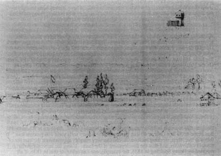
|
| Figure 2. Sketch of Fort Vancouver and part of Fort Plain, looking southwest, c. 1846, by artist Paul Kane. Original in Royal Ontario Museum, University of Toronto. |
The most logical explanation for the approximate equal size of the crops in 1836 and 1844, despite the establishment of Mill Plain Farm, is that the Company abandoned all or part of its cultivation on the West Plain Farm on Lower Plain. There is some historic evidence to support this supposition. Merchant M.T. Simmons, who arrived at the Columbia in 1844, noted that Fort Vancouver "had three farms under cultivation and fenced in; there had been a fourth, but the fences and barns had been burnt up in 1844." [427] It seems probable that the 1844 fire, which destroyed fences and structures at the West Plain Farm were never replaced, which accounts for almost two hundred acres.
In 1839, the number of cattle at Fort Vancouver doubled from the amount reported in 1838, and increasing numbers of sheep were being imported from England, as well as from California. Many head were ultimately destined to be driven to Fort Nisqually and Cowlitz Farm, as part of the Puget's Sound Agricultural Company, but occasionally weather or labor availability required that the livestock be held at Fort Vancouver for some months. It appears from the historic literature, that the additional livestock were pastured primarily on the edges of the Mill Plain farm, and on Lower Plain, although there are some references to grazing livestock on Fort Plain in the 1840s.
Fort Plain
Fort Plain was the functional and approximate geographic center of the Fort Vancouver farm. As noted earlier, all principal roads led to and from the 1828-29 stockade, making it the hub of the other farms located to the northwest, west and east of it. Until the establishment of Mill Plain farm in 1841-2, much of the Company's crops were grown on Fort Plain, and some portion of the livestock was probably always allowed to graze on it. The perimeter of the plain was bounded on all sides by dense forest. On the west, underbrush and trees separated it from Lower Plain; on the east the forest served as a boundary between it and the large natural opening which was to become Mill Plain farm. On the north, the forest ringed, and probably intruded into the upper plateau of the plain.
By 1844-46, there were a number of distinct activity centers on the plain, as indicated in the 1846 Covington farm map, by the 1844 Peers map, and by the Vavasour map of 1845. The stockade included warehouses, sales shops, residential structures, and industrial buildings; outside, to its immediate east and north, were additional structures associated with manufacturing and agriculture. Surrounding the stockade were cultivated fields planted in different crops, including a garden on its north, and an orchard to the northwest. The Company's cemetery, cultivated fields, a complex of barns--burned in 1844--and several structures associated with the stockade, including a new Catholic church and schoolhouses were situated north of Upper Mill Road, on rising ground leading to and on the upper plateau. A village consisting of somewhere between thirty and sixty dwellings--later referred to as Kanaka Village--was located west of the stockade and the "river road." Manufacturing and processing activities, some dwellings, and a hospital were located southwest of the stockade near the Company's wharf along the Columbia River. Southeast of the fort were two different cultivated fields. The remainder of the plain was apparently used to pasture livestock. Scattered across it were agricultural buildings, including barns, a stable, and a piggery.
The post was moved approximately one mile west of the original stockade, to the west side of what became known as Fort Plain, about four hundred yards from the Columbia River, in the winter of 1828-29. The site selected was apparently carefully considered, after observing the spring floods in the late '20s. There is one recorded incident of flooding during this period when the waters may have reached the stockade. Jedediah Smith said construction on the new stockade began in the early spring of 1829; by the time he left in early March, enough was built for him to report the stockade was about 300 feet square. [428] However, construction was still underway in the fall of 1829; Archibald McDonald "ventured" to the post at that time and referred to Fort Vancouver as "...being rather an unfinished Garrison." [429]
It appears that cultivation of the plain began at that time--possibly a year or two earlier, and that most of the livestock grazing on the plain, noted by John Scouler in 1825, were gradually moved to other areas of the farm. At present it is unknown when the houses or cabins for Company servants first appeared in the Kanaka Village area, but some were apparently located in the general vicinity by 1832, as reported by John Ball. In addition, there is some evidence that a small cluster of structures were located near the southeast corner of the stockade, at least as early as 1841. The beginning of the development of the river front area south of the village probably occurred at least as early as the move of the fort. Two small wooden boats were built at Fort Vancouver in 1827-28, and it has been hypothesized that two structures--boat sheds--still standing in 1846-47, just east of the pond, may have been erected in or around that time. [430]
Stockade and Associated Structures
The size of the new stockade and the number of buildings it contained expanded over the years, reaching its greatest extent in the late 1840s. By 1846, the appearance and size of the stockade had changed significantly from that of a decade earlier. [431] Later testimony by managers and employees of the Company all agrees that the stockade's interior appearance in 1846 was largely due to changes which began in the late 1830s. Chief Factor James Douglas stated "The principal buildings...existing at the time of the Treaty... [were] erected subsequently to the year 1838--as in that and the following years the old buildings were removed and replaced by other erections." Clerk Thomas Lowe said "The whole of [the buildings within the fort] with a few trifling exceptions, had been built between the years 1839 and 1844. I myself saw the principal stores put up in 1843 and 1844." [432] Manager Dugald Mactavish later said, "After 1839 within the fort the picketing fence was entirely renewed, all the large warehouses, four in number, the office, the bakehouse, the prison and the forge." [433] The structural evolution of the stockade altered its spatial configuration, circulation, and small scale elements which comprised its landscape features. Unfortunately, historic and graphic documentation of these features is scant.
The Stockade: 1829-1836
By early March of 1829 the new stockade was apparently complete enough for Jedediah Smith to observe that its dimensions were about three hundred feet square. The actual dimensions were 320 feet, east-west, and 317.7 feet north south. It was built of closely fitted Douglas fir logs, ranging from five to thirteen inches in diameter, with the larger posts apparently used at the corners of the structure. Horizontal cross pieces pegged or notched into the logs ran around the inside wall, about four feet from the top; each cross piece measured about thirteen feet in length and were mortised at the ends into larger posts called "king posts." Up until 1845, visitors estimated the stockade height as between apparently eighteen to twenty-five feet tall above grade. There was one entrance to the stockade, set approximately in the center of the south wall, 164.5 feet east of the southwest corner. [434]
The buildings within the stockade, when completed, were located along the interior edges of the fort, in a U shape, with the open end of the U along the north wall. It has been hypothesized that the first Chief Factor's house was centered between the ends of the U, near the north wall, facing the gate. Two buildings flanked the gate on the interior at the base of the U, forming a road or corridor which led to an apparently open courtyard in the center of the U. These were what is called the First Fur Store, to the west of the gate, and the first Indian trade shop, to the east. Arranged along the west interior wall, forming the west leg of the U, were, from south to north, a powder magazine, the new store, the sales shop, and a general store house. Along the east leg of the U was a carpenter's shop; a structure hypothesized to be a building serving an Indian trade shop, which included a hospital dispensary, apparently built prior to the first Indian trade shop; and a building now called the old office. Wyeth mentioned a "powder magazine of stone" when he visited the fort in October of 1832. [435] Archaeological evidence to date indicates the magazine's walls were of brick imported from England. [436] John Warren Dease noted on November 26, 1829 that: "Men building a Temp[orary] Bake house..." [437] Its location has not been determined.
Early descriptions of the stockade's interior are limited. In 1834 John Kirk Townsend said there were ten or twelve buildings "...ranged around in a quadrangular form," and that "...the house occupied by the doctor" was "in the middle." The open court in the center of the stockade was "an oblong square, of about one hundred by two hundred and fifty feet...In front, and enclosed on three sides by the buildings, is a large open space, where all the outdoor work of the establishment is done. Here the Indians assemble with their multifarious articles of trade, beaver, otter, venison and various other game, and here, once a week, several scores of Canadians are employed, beating the furs which have been collected, in order to free them from dust and vermin." [438] On at least one occasion, the court served as a round-up corral. In 1833 William Tolmie described preparations for a ride to the Lower Plain: "The square was now occupied with upwards of 100 horses & canadians were busy lassoing some for use. At 12 got all mounted & Govr., Cowie, G & self beside a large cavalcade of Canadians & boys, set out for Vancouver Plain..." [439]
Archaeological studies have established that privies were located between the buildings and the walls of the stockade, a pattern which continued throughout successive expansions. To date, a total thirty-three, apparently spanning the life of the stockade, have been found. Of these, seven may date to the earliest years of the stockade's construction; four, at least, located along the east wall of this first period, date prior to its expansion between 1834 and 1836. No privies have been located along the original south and west walls of the stockade. An 1860 Boundary Commission photograph shows what appears to be a privy along the easternmost wall of the last phase of stockade construction, indicating it was enclosed within a shed-roofed building. [440] At this time the extent of enclosure of the earlier privies is unknown.
Of the five wells uncovered to date by archaeologists, it appears from historic documentation that only one of these could have been in existence during the early period of the stockade, and its date of construction at this point has been placed later, circa 1841, since it is first recorded on the Emmons plan of 1841, and first mentioned by Lieutenant Wilkes. [441] There is no apparent reason, however, why it could not have existed in the 1830s. It was located slightly southwest of the warehouse in the northwest corner of the stockade, at the edge of the court. Its location within the court is interesting--three successive additional wells were placed near the stockade walls, behind the principal buildings, in what could be termed the "service area" of the stockade. The fourth well, which is believed to be the last one sunk, circa 1854, was located in the center of the enlarged stockade, when operations at Fort Vancouver were on the decline.
Archaeology and some historic graphics indicate that different areas of the stockade, between the buildings and the walls, were fenced throughout the period of the stockade's existence. The fencing can be dated, to some extent, from knowledge of the date of the building construction and illustrations, but this dating tends to become less reliable in the west haff of the stockade, since the exact sequence of the construction or re-construction of older buildings is not clearly understood. At present it is believed the fencing served at least two purposes: to keep any loosed livestock--such as the horses to which Tolmie referred--out of the areas in back of the buildings, and to discourage theft of any materials or provisions stored in back of the buildings. The appearance of the fencing--its style and height--at this time is not known. Fences between and behind the buildings on the west and north of the stockade may post-date this period, since the large stores and warehouses were either replaced or substantially rebuilt in the late 1830s and early '40s. Fences lining the road or path leading from the only gate of this early stockade, located near the center of the south wall, may date to this first period, since they would have served to keep any livestock driven from outside the stockade from behind the buildings, and would have discouraged access to any merchandize stored behind the fur store or trade shop, although the latter was also rebuilt or replaced in 1844.
Other small-scale elements within the stockade at this time include a belfry and a flagstaff. The location of the first flagstaff within the stockade is unknown; the second, known to exist by 1841, was located southeast of the second fur store, on the south side of the stockade: it is believed to date to the time of the stockade's first expansion east, circa 1834, since it would have then been positioned near the center of the enlarged stockade. [442] It is depicted in drawings of the 1840s as a simple one-piece mast. A bell served to signal work times, church services, and other daily and weekly activities. The existence of a belfry in the 1830s is well-documented, but its location, at present, is unknown.
The post was still under construction in September, 1829, when John Warren Dease, in charge of the Fort Colvile District, arrived at the fort seeking medical treatment. [443] He noted on September 6 that he "Got my tent pitched there being no house room: all the gentlemen being in lodges or tents." Towards the end of October he finally procured a room in a "twenty-foot square house, which he shared with two other Company officers, "Not a shelf or bench yet in my house nor the gabled end finished." On November 11 Dease recorded, "Here I am in a room half finished, as cold in night as out of doors." By this time, however, Dease was apparently suffering from McLoughlin's disfavor, and, despite his illness, on November 30, wrote "Chief Factor McLoughlin seems determined not to get my room arranged though the rain drops in it and wind comes through in every quarter." [444]
The location of this twenty-foot square structure is unknown at present: known structures within the stockade up to 1836 did not apparently include any living quarters other than those in the Chief Factor's house. However, in 1832 George Allan noted "The Fort itself is surounded with high stockades and consists of a Governor's house, stores, an office and houses for the gentlemen who conduct the trade." [445] Also, in 1833, Dr. William Tolmie and Dr. Gairdner were assigned quarters in the Apothecaries Hall, which adjoined the "schoolroom" on the north and an unoccupied apartment to the south. When he described, in some detail, the interior of his quarters, he noted that a partition was to be built to create a front room which would be the surgery. From his description, it appears that his apartment could have been in the building noted as the earliest Indian trade shop, or the "first store," on the east leg of the U. [446]
Two successive Chief Factor--or Big House, as they were referred to by employees-residences existed within the stockade; the first, probably located in the general vicinity indicated above in the original portion of the stockade, and the second built after the stockade was expanded to the east in 1834-36. It is the second house which has been reconstructed and stands within the Park's stockade today. Apparently the first Big House was disassembled and moved from the original 1824-25 stockade on Old Fort Hill to the new stockade sometime in the fall of 1829: John Warren Dease noted in his journal October 9, 1829, "Began to put up the posts of the big house..." [447] The exact location of the first house has not been determined with certainty; it is believed to have been demolished when the new one was completed in 1838. It is believed missionaries Cyrus Shepherd and Jason Lee were given housing in the Big House after their arrival in September of 1834. Lee noted, "...our baggage was brought and put into a spacious room without consulting us and the room assigned for our use..." [448] Sheperd's diary says "...a large convenient room was prepared for the reception of ourselves and our effects." [449]
The Stockade: 1834-1841
Between 1834 and 1836 the stockade was enlarged, and during and following that period, new buildings were erected in the interior. W.H. Gray, who arrived with the Whitmans in 1836, later recalled: "The old fort was so much decayed that the new one was being built and portions of the old one replaced." [450]
The dimensions of the stockade until the early 1840s, according to archaeological studies of the site, were 660.75 feet, east-west, by 317.7 feet, north-south. The west wall was rebuilt 23.5 feet west of the original stockade's west wall; the east wall was extended 317.25 feet east of the original wall. Two new gates were built in the stockade walls at this time: a second gate on the south, near the southeast corner, measuring 10.75 in width, was built, and a gate which probably measured around twelve feet in width, was erected on the north, 212 feet from the stockade's northeast corner. [451]
Visitors to the fort during this period give varying dimensions for the stockade, although they all indicate the stockade was at least doubled in size. The Rev. Samuel Parker said in October of 1835 that the "strongly stockaded" enclosure was thirty-seven rods long and eighteen rods wide, (297 by 610.5 feet). Parker was a careful observer: perhaps his report pre-dates the first expansion of the stockade to the west. [452] John Sinclair reported in April of 1838: "The principal buildings are enclosed by a picket forming an area of 750 by 450 feet." [453] Captain Edward Belcher, who visited in 1838, reported some puzzling dimensions: "...it is a picketed enclosure three hundred yards square, the pickets being 18 feet high, composed of roughly split pine longs...It is furnished with three gates, two of which are invariably opened by day..." [454] In 1839, Catholic priests who arrived at the post in late 1838, Frs. Modeste Demers and Francois Norbert Blanchet, noted the fort "...is a parallelogram of one arpent in width by several arpents in depth surround by stakes of something like twenty feet in height...The gates are closed every evening for the safety of the goods on deposit there..." [455] Thomas J. Farnham, also at the depot in 1839, said: "The fort itself, is an oblong square, 250 yards in length, by 150 in breadth, inclosed by pickets, twenty feet in height." [456] George Foster Emmons, who arrived with the Wilkes expedition in 1841, drew the first known plan of the stockade's interior in July of 1841; he estimated its size at four hundred by seven hundred feet. [457]
The Emmons plan shows the interior at that time was divided into two large open spaces by buildings which edged the original stockade's east wall. The courtyard of the original stockade was to the west, and a slightly larger courtyard, enclosed on the north, east and west by new buildings, was to the east. At that time, the c. 1829-30 buildings--the "old" office, the "old store", converted in 1838 or '39 into a Roman Catholic chapel, and the carpenter's shop--now served to divide the enlarged space into two distinct areas. Captain Edward Belcher said in 1838: "Houses of residence, as well as storehouses of the company are within this enclosure, forming two squares." [458] In 1839, Farnham said the stockade's interior was "...divided into two courts, around which are arranged thirty-five wooden buildings, used as officers' dwellings, lodging apartments for clerks, store-houses for furs, goods and grains, and as workshops for carpenters, blacksmiths, coopers, turners, wheelwrights, &c." [459] It is probable that at this time, the new south gate, to the east, became the principal or formal portal to the stockade: various visitors noted that upon entering the stockade, the Chief Factor's house, located across the east court, was in view, and the Indian trade shop was immediately to the right after entry through the gate. The original gate to the west led to what became primarily a warehousing precinct, and seems likely, both functionally and for reasons of security, to have been a secondary service entrance.
John Sinclair reported in April of 1838: "Within the pickets there are 34 buildings of all descriptions, including officers' dwelling houses, workshops for carpenters, blacksmiths, wheelwrights, coopers, tinners, and etc., all of wood, except the magazine for powder, which is of brick. [460] This count does not tally with the map prepared by Emmons in 1841, which shows nineteen structures--although one of these was actually two separate buildings, making a total of twenty. In 1839 Frs. Demers and Blanchet noted the existence of "...dwellings of the gentry, the storehouses, sheds, a blacksmith shop, a number of lesser buildings..." [461]

|
| Figure 3. 1841 illustration of Fort Vancouver stockade and portion of Fort Plain looking northeast, by Henry Eld, who was with the U.S. Exploring Expedition commanded by Charles Wilkes. Original from Henry Eld, "Journal, Statistics &c. in California and Oregon," Beinecke Library, Yale University. |
Thomas Farnham, also at the post in 1839, described the activity within the stockade:
The blacksmith is repairing ploughshares, harrow-teeth, chains and mill-irons; the tinman is making cups for the Indians, and camp-kettles &c.; the wheelwright is making wagons, and the wood part of plough sand harrows; the carpenter is repairing houses and building new ones; the cooper is making barrels, for pickling salmon and packing furs; the clerks are posting books and preparing the annual returns to the board in London; the salesmen are receiving beaver, and dealing out goods... [462]
It is possible that some smaller sheds and activity areas which both the priests and Farnham allude to, and which Sinclair apparently counted as separate buildings, were attached to or encompassed by the larger buildings noted on Emmons 1841 map. It is also possible some or all had been demolished by 1841.
In March of 1838 Herbert Beaver noted that "The state of the buildings is altogether most pauperized both in appearance and reality; and though a new great house has been lately built, and is now inhabited, the old one has been dismantled so that very little more accomodation exists." [463] At least twenty structures were located within the stockade at the time Emmons drew his plan in 1841. New buildings known to have been built during this period, included the chaplain's kitchen/schoolhouse (1836-38); a residence called the Priests' House (1837-38); a new bakehouse (the "second" bakehouse); a wash house (c. 1841); a new blacksmith's shop, in the southeast corner (1836-41); a new store, the "Missionary Store" (1836-41), later serving as the second Indian trade (sale) shop; [464] a dormitory referred to as the "Second Bachelors' Quarters (1838);" and the new, or second, Chief Factor's House, or "Big House" (1837-38), with a separate kitchen to the rear (1837-38). These structures were all located in the area encompassed by the stockade expansion to the east. In addition a granary, or wheat store was erected in the winter of 1838-39 near the north wall in the older section of the stockade, east of general storehouse #18, to accommodate the increasing amounts of wheat and other grains produced on the farm and purchased from the Willamette Valley. Among the larger buildings," Samuel Parker noted in 1835, "there are four for the trading department. One for Indian trade, in which are deposited their peltries; one for provisions; one for goods opened for the current year's business, that is to sell to their men and to send off to various fur stations; and another for storing goods in a year's advance." [465] These four buildings were apparently the older structures on the west and south edges of the original enclosure. To date it is known that two earlier buildings had been demolished: the first Big House, and the first priest's house or parsonage, in which the Beavers lived, which gave way to the larger Priest's House noted on the Emmons plan. In addition, the former store in the center of the court was converted around 1838-39 to a Catholic church.
Information regarding the small-scale elements and materials of the courts is scant. Captain Belcher said that in 1838: "In the eastern square the main building is occupied by the chief...In front of the steps of this building are two long twenty-four pounders ship guns and two short merchant cannonades twelve or eighteen pounders...on the left, at right angles, are the quarters of the other clerks, traders, etc." [466] Frs. Demers and Blanchet's report of 1839 noted, in apparent reference to the new courtyard: "...a rather extensive courtyard, where one sees four cannon serving as a means of public elucidation for those who have made themselves guilty of some offence." [467] In 1841, Wilkes said: "...At one end is Dr. M'Laughlin's house, built after the model of the French Canadian, of one story, weather-boarded and painted white. It has a piazza and small flower-beds, with grape and other vines, in front. Between the steps are two old cannons on sea carriages, with a few shot, to speak defiance to the natives, who no doubt look upon them as very formidable weapons of destruction...In the centre stands the Roman Catholic chapel, and near by the flag-staff; beyond these again are the stores, magazines of powder, warerooms, and offices...All is arranged in the best order, and I should think with great economy." [468]
Of the known privies, six were found located along the new east stockade wall, bracketing their dates between 1834 to '36 and 1841 to '44, when the east wall was again moved further out. Three privies have been found along the new north wall of the expanded stockade, and one along the south wall, placing their date of construction after 1834-36. Most of these were located behind residential buildings--the bachelor's quarters (1838) and the new Chief Factor's house kitchen (1837-38). The others were behind the building serving as the chaplain's kitchen and schoolhouse (c.1836-38) during this period, and associated with the priest's house (1837-38); the missionary store (1836-1841), in which it appears the post doctors and other officers lived periodically; and in the northeast corner near the second bakehouse and the wash house. [469] At this time, it appears the well reported by Lieutenant Wilkes and recorded by Emmons, located in the northwest corner of the old court, was still in use.
As noted earlier, a second flagstaff, known to have existed by 1841, and confirmed archaeologically, was situated near the south stockade wall, in the approximate center of the enlarged stockade, southeast of the first Indian trade shop. Another flagstaff, located archaeologically, was found in front of the second Chief Factor's house, located just north of the fence enclosing the front of the house, and positioned in the approximate center. Its construction date has been hypothesized as close to the time of the construction of the house, 1837-8; it does not appear in the map or illustration by Vavasour and Warre of 1845, nor in the 1846-47 painting attributed to John Mix Stanley. The belfry during this period was one pre-dating a new one erected in 1844; its location is unknown.
As during the 1829-31 period, fences were built between the backs of buildings and the stockade walls, and various maps have indicated a number of fence lines. Dating is somewhat problematic, as has been noted earlier, but it is generally assumed that the fences date to near the construction date of the buildings to which they were attached. As mentioned previously, the fences which ran between the buildings on the west edge of the stockade are difficult to date, owning to the uncertainty of the construction sequences, although whether rebuilt or renewed, construction activity appears to date to 1844-45. Along the north wall, it appears a fence enclosing a space behind the chaplain's kitchen/schoolhouse may date to the time of its construction, 1836-38; a fence extending from the northwest corner of the Chief Factor's house may date to the same period. These fences would have lined the road leading from the north gate into the stockade, and replicate the pattern established by the fences at the southwest gate, directing traffic to the court interior. Along the east stockade wall, there were two fences enclosing the area behind the bachelor's quarters, one at each end of the building, which may date to its construction in 1838, and a short span of fencing extending from the northwest corner of the wash house (c. 1841) to the second bakehouse (1837-38). On the south, fences enclosed the area behind the first Indian trade shop, which may date to its construction (1836-41). In addition, a fence enclosed a garden in front of the Chief Factor's house; it has been located archaeologically, and a picket fence can be seen in the 1860 Boundary Commission photograph of the building. This enclosure is presumed to date from the time of construction of the building, 1837-38.
The surface material of the courtyard, and the circulation patterns during this period are unknown. However, one resident's comments seem to indicate the stockade's interior was, essentially, dirt. By now quite soured on Fort Vancouver, Herbert Beaver wrote in March, 1838: "Besides, from the water, which has surrounded our home, and the mud caused by the Pigs and Carts, by which the ground around it is perfectly ploughed up, the one who remains there, has become a complete prisoner the whole winter...now, buried,as we are, amidst the store-houses and palisades, we can see nothing but the sky, nor feel a breath of fresh air during our sultry summer." [470]
Most of the buildings in the fort at this time were, according to Emmons, "...wood, generally hewn logs, like the universal log Houses of Canada." [471] Wilkes said, "Besides the store-houses there is also a granary, which is a frame building of two stories, and the only one, the rest being built of logs. [472] Emmons, on July 25, 1841, noted of the stockade, "Nearly all the posts are more or less decayed at the surface of the earth, and will soon require replacing by others." [473]
The Stockade: 1841-46
During this period, the stockade reflected the development of the depot when the Hudson's Bay Company, through Fort Vancouver, had reached its maximum influence in the region. Dugald Mactavish later stated that in 1846, all the buildings were "in good order" and were "substantial." He noted that, "Besides trade with Indians, considerable trade for supplying the settlements on the Willamette Valley, for Agricultural operations alone, the place was larger than necessary." [474] Joel Palmer, who visited the fort in 1845-46, noted: "Many buildings are large and commodious and fitted up for an extensive business, others are old fashioned looking concerns, and much dilapidated..." [475]
The stockade during this period measured 732.8 to 734 feet east-west, and about 318 feet north-south. Two features of special significance mark this period of stockade construction: the bastion at the northwest corner of the stockade, on which construction was begun in February of 1845, and the post's third bakehouse, which was completed late in 1844. The bakehouse is notable because it helps to date the expansion of the stockade, since the building extended both east and west of the stockade's east wall, and was apparently built--or begun--when the wall was shifted 57.75 feet to the east. It appears the west wall was shifted about 16.3 feet west in January or February of 1845, when the bastion in the northwest corner of the stockade was begun. [476]
Visitor observations of the fort differ when reporting the size of the stockade. Eugene Duflot de Mofrás, who worked for the French government and was at the post in October of 1841, said the stockade was "240 meters wide and 130 meters deep," or about 787 by 426 feet. [477] Lieutenant Mervyn Vavasour, who along with Lieutenant Henry Warre was evaluating Hudson's Bay posts for the British government in 1845, reported the "...picket fence 15 feet high and 226 yards by 100 yards; at the N.W. angle there is a 3 storied blockhouse, 20 feet square, the two lower stories are loop-holed, the upper is an octagonal cap containing eight 3 Pd. iron guns." [478]
Because the de Mofrás estimate is at variance with the archaeological evidence regarding the ultimate size of the stockade, it is difficult to pin down the exact year of the stockade's second expansion to the east. Emmons had noted in July of 1841 that the posts were decayed and would soon require replacement, however, it appears the bakehouse's construction was simultaneous with the new east stockade wall, and its construction history tends to suggest it was built in 1844. [479] Dugald MacTavish, stationed at the post in the late 1830s and 1840s, and later a manager of Fort Vancouver said "The stockade was renewed in the autumn of 1842 and by the spring of 1845 the entire enclosure had been renewed." [480] His description of procuring timber for the stockade--selection of logs "at a great distance from the fort," rafting them down river, and hauling them by oxen to the site--implies the construction continued over some time. Millwright William Crate later testified that rebuilding began before he left the post in 1843, and that when he returned in 1849, "...many of the buildings had been rebuilt, and most of the stockade and all the buildings had been put in first rate repair." [481]
The rebuilding program continued during this period. New structures included the aforementioned bakehouse and the northwest bastion, under construction in February of 1845. A new storehouse--"The Beef Store"--was built on the site of the earlier one-story general storehouse #18, by 1845, where it shows on Vavasour's plan of the stockade, and probably several years earlier, to accommodate the storage of beef processed from the now large numbers of cattle stocking the farm. An iron store was erected in the southeast corner, east of the second blacksmith's shop, after the east stockade wall was moved, between 1844 and 1845. The earlier general store house #17, in the northwest corner of the stockade, was demolished by 1845, and a root house constructed on its site, possibly as early as 1846.
The chaplain's kitchen/schoolhouse was converted to use as a church--The Owyhee Church--during this period, although it is believed to have continued to be used as a schoolhouse as well. The building housing the second bakehouse in the northeast corner of the fort was either torn down and replaced with a new structure, or was converted to use as a harness shop after the new, "third bakehouse," was completed to its east in 1844. In addition, the Big House, or second Chief Factor's house, underwent repairs, where the gallery was replaced in May of 1845. [482]
The four storehouses on the west and south edges of the older courtyard were probably all torn down and rebuilt during this period; as noted earlier, several witnesses testified to their replacement or renewal. It is known for sure that the storehouse in the southwest corner, was replaced by the "new store" in 1844, where Thomas Lowe makes reference to its construction in his journal. It appears that the building to its north, the general store house, was also torn down and replaced by a new "sale shop" in 1844-45. The two structures were connected on the second story by a catwalk, which spanned the space between them. Some time between 1841 and 1844, the fur shop was moved from its original location in the building east of the powder magazine to a building immediately to its east. This latter structure was either a new building on the site of the first Indian trade shop, or a substantially rebuilt structure. On the site of the first fur store, a new building was erected, which was called the "provisions" store. The Indian sale shop functions were moved into a building erected between 1836 and 1841 on the south edge of the east court; this building was previously referred to as the "missionary store" or shop.
During this period, the spatial organization of the interior was altered by the removal of the old buildings which had been located along the east wall of the original stockade, and which had served to divide the yard into two courts. The first carpenter's shop was either demolished or moved to a site almost due north of its original location, along the north stockade wall; by 1844 the shop was located in a structure on that new site. The Catholic church was demolished in June of 1846, just after the new Catholic church outside the stockade was dedicated. The last building dividing the two courts, the "old office," was left standing, although construction of a "new office" had begun in August of 1845. The "new office" was occupied by Captain Baillie, commander of the Modeste, which apparently forestalled removal of the old office, which continued in use until the Modeste left Fort Vancouver. [483] It can be seen in the first known illustration of the stockade's interior, executed by Lieutenant T.P. Coode, in 1846-47, and both offices are listed in the 1846-47 inventory of buildings prepared by the Company.
Of the interior of the stockade, in late 1841 de Mofrás reported, "The enclosure contains thirty separate buildings. These include quarters for the governor, the superintendent, and other employes of the Company, together with their families, carpenter, locksmith, and blacksmith shops, forges, storehouses for furs, tanneries, a warehouse for European merchandise, a pharmacy, and a Catholic church that also serves as a school. All of these buildings are constructed of wood, except the powder magazine which is an isolated brick structure." He also noted "...two antiquated iron cannon that have been spiked, which stand in the center of the quadrangle." [484] In 1845, Vavasour said, "The establishment contains several large stores houses, made of squared timber, small stone powder magazine and several framed dwelling houses..." He noted in an addenda, dated November: "Number and description of Buildings: 6 large storehouses, 4 dwelling houses, bakehouse, blacksmith's shop &c. &c. affording accomodation for about 500 men." [485]
From Lieutenant Coode's 1846-47 watercolor, it appears that the west end of the central court, at least, was devoid of any vegetation other than the grapevines growing in front of the Chief Factor's house. The grapevines, according to Dugald Mactavish, were "...bearing fruit and of some value." [486] In the Coode illustration, a path encircled the yard, running within yards of the entries to the buildings ; it is difficult to tell the nature of the path's materials, but in the watercolor, it appears simply to be a well-worn dirt surface, distinguished only from the center of the court by a change in color and texture. It is impossible, also, to determine the nature of the material of the center court; perhaps it was grass. The next available close-up views of the stockade's interior are three taken by the British Boundary Commission Party in May, 1860, showing the northeast and northwest corners of the court, and the Chief Factor's residence. British North West Boundary Commission Survey Due to the grainy nature of the black and white photographs, it is difficult to determine the composition of the yard's surface. In the photo of the northeast corner, two small trees can be seen behind the tents, one just west of the granary, and one north of the sale shop. It is unknown when they were planted--if they were deliberately planted, and not volunteers allowed to grow as maintenance slipped, and the old office in the 1846-47 Coode drawing blocks the view of their location.

|
| Figure 4. Hudson's Bay Company stockade interior, 1846-47, looking west. The illustration shows a path around the edges of the courtyard, grapevines on Chief Factor's House (far right), belfry and flagstaff, and the Old Office jutting into the open space of the courtyard, prior to its demolition. Copy of a watercolor by Lt. T.P. Coode. Original in Hudson's Bay Company Archives. |
The circulation pattern within the stockade during this period is also not clear, but a later U.S. Army map shows a network of paths which may have been in existence during this period. [487] The 1860 Boundary Commission photograph of the northwest corner of the stockade interior shows what appears to be a planked walkway or road leading, apparently, from the southwest gate to the center of the yard, where it abruptly terminates. To date, it is unknown when this was installed, or for what purpose. [488] The probable remains of a planked road, eight to ten feet wide, and approximately 70 feet long, running between the the second fur store and the provisions store were found in association with a drainage system by archaeologists Hoffman and Ross in 1974, which may place the date of the road around 1845. [489]
It appears that at least three wells--probably four--were used during this period. Within the stockade, it appears the wells were used in succession. As noted earlier, Charles Wilkes reported--and Emmons drew--the earliest known well to date in the northwest corner of the west court. It was in use at least during their visit, in the spring and summer of 1841. When Lieutenant Mervyn Vavasour of the Royal Engineers and Lieutenant Henry J. Warre of the Fourteenth Regiment arrived at the post late in 1845, Vavasour recorded another well north of the beef store, between it and the north wall of the stockade. He also recorded another well, located east of the wash house, in the northeast corner of the fort, beyond the 1834-36 east wall of the expanded stockade. This well's construction was documented by clerk Thomas Lowe, who noted it was being dug in February of 1845. [490] What appears to have been a fourth well, recently detected by archaeologists, was located just outside the north wall of the stockade, in the approximate center of the south edge of the garden; it is presently assumed the well was for garden use, and its construction date is unknown. As noted earlier, the above-ground appearance of the wells not known at present.
In December of 1844, a new belfry was erected, north of the site of what would become the location of the new office, begun in August of 1845. Clerk Thomas Lowe recorded that the bell was located "at the top of a spar 45 feet above the ground." [491] The base of this structure has been located archaeologically, and can be seen in the 1847 Coode watercolor of the stockade's interior. By 1855, however, a new belfry had been erected just south of the east-west center line of the stockade, in the approximate middle of the court; it can be seen on illustrations from that period, and in the 1860 boundary photographs of the stockade's interior.
Of the privies known to have existed, one has been found near the new west wall of the stockade, northwest of the sale shop, and therefore dates to after 1845. Eight have been found on the edge of the new east stockade wall, six of them east of the bachelor's quarters. Some of these clearly date to the time of the construction of the new east wall, but some could have been erected in the late '40s and throughout the '50s as well.
If, as it appears, the sale shop and new store were both new structures built in 1844 and 1845, then the fences which extended from them on a north-south axis probably date to this period. Two fence lines extending from the beef store to the north stockade wall, enclosing the "second well" shown on the 1845 map, were probably also erected during this period. Fence lines extending east to the new stockade wall from existing fences on the east corners of the bachelor's quarters may also date to this time.
Structures Associated with the Stockade: 1829-1846
The Gate
The 1846-47 painting attributed to John Mix Stanley shows a heretofore unremarked upon structure of some significance to the landscape organization by the Company. It appears to be a gate, comprised of two vertical posts and a horizontal beam, shown on the painting to the right (west) of the bastion. From its position within the painting, it appears to have been sited with the beam running north-south, across Lower Mill Road, on the east side of the intersection of Lower Mill Road and the "river road". The painting is generally considered a reliable and detailed representation of the stockade vicinity, or at least the stockade proper, and it seems unlikely the illustrator would have taken artistic license with a feature so far back in the painting. The location of a gate at this intersection is highly credible: it would have marked a formal entry to the stockade environs on the route most traveled by everyone visiting the stockade. Lower Mill Road, the principal road to the stockade, and the main gate--later gates--were located on its south side. The Lower Mill Road was also the principal access from the heart of Kanaka Village to the stockade, at least in the mid-40s, as shown on the 1844 Peers map and the 1845 Vavasour map. What appears to be the same structure can barely be seen on the 1846-47 Paul Kane sketch of the site, drawn from approximately the same angle as the painting attributed to Stanley. Unfortunately, no other maps or drawings preceding, during or after this period indicate a gate in this location. Nevertheless, it appears that a gate probably existed in this location in the mid-1840s.
Exterior of Stockade's Southeast Corner
There is little reference in the historic literature to buildings known to have existed beyond the stockade's southeast corner. However, both period illustrations and archaeologic investigations indicate at least a small cluster of structures existed in this location, dating back to at least 1841. What appear to be the cellars of several buildings have been found beyond the southeast corner of the stockade prior to its expansion east between 1841 and "44, and within the later east picket wall.
Three buildings outside the southeast corner, in an east-west row can be seen in the drawing by Henry Eld of the U.S. Exploring Expedition, at the fort in the spring and summer of 1841. Two can be seen in a sketch by artist Alfred Agate, also with the Expedition. Three structures are also illustrated on the 1844 stockade area map, after the expansion east, but the size of the structures do not appear to correlate with Eld's drawing. The watercolor and lithograph by Lieutenant Henry Warre, in 1845, also show three structures. Three buildings are also illustrated in the 1846-47 sketch by Paul Kane and the 1846 Covington stockade area map, and the edge of one building can be seen in the 1846-47 painting attributed to John Mix Stanley. Of these, the Kane and Covington graphics seem to agree best regarding the approximate size and siting of the three buildings, with a larger, gable-roofed structure nearest the stockade wall, and two smaller buildings to its east. The 1846-47 painting tends to support the image of a larger sized structure nearest the wall. The Warre drawings and the Kane sketch seem to indicate that this larger buildings was in fact two gable-roofed structures sharing a common wall, with a smaller building to the east slightly set back from the east-west alignment. The third, easternmost building shown on the later drawings is not visible in the Warre sketches. In the 1844 stockade area map, the larger building appears to be illustrated, but the two structures to the east of it are not equal in size--if the scale is correct, the structure just east of the larger building appears to be no larger than the wash house within the stockade. In the Eld drawing of 1841, the largest of the three buildings appears to be the middle structure. In the Agate drawing, two structures are visible, the nearest of which appears to have a hipped roof.
The larger building is identified on the 1846 Covington stockade area map as the "cooper's shed;" the 1846-47 inventory of buildings listed a coopers shop, 70 by 30 feet, and later testimony by Henry Tuzo, at the fort beginning in 1853, testifies to the location of a "large cooper's shop" outside the stockade to the east. [492] According to historian John Hussey, the cooper's shop was situated in this building at least by 1846, and possibly as early as 1841. There is some question as to which of the buildings shown on the Eld and Agate drawings--if any--was this building, since both drawings show the buildings at a distance at a small scale and their execution was made prior to the expansion of the east stockade wall. Archaeological investigations have identified structural remains which could be the west foundation of the cooper's shop, and a privy in the area was also uncovered. Since excavation of the remainder of the area was not done, it is not possible at this time to positively identify the location of the shop. [493]

|
| Figure 5. Fort Vancouver stockade looking northwest in 1845. Based on sketches made by Lt. Henry Wane, this lithograph shows fenced fields south and north (on the rising ground) of the stockade, and the cooper's shop and associated buildings just outside the southeast corner. Original from Henry Wane, Sketches in North America and the Oregon Territory. |
The other structures, if they ever served any other purpose, were, by 1853, used as dwellings, according to Tuzo. [494] Archaeological investigations have uncovered one pre 1841 structure within west of the expanded 1841-44 east stockade wall, and a large quantity of domestic and personal artifacts tend to indicate that the building was used as a dwelling. In 1991 readings with a magnetometer identified other patterns of subsurface anomalies which may indicate additional building sites in the area. [495] An 1860 army board inventorying the post noted the existence of four "hovels" near the southeast corner of the stockade, and the associated inventory map shows three small buildings in an east-west row, and one perpendicular to the row on the east. [496]
As noted above, archaeologists have found one privy in this area. In addition, the Warre illustrations of 1845 show what appears to be a three or four foot tall fence, extending from the southeast corner of the stockade to the southwest corner of the building identified as the cooper's shop. It also shows a very low fence which appears to extend east from the northeast corner of the cooper's shop, and continue north, to at least partially enclose the front "yard" of the structure immediately east of the shop. An enclosure of some nature around dwellings on the farm is not unprecedented--several buildings north of Upper Mill road, and within Kanaka village have been illustrated as being placed within enclosures, presumably to keep out wandering livestock. The reason for the difference in the height and apparent construction of the two visible fences is not known; perhaps the taller fence enclosed an area in which valuable cooper's material was stored, and was erected to keep out not only livestock, but thieves.
Root Houses
From its inception, managers at Fort Vancouver planted and harvested hundreds of bushels of potatoes, which were a staple in the rations for the employees. The location of the storage buildings for potatoes--those for rations "for the men" and for seed for the following year were stored, according to the Rev. Herbert Beaver--up until 1844 is not known. In September of 1844, however, Thomas Lowe recorded that "Another gang of men [is] employed building a new potatoe cellar at the upper end of the back road." [497] The reference is almost certainly to the north gate road, which terminated at Upper Mill Road. The 1844 stockade area map shows a structure in the northwest corner of the field north of the stockade and east of the north gate road, almost certainly the potato cellar referred to by Lowe. The 1846-47 inventory lists three root houses as outbuildings, each apparently 60 by 20 feet. [498] Their location can only be confirmed as somewhere on Fort Plain from the listing, although at least one was the building north of the fort described by Lowe. This building and a second one to the east of it are seen in the 1846-47 painting generally believed to be by John Mix Stanley, which clearly shows two gable-roofed structures, with their ridges running north-south. The 1846-47 sketch by artist Paul Kane also shows what appears to be these same two structures. The function of the easternmost building is unknown, although at present it is believed to be one of the other two root cellars listed in the inventory. Unlike the garden summerhouse, which can be seen on sketches as late as 1855, these structures are not shown on any maps or in any sketches after 1846-47; they are absent from the 1851 Gibbs sketch, and from all early 1850s army maps.
North of Upper Mill Road
The development of the ground rising north of the stockade to the upper plateau appears to have been gradual. The earliest known image of at least part of the area is that prepared by Henry Eld, with the U.S. Exploring Expedition, in 1841. This drawing, looking to the northeast across the stockade, shows open ground rising behind the fort, terminating in a forest of firs and other trees; no structures are depicted on the sketch, but it appears this may have been artistic license to provide a backdrop for the center of interest, the stockade. Following this illustration are both 1844 Line of Fire maps--the Peers map and the stockade area map--the Henry Warre sketches and Mervyn Vavasour map of 1845 and the Covington maps of 1846. The 1846-47 Kane sketch shows a portion of this area in the foreground of his sketch, as does the 1846-47 painting attributed to Stanley. The next available views of the site start in 1851, with a sketch by George Gibbs, followed by lithographs and sketches of 1854 and 1855, and army maps of the 1850s.
It is evident part of the upper plateau of Fort Plain was a naturally occuring open space, from a statement by William Tolmie, who noted that the cemetery was located in "fertile upland meadow greatly beautified by wild flowers & trees in flower." [499] The upper plateau was shown in 1850 illustrations as still ringed with undergrowth and forest. The extent to which the Company cleared the land on the upper plateau is unknown; later illustrations depict large, scattered fir trees on what was to become the army garrison's parade ground, and fairly dense low-growing trees in the area below it and west of the road to the Back Plains, extending as far as the Catholic church. What appears to be low forest and undergrowth falls even closer to Upper Mill Road to the west of the church, as depicted on the 1855 Covington sketch of the site. An oak grove stood for a number of years northeast of the Catholic church; it was remarked upon by William Tolmie in 1833, as a "pretty grove of young oaks," and was still noted on army maps in the 1870s. The cemetery site in the 1840s must have been cleared, to some extent, by the Company; by the mid-1850s it was depicted as ringed by trees and containing undergrowth and small trees within its boundaries, the latter possibly due to lack of maintenance.
Both the cemetery and some cultivated fields were in existence north of Upper Mill Road by 1833. The earliest known structure located north of the road was a horse and oxen-powered gristmill, built around 1828, and still standing in 1846. The sequence of building development in this area is somewhat sketchy; by 1846, a number of buildings were located along, or slightly set-back from the road.
It appears that this area's development began with agriculturally-related features, such as fields, the gristmill, and probably storage barns. By the mid-1830s some dwellings may have been built, associated with and just north of Kanaka Village. By the mid-1840s, a new wave of development included construction of a church and schoolhouses. These sequential waves of development appear to have augmented, rather than supplanted, the uses of the site as the years passed. The change in building types may have had some relationship to the development of the road itself; it was almost certainly in existence as some sort of path and wagon road to the east, prior to 1841, as it would have been needed to access the fields east of the future site of the schoolhouses. It must have assumed much greater importance and probably underwent some improvements when the Mill Plain Farm was established in 1841. The road's development to the west probably underwent a gradual transformation from rough path to wagon road, as described by William Tolmie in 1833. As the dairy and piggeries on the Lower Plain Farm and the cultivation of the West Plains Farm developed, the road would have assumed increasing importance. By 1841, according to merchant M.T. Simmons, "...the roads were good from the fort to each of the farms; they were good wagon roads." [500]

|
| Figure 6. This later (1855) sketch by Richard Covington of Hudson's Bay Company and U.S. Army buildings shows the Hudson's Bay Company's cemetery (left, mid-ground); St. James Mission (left, foreground); one of the Company's schoolhouses (Beyond St. James Mission); the Company's garden and orchard, and early Vancouver Barracks structures (upper left). |
By 1845, a road may have been located between the intersection of Upper Mill Road and the "river road", and the road to the Back Plains; as shown by Vavsour in his 1845 map, this road ran on a diagonal towards the northeast, and connected to the Back Plains Road just north of the schoolhouses. It may have been established to provide a more direct line from the intersection to the Back Plains, and to avoid the awkwardness associated in passing by the schoolhouses, which the 1844 stockade area map and the 1846 Covington stockade area map show as located within the Back Plains Road path. [501]
Cultivated Fields
In 1833 William Tolmie, en route to a walk on Fort Hill, said there was "...farm steading which is extensive & placed about 300 yards behind & above fort." [502] This reference is almost certainly to the fields shown in the 1844-46 maps and in the background of the Warre drawing of the stockade, north of Upper Mill Road and north and east of the fort. The 1844 stockade area map shows a fenced field of Tares east of the schoolhouses, then under construction. From the scale on the map, it appears the field, roughly a trapezoid, measured about 300 yards along Upper Mill Road, and about 150 yards on its west edge, containing perhaps between 7 and 10 acres. Just east of this field was a complex of barns, in which a threshing machine was located, on a site of about two or three acres.
Both the 1845 Vavasour map and the 1846 Covington farm map show the area of cultivation had expanded beyond what was depicted on the 1844 Peers map; the Vavasour map indicates the field was expanded both north and east of its original boundaries, and that it was fenced, and the Covington map shows fields extending along the southern bluff of Fort Hill in a narrow strip. It has been postulated that the easternmost of these fields were cultivated from early in the farm's development, but the 1844 Peers map does not indicate this, and descriptions of the fire say the area was covered with grass, which was ploughed during the fire to provide a fire break. James Douglas said, "I returned to the Fort, and on Friday morning had casks of water carted out and placed along the woods on Old Fort Hill, and by half past ten we had completed a protective line round the North and East sides of the Plain, by drawing furrows with the plough fifty feet apart and burning the grass on the surface between them, trusting that it would assist greatly, as it afterwards did, in checking the progress of the fire." [503] Thomas Lowe recorded "Most of the men were employed all morning about the Fort Hill, setting the grass on fire, ploughing the ground, and taking other precautions to prevent the fire running when it emerged from the woods." [504] In addition, the 1844 Peers map shows that the area east of the barns was "ploughed and burnt for protection."
It appears that the fields east of the tare field, shown on the Vavasour and Covington maps, were planted after the fire, taking advantage of the ploughing and burning that had been done in a vain attempt to protect the barns. The 1845 illustrations by Warre of the south side of the stockade show what appear to to be the former tare field in the background, on the rising ground. In these graphics, the field is divided by a series of three rail or pole fences running north-south down the hill. The type of crop or crops planted in these fields by the Company until the 1850s, other than the tares noted in 1844, is unknown; an 1850s army map indicates that one of the fields, east of the original tare field, was planted in oats.
It is not known when the meadow to which Tolmie referred--later the site of the army garrison parade grounds--was put into production; apparently it was some time between 1833 and 1849. In 1839 James Douglas reported that "Every acre of land about the place that could bear cropping was put under seed" and that ten acres of "oak land" was cleared for planting the next season. [505] There is no way of knowing where, on the vast acreage within the farm, studded with oaks and firs, the ten acres were located, but if all possible land was in fact cultivated, as Douglas states, it would seem the meadow on the upper plateau must have been put into production in or before that year. Also, it is known from Tolmie and from later army maps that an oak grove was located just south of the meadow. Unfortunately, none of the maps from the mid-40s, with the possible exception of the 1846 Covington farm map--which shows the site as "pasture"--indicate this area was under cultivation. The 1844 Peers map indicates it was a "plain." In April of 1845, Thomas Lowe mentioned that "A gang of Indians have been employed this last fortnight planting Potatoes in the field West of the old Barn," but this description could apply to the "old Barn" which burned, indicating the former tare field, or the small field in the southeast corner of Fort Plain, located south and west of a barn shown on the 1846 Covington farm map. There is, however, some indication that only grain crops were grown in this Fort Plain field, at least by this date. [506] It was not until 1849, when the U.S. Army paid the Company for the loss of about eight acres of a wheat crop on the site where it wished to establish its garrison, that a definite mention is made of cultivation on the meadow site. [507]
Cemetery
In May of 1833 William Tolmie described the funeral of a Company employee:"...The coffin, unpainted, slung on pieces of canvas & thus borne by four men, passing through a pretty grove of young oaks & other trees, we arrived at burial ground which is situated about a gunshot to N. of fort, in a fertile upland meadow greatly beautified by wild flowers & trees in flower...The great want here is the ground is not being inclosed, some of the graves are surrounded with palisades but the greater number are merely covered with stones & logs of wood." [508]
It has generally been assumed that the cemetery Tolmie described was the one shown on the 1846 Covington maps and in later illustrations of the area. However, there is some question regarding its location: two entries in the Catholic church records in January of 1839 refer to burials in "the new cemetery of Fort Vancouver." [509] Because Tolmie is specific in reference to the distance and location of the cemetery in 1833, it appears that either this "new" cemetery was an addition to the earlier graveyard, or was located in close proximity to it. In any case, all maps and illustrations which depict the cemetery, beginning with the 1846 Covington maps, show the cemetery northeast of the Catholic church overlapping the area that was to become the southeast area of the army parade grounds. The 1846 Covington stockade area map shows the cemetery fenced, and divided into two distinct areas; perhaps one of these was the graveyard referred to by Tolmie, and the other the "new" cemetery referred to in the Catholic church records of 1839. Some 1854-55 graphics show a fence surrounding the site, which is depicted as full of undergrowth and trees, but no fence line is shown dividing the area. The Covington watercolor of 1855 shows only a partial, zigzag fence, along the east and north boundaries, and what appears to be a road entering into the cemetery from the north-south road which ran by the Catholic church. In some illustrations, the graves do appear to be palisaded, as described by Tolmie.
Structures
Gristmill
Some time around 1828-29 a flour mill was built north of Upper Mill Road, across from the Company's future orchard site, probably one of the first few buildings erected north of what would become Upper Mill Road. It was apparently operated by both horses and oxen. In 1835 the Reverend Samuel Parker said the mill was "...worked by ox power, which is kept in constant operation and produces flour of excellent quality..." [510] It apparently continued to operate, grinding all the company's grain, until 1838-39, when it was replaced by the water-powered mill built on the north bank of the Columbia near the sawmill, about six miles east of the stockade. The shift to the new mill coincides with the Company's establishment of the Puget's Sound Agricultural Company, and the increasing wheat production at the post and in the Willamette Valley. This older mill continued to stand until at least 1846. It is shown on the 1844 stockade area map, and on the 1846 Covington maps; in both maps it appears to be slightly larger than the beef store within the stockade, about thirty by ninety feet in plan. No known three-dimensional illustration of the building exists.
Barn
Barns on the Fort Vancouver farms were generally used to store produce after harvest and feed for livestock during the winter. By 1844, as the farm was approaching its maximum yields, there were barns located adjacent to or near all cultivable fields on all farms. The earliest mention of a barn on Fort Plain is when John Warren Dease, arriving at Fort Vancouver in the fall of 1829 seeking medical attention, noted on September 5 in his journal: "Men building a temporary bake house, others at a barn." [511] In 1833, when listing agricultural laborers at Fort Vancouver, John McLoughlin noted that two were employed "at the barn." [512]
There is no record of a granary or storage facility for grain within the stockade until 1838-39, the date of construction of the granary seen in the maps of the stockade of the mid-1840s. It appears that harvested grain was stored in the various barns on the farms until the stockade granary was erected. [513] James Douglas, in March of 1838, reported to George Simpson that "...it long since became a desederatum with us to secure independently of the rising crop, a full years provisions in advance, and it is now attained, as our barns contain a sufficient quantity of the more useful kinds of grains to meet the home and outward demand, at a reasonable calculation, for the next eighteen months." [514] His statement implies that harvests were stored in the Company barns up to that date, at least. Also in 1838, the unhappy Reverend Herbert Beaver, in one of his letters to Benjamin Harrison, said, "If I were to be asked where our farm is, I really could not tell, a stockyard redolent with mice, and a considerable quantity of dilapidated fences, being the only symptoms of it...I see no advantage in being able to boast of raising so many thousand bushels of different kinds of grain per annum, and having so many thousand bushels in store (unthrashed), unless the grain can be usefully or profitably disposed of..." and that stored grain...after lying for several years in stack, not to reckon the quantity destroyed by vermin, becomes from dirt almost unfit for use, as our bread at sundry times has testified. If thrashed, and kept in granaries, it would not spoil in the same manner..." [515]
It seems possible that the barn referred to by Dease and McLoughlin--the latter mentioned only one barn--was one of the barn buildings which can be seen north and east of the stockade in the 1844 stockade area map. There is no direct evidence to indicate where on Fort Plain fields were first cultivated, but it seems probable that agricultural activities began closest to the fort, where the soil was always reported to be "good," and that development gradually radiated outwards from it. If this was the case, then agricultural implements- harrows, ploughs, and so forth--a place for threshing grain for processing in the gristmill north of the stockade, and for storing produce and seed--several thousand bushels of barley, wheat and peas by 1830--must have been situated near the stockade, where the material could be kept under the eye of the farm managers. The location of the barn complex known to exist by 1844 north of Upper Mill Road appears to be the logical location for the farm's first barn, both in its proximity to the stockade, to the fields surrounding the stockade, and to the gristmill, built in 1828-29.
It appears that at least by 1838 this complex was in existence. In a report submitted to the U.S. Senate in April of 1838, it was noted that "Outside, and very near the fort, there...[is] a large and commodious barn, and seven buildings attached thereto." [516] Reverend Beaver's reference to a "stockyard redolent with mice" could apply to this complex. Thomas Farnham, at the post late in 1839, noted that there were a number of long sheds, "used for storing grain in the sheaf," near the barn "at the back and a little east of the fort." [517] The 1844 stockade area map shows five structures within the complex, although the 1844 Peers map shows only three. According to the Catholic priest, M. Bolduc, in 1844 there were barns and three floors for threshing grain; two or three of the structures referred to in the Senate report could have been sheltered under one roof. [518]
In 1838 Douglas reported to London that he was planning to build a threshing machine, which he did the following year, as he reported in 1839 to London construction of a "movable threshing machine, on the excellent model sent us this year (from England) by the Vancouver." [519] The machine was apparently stored in the barn north of the fort. Farnham, late in 1839, noted that the barn contained "a mammoth threshing machine." [520] Fathers Demers and Blanchet, who arrived at Fort Vancouver in the fall of 1839 noted that grain on the farm "...is cut with scythe and cradle; and an apparatus for flailing is transported from one barn to the other immediately after the harvest in order to save the grain from a prodigious number of mice which leave only the straw in the sheaves." [521] There were at least two earlier threshing machines in use on the farm: George Allan noted the presence of such a machine in 1832, and two years later, a new one was in operation, according to John Work, who wrote Edward Ermatinger, "A thrashing mill which he [McLoughlin] has had built this winter has been some time at work..." [522] In 1836 William Slacum reported seeing a "large threshing machine." [523] It is possible--perhaps even probable--that these were in use in one of the structures in this complex. By 1844 the complex included storage for "...a number of iron screens and agricultural implements," as noted by M. Bolduc. [524]
The fire of September, 1844, swept through the complex, despite the precautions taken by James Douglas by placing "casks of water...all around our Barns here, to be used as the occasion might require..." [525] Clerk Thomas Lowe recorded in his journal on September 16, that "A party of men set to watch the Barn behind, and another the barn on the lower plain. Carting water all night." [526] On September 27, however, "...the conflagration, driven before a strong East wind, reached the verge of the forest, and burst upon the Plain with tremendous fury...Clouds of ashes and burning leaves, falling at an incredible distance...carrying destruction to every object around. The Barn was in consequence almost instantly wrapped in flames...a spark from the woods behind set the Barn in a blaze, when there was only an Indian present, and in an instant the whole was in flames. The few who were in the Fort immediately got wet Blankets ready, and put themselves in positions where the sparks could be most easily extinguished. Meantime Mr. Douglas, Mr. Lewis and Mr. K Logan accompanied by all hands from the Old Fort Hill made all haste to the Barn and did all they possibly could in extinguishing the fire, which by this time had run to the camp..." [527]
M. Bolduc later reported that the barns and the three threshing floors were "consumed in the wink of an eye." [528] James Douglas reported that "The quantity of grain in the straw destroyed at the Barn is computed at about 3000 bushels of oats, pease & other grain, which I regret most particularly on account of the provender it would have supplied throughout the winter for our working cattle."
Later, merchant M.T. Simmons stated that "No attempt [was] made to renew improvements burnt on the farm back of the fort...I was told by agent in charge a large barn burnt at the same time...I think the largest built was at least 100 by 40 or 50 feet wide two stories high, built in Canadian style..." [529] From the documentary evidence and the 1844 maps, it seems that the entire complex burned, however, it appears Simmons was incorrect in noting that no efforts were made to rebuild on the site. Lieutenant Vavasour noted the presence of a barn in approximately the same location as the earlier complex on his 1845 map of the farm, and it can also be seen in the 1846 Covington farm map. It is probable that this structure was one of the barns listed in the 1846-47 inventory. Dr. Henry Tuzo, at the fort between 1853 and 1858, stated that a "large" barn was located north of the stockade. [530] Because the structure is not depicted on U.S. Army maps from 1854 onward, and because Tuzo noted that the barn was later "burnt," it appears this structure was demolished around 1853-54.
Ryan's
The 1846 Covington stockade area map shows a structure east of the gristmill, labeled "Ryan's." It is presumed to be a dwelling. It is not present on the 1844 stockade area map, nor on Vavasour's 1845 map. An 1851 sketch by George Gibbs shows a small gable-roofed building that appears to be this structure, from its location, but no army maps from the 1850s show the building. It appears, then, that the structure was built late in 1845 or in 1846, and that it stood less than a decade. It is not known at present who Ryan was. The only Ryan recorded in Catholic church records during the decade of the 1840s was William Ryan, a naturalized American citizen who aggravated the Company late in the decade by claiming a portion of Fort Plain, including some of the Company's cultivated fields. If the structure was occupied by William Ryan, it is not clear why he was allowed to build--or live--there, since there is no indication he was a Company employee. It may not have been a Company building. [531]
Stable
A structure north and slightly east of "Ryan's" is delineated on the 1846 Covington stockade area map. As with the Ryan dwelling, the stable is not shown on the 1844 and 1845 maps, and because of later documents, it is not apparent that this was originally a Company structure. In 1849 the U.S. Army rented the structure from the Hudson's Bay Company, which listed the building in its rental rolls as a "private stable near the barracks." A small gable-roofed building which can be seen in an 1851 George Gibbs sketch may be this structure.
Old Fort Hill
After November of 1845, there was at least one structure situated near the site of the original fort on the bluff above Fort Plain. "Dundas' Folly," or "Dundas' Castle" was built by the crew of the Modeste, which was anchored at Fort Vancouver from November of 1845 until May of 1847. A number--if not all--of the officers of the ship lived ashore, including Captain Baille, who was noted earlier as occupying the "new office" within the stockade. The structure was named for Adam D. Dundas, an officer on the ship, who, according to Thomas Lowe, lived there in July of 1846, when he gave a dinner at his house. [532] Army officer Theodore Talbot visited the the site in June of 1849. It was, he said "...on a high hill, the back ridge of the valley. It is a small octagon shaped log house with a pointed roof covered with canvass, around an enclosure with shrubs planted. It was built by an officer of the B.S. Modeste, here from Oct. 1845 to June 1847." [533] Another structure built by the Modeste officers in the vicinity of Dundas' Folly was a " rectangular arbor" on a "picturesque and shady spot adjoining fort hill," built in April or May of 1846, and called Mosquito Grotto. [534]
Schoolhouses
As noted earlier, the "Owyhee Church" within the stockade served as a school building for Company children between 1839 and around 1847; in the mid-1840s James Douglas supervised the construction of two new school buildings. In the 1846-47 building inventory, two fifty by forty foot buildings outside the stockade were listed as schoolhouses. The structures can be seen in the 1844 stockade area map, which indicates that construction had begun on them at that time, but as late as 1849 they were still unfinished, as noted by U.S. Army quartermaster Rufus Ingalls, who rented them for military use. They were located just east of the road which led to the Back Plains from Upper Mill Road: two hip-roofed, two-storied structures. Neither the 1846-47 painting attributed to Stanley nor the Paul Kane sketch of 1846-47 indicate the grounds around the buildings were enclosed during this period, although they were fenced by 1851, as can be seen in a George Gibbs sketch and in drawings and a lithograph done in 1854-55. Also visible in the Gibbs is a shed-roofed addition to the easternmost building, with eaves that appear to extend almost to the ground. The structure is not indicated on the 1846 map, nor can it be seen in the 1846-47 illustrations, and it is possible it was an addition made by the army in or after 1849.
Employee Dwellings
The 1846 Covington stockade area map shows three dwellings to the west of and in the immediate vicinity of St. James church, along Upper Mill Road. The dwellings were clearly part of Kanaka Village, but because of their siting, north of the road, they are discussed here. Immediately to the west of the church was a house belonging to "Proulx," one of two apparently related French-Canadian employees of the Company named Proulx--Charles and Francois. West of that was the Lattie house, with an enclosed garden, noted as burning in the 1844 fire by Thomas Lowe, and adjoining it to the west was a second dwelling and garden identified as Duchenee's. Scotchman Alexander Lattie served as an officer on the Company's coasting vessels. Rocque Ducheney (Duchenee) was a French-Canadian who later operated the Company's store at Point Chinook. When Lowe referred to the fire burning in the vicinity of the stockade in 1844, he noted that one of the gardens burned was that belonging to a "Baron." Charles Baron was apparently in charge of construction crews at the fort, and is mentioned several times in Lowe's journal as in charge of a crew building or dismantling structures in 1844-46. It appears that Baron lived in either the Ducheney or Proulx house until some time in 1846. [535]
The date of construction of these buildings is not known: all can be seen on the 1844 stockade area map, prior to construction of the church. All of the aforementioned employees were working for the Company in the early 1840s, with the possible exception of Francois Proulx, who was at Fort Vancouver at least by 1847. [536] As noted in the Kanaka Village section, not much is known about occupancy patterns within the village or its specific development.
As noted above, the Proulx house may be the structure seen in the 1851 Gibbs sketch of the Catholic church, and is almost certainly the gable-roofed building just west of the church in his sketch looking northeast in 1851, within the zigzag enclosure of the Catholic church grounds. The Lattie and Ducheney houses can also be seen in this sketch, behind a fence of closely-set vertical pickets. The 1846 Covington stockade area map indicates each of these dwellings was enclosed by a fence, and Lowe refers to the gardens of Mrs. Lattie and Baron in 1844, during his description of the fire. By 1851 Gibbs shows fairly tall trees in the front yards. The 1854-55 illustrations also show enclosed front yards, with paths leading from openings in the picketwork fence to the front doors, and what appear to be plants in rows in the front yards, probably a garden. Behind both houses are taller trees and shrubs. The pattern of enclosure of employee dwellings, can be seen in five dwellings within the village south of Upper Mill Road on the 1846 Covington map.
St. James Mission
Catholic priests Francois Norbert Blanchet and Modeste Demers arrived at Fort Vancouver in November of 1838, under a cooperative agreement between the Bishop of Juliopolis at Red River in Canada and George Simpson. Fort Vancouver served as headquarters for the priests, but as missionaries, they were in residence for only a short period each year; when two additional priests arrived in Oregon Country in the fall of 1842, apparently one missionary was more or less stationed at the post year-round. At first services were held in the chaplain's kitchen/schoolhouse within the stockade. By 1839, the Company had set aside one of the original stockade store buildings to be used as a church, both by the Catholics and by Protestants. The structure was generally considered to be "unworthy," and by 1844 or 1845 the Company had given Father Blanchet permission to build a new church on land north and west of the stockade. [537]
The structure is indicated on the 1845 Vavasour map. In the winter of 1846-47, when the inventory of buildings and structures at Fort Vancouver was prepared at Sir George Simpson's instigation, two structures outside the stockade were listed as associated with the Catholic church: the New Catholic church, and "one dwelling adjoining Cath church, ceiled, 30 x 21 feet." The latter apparently served as a rectory for the church. [538] The church, completed in the winter of 1845-46 and dedicated on May 30, 1846, was named St. James the Greater, and was, according to Thomas Lowe, "one of the most respectable buildings about the place." [539] The building was erected at Hudson's Bay Company expense.
The building and, from its footprint, the rectory, are shown on the 1846 Covington stockade area map. The building was a two-story gable-roofed structure, with a twelve-foot wide interior gallery and an angled apse at its north end, with a shed-roofed addition in the rear. The attached rectory, to the east, was a one-story structure with a gabled roof and a shed-roofed addition on the north. The building's north elevation is illustrated in an 1851 sketch by George Gibbs, which also shows that by that year a portion of the grounds around the structure had been enclosed with a zigzag fence. A small lean-to north of the church has been tentatively identified as the bellringer's hut, or a storeroom. [540] The sketch also shows a gable-roofed building to the west of the church, probably a Company employee dwelling identified on earlier maps as occupied by one of the Proulx family. From later 1854-55 illustrations, it appears as if there were some deciduous trees located on both the east and west sides of the church.
It is not documented why this particular site was selected for the church location, although it seems likely its proximity to the village was one factor, and the need for access to principal roads leading off the farm, and to the river, may have been another.
Garden
Location, Size and Boundaries
Whether vegetable seeds, the gift seeds from the Horticultural Society of London, the Captain Simpson apple and grape seeds, trees and vines, and Sir George's "extensive gardens" of 1824-28 were located near the original fort site on the bluff, on the site of the depot gardens next to the new stockade, or elsewhere on Fort Plain, is unclear. The only cultivated fields noted on the 1825 map are the potato fields north of the first stockade site.
Citing George T. Allan in the Pacific Express in April 12, 1888, historian John Hussey indicates that "what was evidently a new garden was laid out directly behind the stockade, on its north side." [541] Allan was reminiscing about conditions at the fort when he arrived in 1831. It is possible that the garden looked new because the trees were young. One article claims the first peach trees were set out in the depot garden in 1829. According to this undocumented story, an apprentice, Francis A. Lemont, aboard the Owyhee, an American trading vessel which ran aground in the lower Columbia, gave McLoughlin three young peach trees acquired at the Islands of San Juan Fernandez, off the coast of Chile, when McLoughlin sent aid to the ship. Because at least two observers testified to the presence of peaches from the garden in 1832, it seems possible the fruit was the produce of these young trees, and that the garden site north of the new stockade dates back to at least 1829. [542]
The only known maps dating prior to 1845 are the two prepared in 1844 by the fort for a report to London, showing the "line of fire." It is believed Henry Peers, a clerk at the fort who delineated the larger map, also prepared the smaller scaled map which focused on the vicinity of the stockade. In both cases, the garden location and position relative to the stockade is identical, with its general location agreeing with maps occurring at later dates. If the detail map is to be credited as generally accurate, at least in regard to relative positions of objects, the garden was located in the area between the north stockade wall and the Upper Mill Road, bounded on the east by a road which led directly from the Upper Mill Road to the stockade's northeast gate. The western boundary appears to have been defined by a wide bed which ran parallel to the stockade road, terminating at the plane of the stockade. The garden site appears to have extended beyond the west wall of the stockade by about 45 yards, if the map's scale is to be believed. Again, assuming the scale to be correct, the garden was polygonal in shape, due to the angle of Upper Mill Road. By scaling the 1844 map, the east-west width of the site was approximately 625 feet; the east edge about 520 feet, and the west edge about 600 feet. With the westernmost bed, the total amount of acreage would equal about 8.2; without it it would equal about 6.35 acres. This then, was the approximate size of the garden in 1844.
Both archaeological and historical evidence indicates the stockade was almost doubled in size between 1834 and 1836, rebuilt 317.25 feet east of the original east wall, with the west wall extended 23.5 feet to the west either in these two years, or at least before 1840. Observations by ornithologist John Kirk Townsend in 1834 and Reverend Samuel Parker in 1835 tend to indicate the enlargement took place in 1834. It was around this time that the north gate was added, and presumably the road to Upper Mill Plain road. The question arises regarding the original size of the garden, and its size in 1844; if it was originally planned and laid out as shown in the 1844 stockade area map, the garden's east-west dimensions would have exceeded the length of the stockade to the east, prior to its enlargement, by at least 100 feet, perhaps more. While this may bother the modern observer's eye for symmetry, there are indications it may not have mattered to the Company since the 1844 stockade area map shows the west edge of the garden extending beyond the west edge of the 1844 stockade. Perhaps it was the length of the garden which determined where the north gate was placed in 1834-36. On the other hand, one of the north-south paths within the 1844 garden is located approximately along a north-south line drawn from where the east edge of the original stockade wall would have been located, making the pre 1834 garden approximately 300 feet long, east-west, corresponding roughly to the 320 foot east-west dimensions of the original fort. Perhaps the additional 200 or so feet of beds and paths to the east of this path were added after the stockade extension.
It is, of course, possible that the garden design indicated on the 1844 map is so schematic that no conclusions can be drawn. It has been observed, however, that the cartographer was careful in his indication of detail, at least regarding the placement and relative size of the buildings within the stockade, and this leads to a tendency to consider the garden detail as at least as accurate. [543] It is also possible that the design of the garden changed significantly after the stockade extension, although this seems somewhat unlikely: the garden's "extensive beds" were observed in 1833 by Dr. William Tolmie, indicating a garden of some size and substance already established; also, since labor for the farm was perennially in short supply, one has to question whether valuable manpower would be shifted to make substantive changes in the garden, particularly as the stockade was being extended, despite its apparent significance to Dr. McLoughlin.
Similar observations can be applied to the extension of the west wall of the stockade during 1834-36. The west edge of the garden as shown in 1844 may have existed in 1833 as well. No garden detail appearing on the map corresponds to the approximate location of the original west stockade wall, 23.5 feet east of the wall shown on the 1844 map. It is, of course, possible, that the west beds were just extended in 1834, and a west bed created to lead down the edge of the west stockade wall, although the bed, as indicated on the map, is located at least 20 or 30 feet from the edge of the wall. When Henry Spalding visited the site in 1838, he observed that the garden was about 5 acres in size. [544] This would roughly correspond to the size of the garden without the west bed or path, which may have been added after his visit.
Features
There are four quite interesting illustrations of the garden area, as incidental to general views of Fort Vancouver, beginning in 1846-47. While they post-date the historic period, they must be considered as reasonably accurate depictions of the garden in its post-historic maturity. The first of these is a painting attributed to John Mix Stanley, executed around 1846-47; the others are sketches of the area by Richard Covington and Henry Hodges, both dated 1855, and an 1854 lithograph by Sohon.
While there are many descriptions of the garden and orchard from the 1830s and '40s, there are no known extant plans, planting plans, or even descriptions of the planting strategies, except of the most general kind. The sole two-dimensional reference is the 1844 stockade area map, which indicates some sort of formal spatial organization was effected in the garden by that time. In plan, it appears to have been laid out in an irregular three by three grid, with large bedding or planted areas ranging around thirty-six by fifty-four yards, divided by paths, perhaps as wide as twenty feet. An area just adjacent to the stockade wall appears to have been another planting bed, spanning the east-west length of the garden, and about eighteen yards deep. It is uncertain whether the detail is accurate--although as noted above the details appear to be fairly reliable, based on the delineation of stockade buildings--or at what scale it attempts to depict features. The drawing could easily be a schematic, with additional paths and beds not illustrated due to the small scale of the drawing.
The Covington sketch is the only known three-dimensional representation of the garden area that shows some detail to be able to determine some garden elements, and the discernable beds indicate that the 1844 stockade area map may be essentially accurate, although some details appear to have changed. Covington appears to show, as does the 1844 map, rectangular planting beds, longer on the east-west dimension than the north-south one, divided by broad paths. There seem to be more subdivisions of beds in this garden than in the 1844 drawing, but the pattern of large beds and wide paths seems to be shown, at least against the east edge of the space. In the Covington drawing, ornamental or fruit trees can be seen in what appears to be a regular pattern. It appears that the very large bed in the northwest corner of the space, as shown on the 1844 map, contained trees of various types, including several quite mature, tall specimens, possibly Douglas firs. Unfortunately, the west edge of the garden falls in shadow, but it appears that the long north-south bed shown in the 1844 map was densely planted in small trees, one would think from earlier descriptions, probably fruit trees. As noted previously, it is possible this westernmost bed was planted after Spalding saw it in 1838. Also, it appears there may possibly be a small structure nestled against the stockade wall at the south end of the garden, in the approximate location a small structure shown on the 1844 map. Recent archaeological investigations have indicated that a well was probably located in this vicinity. [545]
The 1846-47 Stanley illustration does offer some sense of the garden, in that the trees appear to be laid on in a regular order. The planting beds cannot be seen, however, there do appear to be some very long, low, gable-roofed structures within the garden along the east edge. They are barely visible, but clearly in evidence. There appears to be at least three, and possibly four or five of these. They may have been the "frames" referred to in the literature, where both Dahlia seeds and melons were grown, and perhaps some vegetables--seed lists include such vegetables as early frame cucumbers.

|
| Figure 7. Painting of Fort Vancouver, looking southwest, attributed to John Mix Stanley, c. 1845-6. This view provides a wealth of detail, including the summer house (right edge of garden) and the roof of a root house in mid-ground (below garden). Original in Coe Collection, Yale University Beincke Rare Book and Manuscript Library. |
The 1855 sketches by Covington and Hodges, and the 1854 Sohon lithograph appear to be in general agreement regarding the appearance of the garden and orchard. Both sites are enclosed by a fence which runs along the east edge of the garden to Upper Mill Road, west along Upper Mill Road to the intersection with "river road," and south along the "river road" parallel to the stockade. Both the Hodges and the Sohon engraving show the fence dividing the garden from the orchard site, extending from Upper Mill Road to the bastion; the shadows in the Covington drawing make that area hard to read. The 1846-47 painting attributed to Stanley shows a pole or rail fence on the east and north sides of the garden, and what appear to be regularly spaced deciduous trees in the garden area.
The type of fencing enclosing the garden is not clear at this time. In an 1860 photograph, the north garden fence appears to be a rived picket fence, nailed on stringers in turn connected to short vertical posts. It is unknown when this fence was erected; the only other illustrated views of the garden fence are the 1846-47 Stanley painting, where the north garden fence is very hard to distinguish, and 1851 sketches by George Gibbs. Other fences in the Stanley painting appear to be split rail or pole fences, including the east edge of the garden leading to the stockade's north gate. The Covington watercolor shows zigzag fencing enclosing the north and west edges of the orchard, but it is impossible to determine whether the north and east fences are zigzag fences or the type indicated by the Stanley painting. Two drawings made by George Gibbs in 1851, one looking south towards the stockade, and one looking west, show the north fence along both the garden and orchard. The drawing looking west shows what appears to be a rail fence; from the drawing looking south, it appears to have been a zigzag fence.
On the 1844 stockade area map, there is a small building located in the center of the northerly edge of the garden, a feature which also appears in two U.S. Army maps in the mid-1850s, in roughly the same location. This is believed to be the "summerhouse." The Stanley illustration is the only clear illustration available of the summerhouse at the north end of the garden--a hip-roofed structure, apparently open-sided, with what appear to be vertical posts supporting the roof, braced by horizontal beams halfway between roof and ground. The 1855 Hodges sketch also shows the summerhouse--or at least a hipped-roof building in the approximate location of the summerhouse. The Kane sketch also shows a structure in the approximate location of the summerhouse, but it is shown as a gable or cross-gable roofed structure. What is disturbing about the summerhouse is that it is not listed on the 1847-47 inventory, at least not as a summerhouse or anything else that could be construed of as a garden structure. Of the structures listed in the inventory, only the "well house" or one of the root houses could conceivably be the building shown by Stanley, Kane and Gibbs. However, a good case for the twenty-four by eighteen foot well house being located within the stockade is made by historian John Hussey. The location of at least one of the three roots houses is unknown, but it is extremely unlikely the Company would claim such an obvious open-sided structure as a root house. Perhaps the Company felt the structure had no appreciable value, although one wonders why, when the inventory of Fort Nez Perce, for example even listed the pigeon and poultry houses, very small structures.

|
| Figure 8. 1854 illustration of Hudson's Bay Company and Vancouver Barracks, looking east down Upper Mill Road, based on drawing by Gustavus Sohon. One of several nearly identical views, including Figure 6, Covington sketch, this view shows some detail in the vegetation in the Hudson's Bay Company cemetery (left-center), and the Hudson's Bay Company garden, where some small structures--probably cold or hot frames--are visible. From U.S. War Department, Reports of Explorations and Surveys, to Ascertain the Most Practicable and Economical Route for a Railroad... Vol. 12. |
There are some hints regarding the appearance of the garden during the historic period in the descriptions left by visitors: In 1833 William Tolmie refers to "extensive beds" in the garden. And in 1835, Rev. Samuel Parker states: "The garden of this station, enclosing about five acres, is laid Out with regularity and good taste." The ill-fated Narcissa Whitman tells us that in the fall of 1836, "Every part [of the garden] is very neat and tastefully arranged fine walks, each side lined with strawberry vines. On the opposite end of the garden is a good Summer house covered with grape vines." [546] Henry Spalding, who arrived at Fort Vancouver with his wife and the Whitmans, wrote a friend: "We were soon conducted by the Doct, to his Garden, & be assured we were not a little surprised to see west of the Rocky Mountains, where we did not expect to meet scarcely the first buddings of civilization, such perfection in gardening. About 5 acres laid out in good order, stored with almost every species of vegetables, fruit trees and flowers. A greater variety indeed than is often met with in the States...Everything produces well." [547]
Seed and Plant Sources
Gordon, Forsythe & Co. in London supplied Hudson's Bay Company with seeds in the late 1820s, and throughout most of the '30s and '40s. [548] In 1831 London purchased the following varieties of vegetables for shipment directly to the Columbia Department: 1/2 lb. Early Frame Cucumber; 1 lb. Curly Kale; 1/2 lb. Purple Broccoli; 1/2 lb. White Broccoli; 2 lb. Leek; 1 lb. Green Cos Lettuce; 1 lb. Mustard; 10 lbs. Deptford Onion; 4 lbs. Strasburgh Onion; 1 lb. Welch Onion; 1/2 lb. Curled Parsley; 1 gross Early Green Pease; 1 gross Early White Pease; 3 lbs. Salmon Radish; 2 lbs. Turnip Radish 10 lbs. Early White Turnip; 10 lbs. Early Yellow Turnip; 2 lbs. Dutch Turnip; 1 lb. Lapland Turnip; 6 lbs. Yellow Swedish Turnip; 1 bushel Flax; 1 bushel Hemp; 2 bushels Rye Grass; 1 bushel Timothy Grass; 6 lbs. White Clover; 6 lbs. Red Clover; 1 bushel Early Angus oats; 1 bushel Early Potatoe; 1 bushel Winter Wheat. [549]
Not all of these seeds--or these quantities of seeds--would have been used at Fort Vancouver, since all London shipments and overland expresses from Montreal arrived at Fort Vancouver and were then apportioned to the various forts in the Columbia Department, according to order or need, and redistributed from the depot. Charles Pickering, who never visited Fort Vancouver, but who saw William Brackenridge's reports or notes from his 1841 visit, wrote that "The original packages of seeds were brought, some by sea, but chiefly overland from Montreal." [550]
Seeds from London were not the only sources of plant materials. Visitors occasionally brought seeds to the fort: William Tolmie brought Dahlia seeds, probably from Hawaii, in 1833, and also gave McLoughlin Acacia seeds, which he obtained at Oahu. Charles Wilkes, in 1841, noted "Even Billy Bruce the gardener made us his debtor, by sending us repeatedly some of the fine fruit and vegetables grown under his care. I have endeavored to repay him, by sending him seeds; but the route is so long and circuitous, that it is questionable whether they ever arrive, and when they come to hand, if I shall not be classed by him with those who have sent 'trash' to Vancouver, for him to waste his time and experience on, in attempting to cultivate." [551]
Seeds were also apparently saved from apples and grapes for later planting, as Narcissa Whitman recorded, just as portions of field crops were processed for planting the following year. In addition, a nursery had apparently been established, from which some visitors were able to obtain scions and cuttings for their new homes, and which presumably was used to generate more plants and trees for the post's garden. In October of 1836 Narcissa Whitman wrote in her journal: "The grapes are just ripe and I am feasting on them finely. There is a bunch now on the table before me, they are very fine I save all the seeds of those I eat for planting and of apples also. This is a rule of Vancouver. I have got collected before me an assortment of garden seeds which I take up with me, also I intend taking some young sprouts of apple peach and grapes and some strawberry vines and etc from the nursery here." [552] In 1841 William Brackenridge noted, "Of Vegetables the[y] Can raise any quantity, all of which produce good Seeds." [553]
The cordial relationship established between the Horticultural Society of London in England and the Hudson's Bay Company in the 1820s, with David Douglas' visits to Fort Vancouver and his evident regard for McLoughlin, continued throughout this historic period. At least once, the Society provided the Company with plants, in addition to seeds, for the Fort Vancouver garden. In October of 1838, Fort Vancouver's gardener, William Bruce, was in England and spent a few days at Chiswick House, which included one of the most important gardens in England at the time, operated by the Horticultural Society of London, and owned by the Duke of Devonshire. The Duke's gardener was Joseph Paxton, now known as the designer of the Crystal Palace for the Great Exhibition of 1851, who was also a noted horticulturist and publisher of two horticultural magazines. The Hudson's Bay Company's Secretary, William Smith, wrote to the Duke on October 26, 1838: "The Bearer William Bruce is going out in the Company's vessel with the Plants &c under his charge that Mr. Paxton has so kindly forwarded for the use of the establishment at Fort Vancouver. Bruce has had some experience as a Gardener at that establishment, and any information you may be pleased to give him relating to the care of Plants and how to manage them and the seeds will be a favor confer'd on the Company." [554] We only know for sure that Bruce brought a number of fruit trees "under glass" back with him from England. [555] Bruce set sail on the Vancouver's outward voyage to the Columbia in 1838; he was listed in the crew of the ship as a seaman, entered on October 29, 1838, and discharged September 30, 1839. [556] Bruce was listed on the rolls as a gardener until he died in "a state of insanity" in August of 1849. [557]
Another reference to plants brought from England, although from whom or where is unknown, is found in George Robert's Thermometrical Register for the year 1838, one of the few extant journals from Fort Vancouver. On March 22 of that year he notes, "Wild gooseberry in full leaf and farther advanced than those brought from England two years ago." [558] Roberts, a clerk, was in charge of outdoor work at the depot from 1838 to November of 1842. In July of 1842, William Tolmie, on leave in England, wrote the Company's secretary, William Smith: "I trouble you at present to ascertain when the Columbia sails and to enquire whether I could be allowed to take for the Vancouver Garden a box 4 feet by 2 containing grafts of choice Peach, Apricot, Pear, Plum and Cherry trees prepared for me by a botanical friend in Glasgow, and which Dr. McLoughlin, I am certain would highly value?" [559] Efforts to determine whether these plants were shipped on the Columbia have, to date, not proved fruitful.
Fruit Trees
There is some confusion regarding the location of fruit trees in various years. Most visitors did not distinguish between the garden and the orchard to the west. It seems likely that the first few years, at least, trees were planted within the garden proper; a number of employees and visitors make reference to the fruit trees "in the garden." Certainly this theory is supported by the observation of Eugene Duflot de Mofrás, visiting in the winter of 1841, who noted "A large vegetable garden filled with fruit trees adjoins the fort..." [560] All three 1854-55 illustrations, and the 1846-47 Stanley painting show trees within the garden site; it seems safe to assume many of the trees drawn were fruit trees. The 1854-55 illustrations seem to indicate that the long bed along the west edge of the garden may have been planted in an orchard pattern: all the illustrations show dense plantings of trees along that edge.
An 1860 Boundary Commission photograph looking north towards the army garrison appears to have been taken from within the garden. The trees in the photograph are almost certainly fruit trees, planted in a grid pattern. The view is of the north end of the garden, m the vicinity of the summerhouse; it is probable the summerhouse was gone by this time. It is interesting to note, however, that the Stanley painting does not show any trees east of the summerhouse, which, if not artistic license, would limit the age of the trees seen in the photograph to thirteen or fourteen years at most, and would indicate these trees were not planted until the very end of this historic period. If a visitor did not distinguish between the orchard and the garden, the trees are noted below.
In 1832 Hudson's Bay Company clerk George T. Allan noted that the "...garden produce is apples, peaches, some grapes in front of the Governor's house, and all sorts of vegetables." [561] In late October American Nathaniel Wyeth recorded "...they have coming apple trees, peach Do., and grapes." [562] John Ball, who was at Vancouver in the winter of 1832-33, wrote to the Zion's Herald on January 1, 1833 that "...Fruit trees have been planted, among them the vine and the peach. [563]
In 1833 Dr. William Tolmie, who was to have a long career with the Company, arrived at Fort Vancouver. On the day he arrived, May 4, he "...visited garden. Young apples are in rich blossom..." [564]
In 1834 the word "orchard" was mentioned by Jason Lee during his September visit: "After dinner took a turn in the garden and was astonished to find it in such a high state of cultivation. The orchard is young, but the quantity of fruit is so great that many of the branches would break if they were not prevented by props." [565] He wrote to friends, "The peaches and pears were late, but the apples were fine, and I never before saw trees of the same size so heavily laden with fruit. Many props were necessary to prevent their being broken by their load." [566] John Kirk Townsend, who traveled with Wyeth, noted the same month that "...it is the apples, which grow on small trees, the branches of which would be broken without the support of props. So profuse is the quantity of fruit that the limbs are covered with it, and it is actually packed together precisely in the same manner that onions are attached to ropes when they are exposed for sale in our markets." [567]
Henry Spalding, arriving with Marcus Whitman in 1836, noted the presence of "...figs, citrons, oranges, quinces, lemons, pomegrantes, cotton plants, peach cherries, plums apples & grapes. Apples and grapes in great abundance." [568] Narcissa Whitman noted "Apples, peaches grapes. Pear plum and Fig trees in abundance." [569] It may have been sometime between 1836 and 1839 that the orchard delineated on the 1844 stockade area map was planted: Captain Josiah Spaulding, visiting in 1841, estimated the garden covered four acres of ground, which at least approximates the hypothesized size of the garden, but in no way comes close to the combined size of the orchard and garden, which was a little over fifteen acres, if the orchard size is calculated only as far as the tree line extends on the 1844 stockade area map. Charles Wilkes also noted that the garden "...is quite extensive, occupying four or five acres, and contains all kinds of vegetables and many kinds of fruit. [570] For a further discussion of this refer to The Orchard section below.
Flowers, Ornamentals, Fruits and Vegetables
The garden was certainly producing by 1832. Overwintered vegetables, such as carrots were remarked upon by more than one visitor. In 1833, flowers are mentioned for the first time, and also a gardener is mentioned; flowers are again mentioned in 1834. In 1835, a visitor notes the presence of ornamental plants and of citrus, the latter requiring some sort of protection in Vancouver winters, where temperatures occasionally fell below freezing. The presence of "citrons," as well as oranges, quinces, lemons and figs were also noted in 1836. In 1837 roses are mentioned for the first time, and in 1841 confirmed in an offer of cuttings by James Douglas to the Russian governor in Sitka, A.K. Etholine. In 1841, Nectarines have been added to the list of fruits produced in the garden. In 1840, shortly before his departure for England on furlough, William Tolmie, whose interest in the natural environment is evident throughout his journal and correspondence, sent George Simpson a packet of seeds "...of the gigantic Umpqua Pine which is as yet I believe in possession of but few in Britain. I have ascertained the soundness of the Pine Seeds by sowing a [few] in the garden here." [571] Possibly some of Tolmie's seeds grew to be the conifers shown in the 1850s Covington sketch of the garden site.
1833
Nathaniel Wyeth recorded in January of 1833 that the "Carrots are here finer and larger than I have ever before seen one I think was 3 inches through and of fine flavor. [572] John Ball, wrote to a friend February: "I noticed this day their garden vegitable that have remained in the ground thro' the winter fast growing, ternips, cabages, carrots &..." [573] In May, William Tolmie noted "...extensive beds sowed with culinary vegetables are laid out in rich order & under a long range of frames, melons are sown." [574]
On May 7, 1833, Tolmie, a trained scientist who botanized and collected fauna specimens to analyze and dissect, sowed some dahlia seeds "...in garden under a frame...," possibly seeds he had collected in Hawaii, where his ship had made a port of call. [575] On May 18, before leaving for a fort further north, he gave McLoughlin "...the acacia seeds [I] got at Oahu & also the drinking calabash...Took a last look at the Dahlia bed--the plants are nearly an inch high and numerous." [576] The fate of the Dahlias is not recorded, however, the first person Tolmie met upon arriving at the depot on May 4 was "...a gardener, whom I at once discovered to be a Celt." It seems reasonable to assume the gardner, whose name was William Bruce, took care of the tender plants, and later distributed them in the garden.
1834
John Kirk Townsend, who saw the garden in September, noted "...the various culinary vegetables, potatoes, carrots, parsnips and etc. are in great profusion, and of the first quality...melons are well-flavored, but small." [577]
Cyrus Shepherd recorded on September 16 that the farm produced an "...abundance of wheat, barley, peas, beans, corn, potatoes, garden vegetables, mellons, pumpkins, squashes, some apples, peaches, grapes, etc., all of which I have been permitted to partake of..." [578]
His colleague, Jason Lee, who also saw the garden in September, recorded in his diary: "The peaches and pears were late, but the apples were fine..." and that at the dining table "...Fine muskmelons and water melons and apples were set before us which were, indeed, a luxury, after the dry living we have had for some time." [579]
1835
Reverend Samuel Parker, who spent the winter of 1834-35 at Fort Vancouver noted in his journal that, "While a large part [of the garden] is appropriated to the common esculent vegetables, ornamental plants and flowers are not neglected. Fruits of various kinds, such as apples, peaches, grapes and strawberries have been introduced, flourish and prove that the climate and soil are well adapted to the purposes of horticulture. Various tropical fruits such as figs, oranges and lemons, have also been introduced, and grow with about the same care as they would require in the latitude of Philadelphia." [580]
1836
Narcissa Whitman: "Cucumbers melons beans peas beats cabbage taumatoes and every kind of vegitable, to numerous to be mentioned." [581]
1837
Susan Downing Shepherd, one of the methodist missionaries, wrote a relative in 1837: "...every variety of vegitables that I have ben used to seeing in our gardens at home pease almost ready to pick variety of frut curants goosberries grapes roses in bloom and many other pretty flowers." [582]
1838
William Tolmie reported in September, 1838: "Our garden now abounds with Apples and a profusion of very fine Melons--I superintended the horticultural operations during Spring, and am now quite proud of the Melons," [583] Clerk George Roberts, in charge of Outdoor Work at the farm between 1838 and 1842, noted chickweed and garden peas in the garden. In addition, he noted the progress of other species which may have been part of the garden, but not specifically noted as being "in the garden:" barberry, blackberries, currants, gooseberries, honeysuckle, nettle, potatoes, rasberries, strawberries, woodbine, and yarrow. [584]
1841
William Brackenridge, who arrived with Wilkes in 1841, noted: Gooseberrys and strawberrys the[y] had of the finest sorts. Peaches and Nectarines the same. Grapes I was told had succeeded well but of late years their cultivation had been neglected. Melons, Musk & Water do well." [585] George Emmons, also with Wilkes, noted the garden "...now produces a large variety of vegetables, Apples, Pears, Gooseberries, Strawberries, currants &c." [586] Charles Pickering, who did not visit Fort Vancouver, but who apparently had access to Brackenridge's notes or reports, wrote in his book, that Brackenridge saw "...Vitis vinifera, the European grape;...Fragaria, several imported varieties of the strawberry; Ribes rubrum, the garden currant; Ribes grossularia, the European, or the common garden gooseberry; Cucumis saativus, the common cucumber; Cucumis melo, the musk melon; Cucurbita melopepo, the squash; Pisum sativum, the garden pea; Phaseolus, the common kidney bean; Solanum melongena, the egg-plant or aubergine; together with Beta vulgaris, the beet; Apium dulce, the celery; Petroselinum sativum, the parsley; Allium cepa, the onion; and all the other common vegetables. [587]
1844
In 1844, garden activities seemed to follow a typical pattern, with clerk Thomas Lowe noting in July that gooseberries and currants had been ripe for "upwards of a week," in late August that "The apples in the garden are now generally ripe, as also the melons," and in September that "Bruce taking in the apples..." [588]
The pattern was interrupted in September by a forest fire, which at one point burst out of the woods onto Fort Plain, setting the orchard "...in a blaze," according to James Douglas. [589] Thomas Lowe, also on the site, recorded it in his journal, dated September 27, "Meantime Mr. Douglas, Mr. Lewes and Mr K. Logan accompanied by all hands from the Old Fort Hill made all haste to the Barn and did all they possibly could in extinguishing the fire, which by this time had run to the camp and set the garden fences of Baron's and Mrs. Latty's house on fire, as well as the Orchard adjoining the Fort garden. Dr. Barclay, Mr. Roberts and I in the Fort when the fire broke out. Dr. Barclay went to the orchard..." On September 28 Lowe reported that "Most of the men engaged in cutting the grass in the garden, and watching the fires." [590] Part of the strategy in fighting the fire throughout the four nightmarish days when the fire was most intense and threatening to the farm, was to burn the dry grasses in advance of the fire, to prevent sparks from setting new areas ablaze. The garden appears to have been relatively untouched by the fire; however, according to the 1844 stockade area map, at least half the orchard was burned, and quite probably much of the rest severely damaged.
1845
The source for information about the garden in 1845 is clerk Thomas Lowe, whose journal provides both information about the garden, and its seasonal changes. In April he noted that the weather had been "...unusually cold, and the early potatoes in the garden have been injured in consequence." On May 18 he records "The apples in the garden are now formed, and there is every appearance of a good crop of them. Wild strawberries at table today, the first of the season." In June, the early potatoes, apparently not all damaged by frost, were served at the table, and on June 23 green "pease at table today, for the first time this season." On September 1 he reported "The Peaches, pears and apples are now perfectly ripe, and the garden abounds this season with these fruits, as well as with melons, grapes, etc." [591]
1846
In 1846 Thomas Lowe recorded the first fresh strawberries of the season were brought in in May; the "Currants and Gooseberries in the Garden are now completely ripe, and we have had green pease on the table for the last three weeks," in July, and, on August 31, "The apples in the garden are now nearly ripe, and Bruce is taking them in." [592]
Function
Many visitors refer the garden as "Dr. McLoughlin's," and it is evident he oversaw, if not directly participated in, its design and care, committing a portion of the limited labor supply to its upkeep. Jesse Applegate, an American immigrant of 1843, and later a prominent Oregonian, wrote in 1868: "In a region so remote the seeds of the most common vegetables were hard to procure, and it was not until after years of exertion that the head of the wealthiest company in the world (save one) could set upon his table as good a dinner as the common farmer may now every day enjoy. Dr. McLoughlin was very proud of his success as a farmer, and liked to tell of the difficulties he had to overcome before success was attained. He could tell how & when each vegetable was introduced and the way he obtained a start of the domestic animals, some of these accounts were quite interesting..." [593]
William Bruce is first mentioned as a gardener at Fort Vancouver in 1833 by John Dunn, who said the principal gardener was "Mr. Bruce, a Scotchman." [594] William Tolmie mentioned being greeted at the gate to the stockade when he arrived on May 4, 1833, by a gardener, "...whom I at once discovered to be a Celt." [595] According to historian John Hussey, William Bruce began work for the Company as a laborer in 1825, and a William Bruce is listed on the Fort Vancouver lists as a laborer in Outfit 1826. [596] In 1841, William Brackenridge referred to the garden as "under the keeping of Mr. Bruce, a Scotch Highlander by birth," and Charles Wilkes also mentioned the gardener, "Billy Bruce," that year. [597] He is referred to in Thomas Lowe's journal, beginning in 1844, and continuing through 1846. Bruce returned to England in 1838, apparently with McLoughlin, who had gone there on leave. Charles Wilkes recounted the story in his narrative of the exploring expedition:
Bruce's first term of service had expired, he was desirous of returning to England, and was accordingly sent. This happened during the visit of Dr. M'Laughlin to England. One day an accidental meeting took place in a crowded street of London, where he begged Dr. M'Laughlin to send him back to Vancouver. William Bruce was accordingly taken again into employ, and sent back in the next ship. In the mean time, however, he was sent to Chiswick, the seat of the Duke of Devonshire, to get a little more knowledge of his duties, and remained till the vessel sailed; but no place was like Vancouver to him, and all his success here continues to be compared with Chiswick, which he endeavors to surpass: this is alike creditable to both. [598]
Historian John Hussey indicated Bruce arrived in England on October 20 of 1838. If that was the date of his arrival, his stay in Great Britain was brief; as noted earlier, by October 29 he was enlisted as a member of the crew of the Columbia, which set sail for Fort Vancouver a few days later, and was discharged on September 30, 1839, after the ship's arrival at the post. [599] George Roberts later said that Bruce "...went home to England with Dr. McL as servant he was Scotch but would not go beyond London & returned forthwith--he was sent out to one of the gardens I think of the Duke of Devonshire for trees (they came out under glass) but Bruce posh poshed at what he saw & led them to think it was all nothing to what we had at Vancouver." [600]
While Bruce was in England, a Farquhar McDonald served as gardener. At least by 1838, the gardener was assisted by youngsters in the Company school, who weeded the garden. [601]
The garden served several purposes. First, it supplied fresh produce for the employees of the Company. However, it appears that most of the garden products ended up on the mess table for the officers, clerks and guests, and in the Big House kitchen where select employees and visitors were fed. The Reverend Herbert Beaver, serving at the pleasure of the Company as school master and minister to non-Catholics at Fort Vancouver, 1836-38, incurred McLoughlin's displeasure early in his two-year stay, and his table indicates how garden produce was subject to the Doctor's determination of distribution. The Beavers complained of " ...great want of vegetables...having only had a very few pease three times [during the season] and but little of any other sort, potatoes excepted," stating that "If the garden belongs to the company, she [Mrs. Beaver] must request to be supplied with more necessaries from its produce, while so much labour is expended upon its cultivation without benefit to those entitled to them." [602] In March of '38 Beaver wrote to an acquaintance, "We have seldom anything good to eat.." [603]
Second, the garden clearly served as a restricted pleasure spot, to which selected visitors and employees were allowed access. Narcissa Whitman noted September 12, 1836, the day the Whitmans and Spaldings arrived at the fort, "After chatting a little we were invited to walk in the garden. And what a delightful place this...After promonading as much as we wished... [604] Mrs. Henry Spalding wrote friends that "The principal exercise our situation here affords us is walking in the garden, to which place we frequently resort to feast on apples and grapes..." [605] Cyrus Shepherd, who arrived with Jason Lee in 1834, noted in his diary, "...invited by Dr. McLaughlin to walk in the garden and see the fruit, flowers and vegetables which are very fine, he politely gave us permission to walk here for amusement whenever we desire." [606]
Third, a portion of the garden was apparently set aside as a nursery, presumably for the growth of young seedlings to plant at the farm, and from which seedlings, seeds and cuttings were distributed to selected visitors intending to settle in the region. Narcissa Whitman indicated she had a "collection of seeds" from the garden, and her intent to collect cuttings from "the nursery here." And Henry Spalding told friends, "As soon as we get a location, we shall, Providence permitting, supply ourselves with fruit trees. [607] There is some indirect evidence to indicate Rev. Jason Lee, or one of the methodists who arrived in 1836, perhaps Anna Marie Pittman--the future Mrs. Jason Lee, Cyrus Shepherd--who remained to teach at Fort Vancouver for a year--or Susan Downing, Shepherd's fiance', received cuttings from the Fort garden, and planted them at the mission Lee established near Salem, Oregon in 1834. Years later, John Minto, an early Oregon pioneer significant in the sheep industry and in early horticulture wrote: "...I took up carefully the gooseberry, current, and Rhubarb plants I found left in the Original M.E. mission Garden and also the rose bush of which I diseminated cuttings far and wide as the Old Mission rose. I assume it was first introduced at Fort Vancouver. As I feel sure it is one of the varieties in cultivation in North Britain by flower fancying Miners as also was the Old Moss Rose." [608]
Fourth, there is some evidence to suggest the garden provided seeds for Indians to cultivate in gardens near their camps. In September of 1838 William Tolmie, who was placed in charge of the "horticultural operations" at the fort in the spring wrote to his aunt: "I have also of late taken much pains to induce the Indians around us, to cultivate the ground & several of them for the last two seasons have had Potato Gardens--By perseverence in this they will materially improve their condition, which is at present wretched...During the summer the Indians about in quest of Game & Berries, but in w[inter] encamp in considerable numbers at this place where they find frequent employment on the farm." [609]
Orchard
As mentioned above, it appears that fruit trees were planted in the garden from the time of its establishment, probably 1829. Trees of some sort can be seen in the garden in illustrations, beginning with the painting attributed to Stanley, 1846-47, and continuing through an 1860 Boundary Commission photograph looking north towards the army garrison, and fruit trees in the garden are mentioned frequently in the historic literature of the 1830s. It is unknown when the site labeled "orchard" on the 1844 stockade area map was first planted, although it seems quite likely it was established by the late 1830s, since by 1841 Brackenridge noted the presence of four to five hundred apple trees. It is also not known if the orchard was planted in successive years, as new seedlings were ready for planting, or if it was established all at once.
The enclosed area in which trees are indicated within the "orchard" on the 1844 stockade area map is about 540 by 600 feet, or about 7.4 acres. [610] The map indicates a set back east, from the edge of the "river road," and this setback seems to be consistently shown in later illustrations. The map also shows that the trees were not planted south of the northwest corner of the stockade, but this is at odds with most of the 1854-55 illustrations, which show that trees were planted west of the west stockade wall, almost to the south corner. The 1851 Gibbs sketch looking towards the stockade from the village and the painting attributed to Stanley, however, seem to agree with the 1844 map, showing trees planted north, but not south of the stockade's northwest corner. It is possible--but not probable--the trees south of the northwest corner were planted after 1851; labor was scarce at the post by that time, and all indications are that all agricultural activity at the farm was beginning to slow down. The 1846 Covington stockade area map indicates only that the orchard area was "cultivated." In describing army activities in the late 1850s, one witness to the British and American Joint Commission referred to the orchard site as the "new" or "young" orchard. seems possible, given this reference and the sequence of illustrations and maps, that the orchard site was referred to as the "new" or "young" orchard, to distinguish it from the orchard in the garden, and that it was here that seedlings were set out, in some quantity, year after year, after the area was established. Perhaps trees are not seen south of the bastion in the Stanley painting, because at that time they were too small--and young--to be illustrated.
In 1838 George Roberts' Thermometrical Register for Fort Vancouver included notes on apple, pear and peach trees blossoming, but, oddly no mention of the other trees known to have existed in the garden by that time, for example, the figs, citrus, pomegranates, or plums. Roberts was in charge of "Outdoor Work," between 1838 and 1842, yet it is known William Tolmie was in charge of horticultural operations that spring, and Farquhar McDonald had taken William Bruce's place as gardener. [611] The bulk of Robert's Register is given over to observations regarding events affecting native plants, for example, "Dogwood trees in full blossom," or "Wild tare in blossom,"and references to field crops ("Clover in blossom," "Spring barley in."). There are a very few references to the garden. Perhaps the Outdoor Work consisted of supervision of the field crops and the "orchard," while the horticultural activities of the garden were administered by Tolmie, Farquhar, and others. If this were so, then it might indicate the orchard consisted of apples, pears and peach trees, while the other varieties of fruit trees noted to 1838, in addition to some apples, pears and peaches, were planted in the garden. [612]
American T.J. Farnham visited the fort in 1839 and later wrote: "The gardener, too, is singing out his honest satisfaction, as he surveys from the north gate, ten acres of apple-trees, laden with fruit, his bowers of grape-vines, his beds of vegetables and flowers." [613] Farnham is the first observer to make a distinction, however indirect, between the apple trees and other areas of the garden. He is also the first to approximate the combined acreage of the garden and orchard, as indicated on the 1844 stockade area map. Perhaps by then the orchard had become the distinct entity from the garden as indicated in the 1844 stockade area map.
Certainly by 1841 an orchard had been in existence for several years, for William D. Brackenridge, with the Exploring Expedition, 1 September 1841, observed: "...Dr. M.Loughlin, who in the most friendly manner showed me round his gardens, under the keeping of Mr. Bruce, a Scotch Highlander by birth. The Apple Trees bore a remarkable heavy crop of fruit and were invariably in a healthy Condition, there were from 4 to 500 of these in a bearing state, and with the exception of a few approved varieties imported from England the whole stock has been raised from Seeds at Vancouver, and to my taste the majority were better adapted for baking than for a dessert, but in a new Country certainly a great acquisition." [614] Four to five hundred apple trees could just about fit in the approximately six or so acres of ground dedicated to the garden--excluding the two acres of the west bed--or path--shown on the 1844 map, if planted on twenty foot centers, but that would leave very little room for the "extensive beds" of vegetables and other plants and trees noted by the post's visitors. The same number of trees would fit quite comfortably in any number of common orchard configurations in the almost seven and one-half acres to the west of the garden, where the orchard is depicted on the 1844 stockade area map. If the trees mentioned by Brackenridge were in the orchard---as distinct from the garden--then, because they were bearing, they would have had to have been planted at least two or three years earlier, or around 1837-38. As noted earlier, Samuel Parker and Henry Spalding in 1834 and 1836 respectively, noted that the garden consisted of about five acres, and neither mention a separate orchard, which may indicate planting in the orchard area occurred after Spalding's visit, or in 1837-38.
Brackenridge's observations raise another issue: the varieties of the fruit trees. Pickering claims Brackenridge saw: "..Amygdalus Persica, the peach; Armeniaca vulgaris, the apricot; Prunus domestica, the European plum; Prunus cerasus, the European or the common garden cherry..."although it is not clear whether these were seen in the garden or the orchard. [615] Brackenridge is very clear about most of the apple trees, at least, being raised as seedlings on the farm. Later, in 1849, George Gibbs said the apple trees were "natural and not grafted trees." [616] Also, Henry Atkinson Tuzo, a doctor in the employment of the Hudson's Bay Company, at Fort Vancouver from 1853 to 1859, was asked during his testimony on behalf of the Company in 1865 if it wasn't true that the orchard was "...of seedling varieties of fruit, and of little or no value after the introduction of the grafted and cultivated kinds?" He responded that he presumed "...there was no grafted fruit in the country at the time the orchard was laid out; the fruit was the best of its kind, but not so valuable as the cultivated varieties." [617]
On the other hand, John Dunn, a postmaster at Fort Vancouver from at least 1836 through 1838, when he left, said the apple trees were dwarfs: this does coincide with the approximate period when the orchard, as distinct from the garden, may have been established. If some, or all trees in the orchard were dwarf varieties, then the issue arises regarding where the the dwarf rootstock was obtained, and when, and also indicates that at least some cuttings must have been grafted onto dwarf rootstock in order to obtain the dwarf trees. The Horticultural Society of London was one possible source for any dwarfing rootstock. However, the only known documented evidence of trees of any kind arriving from the Horticultural Society of London at Fort Vancouver occurs in 1839, when gardener William Bruce arrived back at the post after his sojourn in England with plants and seeds given the Company by Joseph Paxton. This post-dates Dunn's stay at the fort; one historian has observed that Dunn's description of the post in his book, The Oregon Territory, published in 1845, relied on others' observations. [618] We know that Tolmie may have brought some grafted fruit trees from Scotland back with him to Fort Vancouver in 1842, but this also post-dates Dunn's stay at the fort. [619]
Nathaniel Wyeth recorded in 1835, "...grafted and planted apples..." at his establishment, Fort William, on Sauvie Island, which later came under the control of Fort Vancouver, but other than Dunn's statement, contracted by Gibbs and Tuzo, there is no direct evidence as of this writing, that apple trees were grafted in the orchard next to the stockade. [620] By the 1850s some Americans with particular interests in horticulture were at least grafting trees onto hardy, if not dwarf, rootstock. John Minto said that in 1853 "I had planted a small apple orchard of two year old seedlings in 1850." These seedlings, he said, were grafts: he had met Alfred Santon, who "...had charge of a branch of the fruit nursery of Luelling & Meek--and he kindly showed me how to set a side graft. I purchased trees of the varieties of fruit after a close study of Johnsons Dictionary of Gardening Americanised by D. Landbeth of Philadelphia. With all the available young wood from trees so purchased I had specimens in some cases the first year from the graft in having blossom buds from the parent tree." [621] But Luelling and Meek did not arrive with Henderson Luelling stock of grafted year-old seedlings in Oregon until 1847, when Luelling established a nursery north of Milwaukee, Oregon. William Barlow, who arrived in Oregon overland in 1845, had left Illinois with a full load of grafted trees, but left them at Independence Rock after being told Oregon already had "as good fruit...as anywhere in the world. Barlow later stated he discovered his informant was in error: "There were no grafted apple trees in all the territory and I could have made a full monopoly of all the apples and pears on the coast." [622]
The Covington sketch of 1855 and the Gibbs 1851 illustration are the two earliest drawings to show the orchard fencing in any great detail, and they present an interesting question regarding fencing at Fort Vancouver in general. The Covington sketch shows what could be interpreted as two different styles of fence, most visible on the north-south line west of the orchard. At first glance it appears to be the zigzag or "Virginia rail" fence, and it may have, in fact, been such a fence, in common use in heavily timbered areas in the nineteenth century. The Covington fence shows at least four rails per panel, which, if constructed in the zigzag method, would have made a pretty low fence--probably no more than three feet tall. The 1846-47 inventory of Company property indicates the fencing around the stockade consisted of four rails: a total of 11,621 yards of fencing was reported, and a total of 44,040 rails was given. If one looks closely at the fence in the Covington drawing, however, one can see a top rail nestled in the crossing of the diagonal props, after the cross above the rails, making the fence taller than it would be if the height was limited to the top rail of the zigzag. [623] The 1851 Gibbs sketch looking towards the army garrison also shows what appears to be a zigzag fence enclosing the west edge of the orchard. By 1860, the orchard's north edge appears to have been enclosed by zigzag fencing; a blurry Boundary Commission photograph taken from the orchard site appears to show it, however the 1854 army maps indicate graphically that the fence may have been a non-zigzag rail fence. Other sketches of the period, including the 1846-47 painting attributed to Stanley, tend to indicate post and rail or pole fencing was used around most of the cultivated fields around the fort, and that it was comprised of three rails or poles.
As noted earlier, the orchard was damaged during the fire of 1844. A Catholic priest said it "dried up part of the fruit trees," and Thomas Lowe recorded in his journal that it set the orchard ablaze. [624] McLoughlin later said the fire "burnt part of our garden fence." The "line of fire" map clearly indicates fire's reach, and shows that it did in fact, burn the fence separating the orchard and the garden areas, and swept through the north half of the orchard as shown on the map. All illustrations post-dating the fire, with one exception, show very few trees in the area indicated as burned on the 1844 stockade area map. Gibbs' sketches of 1851 show hardly any trees at all on the orchard site. The 1854-55 illustrations show a very few scattered clumps of trees, and some individual ones in a random pattern in the northern third of the site. The Covington sketch, however, does show a slightly denser pattern of vegetation in the upper third, but even this illustration shows a span of open area in the northwest corner, and open space around a number of individual trees. It seems apparent that this area of the orchard was never replanted, although the fence was definitely rebuilt.
The Peers 1844 maps show a structure on the west edge of the orchard, the function of which is not known at this time. It is not shown on the Covington stockade area map of 1845, nor in any succeeding maps or illustrations. It is possible the structure was damaged in the 1844 fire, although the map shows that while the fire swung down through the orchard in its direction, it did not reach it.
Fields and Pastures
The development of the fields north of Upper Mill Road has already been discussed. This section covers the acreage south of the road, to the river. Fort Plain's park-like appearance struck many visitors, beginning with George Simpson, as noted earlier. On his first visit to Vancouver in 1834-35, Cyrus Shepherd noted that he and Jason Lee "walked out" from the fort "...and passed an agreeable season in conversation on various subjects and gathered some crab apples which grow plentifully hereabout..." [625] His wife, Susan Downing Shepherd, who arrived with other methodist missionaries in the spring of 1837, wrote in April that they were "...safe and sound in our little log hut" at Fort Vancouver. In a May letter, she said of Fort Plain: "...the lupines grow wild here a large field front of the house is blue with them they are very troublesome to the farmers we have had several delightful walks in the edge of the woods and came home loded with flowers we find our own little red cullendine here and the blue violet and likewise red and yellow violets the hills all around us are a perfect flower garden..." [626] In 1846 artist Paul Kane visited the fort. Although he did not specifically mention Fort Plain, he said the camas and the wappatoo "...are found in immense quantities in the plains in the vicinity of Fort Vancouver, and in the spring of the year present a most curious and beautiful appearance, the whole surface presenting an uninterrupted sheet of bright ultra-marine blue, from the innumerable blossoms of these plants." [627] At some unspecified time, probably the mid 1840s, but possibly earlier, the Company seeded areas along the river with timothy and clover to supplement the native grasses for livestock pasturage. [628] Against this background of wildflowers and lush grasses, were the cultivated fields of wheat, peas, barley, clover, oats and potatoes.
Cultivated Fields and Pastures
With the information available at present, it is only possible to conjecture regarding the development of the fields and pastures of Fort Plain. Because the stockade was moved in the winter of 1828-29 to what became known as Fort Plain, it seems likely that if fields were not cultivated on the plain up to that time, they probably were by the spring of 1829, simply because logistically cultivation of the plain after the move would make sense. [629] In addition, if one looks at the minimum number of acres that could have been in grain production during the early years, based on the harvest figures for those years, it is evident that between 1827 and 1828 the amount of land under cultivation at least trebled. As discussed earlier, it seems possible that cultivation began in the immediate vicinity of the stockade, and in later years moved farther across the plain.
The earliest known report which contains a definite count of acres of land under cultivation was an inventory of the farm made by James Douglas in 1838, and sent to Sir George Simpson. [630] In this letter he said Fort Plain had 76 acres of good land and 178 acres of "poor shingly land" that never flooded, and 203 acres of good land subject to flooding. In 1838, then, it seems that Fort Plain had, at the most, 457 acres of cultivable land--poor, good, and subject to inundation. Counting all cleared or clear land on the farm--including acreage on the Back Plains, Douglas reported a total of 861 acres, only half of which he said was planted each year. [631] In later testimony, Dugald MacTavish said that at the time of the 1846 treaty, the farms on both Fort Plain and Lower Plain consisted of 500 acres "under fence." [632]
Cultivated fields were enclosed with fences, as shown by the 1844 Peers map, almost certainly to keep livestock out during the growing season, and possibly to keep them in during the fallow periods, when the fields were fertilized with manure. In 1834 John Kirk Townsend, who along with botanist Thomas Nutall, arrived with Nathaniel Wyeth on September 16, 1834, said: "He [McLoughlin] has already several hundred acres fenced in, and under cultivation, and like our own western prairie land, it produces abundant crops, particularly of grain, without requiring any manure. Wheat thrives astonishingly; I never saw better in any country..." [633] Fencing used to enclose these fields was probably one of two types, judging from later illustrations and photographs. The 1846-47 painting attributed to John Stanley shows post and rail or pole fencing enclosing the field immediately adjacent to and northeast of the fort. This type of fencing can be seen in other illustrations, principally sketches by George Gibbs of Kanaka Village enclosures, and the 1854-55 illustrations of the enclosure west of the Catholic church. An 1851 sketch by George Gibbs looking east from the vicinity of the quartermaster's house shows that the potato field south of the stockade was enclosed with zigzag fencing.
In 1838 James Douglas reported to Simpson that the soil was not the best for agriculture, even with crop rotation--grain alternating with "occasional row crops, keeping the soil in good heart," fallowing and "manures, the latter operation being most commonly performed by folding the cattle upon the impoverished land." Douglas also noted in 1838 that "...the average produce from an acre of our best ground seldom exceed 20 bushels Wheat or 30 Bus Pease or 50 Bus Oats or 40 Bus Barley and the poorer soils yield 100 percent less. [634] These figures help provide some kind of rough idea of the amount of acreage in production in any given year.
It seems reasonably certain that by 1830 Fort Plain was in field crop production; in October McLoughlin reported that flooding injured the crop, indicating some fields were by then located within the flood plain of Fort Plain. In 1832, clerk George T. Allan said, "On the east side of the fort there is a beautiful plain, great part of which is under cultivation and about sixty miles further to the eastward we have a splendid view of Mount Hood, which is covered with snow more or less all the year round." [635] In 1833, William Tolmie described Fort Plain's appearance when he went riding with McLoughlin "...to see the farm which extends along bank of R[iver] to E[ast] of fort--there several large fields of wheat & pease & one of barley--with rich & extensive meadows." [636] Dr. Tolmie also noted this year that cattle, goats and "swine" were "cropping the rich herbage" in the vicinity of the Lower Plain, which indicates that at least some, if not most, of the livestock had by this time been moved downriver.
By 1838 at least eighty acres were cultivated on Fort Plain, where a second spring flood destroyed that amount of crops, as reported by James Douglas. He also reported, in October, that he was ploughing one hundred acres of summer fields to plant a wheat crop, which may have been on Fort Plain. [637] By 1839 Douglas was telling Simpson that there was no more cultivable land available on the farm--additional lands were either too heavily forested to be cleared with the men and tools available, or were subject to flooding. Douglas recommended expanding cultivation at the Cowlitz Portage," on the Cowlitz River. By that date, then, it seems as if all land that, in Douglas' opinion, could be put to plough on Fort Plain was in production.
On September 24, 1844, fire broke out east of Fort Plain, and swept through the forests, threatening various areas of the farm. The "line of fire" was indicated on two maps apparently prepared for McLoughlin to send to London. It is reasonable to assume the fields indicated on the two "line of fire" maps for 1844 are more or less accurate, although they do not agree in details. In general, the organization of agriculture on Fort Plain at that time appears to have centered around the stockade, with fields to the north, east and south of it. The maps indicate that approximately 131 to 218 acres were in cultivation on Fort Plain--including the area north of Upper Mill Road--in 1844. [638]
The Peers map, which shows the entire Fort Plain area, although in very small scale, delineates a group of fields surrounding the stockade, laid out in a fairly regular pattern to the northeast, southeast, and southwest. The 1844 stockade area map shows a field of clover, about 20-25 acres, in the northeast quadrant, and potatoes in the the area south of the stockade, although the separate fields delineated on the Peers map are not indicated. The Peers map indicates the potato field area was cultivated to the vegetation along the river shore, but the 1846 Covington maps show the area south of Lower Mill Road as not cultivated; the 1844 stockade area map is vague. If the south end of the field was cultivated, the total acreage would be between 66 and 72 acres; if only the area north of Lower Mill Road was in potatoes, then the field would be between 28 and 31 acres. [639]
Adjacent to the northeast field, where, in 1844, clover was grown, the Peers map shows a much larger, roughly rectangular cultivated field which extended to the nearer of the two lakes on the plain, north of Lower Mill Road, consisting of about forty-five acres. In the 1844 stockade area map, it indicates that barley was growing on the west side of this field, between twenty-five and thirty acres, and cole seed was planted to the east, about seventeen or eighteen acres.
The Peers map shows an irregularly shaped field east of the southeast section of the potato field, bordering the south edge of Lower Mill Road, consisting of between thirty-nine and forty-six acres. The 1844 stockade area map does not indicate any field south of the barley field above Lower Mill Road. However, during the fire, clerk Thomas Lowe reported he and "a good many men and Indians" burned a "broad strip in the stubble fields from the Barn to the Waters edge, to prevent the fire which was approaching from the Old Fort Hill from running into the clover field next the Fort." [640] This would have been the barley field, already harvested by September, and indicates that the field south of Lower Mill Road, shown on the Peers map, was also planted in barley; on the map, that field is depicted as extending almost to the river.
The Peers map also shows an irregularly shaped field of sixteen to twenty acres in the far southeast area of the plain, below Lower Mill Road, near the river; the small scale makes it hard to discern if the field were subdivided, although it appears that there may have been at least two, and possibly four separate fields within the cultivated area there. The smaller map does not show any cultivation in that area, although it does show a shed which was located to the west of the fields shown on the larger map.
Fort Plain is mentioned indirectly by Joel Palmer, who visited in 1845. He noted that the fences had been washed away for a three mile stretch of "..the prairie along the river" and that this area had been abandoned for cultivation. North of this stretch, Palmer said, the area extending "nearly down to the fort" was farmed. [641] That spring Thomas Lowe had noted in his journal that: "The River appears to be falling a little the last 3 days. When high it was within 75 yards of the Fort Gate." [642] Vavasour noted on his large scale map of the site that the plain was partially inundated in the spring, with the exception of a tract in the approximate location of the field shown in the southeast corner of the plain on the 1844 map.
In the 1846-47 inventory prepared to establish the value of the Company's holdings, it stated 457 acres were under cultivation: this included potato fields below the dairy in the southeast corner of lower plain. If both fields at the Lower Plain farm shown on the 1844 Peers map were potato fields, they would have covered about 50 to 60 acres of land, indicating about 400 acres was under production on Fort Plain proper, according to the inventory. The approximate amount of acreage under fence, calculated from the 1844 Peers map and the 1846 Covington farm map, including the area north of Upper Mill Road, totalled somewhere between 131 and 218 acres. The difference between the two figures is due primarily to whether the Peers map was accurate in the depiction of fields south of Lower Mill Road. Chief Factor Dugald Mactavish later testified that Fort Plain's land "was under cultivation 200 acres, was under wheat or other grain," and that the remainder was planted in timothy and clover grown "from seeding before my time," of which "very little...[was] under fence, it being used for pasturing horses and cattle so that the plain itself at the period mentioned must have been most productive." [643] He also said that "Every portion of this plain, high or low land, where a plough could be used, had been cultivated." [644] Archibald McKinlay later testified that at the time of the treaty, "the fort plain" had "two or three hundred acres of enclosed land." [645]
The inventory for Fort Plain included 11,090 yards of fencing, 8,362 of which were "fencing adjoining the fort." Thomas Lowe and other witnesses said later there was more land in cultivation than was listed on the inventory, but that it was not fenced. [646]
The 1846 Covington stockade area map shows similar patterns of cultivation when compared with the 1844 maps, however, the relative sizes of the fields have altered somewhat. Like Vavasour, he shows the fields east of the stockade as extending as far as the small westerly lake on Fort Plain; the 1844 map shows the field stopping well short of it The field in the southeast corner appears as a rectangle in Covington's map, rather than irregularly shaped. In addition, there is another, small cultivated field in the far southeast corner of the plain, as well as additional fields north of Upper Mill Road, which run along the base of the bluff. It is quite possible neither map is entirely accurate; certainly the shoreline and the position of Vancouver Lake and the river are incorrect on both maps. It is also possible that after the flooding of 1845, the fields near the river were altered to some extent, and perhaps additional acreage was added to the easternmost field adjacent to the fort. It is not known what was planted in the fields shown on the Covington farm map. In later testimony, James Douglas said that on the entire farm, 5,000 bushels of wheat, 2,000 of peas, 3,000 bushels of oats, 200 of barley, and 6,000 bushels of potatoes were raised, and that 240 acres of land were planted in colewort and turnips as food for cattle and sheep in the winter. [647]
It appears that as the herds of cattle and horses and the flocks of sheep increased, most were shifted to Lower Plain and Mill Plain during this period. However, there is evidence that livestock was never entirely absent from Fort Plain. In 1837, McLoughlin later said, cattle were penned on Fort Plain during the night to manure the soil. [648] In 1838 James Douglas gave an assessment of cattle management to the Governor and Committee: the land near the fort, he said, was "not adapted for herding, on a large scale." When the only "tolerable pasturage," near the river, was flooded, or beaten down by rain and snow, the cattle had to be fed straw stored in the barns, or driven to the Back Plains. [649] Dugald Mactavish later stated that in bad winters the cattle were brought into the barns on Fort Plain, Lower Plain, and Mill Plain "...wherever there was cultivation and fed with hay and straw..." [650] Later testimony refers to the Company's livestock being excluded from former pastures on Fort Plain by squatters fencing the land. Even before the treaty was signed, squatters had been attempting to lay claims on various parts of the farm; perhaps Douglas decided some livestock on the Lower Plain would be safer closer to the stockade.
Timothy and clover were sown along the river edge, probably by the early 1840s. Several witnesses on behalf of the Company to the British and American Joint Commission noted the presence of timothy grass. Merchant M.T. Simmons, who had a farm above Fort Vancouver in 1844-45, later said the "farm...adjoining the fort..." was "...laid down principally in timothy..." [651] Dugald Mactavish said timothy and clover seed had been sown "before my time," and that it had come up well. Very little of it, he said, was under fence, "...being used for pasturing horses and cattle..." William Crate also said the Company had sown "a good deal of land above and below the fort with timothy grass, and it was several years before it came to anything." [652] Dr. Henry Tuzo said that by 1853 land on Fort Plain and Lower Plain "...had been enclosed and sown with timothy grass by the Company..." [653] While there is no known reference to exactly when the timothy and clover were sown at Fort Vancouver, there is a reference to it at the Nisqually farm, when, in 1842, James Douglas told Angus McDonald to have timothy seed and clover sown on a wheat field. [654] Also, a map of the Cowlitz Farm, dated 1844-45, shows enclosed fields sown with timothy and clover. At both places, these pasture crops were planted to replace the rank native grasses, which the Company considered were not nutritious enough for sheep.
Structures
As mentioned earlier, at least one barn was built on Fort Plain in 1829, probably the barn north of Upper Mill Road. By 1838, as noted above, there were some sheds or barns in existence on Fort Plain from which livestock were fed during severe winters. One shed is shown on the southeast area of the plain on the 1844 Peers map, probably the same structure shown on Vavasour's 1845 map, listed as a barn, "not inundated." Also in 1844, McLoughlin noted the presence of wheat sheds on Fort Plain in conjunction with the fire, so presumably at least two barns or sheds--the terms appear interchangeable--were on Fort Plain by that time. [655] Thomas Lowe, in describing the fire in his journal, noted that he encountered George Roberts and a party of men at the end of Fort Plain, "stationed to protect the shed, as the first was only a short distance back in the woods." [656] The shed to which Lowe refers is not shown on the Peers 1844 map, but it can be seen in the 1846 Covington farm map at the very east edge of the plain, along Lower Mill Road.
The 1846-47 inventory prepared by the Company offers very little information regarding structures on Fort Plain, and what is listed must be determined by process of elimination. If one eliminates the known structures from the listing which were within the stockade, just outside the southeast corner of the stockade, in Kanaka Village or at the river front, there were, perhaps, three root houses, three barns, and a corn kill. It has been demonstrated, however, that the inventory was not complete, and that some structures were not included--for example, the summerhouse in the garden, which can be seen on two illustrations and two maps post-dating 1846, is not listed. The root houses have already been discussed, in association with the stockade.
Four outbuildings which are or could be barns are shown on the 1846 Covington farm map, in addition to the Modeste stable near the river. The inventory of 1846-47 lists only three barns on Fort Plain, two 100 by 30 foot barns, and one 120 by 30 foot barn. The reason for the discrepancy between the map and the inventory, executed about the same time, is unknown, unless one of the structures shown on the Covington farm map was the corn kill (kiln), a root house, the ice house, or a dwelling. One of the outbuildings, located at the east end of the plain above the smallest cultivated field, is labeled as a barn on the Covington map. Another outbuilding, in the cultivated field north of Upper Mill Road, is probably a barn; it can be seen on several 1850s sketches. The two additional structures on the Covington farm map are west of the large cultivated field near the southeast end of the plain; they are not labeled. One of these was labeled "barn" by Vavasour in 1845, and "shed" in the 1844 Peers map; the function of the other is not known. In 1846, James Douglas referred to straw sheds about which cattle and horses had grouped during the severe winter; although this reference seems to be to Lower Plain, perhaps the unknown structure was a straw shed for whatever livestock was on Fort Plain. [657] Perhaps a new barn/shed was built after the inventory was prepared, and before the map was drawn, although there is no reference to it in historic documents, and it is believed the Covington map was probably prepared to accompany the inventory.
Among the structures not listed is the inventory, but shown on the 1845 Vavasour map is one of the piggeries on Fort Plain. The 1846 Covington stockade area map shows the long-established company pig sheds near the river front, and this is assumed to be the one piggery mentioned in the inventory. As noted earlier, there was another piggery, according to Vavasour's 1845 map just east of the fields east of the stockade, which appears to have been located below the site of the old stockade on Old Fort Hill.
The Modeste stable was apparently built by the crew or officers of that ship. There are several references to horse races between and among the officers of the ship and the Company, both by Thomas Lowe and by artist Paul Kane, who was at the fort in the winter of 1846-47. At least one of these affairs was quite elaborate, with a rough mile track laid out south of the fort, and a pavilion erected for refreshments. [658] Beginning in November of 1849, and for about two years, or until the quartermaster's depot stables were completed, the army rented the Modeste stables, presumably to house their horses. The 1846 Covington stockade area map shows two dwellings near the river, near the Modeste stables. One is labeled "servant's house," and the other "Drake's House." Both could have been built by the crew of the Modeste, posted at Fort Vancouver between November of 1845 and May of 1847. They were in the same vicinity as the structure labeled "Modeste stable," and neither are shown on either the 1844 Peers map or the 1845 Vavasour map.
Kanaka Village
The area now known as Kanaka Village was a Company employee residential area, located west of "river road," and for the most part, south of Upper Mill Road. It was referred to as a town or village by several visitors in the 1830s and '40s, and the name, "Kanaka Town," in reference to it was used at least as early as the 1870s, and probably by the late 1840s. [659] Kanaka was one of the terms commonly used to refer to Company employees from Hawaii, who lived in the village along with employees of other ethnic groups. Within the past two decades, the site has been the focus of a number of archaeological studies, and consequent historic research, which have added appreciably to its understanding, particularly regarding later occupation by the U.S. Army quartermaster's depot, and have raised additional questions for which, at present, there are no answers. [660] For the purposes of this report, the discussion of Kanaka Village excludes the river front complex, the area south of the extension of Lower Mill Road and west of the "river road." The river front complex did include some employee dwellings, which will be considered in the section focusing on that area.
Much of the village was located on relatively flat terrain, descending gradually about twenty feet from Upper Mill Road to the river. Most of it was located south of Upper Mill Road and west of the "river road," about eight hundred feet west of the stockade. To the west, a curving arm of dense undergrowth and forest, which defined the west edge of Fort Plain, enclosed it. Most of its structures were situated north of the extension of Lower Mill Road, although a cluster of scattered dwellings were located near the river west of the salmon store, and another cluster was located within the river front complex. It appears that for the most part it fell within the naturally-occurring open space of Fort Plain, although as late as 1855 some moderately-sized trees were standing, at least near its north edge. Some larger trees--and probably some undergrowth--from the west forest extended into the site early in its development, but existing illustrations and maps of the area, beginning in 1844, indicate natural vegetation was spotty and low-growing by the mid-1840s.
The history of the development of the village is sketchy in specifics. There is no reason to believe the village wasn't established at least as early as the stockade's move to Fort Plain, or possibly even before. By 1827, ninety-nine servants were stationed at Fort Vancouver--although the number and uses of buildings within the original stockade are not known, it seems unlikely all employees were lodged within its gates. However, John Warren Dease, who arrived at the post in September of 1829, noted in his journal that he "Got my tent pitched there being no house room: all the gentlemen being in lodges or tents." [661] Perhaps the gentlemen of the Company preferred not to lodge in village houses with the servants that fall, or perhaps the village did not, at that point, exist.
The village is first mentioned in the historic literature by John Ball, who visited the post in 1832, and noted in his journal that "For the servants and Frenchmen there were little houses outside the fort..." [662] By September of 1834, according to John Kirk Townsend, there were "...thirty or forty log huts, which are occupied by the Canadians, and others attached to the establishment" [663] In 1839 Thomas Farnham said the village contained fifty-three log houses, and Charles Wilkes, in the spring of 1841 reported "about fifty comfortable log houses," although Lieutenant Emmons, with Wilkes, said there were only thirty buildings. [664] A count of the buildings, shown in a very small scale on the 1845 Vavasour map, totals about forty buildings that are probably dwellings, including those north of Upper Mill Road and in the river front complex; it contrasts dramatically with the buildings shown on the 1846 Covington stockade area map, which identifies only twenty eight dwellings, including those west of the church and near the river. An army captain at the post in 1849 said the village contained forty or fifty houses. [665]
The village was apparently organized, to some extent, along lanes. In 1834 Townsend said the "...huts are placed in rows, with broad lanes or streets between them, and the whole looks like a very neat and beautiful village." [666] Charles Wilkes also observed that the houses were "...placed in regular order on each side of the road." [667] Company millwright William Crate later stated that in 1843, "In the lower town was a street for Canadians, one for Kanakas, and one for English and Americans. Most of the English and Americans were spotted around, above and behind the fort." [668]
The small scale of the buildings and the difference in the site's orientation in the 1844 Peers map and the 1845 Vavasour map, makes comparisons difficult, but the general spatial organization of the buildings appear similar in both illustrations. Both illustrate a line of structures along the west edge of the "river road," beginning near its intersection with Upper Mill Road, and continuing to the extension of Lower Mill Road, south of the stockade: Vavasour's map shows more structures along the road. The Peers map shows Lower Mill Road extending west towards the forest edge, into the heart of the village site. There appear to be two roads or paths which begin at the road and run north, parallel to each other and to the "river road," terminating in an east-west path or road which is located north of and parallel to the extension of Lower Mill Road. These paths or roads form a roughly shaped square, within which are located structures; a ring of structures is also depicted on the outer edges of the square on the west and north, which would have defined the outer edges of the west and north paths. There is a second east-west line of structures, north of and parallel to the north line of structures on the square, although no road is depicted between the two lines. A scattering of buildings in a curving north-south line are located west of the square. The area south of the Lower Mill Road extension is not detailed in this map, except for a rough outline which may indicate buildings or roads near the river; it may be that because the area was not affected by the fire, it was not deemed necessary to illustrate it in any detail, however, the map appears to be most careful in delineating all the structures on other parts of the farm, including the sawmill area and the buildings on Lower and Mill Plains. The Vavasour map shows similar clusters of structures in approximately the same locations, although the orientation of the entire village is shifted off the north-south axis shown in the Peers map. It also indicates there were at least two east-west paths between the clustered houses, and one north-south path at the west edge of the village. Vavasour's map also shows some structures in the southwest area of the village site, which are not shown on the Peers map.

|
| Figure 9. View of Kanaka Village, looking east towards Hudson's Bay Company stockade, 1851, by George Gibbs, showing enclosures. Original from "Drawings by George Gibbs in the Far Northwest, 1849-1851," Smithsonian Institution. |
It seems, then, that the village may, in 1844-45, have been organized around a cluster of structures which ran on roughly east-west lines in the heart of the site, ringed by paths, with the extension of Lower Mill Road providing the principal access to the site from the "river road. " Functionally, the use of Lower Mill Road as the principal access road makes sense: it was the most direct route from the main gates of the stockade to the village. Beyond this cluster, it appears there may have been an outer-ring of buildings, which roughly echoed the shape of the village heart. The Vavasour map shows several structures running in an east-west line towards the north edge of the cluster from "river road," in an approximate line of a point just south of the stockade's northwest bastion. This may have been--or become--another path or access road into the site: what appears to have been this road, lined with structures and enclosures, can be seen in an 1851 Gibbs sketch looking from the village towards the stockade.
By 1846, the clear organization shown on the Vavasour and Peers maps appears to have disintegrated. The 1846 Covington stockade area map shows far fewer structures, and the organization appears to be random. It is consistent with the other maps in that it shows the three structures west of the Catholic church, above Upper Mill Road, and a line of dwellings along "river road," although far fewer than shown on Vavasour's map. To the west of the "river road," there is little evidence of any closely spaced buildings laid out in any kind of orthagonal pattern, as shown in 1844 and 1845. Despite archaeological studies of the area, and the identification of the later quartermaster's house and four village structures, the change in the underlying pattern between the two earlier maps and the later maps has yet to be fully understood. Later maps--those from 1854, for example--seem to be more consistent with the Covington map, at least in terms of fewer structures, but by then, a number of village structures had been demolished or fallen into ruin, as the employee work force had dropped significantly. It seems likely Covington prepared his maps for the Company in conjunction with the 1846-47 inventory of buildings, and the inventory was used by the Company for evidence in its claims to the British and American Joint Commission. As has been noted earlier, not all buildings known to have existed in 1846-47 were listed on the inventory, and very few village dwellings were included in the list. Perhaps it was not deemed essential that Covington depict all village buildings for the inventory; several historic sources testify to the hovel-like nature of some of the buildings in the village, and it may have been determined that the Company would only press claims for those considered substantial enough for remuneration. As noted earlier, Captain Theodore Talbot estimated the village contained between forty and fifty dwellings. As late as 1851, Brevet Brigadier General E.A. Hitchcock said that there was "quite a village of ordinary frontier huts, disposed in streets..." [669]
The 1846 Covington stockade area map attaches names to some of the buildings, some of which are mentioned in the 1846-47 inventory of buildings. It has been observed from the names that, as William Crate described, servants tended to live near others with the same ethnic background: French-Canadian names appear along the "river road," Hawaiian dwellings appear next to each other ("Kanaka's" and "Billy's") and the nearby building labeled "L," belonging to Joe Tayenta, an Iroquois boute; and English or American names appear in a row to the south (two Johnsons and a Calder). [670] Discovery of a list of buildings rented to the U.S. Army by the Company for the years between 1849 and 1860 has added a few more names to the Covington map, which was clearly later used as a key for identifying the rented structures. Because the Company attached names to some of these structures, it appears that those referred to must have occupied the buildings just prior to the army rentals--that is to say, in the middle to late 1840s. The Building labeled "H" on the map was the Laframbois house, probably occupied by Francois Laframboise and his Indian wife Marguerite. Around the time the army arrived, he laid claim to a portion of Lower Plain, where he established a farm and raised timothy hay. [671] The structure labeled "L" had been occupied by a Joe Tayenta, an Iroquois bowsman employed by the Company. [672] The building labeled "O" had been occupied by a Joe Onowanoran, or possibly Anowanoran. Building "C," rented and lived in by quartermaster Rufus Ingalls in 1849, had been the house of Captain James Johnson, who was employed on Company trading vessels, and retired to Baker's Bay in the late 1840s.
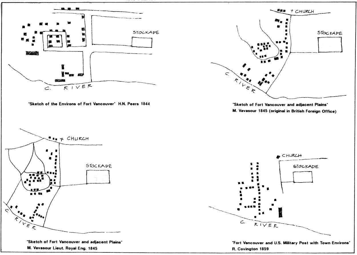
|
| Figure 10. Four versions of the Kanaka Village site from different historic period maps, analyzed and drawn by Terri Taylor, National Park Service, Pacific Northwest Region. (click on image for an enlargement in a new window) |
The information regarding outbuildings and other structures within the village is limited. In later testimony Archibald McKinlay said the village included stables and outbuildings. [673] It is clear from the 1851 George Gibbs sketch that there were small sheds and outbuildings within the village, as well as dwellings. Enclosures as shown on the 1846 Covington stockade area map around some village dwellings, and enclosures consisting of what appear to be post and rail or pole fences can be seen on the Gibbs sketch. Using these two sources as a reference, it appears that those structures which were enclosed were sometimes located near the center of the enclosure, and sometimes at the edge. It is apparent from the Gibbs sketch, which shows livestock grazing freely in the unenclosed areas, that the enclosures were designed to keep livestock out, with one exception. This was a corral, referred to in later testimony, as the Company's corral, the location of which was not specified, but which appears to be an enclosure shown in the 1846 Covington stockade area map, west of the "river road," and south of Upper Mill Road. A Company employee said that the army later used this corral, and it can be seen in an 1851 sketch by George Gibbs. [674] One of Gibbs' sketches of the village area clearly shows a hitching rail near an unidentified crossroads.
An 1860 Boundary Commission photograph looking west towards the quartermaster's house, after most of the village was demolished by the army, shows two buildings, each enclosed within a relatively high stockade, south and slightly east of the quartermaster's house. There is no record of the army having erected structures in that location at that time, and it appears these two enclosed buildings may have been Company structures suffered to stand.
According to later testimony by Archibald McKinlay, some village houses were "...built of logs, boards, squared slabs from the mill, some of them neatly finished and ceiled." Some village houses, noted as finished and "ceiled," were listed in the 1846-47 inventory. [675] William Crate said, "Some of the houses were built Canadian fashion of two or four inch planks; some were built American cottage fashion, framed and weather-boarded; some were of squared timber, and some very few of logs and some few of sawed slabs. The houses were generally one-story high, and some of them 1 1/2; plastered with clay." M.T. Simmons, who saw the village in the mid 1840s, said there were "A good many huts made of slabs rebated in the french style; some had two some had three rooms." [676]
River Front
In this report, the river front complex includes the area bounded by the extension of Lower Mill Road on the north, the "river road" on the east, the forest on the west, and the Columbia to the south. The land in this vicinity generally sloped gently down to the river bank. A pond extended north from a narrow mouth at the river. From various maps, beginning with Covington in 1846, it appears its size and configuration changed somewhat with the rise and fall of the Columbia. It is not shown on the 1844 Peers map, nor on the 1845 Vavasour map, even though Vavasour was careful to point out areas of inundation on the rest of Fort Plain. By 1846, the mouth of the pond was bridged, according to Covington's map.
The best description of the river bank is from William Tolmie, who arrived at the fort in the spring of 1833. It is not clear that he ever, in his several rambles along the river with his friend and colleague, Dr. David Gairdner, was in the vicinity of the river front complex: he never mentions the pond, if he was. But the general description for other areas east and west of this site must have been true for the developed area as well, at least in the early years. On May 5, Tolmie noted that he and Gairdner walked "...along river's bank for a short distance upwards, there is a nice pebbly beach, well suited for bathing & edged with verdant trees & brushwood & elegant wild flowers of various species." On another walk, he noted that "feathered songsters were warbling" in the "grove bordering the river." [677] Tolmie also mentioned walking for an hour "...up and down the ravine from river to fort gate."
By 1846 the river front area was the scene of considerable industrial activity, including tanning, shipping, shipbuilding and repair, warehousing, coopering, and, for a time at least, distilling. In addition, some horses--probably cart and wagon horses, working oxen, and pigs were housed in sheds and stables within the complex. There were also some employee dwellings, for the most part, by 1846 within enclosures, and the Company's hospital. Generally speaking, by 1846, the industrial activities were nearest the river; the stables were located along the west or northwest edge of the pond, and the dwellings along the east edge of the pond. The evolution of the site, at present is known only in general terms.
The earliest mention of a structure possibly located in the complex is by John Warren Dease, who noted that on November 18, 1829, "A house building for the sailors at the water side." [678] If within the complex and still standing in 1846, it could have been one of several buildings shown on the 1846 map, possibly the structure identified as "McLean's," "Smith's", "servants" or perhaps even the hospital.
As has been noted earlier, shipbuilding began early at Fort Vancouver. According to historian John Hussey, the Company's shipyard at Fort Vancouver was used to build barges, "York boats," and other vessels for transport on the Columbia, and there were several attempts to build ocean craft. [679] Dugald Mactavish later said a "good sized schooner [was] built and equipped there, Prince of Wales." [680] A report submitted to the U.S. Senate in 1838 noted that there was a large boat house on the shore. [681] George Emmons noted a boat house near the river bank in 1841, and that same year Eugene Duflot de Mofrás, visiting the fort, said, "On the shore are situated the sheds and dockyards used by barges and small boats. [682]
The small scale of the 1845 Vavasour map makes assessment of the riverside area difficult It appears that there were some small structures at the river side, just above an area labeled "landing; they would have been east of the pond and the salmon store. The 1846 Covington stockade area map shows two sheds near the river bank, one quite large structure, perpendicular to the shore, and one smaller structure, parallel to the shore and just east of the larger building. The 1846-47 building inventory lists a 100 by 24 boat shed and a second 90 by 30 foot building shed; presumably these are the structures shown on the map, although it should be noted that in October of 1846 Thomas Lowe recorded that a boat shed "at the water side" was blown down in a heavy wind storm. Perhaps, as de Mofrás implied, there was more than one boat shed in the area. If the inventory and map were prepared prior to the windstorm referred to by Lowe, then it seems safe to assume that the two sheds on the map were the boat shed and building shed listed in the inventory. If the inventory was compiled after the map, and after the windstorm, then one of the sheds may have been a new building erected in 1846. By 1854, the configuration and relative positions of two long buildings in this vicinity are quite different from that of the two sheds shown on the 1846 Covington stockade area map.
It is assumed that the jetty or wharf, which projected into the water, according to the Covington map, probably dated from the time of the construction of the new stockade, in 1828-29. [683] Dugald MacTavish, at the post off and on, beginning in the late 1830s, later stated that "There were two or three landings on the river as connecting with the fort, at the lower one of which there was a jetty or wharf, with a large warehouse known as the salmon store," [684] Dr. Henry Tuzo, a Company employee at the post in the 1850s, later referred to the wharf as a "landing jetty." [685]
The date of construction of the salmon store or "fish house" is not known; it was listed in the 1846-47 inventory as measuring 100 by 40 feet, and was located west of the pond, at the edge of the river. The building was used to store cured salmon. The Company exported salted or pickled salmon from Fort Vancouver, as well as for home consumption, although, according to Thomas Lowe, the nearest fishery to the post was six miles below the fort, near the mouth of the Willamette. [686] By 1830 some salmon was being salted at Fort Vancouver. [687] The building was later considered by the U.S. Army to have some value, as opposed to most of the Hudson's Bay Company buildings near the river, and, at one point, it was proposed that the structure be moved, rather than demolished, to make way for army structures. [688]
A salt house, which is shown on the 1846 Covington stockade area map just west of the end of the "river road," was used for storing salt imported from Hawaii and England for all the company's pickling and curing--salmon, beef, and pork. In the late '20s and early '30s, obtaining sufficient salt to put up these items was a problem; hundreds of bushels were required to properly store the fish and meat. By 1828 the farm was putting up about six thousand pounds of salted pork, according to a letter from George Simpson to London. [689] The following year, McLoughlin reported he would salt more than forty barrels of pork [690] As noted earlier, cattle were not slaughtered until 1836. The salt house was probably an early building, dating to the late '20s. It was listed on the 1846-47 building inventory as a seventeen by twelve foot structure, and valued at £50.
There are two structures on the 1846 Covington stockade area map, just east of the pond, labeled "tan pits." Apparently used for processing hides, presumably principally of cattle, it seems unlikely they were in use prior to the summer of 1836, when McLoughlin had the first cattle killed for meat at Fort Vancouver. [691] South of the tan pits is a structure labeled "saw pit" It is not known when this was erected; it would have been a useful feature on the farm during any period of its development. Neither the tanning pits nor the saw pit were listed on the 1846-47 building inventory.
A structure which was listed on the 1846-47 inventory, for which there is not accompanying structure on the 1846 Covington stockade area map, is a distillery, 132 feet by 18 feet. However, a later U.S. Army map, dated 1854, does show two long, thin buildings in the complex just east of the pond, whose dimensions seem to approximate the distillery listed in the inventory: one, at least, was probably a boat shed, as discussed previously. From the available evidence, one of several possible conditions applied in 1846. It is possible the distillery was located in one of the sheds shown on the 1846 Covington map, and the boat shed blown down by the windstorm in the fall of 1846 had not been replaced by the time the map was made, but was by the time the inventory was prepared. It is also possible the distillery was located in one of the two structures labeled pig sheds," since the inventory listed only one structure as a piggery. It is also possible the distillery was not located in the riverside complex until after 1846, since all we know of its location is that it was in the complex by the 1850s: if it were moved to the complex after 1846, it may have been located in one of the two long structures shown on the 1854 maps-one of which may have been a boat shed, but both of which seem to post-date 1846. Its location prior to 1846, is then, a question which can not be answered at this time, since structures known to exist by 1846 on Fort Plain have mostly been identified. As noted earlier, McLoughlin had used half of the barley harvest of 1826 in a beer making experiment, and in 1829 missionary Henry Bingham reported he had heard that the Company was soon going to export beer from Fort Vancouver. It was still operating in 1834, according to John Work, but George Roberts said distilling was later given up. [692] Its location was pinpointed by Henry Tuzo, at the fort between 1853 and '58, who later testified that it was located near the boat houses and bridge, and that the U.S. Army quartermaster's men had taken it over.
The Vavasour map of 1845 labels a building in an east-west line of structures near the river as "Hosp." Its position roughly conforms to the position of the hospital as indicated on the 1846 Covington map. On the Covington map, it appears as if an irregularly shaped enclosure extends north from the hospital, and encompasses the edge of a structure labeled cooper's shop. The need for some sort of cooperage near the river seems probable, since the Company had to make hundreds of barrels for shipment of salted pork, beef and salmon, which were stored in the salmon house, and cured with salt stored in the salt house. As noted earlier, a structure just southeast of the stockade was used as a coopers shed or shop by 1846, and possibly earlier, and it is so labeled in the Covington map. It seems possible that the cooper's shop near in the river complex was an earlier building, possibly dating back to the early 1830s, and that many of its functions were moved to the structure near the stockade around 1841: the river front cooper's shop was still being used as such in the summer of 1841, as noted by Lieutenant George Emmons. [693] By 1846 the river front cooper's shop was, according to Joel Palmer, a shed through which the wind and rain blew. [694]
The hospital may have been built during the tenure of Dr. Meredith Gairdner, who arrived at Fort Vancouver with William Tolmie in 1833. [695] Thomas Farnham, at the fort in 1839, noted that the hospital, "in which those of them [the company's servants] who become diseased are humanely treated...," was located in the village, "below the fort, and on the bank of the river." [696] The 1838 report submitted to the U.S. Senate also mentioned a hospital "...on the shore." [697] George Emmons, in July of 1841, said, "...there is a Hospital near the river bank, also stockaded, a cooper's shop, Boat House and several other outbuildings about the premises, besides a small village..." [698] Also in 1841, Eugene Duflot de Mofrás said there was a "...flimsy structure used as a hospital" near the employes houses. [699]
In 1975 and 1977 archaeologists discovered portions of a stockade trench in the vicinity of the hospital and cooper's shed; a northwest and north east corner, and portions of a north wall, west and east wall were discovered, with some posts approximately six to seven inches in diameter. [700] There was some indication that a gate was located forty seven feet from the north east corner, along the east wall, which would have faced the "river road." In so far as can be determined, the northwest corner of this stockade appears to have been close to the northwest corner of the small triangular fenced area shown on the 1846 Covington stockade area map, west of the building labeled "J," and extending in a southerly direction towards the building labeled "Smith's." To the east it extended slightly south of a beyond the corner of the enclosure in which building "J" was located, and then extended south towards the east edge of the enclosure shown on the Covington map, east of the hospital. In an overlay of the archaeological discoveries and a survey done in 1860 by Lewis VanVleet--considered fairly accurate by contemporary archaeologists--it appears that the stockade or fence in this area could have been attached to the north wall of the hospital, and extended well beyond the cooper's shed. There has been some speculation on the reason for a stockaded enclosure, including defence from Indians seeking medical help when supplies were limited. This author believes that there is ample precedence to indicate that relatively low, small picket works or fences of vertically-set poles enclosed several structures in the vicinity of the fort; as has been noted, such fences can be seen in the the 1855 illustrations of the buildings west of the Catholic church north of Upper Mill Road, and in the 1860 boundary photographs looking west towards the quartermaster's house. It appears these fences were used to keep livestock away from buildings and garden areas, and to discourage theft.
The 1845 Vavasour map shows several structures in an approximate line with the hospital. The 1846 Covington stockade area map shows five dwellings, two of which are located near the hospital, labeled "Smith's" and "McClean's." To the north, a building labeled "G" and one labeled "J" are located within an enclosure. The building labeled "G," was occupied some time prior to 1849 by someone named Scarth. The one labeled "J" was occupied by a Robert Johnson. All apparently were Company employees. Another small dwelling is indicated just east of the salmon house, labeled "servant's." To date, no name is identified with that building. The Scarth, Johnson and Smith house were later rented to the U.S. Army. It is not, at present known when they were built: the small scale of the 1844 Peers map makes it difficult to tell if they were extant in that year. There was at least one house in the vicinity by July of 1841, when George Emmons noted "Dr. McL. furnished me a house on the bank of the river for my men to mess in..." [701]
West of the pond was a line of livestock barns, which apparently lined the south or southwest edge of the extension of Lower Mill Road. They can be seen in the 1845 Vavasour map, and are identified in the Covington map as a horse stable, an ox stable and two pig sheds. A stable, 105 by 20 feet, an ox byre, 40 by 25 feet, and one piggery, 40 by 20 feet, are listed in the 1846-47 building inventory, but a second piggery or pig shed is not listed for Fort Plain. This horse stable's presence on the inventory is questionable: a second stable, as noted earlier, was built by the crew of the Modeste on Fort Plain, and, as shown on Covington's map, seems to conform more to the dimensions listed in the inventory than the horse stable shown near the salmon store. Why a second stable is not listed is unclear. The scale of both pig sheds is also questionable, since as shown on the Covington map, they appear to be almost as long as the salmon store, 100 feet Archibald McKinlay, in later testimony, noted that the list did not include "stables and other outbuildings" which he said existed at the fort, and testimony by John Work indicates the stables stood until 1860. [702] Dr. Tuzo, at the fort in 1853, said that to the south of the fort were the "landing jetty, salmon store, long range of stables, and a neat and commodious dwelling..."
It is not known when the livestock buildings were erected. A stable was also in existence at the Mill Plain farm, and one employee noted later that men were sent to Government Island--he referred to it as Goose Grass Island--to gather grass for the working oxen. This seems to indicate that oxen, and possibly working horses broken to harness--necessary for hauling supplies and goods to and from the river--may have been housed in enclosed structures to keep them accessible and in condition for regular work, at least during the winter months. Pigs, oxen and horses were at the post from its establishment on Old Fort Hill. Eugene Duflot de Mofrás, at the post in the fall and winter of 1841, noted that near the village and the hospital were "...a few sheds, two sheep pens, a milkhouse, stables, granaries, and a machine for threshing wheat." [703] The pens, milkhouse, granaries and threshing machine are not shown on the 1846 Covington stockade area map. It is not known if there were such structures near the river in 1841, that were gone by 1846, if de Mofrás was inaccurate in his report, or Covington incomplete. After all, there was a dairy further west on Lower Plain, and sheds for storing grain north of the stockade, as well as the wheat sheds to the east on Fort Plain, near which Douglas' movable threshing machine may have been located while de Mofrás was at the post He is the only witness known to date to place such structures in the river front area.
The Landscape Beyond Fort Plain
The following is a discussion of the features within this historic period of the plains no longer within the park's boundaries.
Lower Plain
Lower Plain was bounded on the east by a stretch of forest and undergrowth extending from the forests of the north to the riverbank, immediately west of Fort Plain and Kanaka Village, about a mile and one-half from the stockade. It ran for about three-quarters of a mile in a narrow band along the river, and then broadened to three or more miles in width, to the southern tip of Big (Vancouver) Lake. A string of narrow lakes formed the northerly border of this narrow band, north of which was an open meadow on which the Company, fairly early on, established a farm called West Plain Farm, generally considered part of Lower Plain. The plain encompassed two smaller lakes beyond Big Lake--Chalifoux and Wapato Lakes--and continued north in a narrow strip to the mouth of the Cathlapootl (Lewis) River. Even Company employees were not certain of the extent of their claim on Lower Plain: in later testimony Dugald Mactavish said at one point that the frontage of Lower Plain ran for ten miles down river, and at another time, said five miles. seems likely that the Company considered any land south and east of the Lake River within its boundaries.
Several visitors gave vivid descriptions of the plain. William Tolmie, who accompanied a riding party on Vancouver Plain--as he called it--in May of 1833 later recorded:
After half an hour's dangerous scrambling through brush & brake & numerous stumps, entered plain, which extends for about 15 miles down river & is generally a mile in breadth. Its surface is diversified with clumps of trees & lakes of water & profusely bedecked with beautiful flowers, amongst which noticed particularly a large species of lupin, a blue orchideous looking plant called Kamas.. .Rich &luxuriant grass afforded an abundant pasturage to 3 or 400 cattle which in different herds were met with as we cantered along. At 1 P.M. reached a lake 3 or 4 miles in circumference bordered by trees in full foliage. On its shores flocks of wild ducks feeding & swallows in thousands skimming its surface. Passed several smaller lochs in returning...All around were herds of beautiful cattle cropping the rich herbage or listlessly lolling under trees--horses, goats & swine seen in every direction attending to the cravings of Nature--on the lochs wild duck abundant & now & then the solitary heron could be seen, standing motionless in shallow water...In traversing pine wood the Governor pointed out to me a tall slender tree having a profusion of large syngenesious flowers called here Devil's Wood...Sugar maple also grows in this wood. [704]
Charles Wilkes, in 1841, said "This was one of the most beautiful rides I have yet taken, through fine prairies, adorned with large oaks, ash and pines. The large herds of cattle feeding and reposing under the trees, gave an air of civilization to the scene...The water was quite high; and many of the little knolls were surrounded by it, which had the appearance of small islets breaking the wide expanse of overflowing water. [705]
Functionally, the Lower Plain had two uses in its early years of development: the West Plain farm, which contained cultivated fields, and the remainder of the plain, which was used to pasture cattle, horses, some sheep and pigs, and, apparently, goats. By 1844, the narrow stretch of the plain just west of the forest separating Lower Plain from Fort Plain had been developed to include cultivated fields, a piggery and a dairy.
On both the Peers map and the 1846 Covington farm map, Upper Mill Road extended through the forest to the east: in 1833, as William Tolmie described earlier, it was still a very rough road, with dense underbrush, and as late as 1845, Vavasour described it on his map as a "Bush Track." En route to Fort Vancouver via the "Callapuya River" Charles Wilkes noted in 1841 how in May, "This branch forms an extensive range of lakes, which reaches to within a mile of Vancouver. The river was now high enough to make it convenient for us to take this route... it becoming necessary to make a short portage within a mile of Vancouver, we concluded to walk thither by the road. In this march we first entered a wood of large pines, which had an undergrowth of various flowering shrubs. The old stumps in the road were overgrown with the red honeysuckle, in full blossom. Lupines and other flowers grow even in the roadway." [706]
By the mid-40s, Upper Mill Road had become a good wagon road, as noted by Archibald McKinlay, In 1844, it skirted to the north of a narrow band of fields, and headed north to the west edge of the West Plain farm, east of the chain of lakes. A road branched off to the south, leading to a dairy located along the river. By 1846, another road skirted the west edge of the lakes, north towards Big Lake, with several additional roads or paths continuing west and north across the plain. By the early 1840s, Alexander Anderson later testified, "A long line of fence was formerly erected immediately above the head of the lower plain, in order to confine the cattle on the lower ranges; there was a gate upon the road, at which a gate keeper was stationed night and day, in order to prevent estrays..." [707] The gate and what must have been the gatekeeper's house can be seen on the 1846 Covington farm map where Upper Mill Road splits into two paths.
West Plain Farm
In 1838 James Douglas inventoried the land at Fort Vancouver, In his report, he noted that the West Plain farm had 76 acres of good land "always available," 52 acres of good land subject to flooding, and 37 acres of "poor shingly land never flooded." [708] This term almost certainly encompassed all cultivated areas west of the stockade on Lower Plain, but it appears that the portion of the farm in Lower Plain first cultivated was the 76 acres of good land, "always available," northeast of the small chain of lakes. By 1841, the fields were planted in wheat, according to George Emmons, and Archibald McKinlay later said the fields were planted in wheat and "other grains" in 1840. [709] The 1844 Peers map shows three fenced fields, and a structure with a small enclosure around it, and the line of fire, which on Lower Plain reached the fields, and consumed the west fence line as it headed south towards the pastures and Company livestock. James Douglas later reported he was able to direct Indians and employees in extinguishing the fire along a two mile line, when it was between the lakes, "preserving the South side of the Plain from its ravages." [710]
The structure shown on the 1844 map is probably the barn to which James Douglas and Thomas Lowe referred when describing the fire in the Lower Plain: it was saved from destruction during the fire. Merchant M.T. Simmons, who was at the fort in 1844, listed the farms at the post, and noted that "the fourth farm was then unenclosed, the fences and buildings having then been recently destroyed by fire. This was a pretty good sized farm." [711] If there were structures damaged by the fire on Lower Plain, it is not evident from the descriptions of the fire, nor from the map. By 1846, according to the 1846 Covington farm map, the contiguity of the fields had been split, with open pasture between two sections of cultivated fields, so perhaps more fences were damaged in 1844 than indicated by the McLoughlin to the directors. There were, according to the Covington map, three barns in the vicinity of the single barn shown on the 1844 map, and Vavasour's 1845 map shows one barn and two sheds in the same general location. However, in the 1846-47 inventory, only one barn, one hundred by twenty feet, is listed for Lower Plain. Dugald Mactavish later testified that new buildings were put up in the mid 1840s "...at the dairies, on Sauvie Island and below Fort Vancouver." [712]
From the 1844 Peers map it appears that the thirty-seven acres of "poor shingly soil" was located in the vicinity of the West Plain farm. As with other areas of the Fort Vancouver Farm, the common practice of improving the soil was to fertilize it by "...folding the cattle upon the impoverished land," as James Douglas reported in 1838, [713] Charles Wilkes noted that the dairy he visited in 1841 was "...removed every year, which is found advantageous to the ground, and affords the cattle better pasturage." [714] Covington's large 1846 map shows a cattle pen and a house between the fields of the West Plain Farm, which are not shown on the 1844 Peers map.
Pastures
It is not known when cattle were first located on Lower Plain--certainly by 1833 when William Tolmie saw them, and probably earlier. In 1829 Laurent Sauve dit Laplante was on the Company rolls as a cowherd, and later as a dairyman or cowherd, but it is not clear whether he tended his charges on Lower Plain or elsewhere, in the early years. Many employees and visitors attested to the presence of cattle on Lower Plain; Dugald Mactavish later said the cattle ranged as far as the mouth of the Cowlitz River.
In describing the plain, Mactavish later said that the "great bulk" of the Company's cattle and horses were pastured on the "alluvial lands of the Columbia River" when it was not under water. [715] When the water was high, the livestock was driven inland to higher ground; some herds were moved to the Back Plains. William Crate and Mactavish later testified that like Fort Plain, the lands along the river had been "throughout seeded with timothy and clover." [716] In 1838 James Douglas told the governor and committee in London that the only "tolerable" pasture on the entire farm was in the marsh lands near the river, and he sent the bulk of the Company's cattle to the Cowlitz, the Tualatin plains, and to Sauvie Island, keeping only enough at the post that could be sustained by the limited pasture in that year of flooding.
James Douglas said that in 1844, horses cattle and sheep were located on the plain, and in early '40s, at least, pigs were allowed to forage on it. George Emmons noted in 1841 that it was on Lower Plain "...that I first learned that pig would voluntarily dive under water, Dr. McL- assuring me that he had frequently witnessed this curious anamoly and watched them until they reached the shore & dispatched their prize which was nothing more or less than a species of clam or oyster." [717] Dugald Mactavish later said "a great number of hogs kept fat there rooting in the soft ground after the waters receded." [718]
Lower Plain was also used for recreational purposes. George Emmons reported in 1841 that near Big Lake, his riding party was "refreshed with some lemonade, one of the Cos. servants having arrived with the necessary ingredients." [719] Thomas Lowe reported Captain Baillie, of the Modeste, hosting a picnic on Lower Plain in 1845.
Indians also camped on the plain: in 1841 Emmons noted "Several large families of Indians encamped under the shade of large oaks on the prairie, the boughs of the latter being their only covering..." [720]
Lower Plain Farm
It is fairly evident that until 1838 what became known as Lower Plain Farm was included in West Plain Farm. This area of land, at the easternmost end of the plain near the river, encompassed about fifty acres, as can be approximately scaled on the 1844 Peers map, and is probably the fifty-two acres which James Douglas reported in 1838 as being "subject to flooding." It is not known when the farm buildings and enclosed fields were developed in this narrow strip of land just west of the woods.
There were at least two dairies on Lower Plain by 1840, according to Archibald McKinlay, and Wilkes also reported two dairies in 1841, where "they milked upwards of one hundred cows." [721] When they were established is not known: Narcissa Whitman reported visiting "the dairy" in 1836, in which she said between fifty and sixty cows were milked, and James Douglas reported in 1838 that the dairy had produced 58 kegs butter "plus needs of depot." [722] In March of that same year Herbert Beaver wrote regarding his alleged treatment at the hands of McLoughlin: "...as with regards to the fresh butter, none of which we have had all the winter, though nearly one hundred cows were in milk last summer." [723]
Narcissa Whitman noted the dairy produced an "abundance" of cheese and butter and that she: "Saw an improvement in the manner of raising cream Their pans are of an oblong square, quite large, but Shallow. Flareing a little, made of wood and lined with tin, in the center is a hole with a long plug. When the cream has all arisen to the surface, place the pan over a tub or pail, remove the plug and the milk will all run off leaving the cream in the pan only. I think these in a large dairy must be very convenient." [724]
Charles Wilkes reported that "They churn in barrel-machines, of which there are several. All the cattle look extremely well, and are rapidly increasing in numbers. The cows give milk at the age of eighteen months. Those of the California breed give a very small quantity of milk; but when crossed with those from the United States and England, do very well. I saw two or three very fine bulls, that had been imported from England." [725]
By 1844 the dairy was located along the river, a mile or so west of the edge of the woods: all three maps of the mid 1840s show two structures at the dairy, although their functions are not identified. Since Wilkes noted that the dairy was managed by a "Canadian and his wife," it is possible one of the buildings was a dwelling. The 1846-47 inventory notes there were three houses on Lower Plain, each twenty by eighteen feet. At least one of them was probably located here, and the second, as noted in the 1846 Covington farm map, in the vicinity of the West Plain farm. The location of the third, was just west of the gate to the Lower Plain, before Upper Mill Road split into two paths to the north, and served, presumably, as the gatekeeper's lodge. The inventory also lists only one dairy, a twenty by eighteen foot structure, which had to have been the second structure noted in the dairy complex; the location of the second dairy is not noted on any of the maps, although as noted above, a "cattle pen" is indicated in the vicinity of the West Plain farm, and there are several unidentified structures on the Covington map near the gate to the Lower Plain. It was apparently this dairy which was destroyed by a falling tree in a strong windstorm in October of 1846. [726]
M.T. Simmons noted that in 1844, the "third farm below the fort" had "good and sufficient farm buildings," with "soil here better than either of the other farms [Mill Plain or Fort Plain]." [727] There were cultivated fields located on either side of the dairy, along the river. By 1846 they were probably at least partially planted in potatoes, since the 1846-47 inventory lists 1,090 yards of fencing "...of potato fields below dairy." On both the 1844 and 1846 maps, a small area of about twenty acres is shown as cultivated and enclosed, west of the dairy.
To the east of the dairy, the 1844 map shows a large cultivated field, beyond which is an enclosed field with a small structure, labeled "piggery." It is shown in the same location on the 1846 Covington farm map, and is listed in the inventory as a structure, sixty by eighteen feet
In February of 1845 what appear to be the first assaults upon Company lands by American squatters commenced. One of the squatters was Henry Williamson, who attempted to lay out a claim from the "men's houses," apparently at Kanaka Village, to the Lower Plain. James Douglas wrote to Simpson that "If he comes to build upon it, we are determined to eject him at all hazards, otherwise they will go on with their encroachments until they take possession of our very garden..." [728] Williamson had, according to McLoughlin, erected "a few logs of wood in the form of a hut" and posted a claim notice. McLoughlin had the logs dismantled and the tree on which the claim notice posted cut down, and later, after a confrontation with Williamson, and an appeal to the provisional government of Oregon, Williamson was evicted. [729]
Mill Plain
Mill Plain was an open "prairie" or meadow of "great extent," approximately three miles long and three-quarters of a mile wide, located north and northeast of the Company's sawmill on the Columbia river. [730] It was bounded on all sides by forest, through which paths, and eventually wagon roads were established.
The "good" roads leading to the Mill Plain, noted by merchant M.T. Simmons in 1844, were probably built between 1841 and 1842. Dugald Mactavish, at the post first as a clerk beginning in 1839, later said "...they opened up roads to Mill Plain and other places, at a great outlay" in 1841 or 1842. [731] He specifically noted: "...a road cut down to the saw mill, one to the gristmill and one of some length cut through rough timber, coming out at the upper end of Fort Plain and placing Fort Vancouver in connection with Mill Plain--all three wagon roads. Also cut through the timber a road from saw mill to gristmill and from gristmill to upper end of fort Plain; this road from saw mill to Fort Plain being close to river front." [732] William Crate, whose first term of service expired in 1843, said he "made the roads from the saw mill to Mill Plain, which is about a mile from the mill, and from that plain to the Fourth plain...these roads were expensive in consequence of the quantity of clearing necessary to open them and keep them in repair." [733]
By 1844 Mill Plain was reached by Upper Mill Road, extending east through the forest east of Fort Plain to the west edge of Mill Plain, where it branched to the north and south. To the north it ran along the north edge of the plain, connecting with a road leading north to the Back Plains and the Camas Plain, To the south, it followed the south border of the plain towards the east, where it eventually completed a loop around the plain. Roads of the south branch led south through the forest to both the gristmill and the sawmill. Access to the plain was also possible via Lower Mill Road, which ran along the river to the mills.
It is evident that Mill Plain was used for some time as pasture for the Company's livestock, prior to the establishment of the Mill Plain Farm, which occurred in the summer of 1841 or early in 1842. The 1838 inventory of cultivable land at Fort Vancouver, prepared by James Douglas, did not mention Mill Plain. In June of 1841 George Emmons recorded that: "About 1/2 mile back from this shore [where the mills were located] is an open high prairie where one of their shepherds resides and looks out for a large flock of sheep a few cattle." [734] Charles Wilkes, in the same month, noted crossing over "to one of the sheep-walks on the high prairie." [735] No mention of a farm was made.
In 1841, Daniel Harvey, recruited as a miller and farmer by the Company for a term of five years, arrived at Fort Vancouver with six merino and six Leicester rams and ewes that were shipped from London. With the position of "clerk," he was placed in charge of the gristmill on the Columbia River, and, from later references, was also placed in charge of the Mill Plain farm. Later referred to in Company rolls as a farmer and a miller, he operated both the gristmill and the farm until his retirement in December of 1849. [736] It appears that the decision to put land on Mill Plain into production was made in order to augment sales and fulfill contracts made by the Puget's Sound Agricultural Company, established in 1839. Artist Paul Kane, at the fort in the winter of 1846-47, noted that Mill Plain farm produced "... more grain than the fort consumes; the surplus being sent to the Sandwich Islands and the Russian dominions." [737] Thomas Lowe's journal entries in the mid-1840s, indicate the farm was used principally to grow grain.
The farm was apparently well-established by 1843; Thomas Lowe recorded the harvest dates of wheat and oats on the plain in July and August of that year, noting that by mid August the grain had all "been cut and carted in." [738] M.T. Simmons noted that in 1844 the farm at Mill Plain was a "large farm with good farm buildings, and under good cultivation; soil is clay and gravel mixed; I consider it good wheat land." [739] By 1844 the Mill Plain Farm had a large rectangular area of cultivated fields on Mill Plain, as can be seen on the Peers 1844 map. The map indicated the area was enclosed by fences, and subdivided into narrow fields. Seven structures--almost certainly wheat sheds--were located in the approximate centers of the fields. A great deal of open space on the plain appears to have been left unenclosed around the edges of the cultivated area, where sheep and cattle were allowed to graze. Dugald Mactavish later said that "Outside the co's fence on this plain was a good deal of open land which was not fenced, for the reason that it was broken up in such a way by the surrounding woods that it was inconvenient to fence it." [740] The map shows two additional structures south of the fields, probably two of the three structures noted in the 1846-47 inventory: a stable, a dwelling, and a warehouse.
The 1846 Covington farm map shows four structures located south of the fields on Mill Plain, and five "barns" within the fields. The map is at odds with the 1846-47 inventory, which lists seven large barns, the stable, the dwelling, the small warehouse, and two shepherd's huts. The barns--whether five, or as is more likely, seven, were used to store grain after harvest, as they were on other parts of the Fort Vancouver farm. In 1844, in describing the fire, Thomas Lowe recorded: "The sheds of grain escaped narrowly, the straw around one having been actually burned to the very base of the Stack." [741] In 1846 he noted in his journal: "Mr. Harvey has got all the Grain taken in, and the Barns are as full as they can hold." [742] The miscellaneous structures are probably among those shown on the Covington map south of the fields, near the north end of the connecting road to the sawmill.
The inventory indicates there was more than nine and one-half miles of fencing on Mill Plain in 1846-47; at least seven fields were enclosed with cross fencing. The total amount of acreage under cultivation listed for the Mill Plain farm was 958 3/4 acres. This total is close to the statements made later by Dugald Mactavish, who said "On the Mill Plain where there was 1,000 acres of land under fence, the cutting and carting of rails required a great deal of labor; the cutting, sawing and carting the lumber from the saw mills back to the plain, with the making of the necessary roads, also required a great many hands." [743] However, the entire area of Mill Plain, including pasturage. could have amounted to almost 2,000 acres.
Both Charles Wilkes and George Emmons referred to sheep on Mill Plain in 1841, and it is probable they were grazed on the meadow for some years prior to that. Livestock were still located on the plain in 1844, when Thomas Lowe recorded that thirty-three head of cattle from "the Snake Country have been received at the Mill plain," and evidence indicates that at least until 1846 sheep, cattle and horses were located on the farm there. [744] William Crate later testified that cattle ranged on the Mill Plain, and Mactavish later noted that, as at Fort Plain, in bad winters cattle were brought to the barns and fed with hay and straw. Mactavish also noted that sheep, cattle and horses were "fed and pastured" on Mill Plain. [745]
The 1846-47 inventory of structures and fields listed 425 yards of fencing for sheep parks, presumably the movable fencing used to help manure the fields, and 680 yards of fencing for the "stable field," which enclosed three and three-quarters acres. The inventory also listed a fifty by twenty foot stable, and two shepherd's huts.
As noted earlier, Wilkes mentioned the sheep pens were movable. Dugald Mactavish later noted that the land on Mill Plain required "the use of sheep for the purpose of manure." [746] While it seems unlikely movable shepherd's huts would have been listed in the inventory, it is possible that the huts were similar to those Chief Factor McLoughlin directed Alexander C. Anderson to erect at Fort Nisqually in April of 1841: "I send the [by the] Cadboro small wooden houses made of inch boards, and mounted on wheels, but all taken to pieces for the convenience of transporting, but are marked so as to be easily put together again. They ought to be put together on arriving, and about 15 August the wood will be thoroughly dry, but if it has shrunk much, the boards ought to be driven close to each other, and the shrinks filled up with putty and then painted one of these houses should be placed in the park where the rams are, and the other in the one for the Ewes and will answer well as houses for the shepherds to lodge in, in Winter and Summer." Later McLoughlin wrote: "You have I presume got the houses for the Shepherds arranged and painted you will apply to Captain McNeil for a little Red paint for the purpose." [747]
Sawmill
In the winter of 1828-29, the Company built its first water-powered sawmill, on a stream about seven miles from fort. The stream had one fall capable of generating about sixty horsepower. It did not suffer from high water during freshets, but back water from the Columbia during flooding sometimes delayed work. [748] At least one dwelling for the millwright must have been erected in the vicinity of the mill soon after, and gradually other houses for workers at the mill, and workshops and sheds must have been added. By 1835, there were at least some employee dwellings located near the mill site. The Rev. Parker gives the best description of the sawmill site in his journal dated October 16, 1835, the day of his party's arrival at Fort Vancouver via the Columbia from the Dalles:
Unexpectedly, about the middle of the day, on the north shore in a thick grove of large firs, I saw two white men with a yoke of oxen drawing logs for sawing. I hailed them, and enquired of them the distance to Fort Vancouver. They replied, 'only seven miles around yonder point, down that prairie.' Soon we came to a very large saw-mill, around which were large piles of lumber and several cottages. This looked like business upon a much greater scale than I had expected. I called a short time at this establishment, where I found several Scotch laborers belonging to the Hudson Bay Company, with their Indian families. Although it was then about noon, they offered me a breakfast of peas and fish, taking it for granted, that men who travel these western regions, eat only when they can get an opportunity. [749]
By 1844, the Peers map shows a cluster of fourteen structures east of the sawmill stream, and three small buildings to the northwest of them. Both George Emmons and Charles Wilkes noted the presence of additional buildings at the sawmill in 1841. Wilkes said: "They have a large smith's shop here, which, besides doing the work of the mill, makes all the axes and hatchets used by the trappers. The iron and steel are imported: the tools are manufactured at a much less price than those imported, and are more to be depended on." [750]
The 1846-47 inventory lists, in addition to two sawmills, the following structures: "One new lumber shed, 45 x 23 1/2 feet; One new ox byre, 34 x 29 feet; One new store, 30 x 18 feet; One new stable, 30 x 18 feet; Men's houses, forge, etc." The 1846 Covington farm map shows nine structures arrayed along the stream and road leading from the mill to Mill Plain farm; there may have been more which he did not bother to show. The list of "new" structures is somewhat puzzling, since there were quite a few more buildings shown on the 1844 Peers map, and the buildings at the mill were not damaged by the 1844 fire. On the Peers map, the structures appear to have some kind of organization, in a rough grid, while in the Covington map, it appears the organizing element, if any, seems to have been the road which ran along the river, crossed the stream, and headed north to Mill Plain farm.
Dugald Mactavish, describing the site in 1846, said the sawmill had a dam, a race and "conveniences for loading ships." Millwright William Crate also noted the presence of staging for loading timber onto ships. In addition, Mactavish said there were houses for the "Co's people," sheds for lumber, stables for oxen and horses, and "...a good deal of land used for gardens in which potatoes and other produce [were] raised." [751] According to William Crate, opposite the sawmill site was a "large island" where the Company procured goose grass for cattle in the winter. He said the men who went to island to get goose grass were employed at nothing else since twenty-four head of oxen were kept at the mill. [752] The island was the present-day Government Island, referred to as Goose Island by some Company employees, apparently because the east end was frequented by wild geese during certain seasons.
In 1832, a millwright, William F. Crate arrived at Fort Vancouver, and, according to his later recollections, says he soon built a new mill, although the closest date he could place on it was before 1843. [753] American entrepreneur Nathaniel Wyeth, not always the most accurate reporter, arrived in Fort Vancouver for the first time in 1832, and reported the presence of two sawmills, although he did not specify their location. [754] However, George T. Allan, a new clerk at Fort Vancouver in 1832, reported a "...threshing mill, flouring mill and sawmill, the last two about six miles above the Fort," giving no indication of having seen more than one sawmill, [755] The missionary Jason Lee, who arrived at the fort in the fall of 1834, toured the farm, and on September 16, noted: "Monday started at seven o'clock, called at a sawmill belonging to the H.B. Co. They are building a new mill and the workmanship does honor to the master,.," From this evidence, it appears that Crate's new mill was built in the fall of 1834. [756]
The new mill was situated downstream from the first. It was, Crate said, "...a gang saw mill with nine saws in the gang and two more saws in a sash, altogether 11 saws," housed in a building about 100 by 40 feet. The overshot wheel, 20 feet in diameter and ten feet wide, was manufactured in England. Crate estimated the cost of the mill as about $80,000; the cranks in the mill, he said, cost £300 each. [757] The mill, according to Reverend Samuel Parker, visiting Fort Vancouver in 1835, was not particularly efficient: "This mill, though large, does not with its several saws furnish more lumber than a common mill would, with one saw, in the United States." [758] Charles Wilkes, head of the U.S. Exploring Expedition, who visited the Fort in spring of 1841, described the mill as being "...placed so low that for the part of the season when they have most water, they are unable to use it. There are in it several runs of saws, and it is remarkably well built. In few buildings, indeed can such materials be seen as are here used," [759]
In the spring of 1838 McLoughlin directed a rebuild of the mill Lieutenant Emmons saw the mill in the summer of 1841, and described the site as follows: "Accompanied Dr. McL-to their mills about six miles up the river on the N bank, both situated directly on the bank on beautiful never failing streams of water which spring from the earth near by, so near that soon after leaving the mills drank from the source of one." [760] Duflot de Mofrás reported: "Two kilometers above the fort, on a small stream that never fails to flow and which empties into the Columbia, a flourmill and a mechanical sawmill equipped to handle a daily output of 3,000 feet of lumber, have been erected, This plant employes a score of workers, all men from the Sandwich Islands, and has horses, oxen and carts in proportion. Not far from these houses, on the opposite side of the river, are the huts of 30 Flathead Indians who sell fish and game to the fort." [761]
William Crate later testified that during his absence, between 1843 and 1849, another sawmill was built alongside the first. It was, he said, a single sawmill about sixty by twenty feet driven by a water wheel in a cistern about twenty by ten feet, built "on the American plan." [762] This must have been the mill referred to by Thomas Lowe in July of 1845, when he noted "...the timber for another Saw mill is...being prepared." [763] The 1846-47 building inventory lists one "substantially built saw mill, 91 x 30 feet, and capable of working a gang of 11 saws, with an overshot wheel of 16 ft diameter," the mill Crate built, and one "new single saw mill, 60 x 19 1/2 ft., cistern 16 ft long, 8 ft square."
Gristmill
As historian John Hussey has noted, it appears a gristmill was located on Mill Creek, about a mile west of the sawmill complex, in 1828-29. [764] Jedediah Smith, at the post that winter, noted "a good saw mill on the bank of the river five miles above, a gristmill worked by hand, but intended to work by water." [765] George T. Allan wrote to a friend in 1832 that a flouring mill and a sawmill were located about six miles above the fort, and that same year Nathaniel Wyeth recorded in his journal the presence of two gristmills at Fort Vancouver. [766] The second mill, as has been noted, would have been the oxen and horse-powered mill north of the stockade.
With plans to increase grain and flour production and the establishment of the Puget's Sound Agricultural Company, it appears the post's managers decided to build a new water-powered mill on Mill Creek. In October of 1838, while McLoughlin was in Europe, James Douglas reported to London that construction of a water powered gristmill, "adapted for two run of 54 inch stones," was underway, with materials prepared for a dam and a mill building. The new mill began operation in May of 1839. [767]
According to William Crate, who was in charge of the mill's construction, Mill Creek, as it is now known, had four falls "within short distance, each power or fall equal to from 21 to 24 horsepower, not troubled by freshets or backwater from the Columbia." It ran in such a way, he said that "you could put one mill every 50 yards or use them all for one mill, all...within 1/2 mile distance." The new mill was located about two or three hundred yards back from the Columbia River. [768] Despite Crate's claims, Charles Wilkes, who saw the mill in the spring of 1841, said it "was not in action," because the river's height at that time "threw a quantity of backwater on the wheel." [769] The mill building, according to William Crate, was 3 1/2 stories high, with two pairs of stones and a wire bolting machine, driven by an overshot wheel. Its construction cost, he said, was £15,000.00. Charles Wilkes called it a "well-built edifice." [770] In the 1846-47 inventory, the buildings was described as "One flour mill, 40 x 20 ft, 3 floors, with 2 pairs stones; a wire machine for dressing flour, with every other convenience." [771] According to George Simpson, the mill could grind 10,000 bushels of grain annually; Thomas Farnham, at the post in 1839 said "...its deep music is heard daily and nightly half the year." [772]
It is not known if there were other structures in the vicinity of the mill prior to 1841, when Charles Wilkes reported a house "annexed" to the mill, belonging to the miller, "who is also the watchmaker of the neighborhood." [773] By 1844, the Peers map showed one large structure, presumably the mill, and two smaller ones just east of it, just south of the Lower Mill Road and east of Mill Creek. In July of 1846 Thomas Lowe noted in his journal that Daniel Harvey, the Company's miller and manager of the Mill Plain Farm, was "...getting a new house built immediately behind his present one at the Mill, and he certainly stands in much need of it." [774] In 1854, an American assessing the claims of the Company, noted the presence of this mill, "now nearly worthless," a newer mill (begun c. 1845-47), and a storehouse and "...miller's house, both built of logs with shingle roofs." [775] The 1846 Covington farm map shows a ford where Lower Mill Road crossed the stream.
The 1846 Covington farm map also shows three structures, in the same vicinity as shown on the Peers map, although the configuration is slightly different, By this time, however, a second mill was probably in the process of construction. In July of 1845 Thomas Lowe noted that James Douglas had selected "the site for a new Gristmill, close along side the old one..." [776] This mill, was evidently intended to replace the first mill; it was "...much larger than the other, 60 x 40 feet, 4 stories high and intended for 8 or 10 run of stones," and William Crate estimated it cost at around $25,000, [777] The mill was noted as "One new flour mill, 60 x 40 ft.," in the 1846-47 inventory. This mill, according to William Crate, was half-finished in 1849, when he returned to the Columbia, and the machinery never completely installed. In 1854 it was noted that the mill had "never been completed." [778]
Back Plains
North and northeast of Fort Plain were the Back Plains, a series of open meadows or prairies in the forests which, during this period, the company used to raise crops and pasture livestock. Thomas Lowe later described their uses: "Lying back of the fort there were several plains separated from each other by belts of timber--those known as the first, second and third plains had each been farmed; the fourth and camass [Camas] plains were used for pasturage." [779]
In 1841 Lieutenant Charles Wilkes explored this area of the Fort Vancouver farm when visiting the post. His is the best general description of the plains:
Throughout these upper prairies, in places, are seen growing pines of gigantic dimensions and towering height, with their branches drooping to the ground, with clumps of oaks, elders, and maple. These prairies have such an air of being artificially kept in order, that they never cease to create surprise, and it is difficult to believe that the hand of taste and refinement has not been at work upon them, [780]
First Plain was the nearest to Fort Plain, about three miles northeast of the stockade. It was an irregularly shaped opening, which according to James Douglas in 1838, contained about one hundred acres of "poor land never flooded." [781] Second Plain, about a mile east of First Plain was smaller; at least according to the 1844 Peers map its area appears to be about two-thirds the size of First Plain, or about seventy acres. Third Plain, about one-half mile east of Second Plain was, according to the Peers map, slightly larger than either of the first two plains. Fourth Plain was, according to historic accounts, about seven miles from the stockade, and was quite large in area, as indicated on the Peers map; its relative size being approximately equivalent to the Mill Plain. East of it was Camas Plain--also referred to as Kalsas, Kolsas, La Kamass and Camass Plain, Another plain is referred to in the historic literature as Simsik Plain, apparently located six miles northeast of Fourth Plain, which may have been used to pasture cattle, and yet another plain, the Prairie du The, apparently located about ten miles east of the sawmill was used to graze cattle, according to William Crate's later testimony. [782]
These plains were connected by a road which extended from Upper Mill Road northeast of the stockade through the forest and plains. To reach the Back Plains it was necessary to ford what is now known as Burntbridge Creek, where, by 1844, a bridge had been built. William Crate later claimed to have built forty miles of "good wagon roads" on the Fort Vancouver farm, although he did not specify dates, Since he was at the post c. 1832-34 through 1843, on his first term of service with the Company, it was within that span of years, probably around the time the Mill Plain farm was established, around 1841-42. Among the roads he said he built, were roads from Mill Plain to Fourth Plain, and from Fourth Plain to Camas Plain and to the Prairie du me. These roads can be seen on the 1844 Peers map. Crate noted he built several small bridges in conjunction with his roads, and that the roads "were expensive in consequence of the quantity of clearing necessary to open them and keep them in repair." [783] Dugald Mactavish later said a wagon road was "made" from Fort Vancouver to Fourth Plain, although he did not specify a date. [784]
As noted above, Thomas Lowe said the first three plains had been cultivated. John McLoughlin noted he had twice planted crops on First Plain by 1837. [785] A second plain was noted by McLoughlin, also with poor soil, but it is not clear to which of the other plains he was referring. In 1832 George T. Allan, then a clerk at the post, noted that "To the north the country is thickly wooded, but now and then relieved by pretty small plains, two of which we have cultivated, though one of them is about six miles distant." [786] If Allan's distances were correct, then by 1832, either Third or Fourth Plain had been at least partially cultivated. James Douglas noted in his inventory of cultivable land in 1838 First Plain, and what he called Second North Plain, six miles from the post, consisting of "120 acres poor land never flooded;" none of the other Back Plains are mentioned in his inventory. If what Douglas called Second North Plain was six miles from the post, and consisted of about 120 acres, it was probably Third Plain, which, according to the Peers map, was only slightly larger than First Plain, which Douglas said had one hundred acres of land. This rather sketchy evidence seems to indicate that it was possibly First and Third Plains which were cultivated by the Company between 1832, when Roberts noted cultivation on two of the plains, and 1838, when Douglas inventoried the land. By 1846, the Covington farm map shows all three plains under cultivation.
The Back Plains were also used to pasture cattle, horses and sheep, although it does not seem they were grazed on these plains year-round. In 1838 James Douglas noted that when the river rose, the cattle were driven to "an extensive arrid plain" ten miles from the river, probably the Prairie du The. [787] Charles Wilkes noted horses and cattle being driven to the plains during his visit to the post. [788] Dugald Mactavish later stated that cattle, horses and sheep ranged from the unfenced areas of the Mill Plain farm "back through belts of timber and openings to the 4th Plain." [789]
The Back Plains were the first of the Company's lands to be successfully occupied by American squatters. In March of 1845 James Douglas wrote that a party of Americans had "taken possession of Prairie du The." [790] By 1849 all the land on the Back Plains were in possession of others, The Company did not claim any land or improvements on the Back Plains in the 1846-47 inventory.
Outlying Areas
As discussed earlier, during this period Fort Vancouver served as the headquarters of the Columbia Department, and as such, was the administrative and supply center for Hudson's Bay Company posts west of the Rocky Mountains. For much of this period, McLoughlin did not appear to take much interest in the interior posts of the New Caledonia district, which was administered by a resident Chief Factor reporting to McLoughlin. He asserted more direct control of those within the Columbia District, which eventually included The Dalles; Nez Perces (Walla Walla), Okanogan, Colvile, Flathead, Kootenai, Nisqually, Victoria, Langley, Rupert, McLoughlin, Simpson and Umpqua. It is beyond the scope of this study to assess the development of these posts, except in so far as they relate to the development of agriculture at Fort Vancouver. For this reason, Fort Nisqually, which was subsumed under the Puget's Sound Agricultural Company, is considered from the preceding list, along with the Cowlitz Farm, established as part of the Puget's Sound Agricultural Company, both of which were--or came to be--a significant part of the Company's agricultural program, and which were closely supervised by McLoughlin, and later, James Douglas.
In addition to these establishments, Fort Vancouver's farming and related operations extended beyond the area north of Columbia River. The Willamette Valley in Oregon Country, by virtue of its settlement by retired Company employees and former fur-trading freemen with ties to the Company in the late 1820s and early '30s, was effectively under the control of Fort Vancouver for many years. It was the site of agricultural operations, centered primarily near Champoeg and on French Prairie, the Tualatin Plains, and Oregon City. Under even more direct control was Multnomah, or Woppatoo Island, now Sauvie Island, which in essence became one of the Fort Vancouver farms in the 1830s.
Willamette Valley
As has been noted, there were temporary camps, fur-trading posts, and possibly some semi-permanent dwellings established in the Valley, principally by fur-trading freemen, by the mid-1820s, and near Champoeg (Campment du Sable), the Company pastured horses needed for fur-trading expeditions. By the early 1830s, several former voyageurs had established homesteads on French Prairie, south and west of the site now known as Champoeg. Of those known to be living and farming in the Valley by 1831--Etienne Lucier, Joseph Gervais, Jean Baptiste Desportes McKay and Louis Labonte--at least one, Lucier, had received assistance from Chief Factor McLoughlin in the form of a loan of cattle, seed wheat, agricultural implements and other items necessary to establish a homestead, By 1832, American Nathaniel Wyeth noted that about twenty-two miles above the Willamette Falls, three or four Canadian settlers had "...Hogs, Horses, Cows, have built barns, Houses and raised wheat, barley, potatoes, turnips, cabages, corn, punkins, mellons." [791] A description of the Gervais farm, built around that time, noted the house was a two-story, eighteen by twenty-four foot structure, and the barn, forty by fifty feet. The McKay, house, by contrast, according to John Ball, in 1833, consisted of a single room. In the ensuing years, additional Canadians and a few Americans settled in the region. [792]
McLoughlin later described his policy in assisting former engages in settling in the Valley:
...I made it a rule that none of the Hudson Bay Company's servants should be allowed to join the settlements unless he had fifty pounds sterling before him, as he required that sum to supply him with clothing and implements. He that begins business on credit is seldom so careful and industrious as he who does business on his own means...When the settlement was formed, though the American trappers had no means, they were assisted on credit, and all in three years paid up from the produce of their farms...I would not sell but loaned as I say, two cows to each settler, and in case the increase of settlers might be greater than we could afford to supply with cattle, I reserved the right to take any cattle I required (above his two cows) from any settler to assist new settlers. [793]
A description of how American John Ball, who came west with Nathaniel Wyeth, established his farm, just east of what is now Champoeg State Park, offers a sense of how such establishments were developed. Ball spent the winter of 1832-33 at Fort Vancouver, teaching in the post's school. In the spring, McLoughlin lent Ball farming implements, unbroken horses, and wheat, corn and potato seed. He lodged with the McKay family while establishing his farm, He fashioned a rough drag and harness for the horses, and used them to haul logs to the site selected for his house. The log house and log rafters covered with cedar bark and anchored with poles. His neighbors assisted in ploughing a large field, around which he built a fence, and in which he sowed wheat. Later he built a small barn. [794]
As historian John Hussey points out, Nathaniel Wyeth's attempt to establish a farm on French Prairie in 1834 harbinged the trickie of American settlers, including missionaries, which in the next decade was to become a flood. Around 1834, the center of settlement began to shift from the vicinity of the McKay farm to the south, where Reverend Jason Lee, in October of 1834, established the Methodist Mission, and to the west and north, across the river, where Ewing Young established his farm, in 1834. In between was Champoeg and McKay's landing. In 1835 a small gristmill was built near Champoeg by Webley Hauxhurst, who arrived in Oregon country with Ewing Young.
By 1835 the Reverend Samuel Parker reported about twenty settlers were living at "McKay's" and at "Jarvis' settlement," mostly Canadians. In 1837 William Slacum, a U.S. Navy purser sent by the state department to report on the Oregon Country reported thirty male residents in the valley, of whom only thirteen were Canadians. Etienne Lucier's farm that year had seventy acres enclosed, four buildings and a gristmill, and was stocked with twenty-one horses and forty-five hogs. Jean B. McKay by that year had sixty-nine enclosed acres with three buildings, thirty-three horses and twenty-two hogs, and Pierre Bellique, also a former Company employee, had fifty enclosed acres, two buildings, nine horses and twenty-eight hogs. [795] Another former engage, Andre Longtain, had a farm of forty-five enclosed acres, two buildings, and three horses and thirty-three hogs. The principal crops grown by these and other settlers appear to have been wheat, oats and potatoes. Generally speaking, only one-half to two-thirds of the enclosed lands were cultivated at the time Slacum visited the Valley. The growing community had a blacksmith in the person of Thomas Jefferson Hubbard, who came to Oregon with Wyeth in 1834, and who, with another former Wyeth associate, James O'Neil, operated a blacksmith shop and farm of two hundred fenced acres. [796]
Although many of the missionaries' own supplies were shipped aboard Wyeth's May Dacre in 1834 from the east coast, they also relied on Fort Vancouver for some supplies. McLoughlin later noted that: "To the methodist Mission, as it was a public institution, I lent seven oxen, one bull and eight cows with their calves." [797] Charles Pickering later wrote that plants and animals introduced by the Hudson's Bay Company were found in "the agricultural settlements on the Willamette and at Cowlitz." [798] All available evidence tends to indicate that in these early years, seed for crops and gardens came from Fort Vancouver.
Wheat was the principal crop, which the Hudson's Bay Company purchased in order to recover its loans to settlers. [799] In 1836 the Company purchased a surplus one thousand bushels from Willamette Valley farmers. [800] By 1839 Willamette Valley wheat was being purchased for shipment to Alaska, to fulfill part of the supply agreement made with the Russian American Company, and to Hawaii; in 1841, McLoughlin noted that he expected about six thousand bushels of wheat from "the Wallamette Settlers," as compared to four thousand bushels produced at Fort Vancouver and between six and seven thousand bushels from the Cowlitz farm. [801] By 1844, as Company clerk Thomas Lowe recorded in his journal, boats were "employed" for around five months "...transporting Wheat from Campment Sable to the Falls [at Oregon City], from whence the Barge generally brought it to this place [Fort Vancouver]..." [802]
To accommodate the settlers, who had to bring their crops to Fort Vancouver via canoe, in 1839 McLoughlin agreed to receive their wheat at Champoeg. and that year dispatched William Tolmie in a Company boat to accept the wheat. Some time between 1841 and 1844 the Company built a warehouse for grain at Champoeg. [803] Champoeg was easily accessible by French Prairie farmers, and was the best spot on the upper river for shipping. In the 1846-47 inventory of structures and land owned by the Company, one granary was listed at "Champooiak," worth £500. It was built on the Company's land on the west edge of what became the Champoeg Townsite, and was later described as having been been "...built with posts set upright, one end set in the ground, grooved on two sides, and filled with poles and split timber, such as would be suitable for fence rails, with plates and poles across the tops...It was twenty by forty feet." [804] By 1846-47, the Company site at Champoeg included a dwelling and outbuildings. A small store for trading goods was established by 1843, possibly in an addition to the granary.
In addition to wheat, the settlers raised peas and potatoes which were sold to the Company. In 1840, McLoughlin reported that both crops in the Valley and at Cowlitz farm had been affected by blight, but that he had "...no doubt we will have a sufficient quantity to fulfil our contract with the Russians." [805] In 1842 he reported the crop of peas was not as good as usual, [806]
As noted above, and in earlier discussion, until 1837, livestock owned by settlers in the Valley consisted principally of horses and hogs. Cattle, "on loan" from Chief Factor McLoughlin, primarily belonged to the Company. McLoughlin had recognized the potential for raising large herds of cattle in the Valley, as is shown by his proposal to establish the Oregon Beef and Tallow Company in 1832, a project which London refused to allow. By 1837, however, settlers in the Valley, principal among them Ewing Young and Jason Lee, wanted to raise cattle under their own auspices, and William Slacum's arrival at that time provided the opportunity, with his offer of free passage to California on his vessel, the Loriot. In January of that year, residents of the valley formed the Willamette Cattle Company, and thirteen of them left for California, returning in October after a long overland drive with between six and seven hundred head of California long-horned cattle. McLoughlin, on his own initiative for the Company, helped finance the drive. According to him:
In 1836 we found means of forming a company to go to California for cattle. I took half the stock for the Hudson Bay Company, so that by purchasing a larger number (as the expense of driving five hundred or a thousand was the same) as it would make the cattle cheaper. Those of the settlers that had means put it in the stock, those that had none, engaged as drivers at one dollar per day, to be paid in cattle at their actual cost. Mr. Slocum, who came here in a chartered vessel, gave them a passage gratis from this place to San Francisco. Mr. Ewing Young was selected to conduct the party. Mr. P.L. Edwards, who came with Mssrs. Lee, of the Methodist Mission, but now a lawyer in California, was appointed Treasurer. They brought, I think, about seven hundred head of cattle, which cost eight dollars per head rendered. In the Willamette, the settlers kept the tame and broken in oxen they had belonging to the Hudson Bay Company, and gave their California wild cattle in the place, so that they found themselves stocked with tame cattle which cost them only eight dollars per head, and the Hudson Bay Company, to favor the settlers, took calves in place of grown up cattle, because the Hudson Bay Company wanted them for beef. These calves would grow up before they were required. [807]
Following the cattle was a flock of between four and five hundred sheep, owned and driven by an American, Jacob Leese, who was living in California. Apparently these were sold to both Fort Vancouver and to settlers in the Valley. [808] The augmented herd of Company cattle were in part located on the Tualatin Plains, which was capable of sustaining large numbers on a year-round basis, unlike the river edge at Fort Vancouver, where flooding at various times of the year required the cattle to be moved inland. Of the herd at Fort Vancouver in 1838, 150 were sent to the Tualatin Plains, which James Douglas considered "superior to any other," Douglas noted in a letter to London that if the cattle did well in the Valley, he would keep them there. [809]
In 1842 Elijah White's party of 140 Americans arrived in the Willamette Valley. By 1845, the population of the Willamette Valley was about three thousand, of which about one-sixth were French-Canadians. As noted earlier, during this period the Company's grip on the Valley's economy slipped considerably, due to the increasing number of Americans and the establishment of individual enterprises. Among the contributing factors were Jacob Gale's arrival from California with a large number of cattle, horses, mules, and possibly sheep, in 1842, of which McLoughlin purchased a considerable number in an attempt to reduce the Company's competition. At the same time, McLoughlin continued his policy of loaning seed and agricultural items to avert, as he put it, famine. [810] At Champoeg, a town site was laid out by American Robert Newell in 1844, and an Oregon City merchant, Francis Pettygrove, built a granary and warehouse there. In 1845, a town three miles east of Champoeg, first called "La Butte," and later, Butteville, was laid out by two Oregon City merchants, who built a warehouse there, and another town, Oxford, was laid out a little to the east of La Butte.
In 1844, the year of the great fire at Fort Vancouver, fires also swept through the Willamette Valley, and, according to McLoughlin and other accounts, greatly damaged the crops and cattle at the "Wallamette Settlement and Jallatine Plains" It appears that after the fire, which occurred as George Simpson was already noting the Company would not retain its hold on the Valley, that the Company began to withdraw its herds from the area, moving them north of the Columbia River. The 1846-47 inventory does not list--as it does at other Company sites, any fencing or land in the Valley, other than lots of land, valued at £300, at Champoeg. The Company still continued to purchase and transport wheat in the Valley, into the late 1840s; in 1846 a flat-bottomed boat was built at Fort Vancouver, designed to transport wheat from the Valley to the post's mill. [811]
Oregon City
Situated on the east side of the Willamette River, just below the forty-two foot drop of the Willamette Falls, Oregon City was, briefly, the principal town in Oregon Country and served as the first seat of the provisional government. Its terrain is composed of three terraces or benches on a steep bluff. The first is a narrow strip along the river, on which the town first developed; it later spread to the second bench, one hundred feet above, now principally a residential district. The third extends east towards the Cascade Mountains, where some pioneer farms were established. It was the falls that drew the Hudson's Bay Company to this particular area of the Willamette Valley, for its industrial potential, that later made it a center of manufacturing activity; its strategic siting--wherein portage around the falls for any river traffic from the Valley interior was necessary; and for the salmon, which were caught by the thousands in season by natives camped at the falls.
As noted earlier, George Simpson directed Chief Factor McLoughlin to build a sawmill at the falls as early as 1828-29, when he and McLoughlin visited the falls. He wrote in his dispatch to London in March of 1829: "...by removing it [the sawmill at Fort Vancouver] at an expense of about £100, twenty miles from hence, to the Falls of the Wilhamot...Saws enough could be employed, to load the British Navy." [812] McLoughlin directed work at the falls in preparation for building a sawmill, and by 1832 a mill race had been completed, and timbers prepared for a mill building. [813] Three log houses were erected near the mill site in 1829-30, and potatoes were planted in the spring of 1830. [814] These structures were burned by natives, and development at the falls languished until 1838, when McLoughlin had squared timbers hauled to the site, and a small building was erected to serve as a house and trading store. [815]
In 1840 McLoughlin gave Jason Lee, the superintendent of the Methodist Mission, permission to erect a mission building at the falls on the Company's land, and Reverend Alvin Wailer, who arrived with the "Great Reinforcement" of missionaries at Fort Vancouver in 1840, was stationed there. A missionary, Felix Hathaway, built a house on what is now called Abernethy Island, in the river near the mainland, which McLoughlin considered to be part of the Company claim. McLoughlin then had a house built on the island. In 1842 the Island Milling Company, comprised mostly of missionary personnel, built a mill on the island, despite Company protests, by McLoughlin. This claim, which later escalated into a territorial dispute, and had a lasting and embittering effect on McLoughlin's later years. Its immediate impact, however, was to force McLoughlin, in an effort to protect the claim, to have the town of Oregon City surveyed and laid out by a recent immigrant to the territory, J.M. Hudspeath, in December of 1842. In 1843 the land was resurveyed by Jesse Applegate, and the surveyed claim filed in McLoughlin's name in December of 1843. At this point, the Company's official interest in the development of the site ceased, and in 1845, when McLoughlin submitted personal drafts to the Company in payment for the claim and property at Willamette Fails--or to present an appearance of payment, as proof of ownership if the Company's claim, as a corporation, should not be upheld--Sir George Simpson accepted the drafts with alacrity and submitted them to London, where they were charged to McLoughlin's account. [816]
In August of 1843 McLoughlin had a gristmill under construction by millwright John Fenton at Oregon City. In June of 1844 clerk Thomas Lowe noted that a party including Chief Factor McDonald and Captain McNeill had left Fort Vancouver in a boat to "... proceed to the Willamette Falls to witness the start of the new Saw Mill the Doctor has had erected there," [817] Both mills were located opposite Abernethy Island on the mainland, although the gristmill apparently did not begin operation until 1846. By 1845 a Catholic clergyman was able to report that: "Oregon City is rising. Since a year ago this post has taken on an astonishing growth. Before that one saw only some huts; today one counts there sixty well-built houses. The Company has a warehouse there; American merchants have established themselves there and have erected a sawmill and a flouring mill. Dr. McLoughlin also has built sawmills there, to which he is going to add other works." [818]
Initially structures fronted the river in the town, but by the mid- 1840s, a street paralleling the river's course--now Main Street--and become the principal route through the town, along which were arrayed the principal residences and businesses; the Methodist church, built in 1844, was located on the southeast corner of what is now 7th and Main Streets.
The mills were located at the south end of the town, near the river, as can be seen in an 1846 sketch by Henry Warre. McLoughlin's own Georgian Revival house, to which he retired in 1846, was located near the corner of 3rd and Main Streets; it was moved to its present site on the second bench in 1909. By 1846 Oregon City had around five hundred residents and seventy structures, including two blacksmith shops, four tailor shops, a hatter shop, two silversmiths, the Catholic and Methodist churches, two taverns, four retails stores, the two sawmills and two flour mills, and a tannery. [819]
Sauvie Island
Sauvie Island--referred to as Multnoma(h) Island or Wappatoo Island during the Company's tenure at Fort Vancouver--is the largest island in the Columbia River. Reverend Samuel Parker described it in October of 1835:
Five miles below the fort, we passed the main branch of the Multnomah [Willamette] river. It is a large river coming from the south, and is divided by islands into four branches, at its confluence with the Columbia. Here commences the Wapatoo island, so called from a nutritive root found in the small lakes in the interior, which is much sought for by Indians as an article of food. This island is about eighteen miles long, and five miles wide, formed by a part of the Multnomah, branching off about six miles up from the main river, running in a westerly and north-westerly direction, and again uniting with the Columbia eighteen miles below the main branch. The branch which flows around and forms the island, is about fifteen rods wide, and of sufficient depth for small shipping most of the year. It was upon this island the Multnomah Indians formerly resided, but they have become as a tribe, extinct. The land is very fertile, and most of it sufficiently high to be free from injury by the June freshet. Some parts of it are prairie, but the greatest part is well wooded with oak, ash, balsam firm, and the species of poplar often called balm of Gilead, and by most travelers, cotton-wood. [820]
American entrepreneur Nathaniel Wyeth described the site where he established his post, Fort William, in 1834-35: "It consists of woodlands and prairie and on it there is considerable deer and those who could spare time to hunt might live well but a mortality has carried off to a man its inhabitants and there is nothing to attest they ever existed except their decaying houses, their graves and their unburied bones of which there are heaps." [821]
As has been seen, Chief Factor McLoughlin decided the Company should occupy Sauvie Island after Nathaniel Wyeth left the west coast in 1836, when his various business ventures failed, apparently to protect Wyeth's interest The extent of improvements at Fort William when the Company occupied it is not known. Later, George Roberts said he "...pulled down Fort William after it was sold and vacated to the HB Co." It was located, Roberts said, "on the Slough side...about four miles from the upper end of the Island it was located with the view to easy communication with the Tualatin plains." [822] To reach the island from Fort Vancouver, stock and overland travelers went about eight miles west of the stockade, to a location about two miles below the Company's salmon station on the Columbia, and were ferried across.
There were some buildings when the Company took over the post--in an April, 1834 letter to a friend, Wyeth mentioned sitting "down in my lodge on the ground." There were probably also livestock formerly belonging to Wyeth. James Lambert, the Captain of Wyeth's vessel, May Dacre, reported he had purchased, as per Wyeth's instruction, at Oahu in March of 1835, "6 fine Milch cows, 1 Jackass, 34 Goats 8 Hogs, 24 Turkies 4 Doz Fowls, 1 Pr English Ducks which are all on board in good order." [823] It is not known, however, if this livestock was intended for Fort William, Wyeth's farm in the Willamette Valley, or Fort Hall, another post he established in southern Idaho. Lambert had also received instruction from Wyeth in Boston in January of 1834 to procure cuttings and roots of the following plants, when in Hawaii: "...Grapes, Sugar Cane, Figs & Sweet Potatoes, put up in wet moss or earth that will keep them, you will be careful to do so, & take with you all the potatoes of our outward stock that you can spare & on your arrival in the Columbia River at your place of Rendezvous you will plant the same in a moist shady place near your establishment..." [824] There is no record of whether Lambert was able to obtain these cuttings, or if he did, if they survived the voyage, or where they were planted if they arrived. In his diary, Wyeth mentioned having planted "Apple trees, seedlings and grafted.." in 1835; turn-of-the century horticulturalist J.R. Cardwell speculated the grafts must have come from the Hawaiian Islands. Wyeth only occupied the place for two years at the most, and, as he frequently noted in his journal, he had a difficult time retaining employees and servants. Fort William was one of three concerns he was attempting to operate during this period, including his farm in the Willamette Valley; it is unknown what happened to the trees, or even if they survived. [825]
The Company had cattle grazing on the island by 1838, when James Douglas noted there was abundant feed on it, but that it was subject to flooding. When McLoughlin returned from London in 1839, with the charge to direct the Puget's Sound Agricultural Company--and its accompanying contract with the Russians to supply butter--he directed the construction of three dairies on the island, all of which were, in 1841, located near the site of Fort William. Archibald McKinlay later said that butter and cheese were made "in great quantities" at three dairies on Sauvie Island and were shipped to Sitka, and Charles Wilkes was told in 1841 that 150 cows provided milk which was churned into butter and cheese for sale to the Russians. [826]
George Simpson, on his visit to the Columbia in 1841-42, noted that the dairy had about two hundred cattle, but that another two or three hundred were allowed to roam the island "...with a view to their breeding..." to increase the Company herds. [827] George Emmons, who visited the "Island of Multnomah" in August of 1841, noted that the Company had a large stock of cattle and horses on the island. [828] The horses may have been located there to provide transportation south to the Willamette Valley; the principal road leading south, past Thomas McKay's, McLoughlin's son-in-law's former farm and oufitting station near what is now Scapoose, began close to the island on the Oregon side. Thomas Lowe later said there were farms on the island, in addition to the dairies, and the inventory of 1846-47 does list two granaries, one of which had a shingled roof. Covington's 1846 map of Fort Vancouver and its vicinity, however, does not show any cultivated land on the island, although it does show three structures in a row, labeled "dairy." An inventory of livestock taken in the spring of 1844 showed 124 horses, 4 mules, 437 head of cattle, 44 oxen and 49 pigs at Sauvie Island. [829]
Four dairies were located on the island in 1844: Gilbot's Dairy, Taylor's Dairy, Sauve's Dairy, and Logie's Dairy. [830] Laurent Sauve dit Laplante had worked as a cowherd for the Company since 1829; his name is applied to the island today. James Logie served as a dairyman between 1837 and 1839, when he was placed in charge of one of the new dairies on the island. Gilbot was Pierre Gilbot, and Taylor, James Taylor. Two other dairymen listed in the Company rolls, according to historian John Hussey, were Malcom Smith, and Murdock McLeod--by 1843, McLeod was at Nisqually. [831] Four dairies were also listed in the 1846-47 inventory of Company improvements at "Sauve's Island," two thirty by twenty foot structures, and two eighteen by eighteen foot structures. In addition, the inventory listed two thirty by twenty foot dwellings, two eighteen by eighteen dwellings, and one fifty by forty foot "ceiled and shingled" dwelling. By the time the list was placed in evidence before the British and American Joint Commission, however, the large dwelling house and the shingle-roofed granary noted earlier, were not on the list. They may have been demolished by that time, or, more likely, had been appropriated by squatters fairly early; James Douglas, in March of 1845, had written to Simpson that settlers had squatted "at Wyeth's place" on Multnomah Island, and, as noted earlier, Covington's map shows only three structures labeled "dairy." [832]
Fort Nisqually
As mentioned previously, Fort Nisqually, situated on the bank of south Puget Sound, was established in 1833 as a fur-trading post, and it operated as such until the establishment of the Puget's Sound Agricultural Company in 1839, when most of its holdings were formally transferred from the Hudson's Bay Company to its new subsidiary. Nisqually came to be the principal location for pasturing the Puget's Sound Agricultural Company's livestock, particularly sheep. A study of Nisqually's development from 1843 to 1859, suggests that the post was moved further north in 1843 because of its new role as an agricultural center. [833]
The first post at Nisqually was sketched by Charles Wilkes and the "so-called fort" described by him in 1841, when he visited the site in his ship, the Vincennes.
The anchorage off Nisqually," he said, "is very contracted in consequence of the rapid shelving of the bank, that soon drops off into deep water. The shore rises abruptly, to height of about two hundred feet, and on the top of the ascent is an extended plain, covered with pine, oak, and ash trees, scattered here and there so as to form a park-like scene. The hill-side is mounted by a well-constructed road, of easy ascent. From the summit of the road the view is beautiful, over the sound and its many islands, with Mount Olympus covered with snow for a background. Fort Nisqually, with its out-buildings and enclosure, stands back about half a mile from the edge of the table land. [834]
The prairies surrounding the site, according to Wilkes, were "covered with flowers of every colour and kind...Ranunculus, Scilla, Lupines, Collinsia..." but the soil, he said was "quite thin," and required "an abundance of rain to bring any crop to perfection, and this rarely falls during the summer months."
The stockade, Wilkes, said, was about two hundred feet square, with four corner bastions, which he illustrated in a sketch plan. In the plan, he showed the structures arranged loosely in a circle, and an open court in the middle. A gate was located in the center of one wall, and opposite it, was a the largest structure within the stockade, probably a dwelling, with structures appended to its back side. Wilkes noted the enclosure included "the agents stores, and about half a dozen houses, built of logs and roofed with bark. This fort was considered quite large when it was first established, but since it has become an agricultural post as well as a trading one, it is found to be too small. Its locality is also ill chosen, on account of the difficulty of obtaining water, which has to be brought from a distance of nearly a mile." [835] At that time Wilkes was shown a garden by Alexander Caufield Anderson, the manager of the post and clerk in the Hudson's Bay Company hierarchy. It was located in an enclosure "just without the pickets" and contained peas, strawberries, gooseberries and "salad gone to seed."
By the time Wilkes visited the post, it was already in operation as a P.S.A.C. farm. He noted grain fields, large barns and sheepfolds, agricultural implements, and workmen "with cattle engaged in the various employments of husbandry." [836] The operation at that time, according to Wilkes, included a dairy with seventy milking cows, from whose milk cheese and butter were made; several hundred head of cattle, and crops of wheat, peas, oats and potatoes. At that time the operations were under the supervision of a farmer and dairyman "brought from England expressly to superintend these affairs." This was probably James Steel, hired as a clerk and farmer in 1839, who arrived at Fort Vancouver from England in October of that year, and who was principally employed at Nisqually; he served out his two-year contract, and returned to England in 1842. [837]
With the establishment of the Puget's Sound Agricultural Company, McLoughlin apparently decided the Fort Nisqually would have to be moved to ground more suitable as a center of agricultural activity, and the years 1840-41 were apparently targeted for the move. In June of 1841 A.C. Anderson, temporarily in charge of Fort Nisqually, told George Simpson "...it is Mr. McLoughlin's intention to have [Nisqually] reconstructed on another site, about a mile distant from its present position..." [838] However, due to a succession of managers at Nisqually with varying management skills and other demands on their time, and a scarcity of labor, construction of the new post near Sequalitchew Creek, where water was readily at hand, was slow: some work in cutting pickets for the new post was done by the crew of the Beaver, in dry dock at Nisqually for repairs in the winter of 1841-42. [839] The new post was located south and east of the creek, where it curved to the north, before heading west to empty into Puget Sound. The principal agricultural buildings were erected across the creek, on the north side.
The development of the Nisqually farm and new post took place for over more than ten years, with much of the development within the stockade proper occurring after 1846; the picket work of the stockade, and its two bastions at the northwest and southeast corners, were not complete until 1848. Prior to that time, the following structures were erected in the area eventually enclosed by the stockade: a twenty by thirty foot officers' dwelling (1843-4), with a separate kitchen to the southeast (1843-4); a ten by fifteen cabin for the clerk (1844), to the north of the officers' house; a block house (1844), eventually enclosed within the stockade; a sixty by thirty storehouse (1844), with a press shed behind (1844) southeast of the officers' house, and partially defining the south edge of what would become the courtyard; quarters for employees, a fifty by twenty foot building (1845-46), northwest of the officers' house, defining the north edge of the court; a second storehouse, thirty by twenty feet (1846), roughly opposite the officers' house, and one of what would become a line of structures defining the west edge of the court. By 1845, there were two other structures situated within what would become the stockade, later replaced by new buildings: a potato house and a dwelling occupied by a Hawaiian, situated west of the store house and south of and in line with the store building along the west edge of the court. [840] These structures were all apparently built in the "Canadian Style." Sketches by Henry Warre and artist Paul Kane in 1845 and 1847 show the buildings to have steeply-pitched gable roofs, unlike the hipped-roofs seen at Fort Vancouver. The setting is also unlike that of the open land around Fort Vancouver; at Nisqually the new stockade was located within or at the edge of a forest: both sketches show large conifers and deciduous trees within the post area. The 1846-47 inventory prepared at George Simpson's behest lists four dwellings, two large stores, and curing store, a large barn, and "outhouses" at Nisqually, but this was noted as an estimate only, since the specific valuation prepared by the then-manager, William Tolmie, had not arrived at Fort Vancouver by the time the inventory was shipped to Simpson.
Like Fort Vancouver, the farm at Fort Nisqually included vast amounts of acreage utilized for grazing, with some locations a considerable distance from the new post In later testimony, the area covered by Fort Nisqually was said to include all the land from the Nisqually River to the Puyallup River, and from the coast to the foothills, a total of 261 square miles. [841] An undated map, which must have been prepared around 1840, shows cattle located at least four miles to the south, north and east of the old fort, and a sheep field at a distance of at least seven miles to the east, It also shows a dairy, just northeast of a "lakelet," later called Sequalitchew Lake, at the northwest edge of what later came to be called Dairy Plain; it seems likely this is the dairy visited by Charles Wilkes in 1841. [842] Like Fort Vancouver, Nisqually had outlying farms, which appear to have actually been sheep and cattle stations. In 1843, a Scotsman, John Montgomery, was listed as the Spaneuh Farm manager, located near Spanoway Lake near the edge of a plain later called Elk Plain. In 1847 John McLeod, a shepherd, was listed as the manager of Whyatchie Farm, presumably located near Wyatchew Lake northeast of the main farm. [843] In 1845, a John Edgar, listed as an outstation shepherd, was listed as the Steilacoom Farm Manager, near the mouth of Steilacoom River. This farm appears to have been the location of "Heath's Farm," listed in the 1846 inventory of lands and structures, which indicated the farm had a dwelling, a barn, stables and outhouses, and one hundred acres of cultivated land.
The heart of the P.S.A.C. operations at Nisqually appear to have been located on the north side of Sequalitchew Creek. By 1845, there were barns, cultivated fields, and sheep folds located along the south and north banks of Sequalitchew Creek, as shown by a sketch map by Mervyn Vavasour, These structures probably dated back to at least 1843, and probably earlier. An 1847 sketch map prepared by William Tolmie, then manager of the post, shows the core of the farm, including the dwellings and stores in the area of the as yet unenclosed stockade, The structures depicted appear to have been devoted principally to cattle operations. To the west was a large structure, with two smaller ones, called a "calf shed," although its size indicates it was probably an enclosure, rather than a building. East of it was what appears to be a round pen, attached to a structure labeled "Slaughter House." East of the slaughter house were a series of long pens, each with a building at the north end, and terminating at the creek to allow stock enclosed in the pens access to water. The buildings were, from west to east, a calf shed, an ox stable, a hay and straw shed, and a horse stable. North of the pens were three barns, which may have been used to store grain; east of the barns were a series of large enclosures which were probably cultivated fields. Just east of the livestock pens and west of the first cultivated field were two dwellings. Along the creek, north of the horse pen, was a dairy, "built across the creek," in which butter, milk and cheese were probably stored. On the south side of the creek, near the livestock pens, were a piggery, with a small enclosure leading to the creek, and a "store used for sheepshearing, beef curing, &c. Further down stream, near the large calf pens, was an enclosure on the south bank, and an area indicated as dammed, where the stream broadened; the latter was identified as a sheepwashing dam.
The southernmost of what appear to be the cultivated fields was noted as "drained swamp and now under potatoes." To its south was an area identified as a meadow on which working cattle were pastured; its south border was the creek. Across the creek was another enclosed pasture for working cattle, East of the future stockade site was what appears to be a rather large garden area, which ran along the creek bank. The 1846-47 inventory noted Fort Nisqually had 220 acres under cultivation, apparently all fenced. The soil at the farm, as noted by Wilkes, was poor, and, as on the poorer soils at Fort Vancouver, cattle were penned on it to manure it. Crops at Nisqually during this period included wheat, oats, barley, peas, potatoes, turnips and colewart. Some areas near the dairy were sown with timothy and clover, as they were at Fort Vancouver, in the early 1840s. [844]
The organization of the farm at Fort Nisqually generally appears to have been tighter, and perhaps more efficient, than that at Fort Vancouver. To a certain extent, the tight operations would have been mandated by the much smaller labor force at Nisqually, and probably to its later development as a farm intended to supply the needs of other posts. In addition, cultivation of crops--with the brief Red River settlement interlude in 1841-43--was never of the highest priority at the post; its intended emphasis was on livestock, as its farm buildings show.
Cowlitz Farm
As previously discussed, the Cowlitz Portage was the termination point of river travel from the Columbia, and the embarkation stage for the overland route to Puget Sound. The farm was established on Cowlitz Prairie, one of many prairies alternating with forests, located between the landing and Fort Nisqually to the north. The prairie was about a mile from the landing. Its size varied, according to who did the estimating: William Tolmie thought it was about four miles long and one mile wide; Duflot de Mofrás thought it was six by two miles, James Douglas said the plain "...contains a surface of about 3000 acres of clear land." [845] The site, Douglas said in 1839, had the disadvantage of "...being separated from the River by a steep, rugged hill impracticable in its present state, to wheeled carriages: and the excavation of a convenient road, will be an enterprise attended with great labour and expense." [846] Lieutenant Charles Wilkes, who arrived overland from the north in 1841 noted the farm was located on "an extensive prairie on the banks of that river [the Cowlitz]." He later reported:
I was told that the stock on this farm do not thrive so well as elsewhere: there are no low prairie grounds on that side of the river in the vicinity, and it is too far for them to resort to the Kamass plains, a fine grazing country a few miles distant, where the wolves would make sad depredations with the increase, if not well watched...The hilly portion of the country, although the soil in many parts is very good, is so heavily timbered as to make it in the present state of the country valueless; this is also the case with many fine portions of level grounds; but there are large tracts of fine prairie suitable for cultivation and ready for the plough. [847]
Eugene Duflot de Mofrás, at Fort Vancouver the same year as Wilkes, described the Cowlitz River route:
Fort Cowlitz is situated on the river of the same name and rises on a plain 6 miles long and 2 miles wide. This river, on whose banks beds of coal and lignite are exposed, rises, as does the Nisqually, on the slopes of Mt. Rainier and empties into the right bank of the Columbia River, a few leagues above its mouth. Its channel, navigable only by barges, is extremely tortuous, being filled with fallen trees, rocks and rapids that make its passage hazardous. At narrow points its banks are steep and great masses of granite formation thickly covered with forests tend to give this country a wild and somber aspect Occasionally, where the country is fairly level, plains covered with rich pasturage are visible. The number of hectares placed under cultivation through the Company's efforts is approximately 100. [848]
By the spring of 1840, some houses had been built, and by the spring of 1841, when Charles Wilkes visited the site, a dairy was in operation, and both a gristmill and sawmill were under construction. [849] In 1845-46 a dwelling, granaries and outbuildings were erected at the mouth of the Cowlitz River to store the farm's produce until Company vessels could pick it up. [850] The inventory of structures in 1846-47 listed a fifty by thirty foot dwelling house; a forty by one hundred foot store and two forty by thirty foot stores, two granaries and the sawmill "& improvements attached, incomplete." In addition, there were a number of outbuildings listed, including thirteen 105 by twenty foot barns, a "close bam," eighty by twenty-five feet, two piggeries, two stables, and six "men's houses."
Two maps of "Cowelitz" Farm as cultivated in 1844-45, and 1845 and Spring 1846 shows the farm's organization to be compact, much more similar in nature to Nisqually's organization than to Fort Vancouver's, obviously due to the acreage available on its large plain. It was organized in a series of abutting rectangular and square fenced fields ranging in size from around nine to 105 acres. Some of the larger fields had the 105 by twenty foot barns, or grain sheds located within them. In the approximate center of the farm was a long rectangular enclosure in which were located two grain sheds and two barns in a line running southeast. Southeast of these were a cluster of buildings, which are not identified on the map, but must have been the dwelling house and possibly the store. Southeast of these, on the banks of a stream, were pigs styes--in 1846 the farm housed around three hundred hogs, excluding the young ones--and a stable, and three houses. Beyond the fenced enclosures, to the east on the plain, were several dwellings. The fields were numbered, and a comparison between the maps shows that crops were rotated within the different fields, although the fields ranging along the southeasterly edge of the farm appear to have been laid down permanently in timothy and clover. An employee later said the Company had "a comfortable, comodious dwelling house; a large two-story granary, with barns and sheds, conveniently distributed at various points over the farm." The lack of a road noted by Douglas in 1839, had been remedied by 1845: "They had a wagon road to the bank of the Cowlitz River, made at considerable cost," The sawmill was located near the Cowlitz River, and sheep--by 1846 about one thousand--were pastured on lands to the north of the farm; horses were pastured on the opposite bank of the Cowlitz. [851]

|
| Map 2. Fort Vancouver Stockade 1829-34/36. Structures within second Fort Vacounver stockade. By Terri Taylor, National Park Service, Northwest Region. |

|
| Map 3. Fort Vancouver Stockade, 1844-46. Structures within second Fort Vancouver stockade. By Terri Taylor, National Park Service, Northwest Region. |

|
| Map 4. 1844 Stockade Area Map by Henry Peers: Sketch of Fort Vancouver and Plain, Representing the Line of Fire in September 1844... The detailed map identifies the crops grown in the fields around the stockade, and contains the only known detailed delineation of Fort Vancouver's garden site. Courtesy Hudson's Bay Company Archives. |

|
| Map 5. Sketch of Fort Vancouver and adjacent Plains (with plan of Fort Vancouver stockade) by Lt. Mervyn Vavasour, 1845. This map shows road systems, including path or road from "Old Fort" site to Columbia River, and details structures in the Kanaka Village and river front complex. |

|
| Map 6. 1844 Peers Map: Sketch of the Environs of Fort Vancouver, embracing a section about 26 miles in length, showing the course of the great Conflagration by which the Fort was nearly destroyed, on the 27th day of September 1844. This map shows the extent of the Fort Vancouver farm in 1844, from the Lower Plain, to the left, to the Mill Plain farm complex, to the right. Del. by Henry Peers. Courtesy Hudson's Bay Company Archives. |
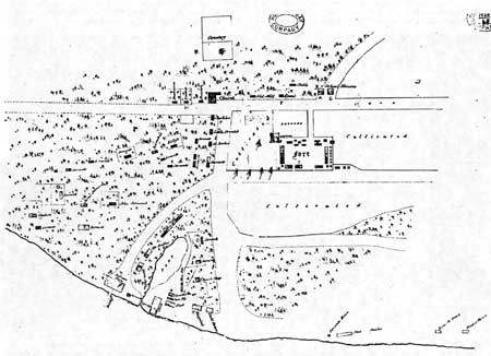
|
| Map 7. 1846 Covington Stockade Area Map: Plan of Fort Vancouver c. 1846, based on portion of map by R. Covington. The letters assigned to different structures on this map keys to a list of structures rented to the U.S. Army by the Hudson's Bay Company in the late 1840s and 1850s. ("Amount of Rent," B.223/z/5, Folios 72-77, HBCA). Courtesy Hudsons' Bay Company Archives. |

|
| (click on image for an enlargement in a new window) |
ENDNOTES
103Among them was a young Captain B.L.E. Bonneville, an officer on leave from the U.S. Army who, with a large trapping company he organized, attempted to trap and trade in the Nez Perces region between 1832 and 1835.
104For further information refer to Merk, Fur Trade and Empire; HBRS IV; E.E. Rich, ed., The Letters of John McLoughlin from Fort Vancouver to the Governor and Committee, Second Series, 1839-1844, Hudson's Bay Record Series Vol. VI, (Toronto: Publications of the Champlain Society, 1943) (Hereafter referred to as HBRS VI); E.E. Rich, ed., The Letters of John McLoughlin from Fort Vancouver to the Governor and Committee, Third Series, 1844-46, Hudson's Bay Record Series Vol. VII, (Toronto: Publications of the Champlain Society, 1944) (Hereafter referred to as HBRS VII); Burt Barker, ed., Letters of Dr. John McLoughlin at Fort Vancouver, 1829-32. (Portland, Oregon: Binfords and Mort, 1948).
106W. Kaye Lamb, "The Founding of Fort Victoria," British Columbia Historical Quarterly, VII (April 1943), p. 81; HBRS VII, pp. 87, 177-191.
107British and American Joint Commission on the Settlement of Claims.
108John Ball, "John Ball's 3rd Letter, Part 1, From Beyond the Rocky Mountains," Zion's Herald, 6 January 1834, Mss. 195, Oregon Historical Society, Portland, Oregon.
109HBRS IV, pp. 259-268; HBRS VII, p. 178; Peter H. Burnett, "Recollections of an Old Pioneer," Quarterly of the Oregon Historical Society V (September 1904), p. 229.
110Large, Journals of William Fraser Tolmie, p. 178.
111Prospectus, 10 March 1832, enclosure in McLoughlin to Governor and Committee, 27 August 1834, D.4/100, HBCA.
112J.H. Pelly to George Cumming, 9 December 1825, Hudson's Bay Company, Miscellaneous, Mss. 1502, Oregon Historical Society, Portland, Oregon.
113John S. Galbraith, "The Early History of the Puget's Sound Agricultural Company, 1838-43," Oregon Historical Quarterly LV (September 1954), pp. 235-237.
115Merk, Fur Trade and Empire, pp. 338-9.
116D.C. Davidson, "Relations of the Hudson's Bay Company with the Russian American Company," British Columbia Historical Quarterly V (January 1941), pp. 45-51.
117Galbraith, Puget's Sound Agricultural Company," pp. 241-2.
118Pelly, Colvile, and Simpson to McLoughlin, 14 September 1839, F.11/1, HBCA.
119Mikell de Lores Wormell Warner, trans., and Harriet Duncan Munnick, ed., Catholic Church Records of the Pacific Northwest, Vancouver, Volumes. land II and Stellamaris Mission (St. Paul, Oregon: French Prairie Press, 1972), introduction, n.p.
120Galbraith, "Puget's Sound Agricultural Company," pp. 247-8. The two priests sent overland arrived at Fort Vancouver in 1839.
122Galbraith, "Puget's Sound Agricultural Company," pp. 252-254; D. Geneva Lent, West of the Mountains: James Sinclair and the Hudson's Bay Company (Seattle: University of Washington Press, 1963), pp. 156-158.
123Governor and Committee to Simpson, 1 March 1841, D.5/6 ins. folio 69, HBCA.
124James R. Gibson, Farming the Frontier: The Agricultural Opening of the Oregon Country, 1786-1846 (Seattle: University of Washington Press, 1985), p. 104.
125Governor and Committee to Simpson, 1 March 1841, D.5/6 ms. folio 69, HBCA.
126Galbraith, "Puget's Sound Agricultural Company," p. 259.
127Hussey, "Fort Vancouver Farm," pp. 90, 111.
128British and American Joint Commission for the Final Settlement of Claims of the Hudson's Bay and Puget's Sound Agricultural Companies, Evidence on the Part of the Puget's Sound Agricultural Company, Vol. III (Montreal: John Lovell, 1868), p. 26 (Hereafter referred to as BAJC, Vol. III).
132James Douglas to Angus McDonald, 24 Jan 1842, James Douglas papers, Correspondence Outward 1830-49, PABC.
134B.223/z/4, folio 211, HBCA; "Papers Relative to the Expedition of Lieut's Warre and Vavasour to the Oregon Territory, Inclosed in Letter from Colonial Office of 3rd November 1846," American, Domestic Various, Vol. 457, p. 86 (typescript), Great Britain Foreign Office Papers Relative to the Expedition of Warre..., PABC.
135McLoughlin to Anderson, April 1841, Fort Vancouver Correspondence Outward to 1846, Part I, PABC.
137McLoughlin to Directors, 20 March 1840, F.12/1, pp. 413-5, HBCA.
138John Work to Edward Ermatinger, 24 October 1839, "Documents," Washington Historical Quarterly II (April 1908), p. 264.
139T.C. Elliott, "British Values in Oregon, 1847," Oregon Historical Quarterly XXXII, (March 1931), p. 36.
141"Copy of a Document," TOPA 1880, p. 54.
142Thomas Lowe, Journal, E.25/1, folios 14-35, Hudson's Bay Company Archives (HBCA).
143Marguerite Eyer Wilbur, ed., Duflot de Mofrás, Travels on the Pacific Coast, Vol. II, Fine Arts Press, (Santa Ana, California: Fine Arts Press, 1937), p. 105.
146BAJC, Vol. II, p. 118; Lewis McArthur, Oregon Geographic Names, 4th ed. (Portland, OR: Oregon Historical Society, 1974), pp. 319-20.
149U.S. Congress, Senate, "J.S. Smith, D.E. Jackson, W.L. Sublette to J.H. Eaton, St. Louis, 29 October 1830." Ex. Doc. No. 39, 21st Congress, 2d sess., pp. 21-23.
150For further information refer to Merk, Fur Trade and Empire; Rich, HBRS IV; Barker, Letters ; HBRS VI ;HBRS VII; Anson S. Blake, "The Hudson's Bay Company in San Francisco," California Historical Society Quarterly XXVIII (September, 1949).
151Simpson to Governor and Committee, 1834, D.4/100 6-6v., HBCA.
152Deals are standard sized plants, 2 1/2 inches thick, 11 inches wide, and 12 feet long.
153Eva Emery Dye, "Documents," Washington Historical Quarterly II, (April 1908), p. 260.
154Erwin F. Lange, "Dr. John McLoughlin and the Botany of the Pacific Northwest," Madrono 14 (1958), pp. 268-272; Ansel F. Hemenway, "Botanists of the Oregon Country," Quarterly of the Oregon Historical Society V (September 1904), pp. 207-214; Harold Fletcher, The Story of the Royal Horticultural Society, 1804-1968 (London: Oxford University Press, 1969), passim; Herman J. Viola and Carolyn Margolis, eds., Magnificent Voyagers: The U.S. Exploring Expedition 1 838.1842 (Washington D.C.: Smithsonian Institution, 1985), passim.
155Dodd, Narcissa Whitman, p. 48.
156A Fort Vancouver historian, Scott Langford, has pointed out that by this time, import duties were charged on the Company's goods, and the Company was prohibited from trading with Indians, citing: Department of the Treasury, U.S. Customs Service, Historical Study #14, The United States Customs Service in Oregon 1848-1849 by Harvey Steele and Hyas Tyee (1990), p. 110; Arthur Throckmorton, Oregon Argonauts: Merchant Adventurers on the Western Frontier (Portland, Oregon: Oregon Historical Society, 1961), pp. 76-77.
157John Kirk Townsend, Narrative of a Journey Across the Rocky Mountains to the Columbia River...and a Visit to the Sandwich Islands, Chili and Etc. with a Scientific Appendix (Philadelphia: Henry Perkins, 1839), pp. 171-2.
158Wilkes, Narrative, IV, p. 350.
159Hussey, Historic Structure Report, Vol. II, pp. 233-244.
160Wilbur, Duflot de Mofrás, pp. 97-98.
161Thomas E. Fessett, ed., Reports and Letters of Herbert Beaver, 1836-38, (Portland,, Oregon: Champoeg Press, 1959), pp. 81-82.
162Wilbur, Duflot de Mofrás, pp. 97-98.
163Parker, Rev. Samuel, A.M, Journal of an Exploring Tour Beyond the Rocky Mountains Under the Direction of the American Board of Commissioners for Foreign Missions. Performed in the Years 1835, '36, and '37.... (Minneapolis Minn: Ross and Haines, 1838; reprint ed., 1967), pp. 159-161.
164John Hussey, Historic Structure Report, Historical Data, Fort Vancouver National Historic Site, Washington, Vol. II (Denver: Denver Service Center, National Park Service, U.S. Department of the Interior), pp. 301-3.
165Hussey, History of Fort Vancouver, p. 173.
166Daniel W. Harmon, A Journal of Voyages and Travels... (reprint ed., New York: Allerton Book Co., 1922), p. 167.
167Merk, Fur Trade and Empire, p. 310.
170James Gibson, "Food for the Fur Traders," Journal of the West VII (January 1968), pp. 26-28.
171British and American Joint Commission for the Final Settlement of the Claims of the Hudson's Bay and Puget's Sound Agricultural Companies, Arguments in Behalf of the United States, with Supplement and Appendix..., Vol. XIII (Washington: McGill & Witherow, 1867), p. 36. (Hereafter referred to as BAJC Vol. XIII).
172Wilkes, Narrative, IV, pp. 359-360.
173Barker, Letters, p. 186; HBRS IV, p. 93.
176This contemplated move, however, was never acted upon. Wilkes, Narrative, IV, p. 334.
178John McLoughlin to Sir George Simpson, 20 March 1844, Oregon Historical Quarterly XVII (September 1916), pp. 224-5.
179The mill's operation is discussed in the section on Mills and Other Industries.
180Unfortunately, Fort Vancouver's journals have been lost.
181[Allan] "Reminiscences," pp.75-76.
182Thomas Vaughan and Priscilla Knuth, eds., "George B. Roberts to Mrs. F.F. Victor, 1878-83," Oregon Historical Quarterly LXIII (March-September 1962), p. 197.
184John McLoughlin to Sir George Simpson, 20 March 1844, Oregon Historical Quarterly XVII (September 1916), pp. 226-7.
185For a further discussion of clerks at Fort Vancouver see Hussey, Historic Structure Report, Vol. II, p. 150-9.
186British and American Joint Commission for the Final Settlement of Claims of the Hudson's Bay and Puget's Sound Agricultural Companies, Evidence for the United States in the Matter of the Claims of the Hudson's Bay and Puget's Sound Agricultural Company...Miscellaneous, Vol. XI (Washington D.C.: McGill and Witherow, 1867), pp. 69,88 (Hereafter referred to as BAJC, Vol. XI).
187British and American Joint Commission for the Final Settlement of Claims of the Hudson's Bay and Puget's Sound Agricultural Companies, Evidence on the part of the Hudson's Bay Company, Vol. II (Montreal: John Lovell, 1868), p. 51 (Hereafter referred to as BAJC, Vol. II).
190HBRS VI, p. 98; Wilkes, Narrative, IV, p. 130.
191Thomas Vaughan and Priscilla Knuth, eds., "George B. Roberts to Mrs. F.F. Victor, 1878-83," p. 183.
192William A. Slacum, "Slacum's Report on Oregon, 1836-7," Quarterly of the Oregon Historical Society XIII (June 1912), p. 186.
193Landerholm, Carl, ed., Notices and Voyages of the Famed Quebec Mission to the Pacific Northwest... (Portland, Oregon: 1956), p. 26.
194John McLoughlin to Sir George Simpson, 20 March 1844, Oregon Historical Quarterly XVII (September 1916), pp. 226-7.
196McLoughIm to Douglas, 21 March 1833, B.223/b/9 ms. folios 4-4d, HBCA.
197Wilkes, Narrative, IV, p. 355.
198Fessett, Herbert Beaver, p. 145.
199Hussey, "Fort Vancouver Farm," p. 188; eventually he and his charges were moved to the island in the Columbia River that today bears his name--Sauvie's Island; see sections of this report under that heading for additional information.
201George B. Roberts, "The Round Hand of George B. Roberts," Oregon Historical Quarterly LXIII (March-September 1962), p. 225. For additional discussion of the Capendales and their stay at Fort Vancouver, see Hussey, "Fort Vancouver Farm," pp. 51-53.
202Alexander C. Anderson, "History of the Northwest Coast," (Victoria, B.C., 1878), Mss. 559, v. 2/4, pp. 4142 (typescript), PABC.
208Large, Journals of William Fraser Tolmie, p. 173.
210Clarence Danhof, Change in Agriculture: The Northern United States, 1820-1870 (Cambridge, Massachusetts: Harvard University Press, 1969), p. 269.
212Danhof, Change in Agriculture, pp. 254-260.
214"Copy of a Document," TOPA 1880, p. 46.
215James Douglas to Angus McDonald, 24 Jan 1842, James Douglas papers, Correspondence Outward 1830-49, PABC.
216Wilkes, Narrative, IV, pp. 356-7.
217George B. Roberts, "The Round Hand of George B. Roberts," passim.
218McLoughlin to Anderson, April 1841, Fort Vancouver Correspondence Outward to 1846, Part I, PABC.
219A. 26/21, folio 47, HBCA. The seeds were procured from the firm of Gordon and Forsythe.
220Merk, Fur Trade and Empire, passim.
222James Douglas to Angus McDonald, 28 December 1841, James Douglas papers, Correspondence Outward 1830-49, PABC.
225George B. Roberts, "The Round Hand of George B. Roberts," pp. 121-2.
226Don Johnson, ed., The Journals of Captain Nathaniel J. Wyeth's Expeditions to the Oregon Country, 1831-36 (Fairfield, WA: Ye Galleon Press), p. 34.
228Roberts Thermometrical Register, Post Journals, B.223/a/7., Fort Vancouver #7, HBCA; HBRS VI, p. 41.
230James Douglas to Angus McDonald, 24 January 1842, James Douglas papers, Douglas Correspondence Outward 1830-49, PABC.
231Thomas J. Farnham, Travels in the Great Western Prairies, The Anahuac and Rocky Mountains and in the Oregon Territory (New York: Greeley & McElrath, 1843; reprint ed. Pacific Northwest National Parks and Forests Association, 1983), p. 98.
232Thomas Vaughan and Priscilla Knuth, eds., "George B. Roberts to Mrs. F.F. Victor, 1878-83," p. 197.
236George B. Roberts, "The Round Hand of George B. Roberts," pp. 121, 147.
237Danhof, Change in Agriculture, p. 207n.
238Landerholm, Notices and Voyages, p. 26.
240Danhof, Change in Agriculture, pp. 228-239.
241Lowe, Journal, folios 9-10.
242Thermometrical Register, B.223/a/7, HBCA.
243Thomas Vaughan and Priscilla Knuth, eds., "George B. Roberts to Mrs. F.F. Victor, 1878-83," p. 197.
244Fessett, Herbert Beaver, p. 79.
245Diary of John Warren Dease, Mss. 602 (typescript), pp. 2-8, PABC.
246Townsend, Narrative of a Journey, pp. 171-2; Danhof, Change in Agriculture, p. 222.
247Farnham, Travels in the Great Western Prairies, p. 98.
248Landerholm, Notices and Voyages, p. 26.
249B.223/d/155 ins. pp. 166-7, HBCA.
251George B. Roberts, "The Round Hand of George B. Roberts," p. 122.
252Diary of John Warren Dease, pp. 2-8.
253Fessett, Herbert Beaver, p. 145.
254Roberts, Thermometrical Register, 1838.
255Slacum, "Slacum's Report on Oregon, 1836-7,"p. 186.
256"Copy of a Document," TOPA 1880, p. 46.
258Elliott, "British Values in Oregon," pp. 27-45.
260U.S. Congress, Senate, "J.S. Smith, D.E. Jackson, W.L. Sublette to J.H. Eaton, St. Louis, 29 October 1830." Ex. Doc. No. 39, 21st Congress, 2d sess., pp. 21-23.
261Merk, Fur Trade and Empire, p. 324.
262Diary of John Warren Dease, pp. 2-8.
263Merk, Fur Trade and Empire, p. 331.
266McLoughlin to McLeod, 1 March 1832, Washington Historical Quarterly II (October 1907), pp. 40-41.
268[Allan] "Reminiscences," pp.75-76.
269John Work to Edward Ermatinger, 5 August 1832, Ms. 319, Oregon Historical Society, Portland, Oregon.
270Johnson, Journals of Captain Nathaniel J. Wyeth's Expeditions, p. 30.
271[Allan] "Reminiscences," p. 75.
273McLoughlin to McLeod, Alexander McLeod, Mss. 2715, PABC.
274Johnson, Journals of Captain Nathaniel J. Wyeth's Expeditions, p. 30. Another visitor to the fort that year, John Ball, said McLoughlin had raised "1,200 bushels of wheat, barley, peas, Indian corn, potatoes and garden vegetables." Ball's figures are so out of line with other reports of the harvest that year, that it seems he was either misinformed or he misunderstood. John Ball, "John Ball's 3rd Letter, Part 1, From Beyond the Rocky Mountains," Zion's Herald, 6 January 1834, Mss. 195, Oregon Historical Society, Portland, Oregon.
275B.223/b/8 ins. folios 13d-17, HBCA.
276John Ball, "John Ball's 3rd Letter, Part 1, From Beyond the Rocky Mountains," Zion's Herald, 6 January 1834, Mss. 195, Oregon Historical Society, Portland, Oregon.
277John Work to Edward Ermatinger, 24 February 1834, Ms. 319, Oregon Historical Society.
278Large, Journals of William Fraser Tolmie, p. 174.
280Large, Journals of William Fraser Tolmie, p. 173.
281John Work to Edward Ermatinger, 24 February 1834, Ms. 319, Oregon Historical Society.
282Townsend, Narrative of a Journey, pp. 171-2. By 1837, however, the fields were definitely being enriched with manure.
284Hussey, "Fort Vancouver Farm," p. 42.
287Dodd, Narcissa Whitman, p 52.
288U.S. Department of the Interior, National Park Service, Whitman Mission Correspondence Vol. 1, June 3, 1834-March 4, 1843, Olaf Hagan, ed. (San Francisco, 1942), p. 86.
289Slacum reported yields of 8000 bushels wheat, 5500 barley, 6000 oats, 9000 peas, 140,000 potatoes and "large quantities of turnips (rutabaga), pumkins and etc." Slacum, "Slacum's Report on Oregon, 1836-7," p. 186.
290Hussey, "Fort Vancouver Farm," p. 53.
291B.223/b/18 ms folios 25-27d, HBCA.
293Fessett, Herbert Beaver, p. 79.
295Landerholm, Notices and Voyages, p. 26.
297Sir George Simpson, An Overland Journey Round the World, During the Years 1841 and 1842 (Philadelphia: 1847), p. 143; Wilkes, Narrative, IV, pp. 356-7.
302John McLoughlin to Sir George Simpson, 20 March 1844, Oregon Historical Quarterly XVII (September 1916), pp. 226-7.
305Douglas and Ogden to Simpson, 19 March 1846, B.223/b/34 folios 15-29d, HBCA.
306Madeleine Major Fregeau, ed., Overland to Oregon in 1845: Impressions of Journey across North America (Ottawa: Provincial Archives of Canada, 1976), p. 76.
307Joel Palmer, "Journal of Travels over the Rocky Mountains, to the Mouth of the Columbia River; Made During the Years 1845 and 1846," in Reuben Gold Thwaites, ed., Early Western Travels, vol. 30 (Cleveland, 1906), p. 210.
308Douglas and Ogden to Governor and Committee, 2 November 1846, B.223/b/34 folios 1-13, HBCA.
311Inventory of Country Produce, Fort Vancouver, B.223/d/22, 1829, p. 11, HBCA.
312U.S. Congress, Senate, "J.S. Smith, D.E. Jackson, W.L. Sublette to J.H. Eaton, St. Louis, 29 October 1830." Ex. Doc. No. 39, 21st Congress, 2d sess., pp. 21-23.
322Wilkes, Narrative, IV, pp. 356-7.
323Ogden and Douglas to Simpson, 15 March 1847, B.223/b/35 folios 66d-67, HBCA.
324James Douglas to Angus McDonald, 27 December 1841, James Douglas papers, Correspondence Outward 1830-49, PABC.
327Merk, Fur Trade and Empire, p. 310.
328George T. Allan to Archibald McLeod, Archibald McLeod Mss., mss. 2715, PABC.
329Barker, Letters pp.277, 289.
330John McLoughlin to Ermatinger, 3 March 1837, Oregon Historical Quarterly XXIII (December 1922), pp. 369-371.
331H.H. Spalding to William and Edward Porter, 2 October 1836, "Documents," Quarterly of the Oregon Historical Society XIII (December 1912), p. 374.
333Merk, Fur Trade and Empire, p. 352; Barker, Letters, p. 161.
334John Ball, "John Ball's 3rd Letter," Zion's Herald.
335Barker, Letters, pp. 292-3. Work's journal of expedition indicates that he was only able to purchase a few horses near San Francisco, see Alice B. Maloney, ed., John Work Fur Brigade to Bonaventura, (San Francisco: California Historical Society, 1945).
336McLoughlin to Archibald McLeod, Archibald McLeod Mss. 2715, PABC; H.H. Spalding to William and Edward Porter, 2 October 1836, "Documents," p. 374.
337"Copy of a Document," TOPA 1880, pp. 51-52.
338Fessett, Herbert Beaver, p. 145.
339Gibson, Farming the Frontier, p. 39. It is unclear from the table in this publication whether the totals listed for Fort Vancouver for each year included cattle pastured on Sauvie Island and in the Willamette Valley; also, after 1839, and the establishment of the Puget's Sound Agricultural Company, cattle were moved between Fort Vancouver, Fort Nisqually and Cowlitz Farm; the number of cattle reported depended to some extent on the time of year.
340HBRS IV, pp. 158-9,184; HBRS VI, p. 228; Rich, HBRS II, p. 699.
341"Copy of a Document," TOPA 1880, p. 51.
344Mathew P. Deady, "Annual Address," Transactions of the ... Oregon Pioneer Association for 1875, p. 27; Townsend, Narrative of a Journey, pp. 171-2.
345Wilkes, Narrative, IV, p. 357.
347Simpson, Overland Journey, p. 106.
348Hussey, "Fort Vancouver Farm," p. 95.
349Wilkes, Narrative, IV, p. 334.
350Dodd, Narcissa Whitman, p. 53; HBRS IV, pp. 158-9; Fessett, Herbert Beaver, p. 145.
351Gibson, Farming the Frontier, Table 16, p. 95.
352HBRS II, pp. 73, 230, 236; HBRS VI, pp. 72-73.
353Dodd, Narcissa Whitman, p. 53.
354Robert C. Clark, ed., Puget Sound Agricultural Company," Washington Historical Quarterly XVIII (1927), pp. 57-59.
355Hussey, "Fort Vancouver Farm," pp. 63-64.
356Indent Books, A.26/21, folio 55, HBCA.
357F.G. Young, ed., "The Correspondence and Journals of Captain Nathaniel Wyeth, 1831-6," Sources of the History of Oregon Vol. I (Eugene, Oregon, 1899), p. 176; John Ball, "John Ball's 3rd Letter," Zion's Herald; Parker, Journal, p. 171.
360Thomas Vaughan and Priscilla Knuth, eds., "George B. Roberts to Mrs. F.F. Victor, 1878-83," p. 199; HBRS IV pp. 248-250.
361Dodd Narcissa Whitman, p.50.
365John Minto, "Sheep Husbandry in Oregon," Quarterly of the Oregon Historical Society III (September 1902), p. 221.
366Wilkes, Narrative, IV, pp. 357-8.
368B.239/1/12, ins. folio 59, HBCA; HBRS VI, pp.390-91.
369Wilkes, Narrative, IV, pp. 357-8.
370Danhof, Change in Agriculture, p. 166.
371HBRS VI, p.228; Galbraith, "Puget's Sound Agricultural Company," p. 259.
372Farnham to Poinsett, Secretary of War, 4 January 1840, U.S. Department of State Documents, #219, PABC.
37527 Cong, 2 Session, House, Rept. of Committee, No 830, 57.
376Douglas to Simpson, D.5/6 ms folio. 198, HBCA.
377Pelly to Palmerston, 30 July 1846, Hudson's Bay Co's Correspondence with Foreign Office Vol. 734, p. 4., Great Britain Foreign Office folder, PABC.
379"Copy of a Document," TOPA 1880, p. 46.
380McLoughlin to Anderson, April 1841, Fort Vancouver Correspondence Outward to 1846, Part I, PABC.
383Eva Emery Dye, "Documents," Washington Historical Quarterly II, (January 1908), p. 164; John Work to Edward Ermatinger, Ms. 319, Oregon Historical Society.
384Parker, Journal, p. 171; Whitman Mission Correspondence, p. 86.
385"Papers Relative to the Expedition of Lieut's Warre and Vavasour to the Oregon Territory," p. 94.
386Danhof, Change in Agriculture, p. 177.
387Indent Book, 1831, A. 26/21, folio 50, HBCA; Barker, Letters, pp. 292-293; Alice B. Maloney, ed., John Work Fur Brigade to the Bonaventura, (San Francisco: California Historical Society, 1945), pp. 38, 41, 42-43, 44.
388John Ball, "John Ball's 3rd Letter," Zion's Herald.
389"Papers Relative to the Expedition of Lieut's Warre and Vavasour to the Oregon Territory," p. 94.
390Wilkes, Narrative, IV, p.359.
391Dodd, Narcissa Whitman, p. 56.
392Large, Journals of William Fraser Tolmie, p. 170.
394Dodd, Narcissa Whitman, p. 50.
395Bradford R. Cole, "The Letter Book of Henry Hall: An Edited Version with an Introduction by Bradford R. Cole," (Master of Science thesis in History, Utah State University, Logan, 1986), p. 203.
397Merk, Fur Trade and Empire, p. 309. A saw mill was eventually established at Willamette Falls--see the section on the Willamette Valley.
398Jason Lee, "Letter to the Corresponding Secretary of the Missionary Society of the Methodist E. Church," 6 February 1835, printed in Christian Advocate and Journal, 30 October 1835, Jason Lee, Mss. 1212, Oregon Historical Society, Portland, Oregon.
399For additional information regarding the mill and its configuration, see the Sawmill section under Site.
401Thomas J. Farnham, an unaccredited citation by George M. Colvocoresses, Four Years in the Government Exploring Expedition Commanded by Captain Charles Wilkes..., 4th ed. (New York: R.T. Young, 1853), p. 261.
Wilkes, Narrative, IV, p. 334.
403Wilbur, Duflot de Mofrás, p. 99.
404Wilkes, Narrative, IV, pp. 358-9.
408Richard Seiber, ed., The Journal of Henry Bridgman Brewer, September 3, 1839 to February 13, 1843... (Fairfield, WA: Ye Galleon Press), passim.
409Lowe, Journal, folios 26-31, 49-53.
410Lowe, Journal, 31 July 1845, n.p.; BAJC, Vol. II, pp 104, 109, 113; BAJC, Vol. XI, pp. 218-228; Elliott, "British Values in Oregon," p. 33.
413Blyndwr Williams, ed. London Corresponence Inward from Sir George Simpson 1841.42 (London: Hudson's Bay Record Society, 1973), pp. 73-74.
414H. Bingham to J. Everts, Feb 16 1829 in George Verne Blue, "Green's Missionary Report on Oregon 1829" Oregon Historical Quarterly XXX (September 1929), pp. 164-5.
415Eva Emery Dye, "Documents," Washington Historical Quarterly II, (January 1908), p. 164; John Work to Edward Ermatinger, 24 February 1834, Ms. 319, Oregon Historical Society.
416George B. Roberts, "The Round Hand of George B. Roberts," p. 197.
417Elliott, "British Values in Oregon," p. 33.; BAJC, Vol. II, pp. 184-6.
418This plain was variously referred to as Camass, Kamas, and Kalsas.
419Parker, Journal, pp. 200-202.
420Merk, Fur Trade and Empire, pp.261-2.
421Parker, Journal, pp. 200-202.
422By the 1880s the bridge over the river was called "Burnt Bridge," possibly derived from its destruction in the fire of 1844, and the river was called "Burnt Bridge River," now Burntbridge Creek.
424John Dunn, The Oregon Territory (Philadelphia: G.B. Zieber and Co., 1845), pp 106-7.
425U.S. Congress, Senate, Report to Senate submitted in Boston, April 21, 1838 to John Davis, Judge, U.S. Dist. Court Massachusetts Dist., by John Sinclair, in S. Rept. 206, 25th Cong., 2d sess., 1838. It has been observed that Dunn was a not particularly reliable witness; Sinclair had political reasons to exaggerate the bounty of the Hudson's Bay Company farm--the report he prepared was part of a move to authorize the president to send troops to Oregon. It must also be noted that Douglas may have been under pressure to put more land under cultivation, in response to the decision the previous year to establish the Puget's Sound Agricultural Company.
426Harvest figures are not available for the years 1837-1839 in identified sources.
428U.S. Congress, Senate, "J.S. Smith, D.E. Jackson, W.L. Sublette to J.H. Eaton, St. Louis, 29 October 1830." Ex. Doc. No. 39, 21st Congress, 2d sess., pp. 21-23.
429OHS Mss 1012, Archibald McDonald, letter to Edward Ermatinger Fort Langley, 5 March 1830, typescript, pp. 2-3.
430Hussey, History of Fort Vancouver, p. 224.
431Archaeologists have divided the expansion into different phases of construction between 1829 and 1860, corresponding to these dates: 1829 to 1834-6; 1834-6 to 1840; 1841 to 1847; 1848 to 1849-54, and 1849. 54 to 1860. J.J. Hoffman and Lester A. Ross, Fort Vancouver Excavations XIII, Structural Inventory, 1829-1860, (National Park Service, U.S. Department of the Interior, May 1976). This report roughly adheres to these phases.
434Marlessa Gray, "Structural Aspects of Fort Vancouver, 1829-1860: An Historical-Archeological Interpretation" (East Lansing: Michigan State University, 1978); Hussey, History of Fort Vancouver; Louis Caywood, Final Report Fort Vancouver Excavations (National Park Service, U.S. Department of the Interior, July 1955); J.J. Hoffman and Lester A. Ross, Fort Vancouver Excavations XIII, Structural Inventory, 1829-1860, (National Park Service, U.S. Department of the Interior, May 1976). Refer to these reports regarding construction techniques, dimensions, and other detailed information.
435Johnson, Journals of Captain Nathaniel J. Wyeth's Expeditions, p. 30.
436Marlessa Gray, "Structural Aspects of Fort Vancouver, 1829-1860: An Historical-Archeological Interpretation" (East Lansing: Michigan State University, 1978).
437Diary of John Warren Dease, pp. 2-8.
438Townsend, Narrative of a Journey, pp. 171-2.
439Large, Journals of William Fraser Tolmie, p. 170.
440Hussey, Historic Structure Report, Vol. II, pp. 416-422.
441What may have been a fifth well was located outside the stockade, along the north wall in the garden, using remote sensor survey in August of 1991. James W. Bell, Report of the Remote Sensing Survey at Fort Vancouver National Historic Site (Seattle: Pacific Northwest Regional Office, National Park Service, 1991).
442John A. Hussey, Historic Structure Report, Historical Data, Fort Vancouver National Historic Site, Vol. I (Denver: Denver Service Center: National Park Service, U.S. Department of the Interior, 1972), pp. 61-70.
443He was to die at the Dalles in January of 1830.
444Diary of John Warren Dease, Mss. 602, pp. 2-8 (typescript), PABC.
445[Allan] "Reminiscences," p. 75.
446Large, Journals of William Fraser Tolmie, p. 172-3.
447Diary of John Warren Dease, pp.2-8. Most Company employees referred to the residence of the chief factor as the "Big House." See also Hussey, Historic Structure Report, Vol. I, pp.89-90.
448Jason Lee, "Jason Lee's Diary," Oregon Historical Quarterly XVII, (September 1916), p. 262.
449Cyrus Shepherd Diary, 1834-35, Mss. 1219, p. 65, Oregon Historical Society, Portland, Oregon.
450W.H. Gray, A History of Oregon 1798-1849..., (Portland, Oregon: 1870), p. 150.
451Marlessa Gray, Structural Aspects of Fort Vancouver, 1829-1860, pp. 184-197.
453U.S. Congress, Senate, Report to Senate submitted in Boston, April 21, 1838 to John Davis, Judge, U.S. Dist. Court Massachusetts Dist., by John Sinclair, in S. Rept. 206, 25th Cong., 2d sess., 1838.
454Captain Edward Belcher, 1907, The Beaver (September 1954), p. 30.
455Landerholm, Notices and Voyages, p. 26.
456Colvocoresses, Four Years in the Government Exploring Expedition, p. 260.
458Captain Edward Belcher, 1907, The Beaver (September 1954), p. 30.
459Colvocoresses, Four Years in the Government Exploring Expedition, p. 260.
460U.S. Congress, Senate, Report to Senate submitted in Boston, April 21, 1838 to John Davis, Judge, U.S. Dist. Court Massachusetts Dist., by John Sinclair, in S. Rept. 206, 25th Cong., 2d sess., 1838.
461Fessett, Herbert Beaver, p. 145; Landerhohn, Notices and Voyages, p. 26.
462Colvocoresses, Four Years in the Government Exploring Expedition, p. 261.
463Fessett, Herbert Beaver, pp. 81-82.
464Also referred to in the literature as the Indian Trade Store.
466Captain Edward Belcher, 1907, The Beaver (September 1954), p. 30.
467Landerhohn, Notices and Voyages, p. 26.
468Wilkes, Narrative, IV, p. 349.
469Hoffman and Ross, Fort Vancouver Excavations XIII, Structural Inventory, passim.
470Fessett, Herbert Beaver, pp. 81-82. A watercolor of the stockade interior c. 1846-47 by Lieutenant Coode showed the central open space colored green, possibly indicating grass, however, the illustration was executed eight years after Beaver's comments (See the section, "The Stockade: 1841-46," for additional discussion of the interior at the time of Coode's watercolor).
472Wilkes, Narrative, IV, p. 354.
475Joel Palmer, Journals of Travels over the Rocky Mountains to the Mouth of the Columbia River Made During the Years 1845 and 1846, (Eugene, Oregon: University of Oregon, 1852), p. 112.
476Hussey, Historic Structure Report, Vol. I, pp. 47-60.
477Wilbur, Duflot de Mofrás, pp. 97-98.
478"Papers Relative to the Expedition of Lieut's Warre and Vavasour to the Oregon Territory," pp. 53-55.
479See discussion of the bakehouse in Hussey, Historic Structure Report, Vol. II, pp. 47-51.
482Lowe, Journal, folios 14, 27-31.
484Wilbur, Duflot de Mofrás, pp. 97-98.
485"Papers Relative to the Expedition of Lieut's Warre and Vavasour to the Oregon Territory," pp. 16-17.
487For a discussion of the pattern, see the next section.
488Archaeologists J.J. Hoffman and Lester Ross bracket its construction between 1829 and 1860; Hoffman and Ross, Fort Vancouver Excavations XIII, Structural Inventory, p. 67.
489Gray, Hoffman and Ross (1976).
490Lowe, Journal, February 1845, n.p.
491Lowe, Journal, 31 December 1844, n.p.
493Bryn Thomas and Jerry Galm, "Archaelogical Testing and Data Recovery Excavations for a Proposed Utility Corridor Fort Vancouver National Historic Site," Eastern Washington University Reports in Archaeology and History 100-57 (Cheney: Archelogical and Historical Services, Eastern Washington University, 1987), pp. 161-2.
495Thomas and Galm, "Archaelogical Testing and Data Recovery Excavations for a Proposed Utility Corridor," passim. Telephone interview with Thomas, September 1991.
496British and American Joint Commission for the Final Settlement of the Claims of the Hudson's Bay and Puget's Sound Agricultural Companies, Evidence for the United States in the Matter of the Claim of the Hudson's Bay Company.... Vol. IX (Washington, D.C.: McGill & Witherow, 1867), pp. 75-77 (Hereafter referred to as BAJC, Vol. IX).
498Elliott, "British Values in Oregon," p. 35.
499Large, Journals of William Fraser Tolmie, p. 173.
501Neither the 1846 Covington map nor the 1844 Line of Fire (Peers) map show this road.
502Large, Journals of William Fraser Tolmie, p. 174.
504Lowe, Journal, folios 17-20.
507"Extracts from British Foreign Office Documents," PABC.
508Large, Journals of William Fraser Tolmie, p. 173.
509Warner and Munnick, Vancouver, I, p. 23. Priests arrived at Fort Vancouver in November of 1838--Fathers Francois Norbert Blanchet and Modeste Demers.
511Diary of John Warren Dease, pp. 2-8.
512B.223/b/9, folios 4-4d, HBCA.
513There is one cryptic reference to "the small granary" being located within the stockade near "the north pickets" by Thomas Lowe in December of 1844, but the reference at this point is believed to have been to the granary built in 1838-39, even though it was not a particularly small building. See Hussey, Historic Structure Report, Vol. I, pp 72-73.
515Fessett, Herbert Beaver, p. 79.
516U.S. Congress, Senate, Report to Senate submitted in Boston, April 21, 1838 to John Davis, Judge, U.S. Dist. Court Massachusetts Dist., by John Sinclair, in S. Rept. 206, 25th Cong., 2d sess., 1838.
517Farnham, Travels in the Great Western Prairies, p. 98.
518Landerhohn, Notices and Voyages, p. 239.
520Farnham, Travels in the Great Western Prairies, p. 98.
521Landerholm, Notices and Voyages, p. 26.
522Eva Emery Dye, "Documents," Washington Historical Quarterly II, (January 1908), p. 164; John Work to Edward Ermatinger, 24 February 1834, Ms. 319, Oregon Historical Society.
523Slacum, "Slacum's Report on Oregon, 1836-7,"pp. 175-224.
524Landerholm, Notices and Voyages, p. 239.
526Lowe, Journal, folios 17-20.
528Landerhohn, Notices and Voyages, p. 239.
531Born in Ireland, Ryan is first seen in the Vancouver Catholic church records in June of 1848; he married a widow, Suzanne Harless Coquerel; their first child was born in 1849. Warner and Munnick, Vancouver, II, pp.95, 97, 99, 102, 113. The 1850 census lists him as a fanner. Ryan was close enough to some Company employees--Barclay, Petrain, and others--to serve in various capacities at church ceremonies in relation to them, as godfather, witness, and so forth.
532Lowe, Journal, 1 July 1846, n.p.
533Charles Carey, ed., The Journal of Theodore Talbot 1843 and 1849-52, With the Fremont Expedition of 1843 and with the First Military Company in Oregon Territory 1849-1852 (Portland, Oregon: Metropolitan Press, 1931), p. 88.
534Hussey, History of Fort Vancouver, pp. 207-8.
535Brief biographies are given of Duchenee (Ducheney), Proulx and Lattie in Warner and Munnick, Vancouver.
536Warner and Munnick, Vancouver, passim.
537Ibid., pp.179-80; 208-213; Bryn Thomas, "An Archaeologic Assessment of the St. James Mission Property, Vancouver Washington," Eastern Washington University Reports in Archeology and History 100-37 (Cheney: Eastern Washington University, 1984), passim.
538For a complete discussion of the Catholic mission, see Thomas, "An Archaeologic Assessment of the St. James Mission Property, Vancouver Washington."
540Thomas, "St. James Mission," p. 12.
541Hussey, "Fort Vancouver Farm," p. 28.
542Frances Fuller Victor, "Flotsam and Jetsom of the Pacific," Quarterly of the Oregon Historical Society II (March, 1901), pp. 38-39.
543Hussey, The History of Fort Vancouver, p. 126. Information regarding the stockade wall alterations is derived principally from Hoffman and Ross, Fort Vancouver Excavations XIII, pp. 3-11; Marlessa Gray, Structural Aspects of Fort Vancouver, 1829-1860, pp. 184-197.
544Whitman Mission Correspondence, p. 86.
545James W. Bell, "Report of the Remote Sensing Survey at Fort Vancouver National Historic Site," (1991), passim.
546Dodd, Narcissa Whitman, p. 50.
547Whitman Mission Correspondence, p. 86.
548By 1845, however, it was the firm of Evans and Lascelles which was providing the Company with seeds for the North American posts.
549Indent Books A. 26/21, 1831, folio 47, HBCA. Unfortunately, the indent books for the Columbia Department beyond 1831 are not available.
550Charles Pickering, The Races of Man and Their Geographic Distribution, pp. 319-321.
551Wilkes, Narrative, V, p. 143.
552Dodd, Narcissa Whitman, p. 57.
553O.B. Sperlin, ed., "Our First Horticulturist--Brackenridge's Journal of the Chehalis Route, 1841" Washington Historical Quarterly LXXII (April 1931), pp. 140-141.
554Smith to Edmonds, 26 October 1838, London, A.5/12, p. 212, HBCA.
555George B. Roberts, "The Round Hand of George B. Roberts," p. 199.
556Portledge Books, 1833-1843, C/3/14, HBCA.
557Hussey, "Fort Vancouver Farm," p. 37.
558Roberts, Thermometrical Register, 1838.
559Tolmie to Smith, 27 July 1842, in Summary Files, Msc. Notes, Vancouver, A.10/15, HBCA.
560Wilbur, Duflot de Mofrás, p. 98.
561[Allan] "Reminiscences," p. 76.
562Johnson, Journals of Captain Nathaniel J. Wyeth's Expeditions, p. 30.
563John Ball, "John Ball's 3rd Letter," Zion's Herald.
564Large, Journals of William Fraser Tolmie, p. 170.
566Jason Lee, "Letter to the Corresponding Secretary of the Missionary Society,"Jason Lee, Mss. 1212, Oregon Historical Society.
567Townsend, Narrative of a Journey, pp. 171-2.
568ABC Papers, Cherokee Mission, ms vol. 9, item 203.
569Dodd, Narcissa Whitman, p. 50.
570Wilkes, Narrative, IV, p. 354.
571Large, Journals of William Fraser Tolmie, p. 334.
572Johnson, Journals of Captain Nathaniel J. Wyeth's Expeditions, p. 34.
573John Ball's letter to Amons Eaton 24 Feb 1833, OHS mss 195.
574Large, Journals of William Fraser Tolmie, p. 170.
577Townsend, Narrative of a Journey, pp. 171-2.
578Cyrus Shepherd, "Diary," 1834-35, pp. 65-66.
581Dodd, Narcissa Whitman, p. 50.
582Cyrus and Susan Shepherd, Letters, p. 1, Mss. 1219, Oregon Historical Society, Portland, Oregon.
583W.F. Tolmie to Aunt, 22 September, 1838, Tolmie Add. Mss. 557, V. 1, folder 6, PABC.
584Thermometrical Register by George Roberts, 1838. HBCA Post Journals, B 223/a/7. Fort Vancouver. #7.
585Sperlin, ed., "Our First Horticulturist--Brackenridge's Journal," pp. 140-141.
587Pickering, The Races of Man, pp. 319-321.
588Lowe, Journal, folios 11-14.
590Lowe, Journal, folios 17-20.
593Jesse Applegate to Mrs. Frances F. Victor, 19 October 1868, Letters of Jesse Applegate, Elwood Evans Scrapbook (transcript), Oregon Historical Society, Portland.
594Dunn, The Oregon Territory, pp. 143-47.
595Large, Journals of William Fraser Tolmie, p. 170.
596Hussey, "Fort Vancouver Farm," pp. 36-37, n. 135.
597Sperlin, ed., "Our First Horticulturist--Brackenridge's Journal," pp. 140-141.; Wilkes, Narrative, IV, p. 354.
598Wilkes, Narrative, IV, p. 354.
599Portledge Books, 1833-1843, C/3/14, HBCA.
600Thomas Vaughan and Priscilla Knuth, eds., "George B. Roberts to Mrs. F.F. Victor, 1878-83," p. 199.
601Fessett, Herbert Beaver, p. 145; Wilkes, Narrative, IV, p. 332.
602Correspondence Book, Fort Vancouver 1836-37, B.223/b/16 fols 17d., 19d, HBCA.
603Fessett, Herbert Beaver, p. 173.
604Dodd, Narcissa Whitman, p. 50.
605Mrs. H.H. Spalding, to O and C Porter, 2 October 1836, Oregon Historical Quarterly XII (December 1912), pp. 378-79.
606Cyrus Shepherd, 'Diary,' 1834-35, p. 66.
607H.H. Spalding to William and Edward Porter, "Documents," p. 378.
608John Minto, "Beginning Life in Oregon," subtitled "My Beginnings in Horticulture," p. 11, Minto Mss., Files 2-6, Oregon Historical Society, Portland, Oregon. The mission was abandoned in 1843, and Minto had a partnership claim on its land for a short time. It should be noted that Lee had arranged with Nathanial Wyeth to ship garden seeds and other materials via Wyeth's brig, the May Dacre, when Wyeth left Boston on his second expedition. Also, Jason Lee and his nephew, Daniel Lee, placed the site of the Methodist Mission near the farm of a French Canadian settler, Joseph Gervais, who at that time, was already growing melons and cucumbers, the source for which was almost certainly Fort Vancouver. The Hudson's Bay Company exercised great influence on the early settlers in the Willamette Valley, many of whom were former engages, although Gervais himself had worked for the Astor company.
609W.F. Tolmie to Aunt, 22 September 1838, Tolmie Add Mss. 557, V. 1, folder 6, PABC.
610National Park Service landscape architect Terri Thomas has determined, using the historic map and archaelogically-located features, that the actual area within the enclosure which was planted with trees was about 380-400 feet by 600 feet.
611No one at that time knowing the Bruce would soon be back at the fort.
612Thermometrical Register by George Roberts, 1838. HBCA Post Journals, B223/a/7. Fort Vancouver.
613Farnham, Travels in the Great Western Prairies, p. 98.
614Sperlin, ed., "Our First Horticulturist--Brackenridge's Journal," pp. 140-141.
615Charles Pickering, The Races of Man, pp. 319-321.
618Hussey, "Fort Vancouver Farm," pp. 60-61. For example, Dunn's description of the farm is very similar to T.J. Farnham's description in his book, published in 1843.
619Crabapples native to the Pacific Northwest can be used as rootstock.
620F.G. Young, ed., "The Correspondence and Journals of Captain Nathaniel Wyeth, 1831-6," Sources of the History of Oregon Vol. I (Eugene, Oregon, 1899), p. 255.
621John Minto, "Learning to Live on the Land," p. 4, Minto Mss., Boxes 2-6, Oregon Historical Society, Portland, Oregon.
622Granville Lowther, ed., The Encyclopedia of Practical Horticulture: A Reference System of Commercial Horticulture (North Yakima, WA: Encyclopedia of Horticulture Corporation, 1914), p. 63; William Barlow, Reminiscences of Seventy Years," Oregon Historical Quarterly 13, pp. 277-8.
623There is another type of nineteenth century fencing composed of split rails, fastened to posts with iron hooks or pins, which would avoid the at least five foot bed width required by a zigzag, since all rails would be in line with the posts; constructing such a fence would be much more labor intensive than the zigzag. A third type of fence would be a pole fence, where pre-bored poles are set in a straight line; pins are driven diagonally into the posts, and the poles are laid in place. This type of fence usually had diagonal bracing at every post. Pole fences were also sometimes connected using withes of saplings or slender limbs, twisted to make a loop which fits over the butt ends of diagonally placed poles.
624Landerholm, Notices and Voyages, p. 239; Lowe, Journal, folios 17-20.
625Cyrus Shepherd, "Diary," p. 66.
626Cyrus and Susan Shepherd, Letters, p. 1.
627Paul Kane, Wanderings of an Artist among the Indians of North America From Canada to Vancouver's Island and Oregon Through the Hudson's Bay Company's Territory and Back Again, (London: Longman, Brown, Green, Longmans, and Roberts, 1859), p. 186.
628BAJC, Vol. II, pp. 111, 180.
631It is interesting to note that the 457 cultivated acres Douglas reported for Fort Plain in 1838 is the exact same total reported for the combination of cultivated fields of Fort Plain and Dairy Plain--the portion of Lower Plain near the dairy--prepared for the 1846-47 inventory. See Elliott, "British Values in Oregon, 1847," p.33.
633Townsend, Narrative of a Journey, pp. 171-2.
634HBRS IV, p. 205. Captain Edward Belcher reported in 1839, "The average produce of the soil per acre is as follows: 15 bushels pease, 20 bushels wheat, 30 bushels oats, 35 bushels barley..." There is some question whether Belcher was referring to the "Wallamette settlement" or to Fort Vancouver. Captain Edward Belcher, 1907, The Beaver (September 1954), p. 30.
635[Allan] "Reminiscences," p. 75.
636Large, Journals of William Fraser Tolmie, p. 171.
638Acreage was calculated using two different methods: 1) Using a scale based on the known dimensions of the stockade in 1844, based on archaeological evidence, then applied to the 1844 stockade area map; 2) Using the scale shown on the 1844 stockade area map. The range for various field sizes are based on an approximate 8% discrepancy between the two methods. A larger discrepancy between the figures is due to a difference between the 1844 Peers map and the 1846 Covington maps, which conflict regarding the amount of acreage in cultivation south of Lower Mill Road.
639It is not certain whether the potato field or the field to its east, which would have been a barley field, extended to the vegetation along the river. The Peers map does not agree with either 1846 Covington map, which shows the potato field and the barley field area as terminating at Lower Mill Road, while the 1844 stockade area map is vague. In the spring of 1845, the Columbia River flooded, almost to the walls of the stockade; it is possible that these lower 1844 fields were never replanted, as Joel Palmer later remarked.
640Lowe, Journal, folios 17-20; HBRS VII, pp. 37-45.
641Palmer, "Journal of Travels," p. 210.
648"Copy of a Document," TOPA 1880, p. 46.
649HBRS IV, pp.158-9, 184. Perhaps it was some time soon after this assessment that timothy was sown along the river, to enrich the pasture and avoid Douglas' solution, which was to divide the cattle into three herds, sending two herds off Fort Vancouver farm altogether for the winter months.
652BAJC, Vol. XI, pp 132-3; BAJC, Vol. II, p. 111. Mactavish had been assigned to Fort Vancouver from 1839 on, but was frequently on assignment elsewhere. He assumed management of the Company's post in the 1850s. It is not clear, then, when he says "before my time," to just which time he refers.
654James Douglas to Angus McDonald, 24 January 1842, James Douglas papers, Correspondence Outward 1830-49, PABC.
656Lowe, Journal, folios 17-20.
657Ogden and Douglas to Simpson, Fort Vancouver, 15 March 1847, B.223/b/35, folios 66d-67, HBCA.
658Lowe, Journal, 25 July 1846, n.p.
659P.W. Crawford, Description of Fort Vancouver as it was in 1847 (typescript), PABC. Original ins. at Bancroft Library, University of California, Berkeley. Crawford referred to it as Canaka Town in the Narrative, published in 1878; he was at Fort Vancouver in 1847.
660See: Susan Kardas, 1969 Excavations at the Kanaka Village Site, Fort Vancouver, Washington. (National Park Service, U.S. Department of the Interior and Bryn Mawr College, 1970); David Chance and Jennifer Chance, Kanaka Village, Vancouver Barracks 1974, Reports in Highway Archaeology 3 (Seattle: Office of Public Archaeology, University of Washington, 1976); Caroline Carley, HBC Kanaka Village/Vancouver Barracks 1977, Reports in Highway Archaeology 8 (Seattle: Office of Public Archaeology, University of Washington, 1982); David, Chance, et. al., Kanaka Village, Vancouver Barracks, 1975, Reports in Highway Archaeology 7 (Seattle: Office of Public Archaelogy, University of Washington, 1982); Bryn Thomas and Charles Hibbs, Jr., Report of Investigations of Excavations at Kanaka Village/Vancouver Barracks, Washington, 1980/1981, 2 vols. (Olympia: Washington State Department of Transportation, 1984).
661Diary of John Warren Dease, pp. 2-8.
662John Ball, "Across the Continent," p. 98.
663Townsend, Narrative of a Journey, pp. 171-2.
664Colvocoresses, Four Years in the Government Exploring Expedition, p. 260; Wilkes, Narrative, IV, p. 349; Emmons, Journal, p. 4.
665Carey, ed., The Journal of Theodore Talbot, p. 88.
666Townsend, Narrative of a Journey, pp. 171-2.
667Wilkes, Narrative, IV, p. 349.
670Thomas and Hibbs, Excavations at Kanaka Village/Vancouver Barracks, p.44.
671Warner and Munnick, Vancouver, I & II, p. A45. The timothy was probably grown from the seed sown by the Company, as noted earlier.
672Possibly the same Joseph Tayentas who fathered an illegitimate child by an unnamed Indian woman, which was born in the spring of 1841; Warner and Munnick, Vancouver, I, pp. 63-64.
674See, for example, Henry Tuzo's testimony: "...the Company's corrals were made use of at first, and finally altogether removed by the quarter master's dept." BAJC, Vol. II, p. 180.
676Ibid., pp. 108, 137. A discussion of the building systems and descriptions of the building interiors can be found in Thomas and Hibbs, Excavations at Kanaka Village, pp. 45-47, and Hussey, History of Fort Vancouver, passim.
677Large, Journals of William Fraser Tolmie, pp. 174, 176, 178.
678Diary of John Warren Dease, pp. 2-8.
679Hussey, History of Fort Vancouver, p 224.
681U.S, Congress, Senate, Report to Senate submitted in Boston, April 21, 1838 to John Davis, Judge, U.S. Dist. Court Massachusetts Dist., by John Sinclair, in S. Rept. 206, 25th Cong., 2d sess., 1838.
682Emmons, Journal, p. 3; Wilbur, Duflot de Mofrás, p. 98.
683Hussey, History of Fort Vancouver, p. 223.
688See the Transition Section for a further discussion of army plans for the wharf area.
691John McLoughlin to Ermatinger, 3 March 1837, Oregon Historical Quarterly XXIII (December 1922), pp. 369-371.
692Eva Emery Dye, "Documents," Washington Historical Quarterly II, (January 1908), p. 164; John Work to Edward Ermatinger, 24 February 1834, Ms. 319, Oregon Historical Society; BAJC, Vol. II, p. 197.
694Palmer, "Journal of Travels," pp. 207-9.
695A.G. Harvey, "Meredith Gairdner: Doctor of Medicine," British Columbia Historical Quarterly LX (April 1945), p. 98.
696Farnham, Travels in the Great Western Prairies, p. 98.
697U.S. Congress, Senate, Report to Senate submitted in Boston, April 21, 1838 to John Davis, Judge, U.S. Dist. Court Massachusetts Dist., by John Sinclair, in S. Rept. 206, 25th Cong., 2d sess., 1838.
699Wilbur, Duflot de Mofrás, pp. 97-98.
700Caroline Carley, HBC Kanaka Village/Vancouver Barracks 1977, p. 14.
702BAJC, Vol. II, pp. 80-81, 176, 191.
703Wilbur, Duflot de Mofrás, pp. 97-98.
704Large, Journals of William Fraser Tolmie, p. 171.
705Wilkes, Narrative, IV, p. 357.
709Emmons, Journal, p. 9; BAJC, Vol. II, p. 80.
711BAJC, Vol. II, p. 132; Wilkes Narrative, IV, p. 357.
714Wilkes, Narrative, IV, p. 357.
715BAJC, Vol. XI, pp. 119-122.
724Dodd, Narcissa Whitman, p. 53.
725Wilkes, Narrative, IV, p. 357.
726Lowe, Journal, 31 October 1845, n.p.
729HBRS VII, pp. 261-2. For a further discussion of American squatters see the chapter, Fort Vancouver: Transition, 1847-1860.
730Approximately in the area of Mill Plain Boulevard and 104th to 164th Avenues today.
732BAJC, Vol. XI, pp. 121-122.
735Wilkes, Narrative, IV, p. 359.
736Hussey, "Fort Vancouver Farm," p. 186. Harvey married Eloisa (McLoughlin) Rae, John McLoughlin's daughter.
737Kane, Wanderings of an Artist, p. 172.
738Lowe, Journal, July-August, 1843, n.p.
740BAJC, Vol. XI, pp. 119-120.
741Lowe, Journal, folios 17-20.
742Lowe, Journal, 4 September 1846, n.p.
745BAJC, Vol. XI, p. 121; BAJC, Vol. II, p. 224.
747McLoughlin to Anderson, April 1841, Fort Vancouver Correspondence Outward to 1846, Part I, PABC.
748BAJC Vol. II, pp. 104-118. Historian John Hussey has noted that Crate's original contract with the Hudson's Bay Company was made in 1834, and that he spent the winter of 1834-35 at Red River, and therefore the new mill noted by Jason Lee was not the mill built by Crate, but a second mill preceding Crate's mill.
750Wilkes, Narrative, IV, pp. 358-9.
751BAJC, Vol. XI, pp. 119-120.
752BAJC, Vol. II, p. 118. According to historian John Hussey, "fodderers" were listed on the Company's employment rolls for the mill.
753BAJC, Vol. II, pp. 104-118.
754Johnson, Journals of Captain Nathaniel J. Wyeth's Expeditions, p. 30.
755Jason Lee, "Letter to the Corresponding Secretary of the Missionary Society,"Jason Lee, Mss. 1212, Oregon Historical Society.
756[Allan] "Reminiscences," p. 76.
757BAJC, Vol. II, pp. 104-118. Crate used the different currency values, probably because the mill was built in the U.S., and the cranks imported from England.
759Wilkes, Narrative, IV, p. 334.
76lWilbur, Duflot de Mofrás, p. 99.
762While Crate testified that he was absent from Fort Vancouver beginning in 1843, he was apparently there in the spring of 1844, when McLoughlin refers to him in a letter to London. See John McLoughlin to Sir George Simpson, 20 March 1844, Oregon Historical Quarterly XVII (September 1916), p. 219.
763Lowe, Journal, 31 July 1845, n.p.
764Hussey, History of Fort Vancouver, p. 204.
765U.S. Congress, Senate, "J.S. Smith, D.E. Jackson, W.L. Sublette to J.H. Eaton, St. Louis, 29 October 1830," Ex. Doc. No. 39, 21st Congress, 2d sess., pp. 21-23.
766[Allan] "Reminiscences," p. 76; Archer Hulbert, ed., The Call of the Columbia; Iron Men and Saints Take the Oregon Trail, Overland to the Pacific, Vol. IV, (Denver 1934), pp. 152-3.
767HBRS IV, p. 260-265; HBRS VI, pp. 223-4.
768BAJC, Vol. II, pp. 104-118.
769Wilkes, Narrative, IV, pp. 335-6.
770BAJC, Vol. II, p. 105; Wilkes, Narrative, IV, p.335.
771Elliott, "British Values in Oregon," p. 33.
772G. Simpson to Gov. and Comm., 15 November 1841 in HBRS VI, pp. 160-1, n. 2; Farnham, Travels in the Great Western Prairies, p. 98.
773Wilkes, Narrative, IV, p. 335.
774Lowe, Journal, 31 July 1846, n.p.
775BAJC, Vol. XI, pp. 218-228.
776Lowe, Journal, 31 July 1845, n.p.
777BAJC, Vol. II, p. 105;. Elliott, "British Values in Oregon," p. 33.
778BAJC, Vol. II, pp. 104, 109, 113.
780Wilkes, Narrative, IV, p. 359.
786[Allan] "Reminiscences," p. 74.
788Wilkes, Narrative, IV, p. 359.
791Johnson, Journals of Captain Nathaniel J. Wyeth's Expeditions, p. 33.
792Much of the background on this discussion of the Willamette Valley comes from Hussey, Champoeg: Place of Transition.
793"Copy of a Document," TOPA 1880, pp. 50-51.
794Ball, "Across the Continent," pp. 82-106. Ball abandoned his farm in the late summer of that same year.
795Slacum, "Slacum's Report on Oregon, 1836-7," pp. 175-224.
796Ibid, For a discussion of additional settlers in 1837, see Hussey, Champoeg, passim.
797"Copy of a Document," TOPA 1880, p. 51.
798Pickering, The Races of Man, pp. 319-321.
799The Company did not pay cash for these crops; it issued script, which was redeemable at the Company trading shops in goods, a practice which contributed to dissatisfaction and resentment which grew over time.
802Lowe, Journal, folios 14-21.
804Herbert Lang, ed., History of the Willamette Valley, Being a Description of the Valley and its Resources... Together with Personal Reminiscences of the Early Pioneers (Portland, Oregon: Himes and Lang, 1885), p. 257.
807"Copy of a Document," TOPA 1880, pp. 51-52.
808Lomax, "Sheep Husbandry," pp. 119-20.
810"Copy of a Document," TOPA 1880, p. 54.
811Lowe, Journal, 6 June 1846, n.p.
813Merk, Fur Trade and Empire, p. 298.
816The issues surrounding who owned the claim, and reasons why McLoughlin may have submitted the claim in his own name, and later sent the drafts to Simpson, is discussed in detail in various publications. See HBRS VII, pp. 195-219.
817Lowe, Journal, folios 11-12.
818Landerholm, Notices and Voyages, pp. 145, 178.
819Oregon Spectator, 19 February 1846.
821Johnson, Journals of Captain Nathaniel J. Wyeth's Expeditions, p. 128.
822Thomas Vaughan and Priscilla Knuth, eds., "George B. Roberts to Mrs. F.F. Victor, 1878-83,", p. 234.
823Cole, "The Letter Book of Henry Hall," p. 203.
824Cole, "The Letter Book of Henry Hall, " p. 46-47; 89.
825J.R. Cardwell, "First Fruits of the Land," Quarterly of the Oregon Historical Society, 7 (March 1906), p. 30.
826BAJC, Vol. II, p. 84; Wilkes, Narrative, IV, p. 334.
827Simpson, Overland Journey, p. 106.
828Emmons, Journal, pp. 10-11.
829B.223/d/155, folios 168-9, HBCA.
830Hussey, "Fort Vancouver Farm," p. 177-8.
831Hussey, "Fort Vancouver Farm," p. 188.
833Steven Anderson, The Physical Structure of Fort Nisqually: A Preliminary Study on the Structural Development of a Hudson's Bay Company Site, 1843-1859, (Tacoma, Washington: Metropolitan Park District of Tacoma, 1988), p. 8.
834Wilkes, Narrative, IV, p. 326.
837Hussey, "Fort Vancouver Farm," p. 186.
838Anderson to Simpson, 16 June 1841, Anderson Correspondence, PABC.
839Anderson, Fort Nisqually, pp. 4-5.
840"Plate III, Fort Nisqually Developmental Site Plan" in Steven Anderson, Fort Nisqually, p. 201.
842RG 76, Series 71, map 12, National Archives. The date can be fixed by an area dotted in on the map and notated as "Intended Location of Settlers from Red River." In 1839, after establishment of the Puget's Sound Agricultural Company, London made it clear it wanted settlers from the Red River area of Canada to relocate to Nisqually, to bolster the British presence and increase agricultural production in an area they still hoped to retain. The Red River settlers, led by James Sinclair, left for the Columbia in the Spring of 1841, and arrived at Nisqually in September.
843Stevens, Fort Nisqually, p. 167.
844James Douglas to Angus McDonald, 24 January 1842, James Douglas papers, Correspondence Outward 1830-49, PABC; HBRS VI, p. 79.
845Large, Journals of William Fraser Tolmie, p. 190; D.4/106; 11 v.12, HBCA.
847Wilkes to A.P. Upshur, Secty. of Navy, WA from Vincinnes 1842, No. 104., "Wilkes" ins. 556 (typescript), p. 19, Oregon Historical Society.
848Wilbur, Duflot de Mofrás, pp. 103-4.
849Edward S. Meany, ed., Diary of Wilkes in the Northwest (Seattle: University of Washington Press, 1926), p. 26.
850John McClelland, Jr., Cowlitz Corridor, 2nd ed., (Longview: Longview Publishing Co, 1984), p. 71.
| <<< Previous | <<< Contents >>> | Next >>> |
fova/clr/chap2-2.htm
Last Updated: 27-Oct-2003