|
Geological Survey Bulletin 1191
Black Canyon of the Gunnison: Today and Yesterday |
TABLE OF CONTENTS
Why the Black Canyon crosses the Gunnison uplift
The energy of the river
Why the walls are so steep
How long did it take
Rock formations—their attributes and geologic settings
Metamorphic rocks—Precambrian
Gneiss
Quartz-mica schist
Amphibolite
Quartzite
Igneous rocks—Precambrian
Vernal Mesa Quartz Monzonite
Curecanti Quartz Monzonite
Minor quartz monzonite bodies
Pegmatite
Aplite
Diabase
Lamprophyre
Great antiquity of the Precambrian rocks
The ancestral Uncompahgre highland—an ancient land surface buried and exhumed
Sedimentary rocks—Jurassic
Entrada Sandstone
Wanakah Formation
Junction Creek Sandstone
Morrison Formation
Sedimentary rocks—Cretaceous
Burro Canyon Formation
Dakota Sandstone
Mancos Shale
The Laramide orogeny—a time of great mountain building
Early Tertiary deposition and erosion
An outbreak of volcanism
West Elk Breccia
Renewed volcanism—ash-flow tuffs of the Alboroto Group
The Gunnison uplift
Fractures in rocks
Joints
Faults
Structural features confined to the Precambrian rocks
Crustal warping of Tertiary age and its possible effect on drainage

|
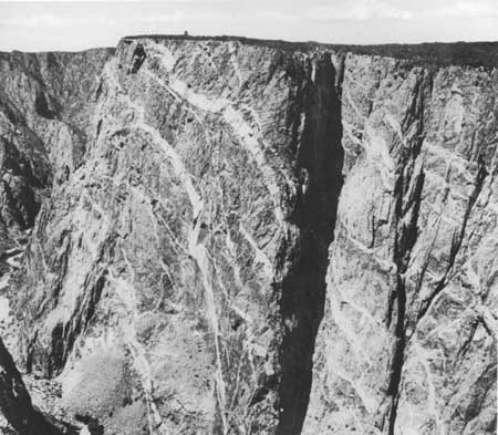
| Painted Wall, Black Canyon of the Gunnison National Monument. Greatest cliff in Colorado, Painted Wall averages about 2,250 feet from rim to river. Cliff is carved from gneiss interlaced with pegmatite dikes. Deep fissures to right of center are controlled by weathering along joints. |
ILLUSTRATIONS
FIGURES
1. Comparative profiles of several well-known American canyons2. Location map of the Black Canyon area
3. The Narrows of the Black Canyon
4. Talus blocks in canyon bottom at foot of Painted Wall, August 29, 1963
5. Chasm Wall at north end of Vernal Mesa
6. Major divisions of geologic time
7. Critical stages in the development of the Black Canyon landscape
8. Rock formations of the Black Canyon area
9. Contorted gneiss, north rim of Black Canyon near Colorado State Highway 92
10. Hand specimen of Vernal Mesa Quartz Monzonite
11. Curecanti Needle, 6 miles downstream from head of Black Canyon
12. Stereogram of the Curecanti pluton
13. Pegmatite dike intruding biotite gneiss
14. Dikes of lamprophyre cutting across biotite gneiss
15. Black Canyon of the Gunnison National Monument and vicinity, Colorado
16. Ancestral Uncompahgre highland just before Entrada Sandstone was deposited
17. Stratigraphic section near mouth of Smith Fork
18. Craggy outcrops of West Elk Breccia
19. Generalized section across Gunnison uplift
20. Isolated pinnacles of quartzitic gneiss
21. Cimarron fault, north across valley of Squaw Creek
22. Block diagram showing lateral and vertical passage of a fault into a monocline
23. Structure contour map drawn at the base of the ash-flow tuff volcanic sequence
| <<< Previous | <<< Contents >>> | Next >>> |
bul/1191/contents.htm
Last Updated: 28-Mar-2006