
|
Geological Survey Bulletin 1291
The Geologic Story of the Uinta Mountains |
GEOGRAPHIC SETTING
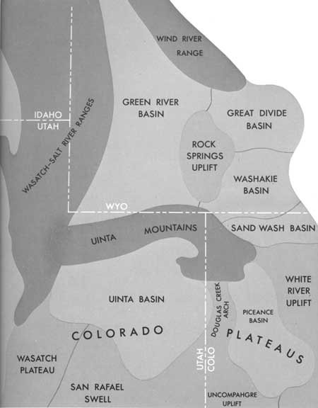
GEOGRAPHERS divide the Rocky Mountain System in the Western United States into three parts: the Northern, Middle, and Southern Rocky Mountains. The Middle Rocky Mountains, of which the Uintas are a part, extend southward from southern Montana, through eastern Idaho and western Wyoming, into central Utah and include such ranges as the Teton, Wind River, Salt River, and Wasatch. The Uintas are bounded on the north (fig. 1) by the Green River Basin, the Rock Springs uplift, and the Washakie and Sand Wash Basins. They are bounded on the south by the Uinta and Piceance Basins, which are separated by the Douglas Creek arch. Thus, the Uinta Basin is the counterpart of the Green River Basin; the Douglas Creek arch is the counterpart of the Rock Springs uplift; and the Piceance basin is the counterpart of the Washakie and Sand Wash Basins. The Uinta Basin, the Douglas Creek arch, and the Piceance basin are components of the Colorado Plateaus province; hence, the south margin of the Uinta Mountains also coincides with the north margin of the Colorado Plateaus.
|
| REGIONAL GEOGRAPHIC SETTING of the Uinta Mountains, showing distribution of mountainous uplifts and basins. Darkest shading indicates Middle Rocky Mountains. (Fig. 1) |
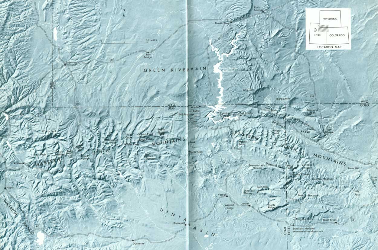
The Uinta Mountains have an overall length of about 150 miles and a mean width of about 35 miles. At their widest, toward the west, they are more than 45 miles across, and at their narrowest near the center of the range, they are less than 30 miles across. The boundaries are somewhat indefinite, inasmuch as the flanks pass into bordering hogback ridges and broad sloping mesas that merge gradually with the high arid tablelands of the adjacent basins. Figure 2 gives an overall impression of the setting and shape of the range.
|
| THE UINTA MOUNTAINS. (click on image for an enlargement in a new window) (Fig. 2) |
The Uinta Mountains have been carved from an immense anticlinal uplift, an upward flexing of the earth's crust which nearly coincides with the outer limits of the range. This great fold is described in some detail on the pages that follow. Down through countless centuries, the fold has been attacked and dissected by the elements, and in its present eroded form, it is largely responsible for the overall character of the range.
For a better understanding of the physical and spatial relations of the Uinta Mountains, topographic maps are an invaluable aid. Good topographic coverage is available at small scales for the entire range, and at modern large scales for most of it. Modern detailed maps by the U.S. Geological Survey are published at a scale of 1:24,000 (2,000 feet per inch). These maps, with a green forest overprint, show roads, trails, buildings, lakes, meadows, and springs, and they identify most of the named landmarks. The old Coalville (1900), Hayden Peak (1901), Gilbert Peak (1905), and Marsh Peak (1906) quadrangle maps, at a scale of 1:125,000 (2 miles per inch), show graphically most of the west half of the range, although most of the altitudes have been revised with modern mapping, and the culture is out of date. These fine old maps are slowly disappearing from stock and soon will be collector's items. Regional relations are very well shown by the 1:250,000 (4 miles per inch) Salt Lake City and Vernal topographic sheets, which together portray the entire range. These maps were prepared by the U.S. Army Map Service and are published in civil edition by the U.S. Geological Survey. Plastic raised-relief editions of these maps, available from the U.S. Army Map Service, depict the physiography exceedingly well in three dimensions and enable the user to see the form of the mountains in a way not otherwise possible. Excellent forest maps of the Wasatch and Ashley National Forests are available from the U.S. Forest Service. These maps show roads, trails, peaks, streams, and lakes and include a large part of the Uinta Mountains.
| <<< Previous | <<< Contents >>> | Next >>> |
bul/1291/sec1.htm
Last Updated: 18-Jan-2007