
|
Geological Survey Bulletin 1309
The Geologic Story of Isle Royale National Park |
THE ISLAND IN HISTORY
Geology influenced the role that Isle Royale played in both pre-historic and historic activities of man in the Lake Superior region. Native copper implements, weapons, and ornaments have been found in Indian mounds and habitats throughout central and eastern North America, some of which probably date back to 3,000 B.C. Undoubtedly, most of this copper came from the Lake Superior region and perhaps a significant part from Isle Royale. Even today, hundreds of Indian mining pits can be seen scattered throughout the park. The major concentration of these pits is near McCargoe Cove, where many were reexcavated later by miners and archaeologists. A charred log recovered from one of these pits yielded a radiocarbon age of about 1,500 B.C., attesting to the antiquity of these early mining operations.
The existence of native copper in North America was known to the European explorers as early as Cartier's second voyage in 1535-36. It was said to have come from the direction of the Lake Superior region. Not until the Jesuit missionaries penetrated the region more than a hundred years later, however, did more definite information as to the source of the copper become available, but even much of that was inaccurate. In the "Jesuit Relation" for 1669-70, a Father Dablon cites Indian legends regarding "an is land called Menong [Minong], celebrated for its copper," including a rather extravagant description of the abundance of the metal. Minong was the Indian general term for island but was specifically applied to Isle Royale; it has been perpetuated on the island as Minong Ridge. As exploration continued, additional information about the sources of the copper was accumulated, and actual prospecting on Isle Royale began in 1843, the year in which the Chippewas relinquished their claims to the island. By 1850 copper mining by Europeans was established on Keweenaw Peninsula and had been attempted on Isle Royale (fig. 1).
|
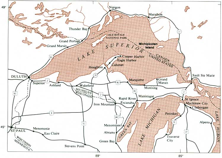
| REGIONAL SETTING of Isle Royale National Park. (Fig. 1) (click on image for an enlargement in a new window) |
In 1847 the U.S. Congress authorized a survey of the vast Lake Superior Land District to determine its mineral potential, and the result of this survey was the first series of comprehensive reports on the geology of the region. Charles T. Jackson's report of 1849 contains the first map of Isle Royale to show in a very general way the different rock types present on the island. Two following reports, both by John w. Foster and Josiah D. Whitney in 1850 and 1851, include an improved geologic map of Isle Royale and a wealth of information on the early mining activities on the island. Whitney later became the first State Geologist of California, and the highest mountain in the conterminous United States is named for him. These three reports show an amazingly sophisticated understanding of the general geology of the region, especially considering the limited amount of time that was spent exploring such a vast and nearly trackless wilderness. Foster and Whitney lucidly describe some of the difficulties in working on Isle Royale.
The physical obstructions to a successful exploration of the island are greater than we encountered in any other portion of the mineral district. The shores are lined with dense but dwarfed forests of cedar and spruce with their branches interlocking and wreathed with long and drooping festoons of moss. While the tops of the trees Boorish luxuriantly, the lower branches die off and stand out as so many spikes, to oppose the progress of the explorer. So dense is the interwoven mass of foliage that the noonday sunlight hardly penetrates it. The air is stiffled; and at every step the explorer starts up swarms of musquitoes, which, the very instant he pauses, assail him.
And so it remains today, but at least the modern explorer has relatively effective mosquito repellent available to him. Among the more astute conclusions reached by Jackson and by Foster and Whitney is that Isle Royale and the Keweenaw Peninsula may be regarded as geologic counterparts on the opposite sides of a structural basin occupied by Lake Superior. They also predicted correctly that "the island, for mining purposes, may be regarded as infinitely less valuable than Keweenaw Point."
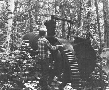
The first period of mining activity on Isle Royale from 1843 to 1855, ended with much disappointment as no economic deposits were found. Mining was renewed during the period from 1873 to 1881 with the development of the Minong and Island mines. Although these two mines were the most productive ever to be opened on the island, they also were uneconomic, and this mining revival was short lived (fig. 2). Finally, from 1889 to 1893, an extensive exploration program was undertaken on the west end of the island, east of Washington Harbor. No economic deposits of copper were located, however, and the efforts were abandoned.
|
| HOIST AND BOILER REMAINS at Island mine, abandoned in 1877. (Fig. 2) |
It was during this latest period of exploration that the most detailed and comprehensive study of Isle Royale to date was made by Alfred C. Lane of the Geological Survey of Michigan. His geologic map and report were published in 1898. The timing of this study was fortunate indeed, as samples obtained with diamond drills during the mineral exploration of this period were made available to Lane and permitted him to work out the succession of rock strata—the stratigraphy—of the island in much greater detail than would have been possible from the very incomplete sequence to be seen in natural rock exposures. The samples also permitted him to make stratigraphic correlations between Isle Royale and the Keweenaw Peninsula, which are for the most part still valid today. Lane's report was so comprehensive that until very recently only a few additional studies of limited geologic scope have been made on the island; most of these have been related to the glacial and post-glacial geologic history. Many other studies throughout the Lake Superior area, however, have given us a better understanding of the regional geologic setting within which we must view Isle Royale.
Recent field studies undertaken by myself, and Roger G. Wolff, have resulted in a series of technical publications on the geology of Isle Royale, which are listed at the end of this re port. Included is a new geologic map (Huber, 1973c), published separately, which can profitably be used as a companion to this report. The map is at a sufficiently large scale (1 in. = 1 mi.) to show details of the geology of Isle Royale not possible to show at the scale of maps in this report. In fact some of the geologic units described in this report are shown only on the larger map, which is also recommended for place names.
| <<< Previous | <<< Contents >>> | Next >>> |
bul/1309/sec1.htm
Last Updated: 28-Mar-2006