
|
Geological Survey Bulletin 1309
The Geologic Story of Isle Royale National Park |
THE WAY THE ROCKS ARE STACKED UP
The bedrock sequence on Isle Royale consists of a thick pile of lava flows and sedimentary rocks that has been tilted toward the southeast. Having already looked briefly at the different varieties of rocks that occur in the pile, we can now examine the rock sequence in more detail and get to know the subtleties of its character and the relative position or succession of its component parts—its stratigraphy.
In geology, a formation is an assemblage of rocks that have some character in common, whether of origin or composition. It is thus a way of dividing rocks into manageable units for discussion or for depiction on a geologic map. The rock sequence on Isle Royale has been divided into two formations, one deposited above the other. The lower—and thus older—one has been named the Portage Lake Volcanics and includes all the lava flows and their minor interbedded sedimentary and pyroclastic rocks. The upper formation, the Copper Harbor Conglomerate, contains only sedimentary rocks; it is mostly conglomerate but also includes sandstone. On the Keweenaw Peninsula of Michigan, where these formations also occur and were originally named, other formations can be seen both above and below the Portage Lake Volcanics and Copper Harbor Conglomerate. Some of the other formations undoubtedly also extend to the vicinity of Isle Royale, but they are concealed beneath the waters of Lake Superior.
A VOLCANIC PILE—THE PORTAGE LAKE VOLCANICS
There are probably over 100 individual lava flows in the Portage Lake Volcanics on Isle Royale with a total thickness of over 10,000 feet—quite an impressive pile. And the total thickness of the formation must be greater because although the top of the formation is exposed, the bottom is not, and an unknown number of additional flows undoubtedly lie beneath Lake Superior on the north side of the island.
The sedimentary rocks interbedded with the lava flows are exposed only under unusual circumstances because they are more easily eroded than the volcanic rocks and as a result are generally buried beneath surficial materials in depressions between ridges of more resistant volcanic rock. We know from holes drilled during exploration for copper deposits that about 25 sedimentary layers 1 foot thick or more are present in the sequence; however, less than a third of these layers are known from outcrop, and all those are in the upper part of the sequence.
In order to construct a geologic map, which shows the geographic distribution of individual rock units and their relationships to each other, some method must be found of distinguishing key rock units from each other; usually, rock composition does the trick. But within a pile of similar lava flows, this is a distinct problem. Fortunately, some of the lava flows in the Portage Lake Volcanics can be distinguished from their neighbors above and below on the basis of their distinctive rock textures. These flows can then be used as divisions or marker units within the sequence of flows and can provide stratigraphic and structural control for depicting the sequence on a geologic map. The interbedded sedimentary rocks would also serve as marker units for mapping if they were exposed more frequently.
The amygdaloidal zones at the base and top of flows are less resistant than the massive flow interiors; therefore, the interior parts of the thicker flows are the dominant ridge-forming units. Contacts between flows, on the other hand, are seldom exposed as they are generally concealed beneath alluvial materials or talus in the depressions between ridges. Fortunately for geologic mapping, the distinguishing texture of an individual flow is generally better developed and more readily apparent in the nonamygdaloidal flow interiors, and therefore, that part of a flow most useful for purposes of identification is invariably the most likely part to be exposed.
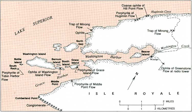
The volcanic rocks on Isle Royale are predominantly ophitic, and except for a few unusual ophites, the nonophitic flows are most conspicuous among their neighbors and make the best horizon markers. The finer grained porphyrites and traps are also generally more resistant to erosion than ophitic flows of similar thickness and thus tend to stand out topographically, making it easier to trace them across the countryside and adding to their usefulness in geologic mapping. There are 12 flows within the Portage Lake Volcanics on Isle Royale that are distinctive enough to be easily separated from the rest of the flows in the pile, and these have been named for ease of reference (fig. 17). Most of these named flows are less than 100 feet thick, but six of them can be traced the length of the island. The named flows include five porphyrites, four traps, and three ophites. Only four of these individual flows are shown on the geologic map in this volume (pl. 2), but all are shown on the larger scale geologic map published separately (Huber, 1973c).

|
| PORTAGE LAKE VOLCANICS—schematic columnar section on Isle Royale. Not drawn to scale. (Fig. 17) (click on image for an enlargement in a new window) |
For most visitors to Isle Royale, the northeast and southwest ends of the island are the most accessible, although a growing number of visitors are hiking the length of the island on the Greenstone Ridge Trail, which follows Greenstone Ridge, the backbone of the island. At neither end of the island can all the named lava flows or volcanic rock types be readily seen, but enough variety is present to provide interesting geological excursions from Rock Harbor Lodge and Windigo Inn via small boats available at both places. A somewhat less varied assortment of rocks can be seen on short hikes from the lodge areas.
Rock Harbor—Tobin Harbor Area
Most of the rock types in the Portage Lake Volcanics can be seen in the Rock Harbor—Tobin Harbor area (pl. 1). The main exception is the coarse porphyrite characteristic of the Huginnin Flow (fig. 12D), which can only be seen on the north side of the island.
All the volcanic rocks on the chain of islands on the south side of Rock Harbor are ophitic, and excellent exposures can be found on the wave-buffeted south shores of those islands. Ophitic texture is especially well developed on the south side of Raspberry Island where exposures are readily accessible via the Raspberry Island Nature Trail (fig. 13 is from this locality). Ophite can also be seen along the Commodore Kneutson Trail near the Rock Harbor Lodge.
Fine-grained porphyrite can be seen in the Scoville Point Flow at various points on the north shoreline of Rock Harbor, as at Threemile Campground, on Scoville Point, and on the south sides of Edwards and North Government Islands. Its speckled appearance is quite distinctive (fig. 12B). Rock with a somewhat similar texture (fig. 12C) can be seen in the Tobin Harbor Flow at various points along the north shoreline of Tobin Harbor, as near the dock for the Lookout Louise Trail, on several small islands in Tobin Harbor, and on the south side of Porter Island. The trail to Mount Franklin also surmounts a bold outcrop of the Tobin Harbor Flow shortly after crossing Tobin Creek.
Fine-grained trap of the Edwards Island Flow can best be seen on the small promontory just north of Scoville Point, on Split Island, and on the north sides of Edwards and North Government Islands. Trap of the Long Island Flow can be seen on several small islands opposite the dock for the Lookout Louise Trail and on Long and Third Islands. The Edwards Island Flow and to a lesser extent the Long Island Flow have an important secondary attribute that helps in their field recognition; except for the upper part of the Greenstone Flow, they are the only flows in the volcanic sequence that commonly exhibit well-developed columnar jointing (fig. 18).
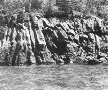
|
| COLUMNAR JOINTING IN EDWARDS ISLAND FLOW, Edwards Island. (Fig. 18) |
Columnar joints are cracks that divide a lava flow into long vertical columns ideally tending toward a hexagonal cross section. They are formed during cooling of the flow under certain specific conditions. Rapid and uniform cooling rates tend to promote the development of columnar joints, but the degree of homogeneity of the solidifying rock is probably more important. It can be shown mathematically that the surface of a homogeneous medium should be divided by a crack system defining regular hexagons when it is subjected to uniform tension because a hexagonal system provides the greatest stress relief with the fewest cracks. Regular hexagons are rare, however, because cooling stresses in rocks are never completely uniform and the columns are generally bounded by curved cracks forming irregular-shaped polygons with variable numbers of sides. "Ideal" cooling conditions are never reached at the surface of a flow. However, as a progressive zone of cooling, solidification, and cracking proceeds from the surface of a flow into its interior, a point may be reached where the shrinkage forces may be uniform enough for earlier irregular jointing to give way to the formation of columnar joints. The importance of the homogeneity of the cooling rock explains why in the Portage Lake Volcanics well-developed columnar jointing is restricted to the very fine grained traps and has only a very slight tendency to form in the coarser grained porphyritic and ophitic rocks.
Columnar jointing can be seen in the Edwards Island Flow at all the localities mentioned previously. Other accessible areas where columnar jointing can be observed are where the trail from Rock Harbor to Mount Franklin crosses the flow and on the south slope of Ransom Hill just west of the trail from Daisy Farm Campground to Mount Ojibway. The Greenstone Flow is the thickest flow on the island and holds up the most prominent ridge running the length of the island, Greenstone Ridge. The Greenstone Ridge Trail, which follows the ridge for nearly its full length, provides access to numerous scattered outcrops, but only at the far northeast end of the island near Blake Point is a reasonably complete cross section of the flow exposed. There the flow can be seen to consist of four divisions with approximate thicknesses as indicated: a lower ophitic zone (100 ft), a central pegmatitic zone (75 ft), an upper ophitic zone (175 ft), and aii uppermost columnar-jointed trap (50 ft), for a total thickness of about 400 feet. The Greenstone Flow attains its greatest thickness in the central part of Isle Royale, where it is estimated to be nearly 800 feet thick.
The lower ophitic zone, which makes up the cliffs of the Palisades on the north side of Blake Point, is of partictular interest as it is matched in coarseness only by the ophite of the Hill Point Flow; each has augite crystals as much as 2 centimetres in diameter. The pegmatite is best seen in the vicinity of the lighthouse on Blake Point. The columnar—jointed trap that forms the uppermost part of the Greenstone Flow is exposed on the string of small islands south of Merritt Lane, on Red Rock Point, and at a few additional isolated localities on the main island.
An excursion to Blake Point is also a botanical experience, as a rather unusual shrub fills a small ravine just west of the lighthouse—devilsclub. The entire plant, including its giant leaves, is profusely armed with sharp spines, and anyone who ventures to walk through a thick stand of these would appreciate the plant's specific name—Oplopanax horridum (fig. 19). It presence on Isle Royale is truly remarkable, for it appears nowhere else in the United States east of the Rocky Mountains; at Isle Royale it is found only near Blake Point, on Passage Island, and on a few of the small islands in the Rock Harbor area.
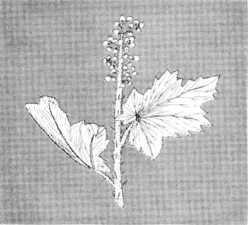
|
| DEVILSCLUB. (Fig. 19) |
Pyroclastic and sedimentary rocks are exposed in only a few localities in the Rock Harbor—Tobin Harbor area. Pyroclastic rock can be seen on the north shore of Tobin Harbor opposite Newman Island and on Porter Island above (southeast of) the columnar-jointed upper part of the Greenstone Flow. The rock is a tuff-breccia, composed of angular fragments of volcanic rock cemented together by ash (fig. 20). The ash was in a hot and partly plastic state when deposited and was then fused into a coherent mass upon cooling.
|
| PYROCLASTIC ROCK—note fragmental character. (Fig. 20) |
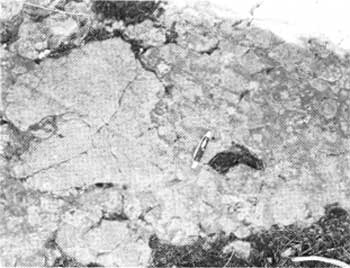
An extensive wave-swept outcrop of conglomerate is exposed at the southwest end of Mott Island, and a few other less accessible outcrops are scattered along the rest of the chain of islands south of Rock Harbor (fig. 21). Volcanic rocks of many varieties can be identified as pebbles in the conglomerate. Many of them are of rhyolite or other types different from those that form the bulk of the Portage Lake volcanic sequence and must have been derived elsewhere.
|
| CONGLOMERATE ON MOTT ISLAND (southwest end of island) showing pebbly surface. (Fig. 21) |
Washington Harbor Area
The southwest end of Isle Royale is mantled with a much thicker blanket of glacial till and other surficial materials than the northeast end, and consequently, outcrops are common only along shorelines with exposure to storm waves. In the Rock Harbor—Tobin Harbor area, we were discussing rocks that make up the upper part of the volcanic sequence, that is rocks from the Greenstone Flow upward in the sequence. In the Washington Harbor area, most exposures are of the sequence downward from the Greenstone Flow (fig. 22).
|
| WASHINGTON HARBOR AREA—selected outcrops of various rock types. (Fig. 22) (click on image for an enlargement in a new window) |
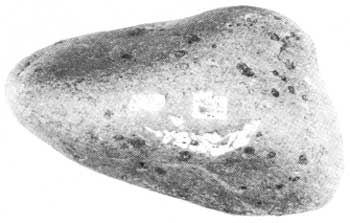
Most of the rocks exposed in the Washington Harbor area are of ophitic basalt, as for example on the series of small promontories from North Gap northward. Exceptionally coarse ophite can be seen in the Hill Point Flow at the entrance to Huginnin Cove, accessible via the Huginnin Cove Trail as well as by boat. Some large loose slabs of the coarse porphyrite of the Huginnin Flow lie on the west shore of cove (fig. 23), and excellent exposures of that flow can be seen on the north shore of the island about half a mile southwest of the cove. Working upward in the volcanic sequence, trap of the Minong Flow is exposed along the Huginnin Cove Trail and forms a small promontory near the northwestern most corner of the main island.
|
| HUGINNIN FLOW PORPHYRITE—sample of the loose slab from Huginnin Cove. (Fig. 23) |
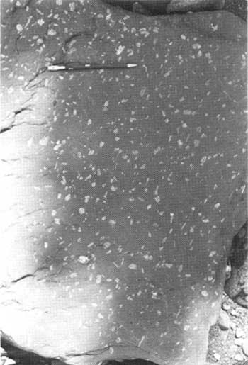
Outcrops of the coarse porphyrite of the Grace Island Flow are found on Grace Island just south of the campground, on Booth Island, and near both ends of Washington Island. Beach cobbles of rock from this flow are readily identifiable (fig. 24).
|
| GRACE ISLAND FLOW PORPHYRITE—sample of beach cobble from Grace Island. (Fig. 24) |
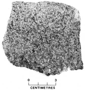
The rock of the Washington Island Flow is difficult to describe but distinctive when seen; perhaps A. C. Lane's application of the term "glomeroporphyritic ophite" suggests the problem. The rock is definitely an ophite, but the ophitic texture is obscure; instead the rock is characterized by a speckled appearance due to the rather uniform distribution of greenish splotches of chlorite (fig. 25). The Washington Island Flow is well exposed on the south side of Washington Island where it overlies the Greenstone Flow and caps the highest ridge.
|
| WASHINGTON ISLAND FLOW OPHITE showing distinctive dark splotches of chlorite. (Fig. 25) |
South Rock, just southwest of Washington Island, is a herring gull rookery. It is also one of only two small outcrops of fine-grained porphyrite that are reasonably accessible near the west end of Isle Royale. It is believed to be part of the Tobin Harbor Flow. Another very small outcrop of porphyrite of the Middle Point Flow can be seen on the south shore of Grace Harbor about half a mile northeast of Middle Point.
| <<< Previous | <<< Contents >>> | Next >>> |
bul/1309/sec4.htm
Last Updated: 28-Mar-2006