
|
Geological Survey Bulletin 1309
The Geologic Story of Isle Royale National Park |
THE WAY THE ROCKS ARE STACKED UP
(continued)
AN ANCIENT ALLUVIAL FAN—THE COPPER HARBOR CONGLOMERATE
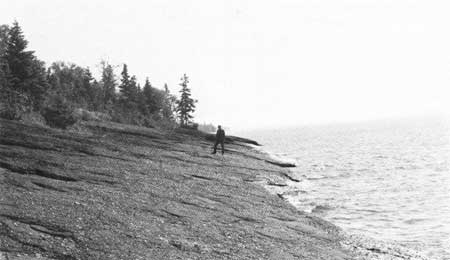
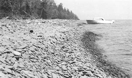
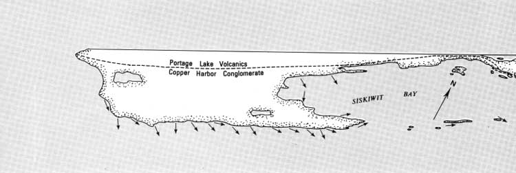
The shoreline of the southwestern part of Isle Royale from Cumberland Point to Malone Bay lacks the dark, forbidding cliffs typical of most of the island. There in many places rusty-red rocks slope rather gently down to the water (fig. 26). Pebble beaches are moderately abundant, whereas they are quite rare elsewhere (fig. 27). It is readily apparent that the entire appearance of the island is different here, and the reason is geologic. This part of the island is underlain by sedimentary rocks of the Copper Harbor Conglomerate.
|
| COPPER HARBOR CONGLOMERATE sloping gently southeast into Lake Superior near Attwood Beach. (Fig. 26) |
|
| SANDSTONE PEBBLE BEACH west of Little Boat Harbor. National Park Service boat D. J. Tobin provided transportation for geologic studies. (Fig. 27) |
The name of this formation is somewhat misleading because on Isle Royale it includes an appreciable amount of sandstone as well as conglomerate. On the Keweenaw Peninsula where the formation was originally defined, however, conglomerate is overwhelmingly predominant and hence the name. We shall see that within this formation on Isle Royale there is a definite pattern to the distribution of the sandstone and conglomerate that helps us to interpret where and how the original sediments were laid down.
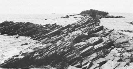
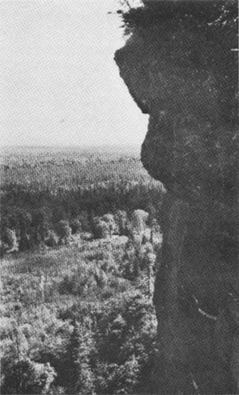
The sedimentary rocks, especially the sandstones, commonly exhibit a well-developed parting parallel to the original layering or bedding in the rock (fig. 28). It is this parting, along with the lakeward slope of the strata, that permits storm waves to remove thin slabs of rock so as to produce a shore that slopes into the water. However where the parting slopes away from rather than toward the water, as on the north sides of islands and promontories, cliffs form. What is probably the highest sheer cliff on Isle Royale is cut into conglomerate on the north side of Feldtmann Ridge (fig. 29).
|
| SLABBY SANDSTONE outcrops on Stone House Island. (Fig. 28) |
|
| CLIFF IN COPPER HARBOR CONGLOMERATE on north side of Feldtmann Ridge. (Fig 29) |
The sedimentary rocks of the Copper Harbor Conglomerate are similar to those interbedded with the Portage Lake Volcanics. The pebbles and sand making up these rocks have predominantly been derived by erosion from volcanic rocks, many of which are similar to those exposed on the island, but many of which are more felsic (higher in silica, see p. 12). The felsic varieties can be recognized by their generally reddish tint. Agate pebbles that are locally abundant in the conglomerate are amygdules from volcanic rocks.
The rock sequence of the Copper Harbor Conglomerate is far from completely exposed on Isle Royale as nearly half its total thickness is concealed beneath the mud and water, black spruce, white cedar, and bog mats of the Big Siskiwit Swamp. Nevertheless, enough can be deduced from the existing outcrops to reconstruct the environment in which the sediments were deposited and then to speculate upon the origin of the formation.
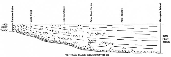
One clue comes from variations in thickness of the rock sequence. In spite of the fact that we cannot estimate the total thickness of the formation because the top lies beneath Lake Superior, the Copper Harbor Conglomerate has marker horizons that can be traced or projected for considerable distances, allowing us to calculate changes in thickness for equivalent parts of the formation. The thickness of the exposed part of the section increases rather steadily from Rainbow Point to the vicinity of Menagerie Island about 24 miles to the northeast (fig. 30). The Copper Harbor Conglomerate is a great wedge of sedimentary rock, and while we see it in only two dimensions, other clues will help to elucidate its nature more fully.
|
| COPPER HARBOR CONGLOMERATE—section showing changes in thickness and in coarseness of grain size. (Fig. 30) (click on image for an enlargement in a new window) |
Another clue lies in the variable coarseness of the sedimentary debris that makes up the formation. Near the base of the formation, on Cumberland Point, the rock is a very coarse boulder conglomerate with boulders as much as 2 feet in diameter. Eastward the conglomerate decreases in coarseness, finally grading entirely into sandstone east of Malone Bay. Higher in the formation a similar change can be seen from boulder conglomerate at Rainbow Point and cobble and pebble conglomerates along the shore south of Feldtmann Ridge to sandstone on Houghton Point and on the chain of islands on the south side of Siskiwit Bay. Thus the size of the stones in the conglomerate decreases as the formation increases in thickness. This decrease in grain size suggests a corresponding increase in distance from the source of the sedimentary debris, as fine materials can be transported farther than coarse materials under the same conditions.
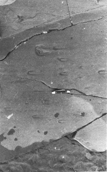
Other evidence regarding the location of the source of the sediments comes from structures preserved in the rocks themselves. Some of these structures indicate current direction and thus presumably the direction sand and gravel were carried. An example is a structure formed by the deflection of the water current around larger-than-average fragments (fig. 31). Analysis of such features in the Copper Harbor Conglomerate indicates that the direction of sediment transport was generally eastward (fig. 32).
|
| WATER-CURRENT FEATURE formed by flow deflected around shale fragments. Direction of current flow is toward the right (Fig. 31) |
|
| DIRECTIONS OF SEDIMENT TRANSPORT for the Copper Harbor Conglomerate. (Fig. 32) (click on image for an enlargement in a new window) |
One other clue helps to nail down the source area—the composition of the pebbles themselves. Felsites and some of the other volcanic rocks that occur as pebbles in the Copper Harbor Conglomerate are not found in flows in the exposed Portage Lake Volcanics on Isle Royale. However, such rock types are found in a somewhat older sequence of volcanic flows exposed on the north shore of Lake Superior in Minnesota, exactly in the direction indicated as the source by the current structures, the distribution of coarse conglomerate, and the thinning of the sedimentary wedge. As a well-known expert might say, happiness is having the right kind of rocks in the right place.
To sum up, the Copper Harbor Conglomerate is a vast wedge of sedimentary rock derived from volcanic rocks in what is now Minnesota and transported generally eastward to its present site on Isle Royale, with, as might be expected, the fine sediment particles being transported farther than the coarse ones. But what can we say about the nature of conditions at the time and place of deposition?
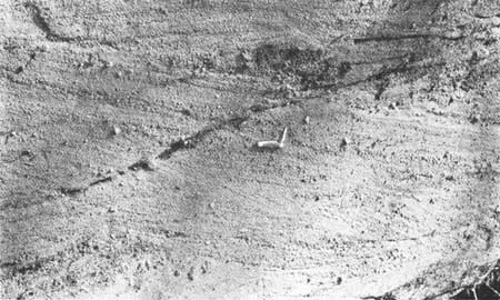
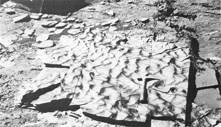
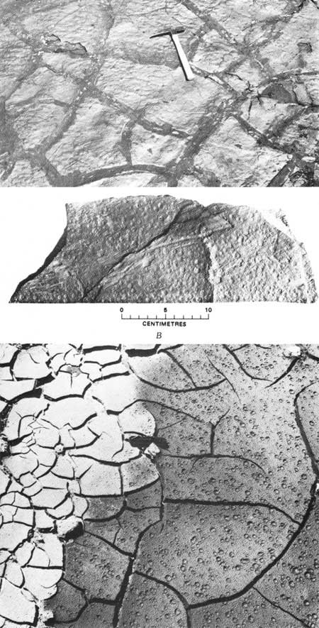
Most of the bedding structures as well as the lenticular form of zones of differing coarseness in the conglomerates are characteristic of deposits associated with the flowing water of streams and rivers rather than lakes or oceans. Irregular scour-and-fill structure (fig. 33) is characteristic of sediment deposited by braided streams, ones flowing in dividing, reuniting, and constantly shifting channels resembling the strands of a braid (fig. 34). Some of the structures, such as ripple marks (fig. 35), do indicate deposition in standing bodies of water. But associated desiccation cracks and raindrop impressions (fig. 36) indicate that those bodies of water were temporary ones, such as might occur on river floodplains or mud flats.
|
| SCOUR-AND-FILL STRUCTURE in pebbly sandstone, Chippewa Harbor area. (Fig. 33) |
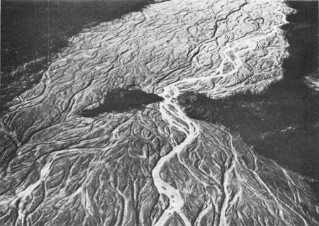
|
| BRAIDED STREAM CHANNEL of the Muddy River, Alaska. Photograph by Bradford Washburn. (Fig. 34) |
|
| RIPPLE MARKINGS on sandstone, west of Attwood Beach. Photograph by R. G. Wolff. (Fig. 35) |
|
| ANCIENT DESICCATION CRACKS (A) AND RAINDROP IMPRESSIONS (B) on siltstone at Isle Royale compared with similar features (C) on modern drying mud. Photograph of modern features by D. M. Baird. (Fig. 36). |
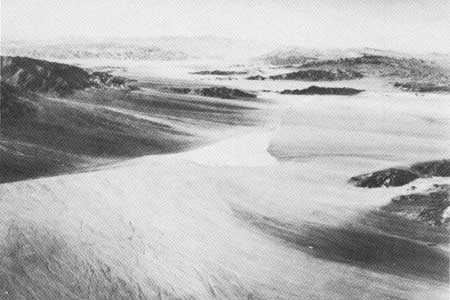
The closest analogy we can find today of a sedimentary deposit with the features of the Copper Harbor Conglomerate are the massive alluvial fan deposits and associated finer grained playa deposits in arid regions of the American West (fig. 37). The formation of such deposits requires very rapid, flash-flood runoff after rainstorms, rather than the continuously flowing water of permanent streams, and lack of vegetation is the key element permitting this to happen. This analogy does not necessarily mean that the Copper Harbor Conglomerate was deposited in a desert, for at the time the deposit was formed vegetation did not yet exist on land. In Precambrian time (see p. 36), before the appearance of a significant plant cover, erosion and runoff rates were high; floods were large, and coarse sediments were spread over piedmont areas more readily and rapidly than under modern conditions. Thus, the Copper Harbor Conglomerate on Isle Royale is a massive piedmont fan deposit, with associated flood plaint or playa deposits, that was spread out over the Portage Lake Volcanics from a bordering highland area to the west.
|
| ALLUVIAL FANS AND PLAYAS in Death Valley, Calif. From "Geology Illustrated" by John S. Shelton, W. H. Freeman and Company (copyright 1966). (Fig. 37) |
| <<< Previous | <<< Contents >>> | Next >>> |
bul/1309/sec4a.htm
Last Updated: 28-Mar-2006